What is LiDAR?
LiDAR, which stands for Light Detection and Ranging, is a remote sensing technology that measures distance by illuminating a target with a laser and analyzing the reflected light. It is often used for creating high-resolution maps and 3D models of environments, and has applications in various fields such as geodesy, archaeology, geography, and autonomous vehicles.

How Does LiDAR Work?
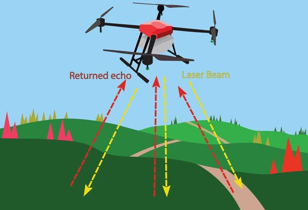
- Time-of-Flight Measurement: The core principle of LiDAR is the time-of-flight measurement, where a laser pulse is emitted and the time it takes for the pulse to travel to the target and back is measured. This time is then used to calculate the distance to the object using the speed of light.
- Laser Pulse Reflection: LiDAR systems emit short, intense laser pulses that reflect off surfaces in the environment. The reflected pulses are then detected by the system, allowing for the calculation of distances.
- Data Collection: By scanning the environment, LiDAR systems collect a large number of distance measurements, which are then used to create detailed 3D models. This can be done through various scanning methods, including mechanical scanning or using technologies like MEMS (Micro-Electro-Mechanical Systems) or optical phased arrays.
Advantages of LiDAR
- High Accuracy: LiDAR provides highly accurate distance measurements, often with centimeter-level precision, making it suitable for a wide range of applications.
- Speed: LiDAR systems can quickly capture a large amount of data, allowing for efficient surveying and mapping.
- Immunity to Interference: Unlike some other distance-sensing technologies, LiDAR is not affected by electromagnetic interference, making it reliable in various environments.
- Versatility: LiDAR can be used in various applications, including surveying, mapping, forestry, autonomous vehicles, and more, due to its ability to create detailed 3D models.
- Data Density: LiDAR can capture a high density of data points, providing detailed and accurate representations of environments.

Challenges and Limitations of LiDAR
- Range Limitations: Traditional LiDAR systems can struggle with accurate measurements for near objects due to signal non-linearities.
- Atmospheric Interference: Atmospheric conditions such as fog, dust, and rain can affect the accuracy of LiDAR measurements.
- Cost: High-cost LiDAR systems can be a limitation for widespread adoption, although costs are decreasing for large-scale applications.
- Data Processing Complexity: The large amount of data generated by LiDAR systems requires complex processing to create useful information.
- Limited Range Resolution: The range resolution of LiDAR is limited by the width of the laser pulse, which can affect the ability to distinguish between closely spaced objects.
Applications of LiDAR
Surveying and Mapping
- LiDAR is widely used for creating high-resolution maps. It can produce detailed 3D models of the Earth’s surface, which is essential for geodesy, geomatics, archaeology, geography, and geology.
- Airborne LiDAR is used for mapping large areas, such as terrain, vegetation, and buildings, with high accuracy.
Autonomous Vehicles
- LiDAR is a crucial sensor in autonomous vehicles for applications like collision avoidance and cruise control systems.
- It provides real-time data for the vehicle to navigate and make decisions, enhancing safety and efficiency.
Atmospheric Physics
- LiDAR is used to study atmospheric conditions by analyzing the wavelength-dependent changes in the intensity of the returned signal.
- It helps in monitoring atmospheric components and understanding environmental changes.
Forestry and Agriculture
- In forestry, LiDAR is used for mapping tree heights, canopy density, and forest structure, aiding in forest management and conservation.
- In agriculture, it helps in precision farming by providing data on crop health, growth, and soil conditions.
Wind Energy
- LiDAR is employed to measure and optimize wind conditions for wind farms, improving energy production efficiency.
Robotics and UAVs
- LiDAR is used in robotics for object detection, navigation, and mapping.
- Unmanned aerial vehicles (UAVs) utilize LiDAR for surveying, mapping, and inspection tasks.
Smart Transportation
- LiDAR enhances smart transportation systems by providing data for intelligent traffic management and infrastructure planning.
Geomorphology and Seismology
- LiDAR is used in geomorphology to study landforms and processes, and in seismology for monitoring ground movements and earthquake studies.
Consumer Technology
- LiDAR is increasingly used in consumer technology for applications such as night vision displays and advanced 3D scanning.

Latest Technical Innovations in LiDAR
Photonics Technology Advancements
Recent progress in photonics technology has extended the capabilities of LiDAR systems, particularly in autonomous vehicles. This includes the development of photonic integrated chips that enhance the performance of LiDAR sensors.
Single Photon Detectors
The integration of single photon counting (SPC) detectors in LiDAR systems is gaining traction due to their high sensitivity and ability to achieve long detection ranges. This technology is crucial for improving the precision and range of LiDAR systems.
New Radiation Sources
Future LiDAR developments are focusing on exploring new sources of radiation to improve the performance and capabilities of LiDAR systems. This includes investigating alternative laser wavelengths and powers to enhance detection and accuracy.
Multi-Sensor System Integration
There is a growing emphasis on integrating LiDAR with other sensors to create multi-sensor systems. This integration aims to improve data fusion and overall system performance, enabling more accurate and comprehensive data collection.
Advancements in Sensor Design
Innovations in LiDAR sensor design are aimed at improving the scanning resolution, flexibility, and detection capabilities of LiDAR systems. This includes developing methods to optimize the transmission and reception of laser beams to enhance scanning performance.
Time-of-Flight (ToF) Cameras
The development of compact ToF cameras for indoor LiDAR measurements has increased the speed and efficiency of LiDAR data acquisition. These cameras can measure an entire field of view simultaneously, making them suitable for applications requiring high measurement speeds.
Flash LiDAR Technology
Flash LiDAR cameras, developed in the early 2000s, are widely used in autonomous vehicle navigation. This technology allows for rapid measurement of point clouds, which is essential for real-time obstacle detection and mapping.
To get detailed scientific explanations of LiDAR, try Patsnap Eureka.

Learn more
Shock Cords: Versatile Strength for Every Need
Pressure Switches: Small Devices, Big Impact
Unveiling The Lead Screw: Its Mechanism, Benefits, And Beyond
