Blind user navigation service system based on global positioning system (GPS) and 3rd-generation (3G) network

A blind navigation and 3G network technology, applied in location information-based services, transmission systems, telephone communications, etc., can solve problems such as poor accuracy, inability to contact family members or guardians in a timely and effective manner, and impracticality, so as to easily recognize characters and Objects, the effect of facilitating navigation and travel

Active Publication Date: 2011-09-14
CHINA HUALU GRP
View PDF4 Cites 45 Cited by
  • Summary
  • Abstract
  • Description
  • Claims
  • Application Information

AI Technical Summary

Problems solved by technology

Poor accuracy, hardly practical
However, if GPS positioning is used alone, the positioning accuracy will be greatly reduced in the street environment with many tall bui

Method used


Image

  • Blind user navigation service system based on global positioning system (GPS) and 3rd-generation (3G) network
  • Blind user navigation service system based on global positioning system (GPS) and 3rd-generation (3G) network
  • Blind user navigation service system based on global positioning system (GPS) and 3rd-generation (3G) network

Examples


Embodiment Construction

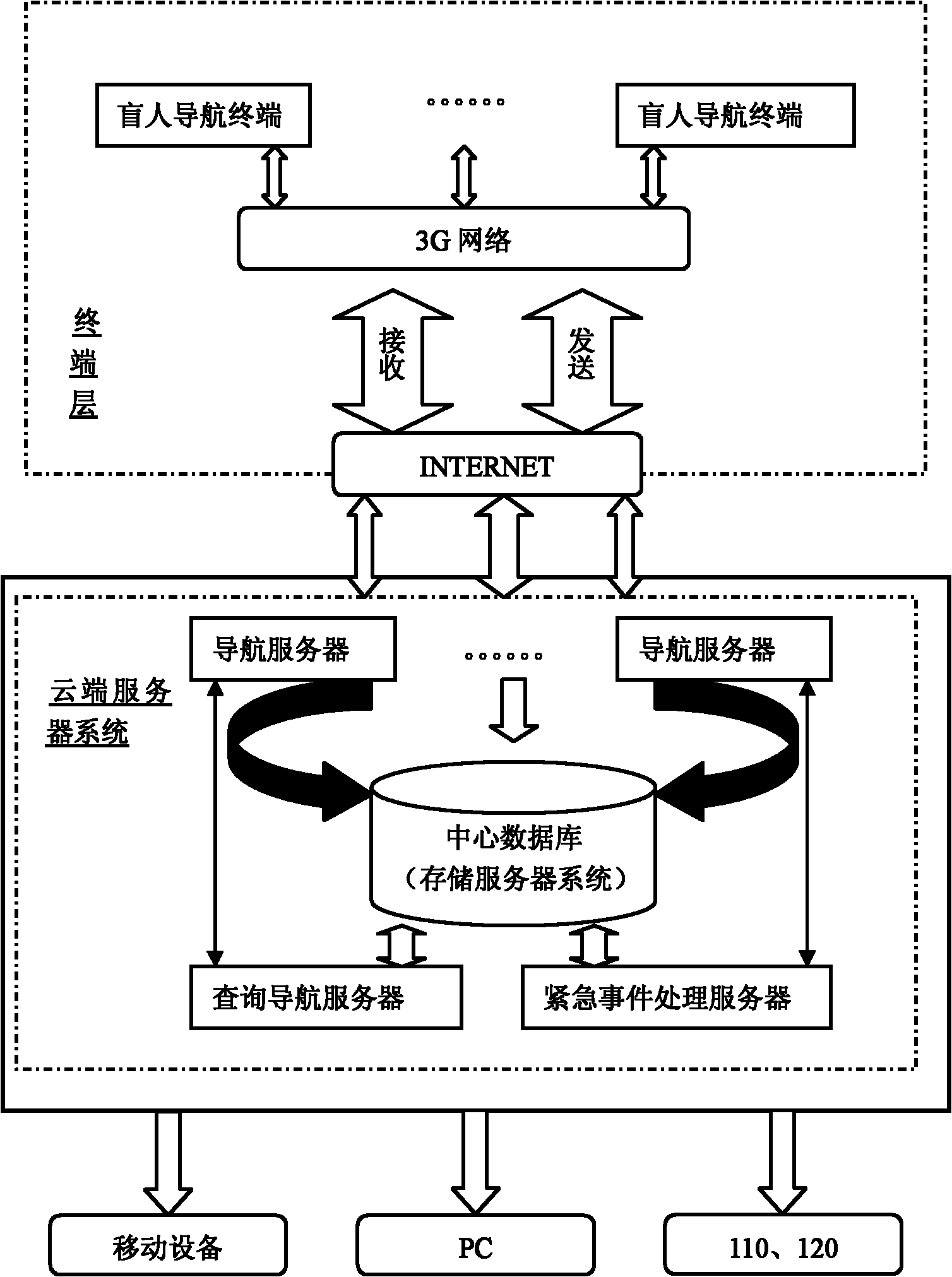
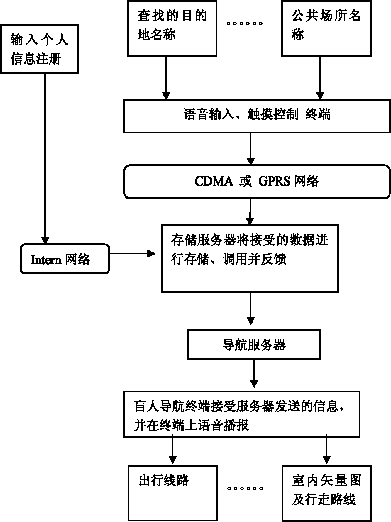
[0036] like Figure 1 to Figure 3 The navigation service system for the blind based on GPS and 3G network shown includes: a navigation terminal for the blind, which is used to obtain the current location information of the blind user, and sends the destination information of the blind user and the current location information of the blind user to the navigation server through the radio frequency module and download the travel plan given by the navigation server and the map of the area, and broadcast the overview of navigation information to the blind through voice;

[0037]The central database, that is, the storage server, is used to store electronic maps and road condition information; map and user data storage, in addition to having a large storage space, the storage server will carry a large number of special services, including storage management software, ensuring high flexibility Additional hardware, RAID configuration types, additional network connections to enable more...


PUM


Abstract

The invention discloses a blind user navigation service system based on a global positioning system (GPS) and a 3rd-generation (3G) network. The system comprises a blind user navigation terminal for acquiring the current position information of a user, downloading a travel scheme given by a navigation server and broadcasting general navigation information to the blind user by voices. The system is characterized by further comprising a central database and the navigation server, wherein the central database stores an electronic map and road condition information; and the navigation server acquires destination information to be reached by the blind user and the current position information of the blind user from the blind user navigation terminal by a high speed network, simultaneously calls the electronic map and the road condition information from a storage server, calculates a navigation distance and an optimal path based on a genetic algorithm to finally form a navigation scheme, and publishes the navigation scheme to the blind user navigation terminal. The system may synchronize information about traffic light, road construction, traffic accidents and the like, and timely synchronizes the information into the terminal by the 3G wireless network. Therefore, the user with visual impairment can move outdoors or indoors by the navigation service system.

Description

technical field [0001] The invention relates to a blind navigation service system based on GPS and 3G network. Background technique [0002] Blind people always have a kind of pain in life that ordinary people can't understand. If you cannot see what is in front of you clearly, you will encounter a series of problems: it is inconvenient to see a doctor and register; you cannot know the floor you are on when you take the escalator; Identify the obstacles ahead and the unevenness of the road. Before the popularization of new guide equipment, crutches and guide dogs were relied on by blind friends for travel, but this was very dangerous. Moreover, the price of a real guide dog is about 100,000 yuan, which is beyond the reach of ordinary people. In addition, guide dogs cannot take blind people to a relatively unfamiliar place. In the published blind navigation device patents, GPRS is used alone for positioning. The accuracy is poor and it is hardly practical. However, if G...

Claims


Application Information

Patent Timeline
IPC IPC(8): H04W4/02H04M1/725H04L29/08H04M1/72421H04M1/72454H04M1/72457H04M1/72481
Inventor 别继涛何列求张丽坤
Owner CHINA HUALU GRP
Why Eureka
Try Eureka