Check patentability & draft patents in minutes with Patsnap Eureka AI!

A Progressive Prediction Method of Grassland Locust Plague Based on Remote Sensing Technology

A forecasting method and remote sensing technology, which is applied in the fields of instrumentation, calculation, electrical and digital data processing, etc., can solve the problems of lack of spatial positioning of forecast results, difficult application in management departments, and low forecast accuracy.

Active Publication Date: 2016-10-05
PEKING UNIV
View PDF3 Cites 0 Cited by
  • Summary
  • Abstract
  • Description
  • Claims
  • Application Information

AI Technical Summary

Problems solved by technology

[0007] In view of the shortcomings of the above-mentioned existing technologies, it is difficult to obtain the space-time changes of various habitat factors in the current locust forecast based on station observation and biological methods, the prediction results lack sufficient spatial positioning, and the prediction accuracy is not high enough to be applied by management departments, etc. Problem, the present invention provides a progressive, self-adjusting forecasting method, which is mainly aimed at monitoring and forecasting the locust disaster risk of grassland locusts, the main cause of grassland locust disasters in my country: first, make full use of quantitative remote sensing inversion technology Establish the spatial and temporal distribution of key habitat elements that affect the development of grasshopper populations, and combine the latest observation data obtained by remote sensing and meteorological station data during the development of locust populations to establish a progressive grassland locust disaster forecast and disaster risk based on the developmental stages of locust populations Evaluation method

Method used


Image

  • A Progressive Prediction Method of Grassland Locust Plague Based on Remote Sensing Technology
  • A Progressive Prediction Method of Grassland Locust Plague Based on Remote Sensing Technology
  • A Progressive Prediction Method of Grassland Locust Plague Based on Remote Sensing Technology

Examples


Embodiment Construction

[0050] Below in conjunction with the accompanying drawings, the present invention will be further described through the embodiments, but the scope of the present invention will not be limited in any way.

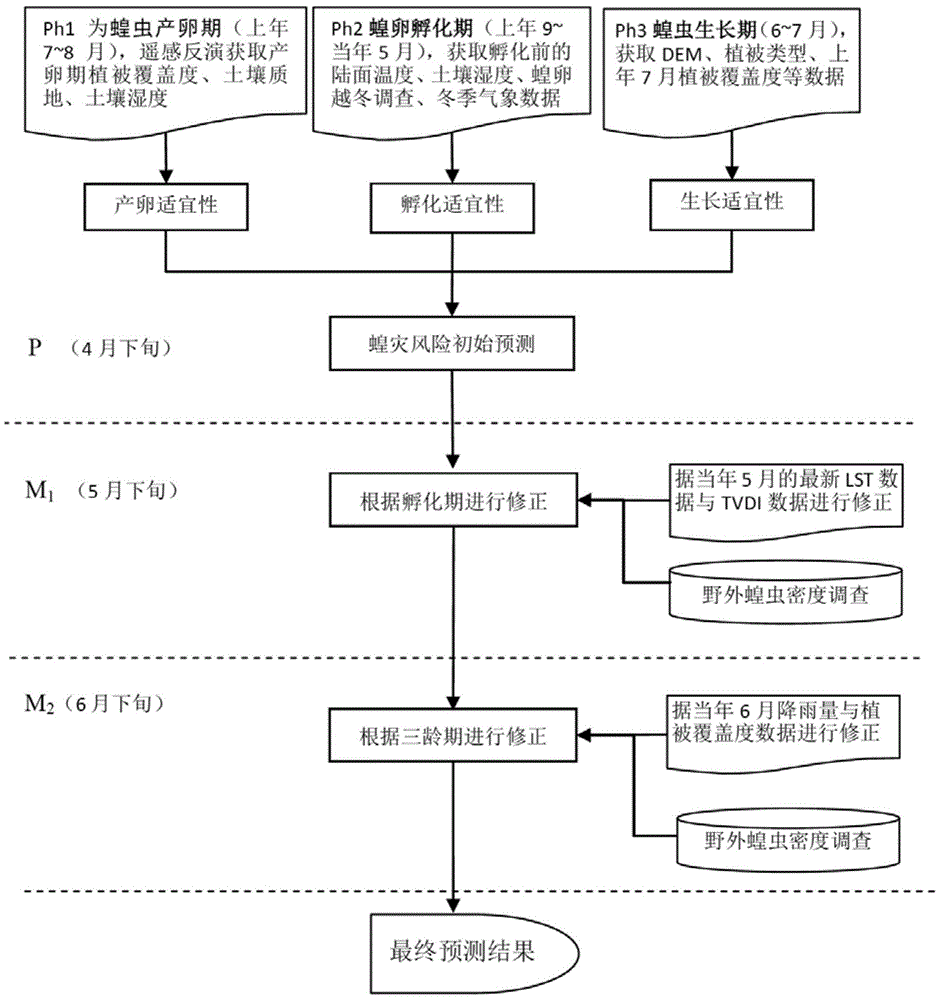
[0051] The present embodiment takes the Xinjiang region where grassland locust disasters frequently occur as an example, and adopts the progressive locust disaster risk prediction method provided by the present invention to carry out risk prediction on the locust disaster situation.

[0052] like figure 1 As shown, according to the interaction relationship between the development of the grassland locust population and the habitat elements, the present invention divides the development of the locust population into three stages: spawning stage, incubation stage and growth stage, as the basis for the construction of the locust disaster risk prediction model. These three stages are key to determining whether locust population development can ultimately constitute a disaster. B...


PUM


Abstract

The invention discloses a remote sensing technology-based grassland locust plague progressive prediction method. According to the method, the distribution of key habitat elements which influencing the development of a grassland locust population is obtained by the means of quantitative remote sensing inversion, meteorological station observation and the like, wherein the key habitat elements subjected to remote sensing inversion comprises land surface temperature, vegetation coverage and soil moisture; the spawning suitability, the incubation suitability and the growth suitability of locusts are analyzed quantitatively by establishing an evaluation model, and a locust plague risk early prediction model is established; a locust plague risk level prediction result is corrected by utilizing the remote sensing observation of an incubation period and a third period and the locust density data measured in the field according to the incubation and development time axes of the locusts, and the situations of a grassland locust plague are predicted progressively. According to the technical scheme provided by the invention, the progressive update of sensitive habitat elements is obtained by performing quantitative inversion on remote sensing data with higher time resolution, so that the prediction precision of a locust plague monitoring and prediction model is improved.

Description

technical field [0001] The present invention relates to the technical field of disaster prevention and control, earth observation and navigation, in particular to a method of using remote sensing and geographic information system technology to establish a progressive prediction method for grassland locust disasters in pastoral areas-agricultural areas according to the developmental stages of grassland locusts, which is a disaster monitoring method for grassland locust disasters And forecasting provides technical solutions with higher forecasting accuracy. Background technique [0002] For a long time, locust situation forecasting is considered to be one of the main tasks of grassland management departments and plant protection departments, and timely and effective locust disaster prevention and control is a very urgent task. However, my country's grassland area is very vast, mainly distributed in the northwest, north, and southern mountainous areas. The transportation is ext...

Claims


Application Information

Patent Timeline
Patent Type & Authority Patents(China)
IPC IPC(8): G06F19/00
Inventor 张显峰廖春华潘述铃
Owner PEKING UNIV
Features
  • R&D
  • Intellectual Property
  • Life Sciences
  • Materials
  • Tech Scout
  • Unparalleled Data Quality
  • Higher Quality Content
  • 60% Fewer Hallucinations
Learn More