Airborne Indoor Gas Remote Measurement System and Method
An indoor gas and telemetry system technology, applied in the field of photoelectric analysis, can solve problems such as inability to locate, depend on operator proficiency, complex structure, etc., and achieve the effect of reducing complexity and cost, improving maintainability, and expanding application fields.
- Summary
- Abstract
- Description
- Claims
- Application Information
AI Technical Summary
Problems solved by technology
Method used
Image


Examples
Embodiment 1
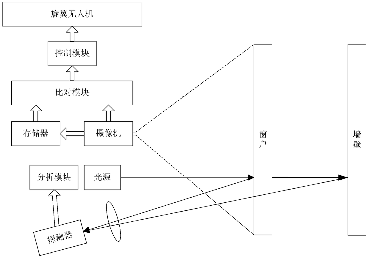
[0070] figure 1 The basic structural diagram of the airborne indoor gas telemetry system of the embodiment of the present invention is schematically given, as figure 1 As shown, the airborne indoor gas telemetry system includes:
[0071] Airborne positioning device, the airborne positioning device includes:
[0072] rotorcraft;
[0073] A video camera, the video camera is installed on the rotor UAV;
[0074] a memory, the memory is used to store the images transmitted by the camera;
[0075] Comparison module, the comparison module is used to compare images and templates, and the deviation is sent to the control module; the template is the image taken by the camera as a standard building window; the comparison module extracts the angle of the window in the image point (the corner extraction can use the Harris algorithm or other similar image feature extraction algorithms), compared with the corner point of the window in the template; if the position of the corner point in ...
Embodiment 2
[0103] An application example of the remote measurement system and method according to Embodiment 1 of the present invention in the detection of natural gas leakage in rooms on each floor of a residential building.
[0104]
[0105] During the operation of the telemetry system:
[0106] Positioning step: It is necessary to adjust the position of the multi-rotor UAV, and take a template image at a suitable detection position outside the window on the first floor of the building and store it;
[0107] The drone climbs to a certain height, which is approximately equal to the floor height of a building. The height of climb can be controlled by GPS, or an approximate height estimated by the operator. After the drone hovers, the camera it carries takes an image, and the software extracts the corner points of the windows on the image (the corner point extraction can use the Harris algorithm or other similar image feature extraction algorithms), and then compares it with the corne...
PUM
 Abstract
Description
Claims
Application Information
 - R&D
- Intellectual Property
- Life Sciences
- Materials
- Tech Scout
- Unparalleled Data Quality
- Higher Quality Content
- 60% Fewer Hallucinations
Browse by: Latest US Patents, China's latest patents, Technical Efficacy Thesaurus, Application Domain, Technology Topic, Popular Technical Reports.
© 2025 PatSnap. All rights reserved.Legal|Privacy policy|Modern Slavery Act Transparency Statement|Sitemap|About US| Contact US: help@patsnap.com