Unmanned plane electric power line patrol comprehensive geography information system

A technology of geographic information system and power line patrol, applied in satellite radio beacon positioning system, radio wave measurement system, signal transmission system, etc. Improve the effect of data information

Inactive Publication Date: 2016-10-12
GUANGDONG RONGQE INTELLIGENT TECH CO LTD
View PDF6 Cites 12 Cited by
  • Summary
  • Abstract
  • Description
  • Claims
  • Application Information

AI Technical Summary

Problems solved by technology

[0003] However, the data related to the geographical information database of the current power grid GIS system is not perfect. There are differences between some key location information and the actual data. The collected geographical information, visible light pictures, infrared temperature measurement data, ultraviolet da

Method used


Image

  • Unmanned plane electric power line patrol comprehensive geography information system

Examples


specific Embodiment approach

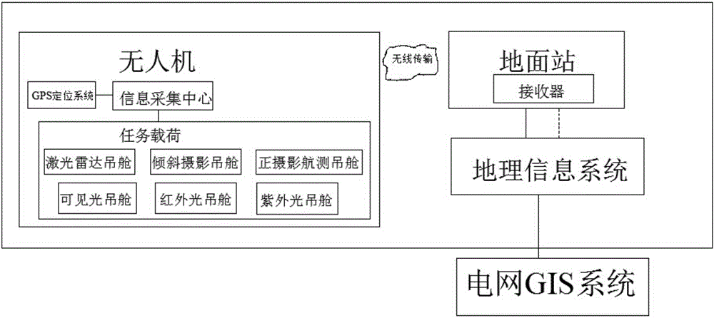
[0015] figure 1 A specific embodiment of the present invention is shown: a comprehensive geographic information system for unmanned aerial vehicle power line inspection, including an unmanned aerial vehicle, a ground station, a geographic information system, and a power grid GIS system. The unmanned aerial vehicle is connected to the ground station by wireless communication. The unmanned aerial vehicle is provided with an information collection center, a GPS positioning system and a mission load, and the mission load and the GPS positioning system are all connected with the information collection center, and the ground station is provided with a receiver, and the information collection center and the receiving The devices are connected by wireless communication, the ground station is connected to the geographic information system by wireless communication, and the geographic information system is connected to the power grid GIS system by wire.

[0016] In this embodiment, the ...


PUM


Abstract

The invention discloses an unmanned plane electric power line patrol comprehensive geography information system, relating to the unmanned plane field. The unmanned plane electric power line patrol comprehensive geography information system comprises an unmanned plane, an earth station, a geography information system and a power grid GIS system; the unmanned plane is in wireless communication connection with the earth station; the unmanned plane is provided with an information collection center, a GPS positioning system and a mission load; the mission load and the GPS positioning system are connected to the information collection center; the earth station is provided with a receiver; the information collection center is in wireless connection with the receiver; the earth station is in wireless communication connection with the geographic information system; and the geographic information system is in wired connection with the power grid GIS system. The technical scheme of the unmanned plane electric power line patrol comprehensive geography information system can completely and automatically analyze fault information of a failed point during the line patrol process through accurate plotting on the power line and iron rod geographic information by the unmanned plane and unmanned plane daily line patrol business, can well complete power grid GIS system data information and brings great convenience to monitoring and maintenance of the electric power line.

Description

technical field [0001] The invention relates to the field of unmanned aerial vehicles, in particular to an integrated geographical information system for electric line inspection of unmanned aerial vehicles. Background technique [0002] With the rapid development of the economy, the society's demand for electricity has surged, and the power lines are being greatly expanded. However, China has a vast territory, and the lines will pass through various complex terrain environments, thus promoting the emergence of UAV transmission line inspection methods. It It is a good solution to the problem of complex terrain transmission line inspection. However, long-distance field high-voltage transmission line inspections have very high safety requirements for UAV inspections, and image-based fault detection also relies on stable and reliable acquisition of image data. [0003] However, the data related to the geographical information database of the current power grid GIS system is no...

Claims


Application Information

Patent Timeline
IPC IPC(8): G01R31/08H02G1/02G01S17/89G01C11/00G01S19/14G08C17/02H04N7/18
CPCG01R31/085G01C11/00G01S17/89G01S19/14G08C17/02H02G1/02H04N7/181
Inventor 张力叶茂林
Owner GUANGDONG RONGQE INTELLIGENT TECH CO LTD
Why Eureka
Try Eureka