Supercharge Your Innovation With Domain-Expert AI Agents!

Projection-based regular grid terrain visual field calculation method

A calculation method and projection technology, applied in the field of visual domain analysis, can solve problems such as poor accuracy and high algorithm efficiency, and achieve the effects of high time efficiency, improved time efficiency, and reduced time complexity

Active Publication Date: 2018-03-30
CHINA UNIV OF MINING & TECH
View PDF3 Cites 2 Cited by
  • Summary
  • Abstract
  • Description
  • Claims
  • Application Information

AI Technical Summary

Problems solved by technology

This method is similar to the multiplexing inward closest point method, and the algorithm efficiency is high. For n x n The terrain grid has a time complexity of O ( n 2 ), but the accuracy is poor, it is an approximate method

Method used


Image

  • Projection-based regular grid terrain visual field calculation method
  • Projection-based regular grid terrain visual field calculation method
  • Projection-based regular grid terrain visual field calculation method

Examples


Embodiment Construction

[0039] The present invention will be further described in detail below in conjunction with specific examples.

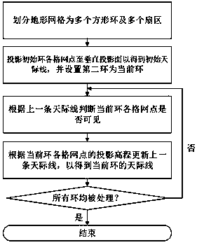
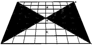
[0040] like Figure 1 to Figure 6 Shown is a projection-based method for calculating the visible domain of regular grid terrain, the specific implementation steps are as follows: the first step (refer to the attached figure 2 ), divide the terrain grid into 4 square rings with the viewpoint V as the center, and number them from the inside to the outside; then, use the diagonal of the outermost ring to divide all the rings into A, B, There are 4 fan-shaped areas in C and D; finally, a vertical projection surface is erected on the edge of the outermost ring, so that each fan-shaped area corresponds to a vertical projection surface.

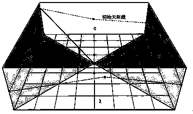
[0041] The second step (refer to the attached image 3 ), first project the 8 grid points of the first ring onto the 4 vertical projection planes respectively, and then connect the projection points on the 4 vertical projection planes i...


PUM


Abstract

The invention discloses a projection-based regular grid terrain visual field calculation method. The method comprises the steps of (1) performing square ring and sector division on a terrain grid, (2)projecting initial ring grid points to a vertical projection plane to calculate an initial skyline and setting a second ring as a current ring, (3) judging the visibility of each grid point of the current ring according to a previous skyline, (4) updating the previous skyline according to a projection elevation of each grid point of the current ring, and (5) viewing the updated skyline as a skyline corresponding to the current ring for the visibility judgment of subsequent ring grid points, and repeating steps (2), (3) and (4) until all rings are processed. According to the above method, occlusion information of each grid point in any ring is embodied on a latest skyline, sight line occlusion between a target point and a viewpoint is actually reflected based on the visibility judgment ofthe skyline, compared with an existing approximate calculation method or accurate calculation method, the method of the invention has the advantages of a more reliable result and higher time efficiency.

Description

technical field [0001] The patent of the present invention relates to the technical field of visual field analysis, in particular to a method for calculating the visible field of regular grid terrain based on projection. Background technique [0002] The field of view is the range that a specific observation point can see from the surrounding features, and it has important application value in practical problems such as facility site selection, landscape route planning, and security monitoring. In practical problem solving, the surrounding objects are often abstracted into a unified surface (such as terrain surface or urban surface), and this abstract surface is often represented by a regular grid. For this reason, the visible domain calculation is usually to find all the visible grid points relative to a certain viewpoint (namely, the observation point). In their monograph "Terrain Visibility Analysis and Application", Lu Pin and others summarized the calculation methods o...

Claims


Application Information

Patent Timeline
IPC IPC(8): G06T17/05G06T3/00
CPCG06T17/05G06T3/06
Inventor 余接情吴立新张绍良
Owner CHINA UNIV OF MINING & TECH
Features
  • R&D
  • Intellectual Property
  • Life Sciences
  • Materials
  • Tech Scout
  • Unparalleled Data Quality
  • Higher Quality Content
  • 60% Fewer Hallucinations
Learn More