Robot urban navigation system based on combination of visual SLAM and network map

A network map and navigation system technology, applied in control/adjustment systems, two-dimensional position/channel control, instruments, etc., can solve the problem that global path planning is no longer effective, limits accuracy and effectiveness, and wheeled robots cannot Navigation path traffic and other issues to achieve the effect of ensuring accuracy and traffic effectiveness

Active Publication Date: 2018-11-23
七腾机器人有限公司
View PDF14 Cites 22 Cited by
  • Summary
  • Abstract
  • Description
  • Claims
  • Application Information

AI Technical Summary

Problems solved by technology

[0004] However, global path planning can usually only be applied to environments with static obstacles or known environmental information
When the obstacles in the environment are constantly moving, or when an accurate prior map cannot be obtained in advance, global path planning will no longer work.
In addition, the global positioning system (Global Positioning System, GPS) used in global path planning will be helpless for indoor or obstacle-complex environments. In addition, it will not be able to obtain real-time positioning of the robot's traffic-level accuracy and provide environmental on-site obstacles. object information
These limitations limit the accuracy and effectiveness of relying solely on global path planning for path planning and navigation of wheeled robots, often resulting in the inability of wheeled robots to truly and effectively follow the navigation path

Method used


Image

  • Robot urban navigation system based on combination of visual SLAM and network map
  • Robot urban navigation system based on combination of visual SLAM and network map

Examples


Embodiment Construction

[0030] The robot city navigation system based on the combination of visual SLAM and network map of the present invention will be further described below in conjunction with the accompanying drawings and specific embodiments.

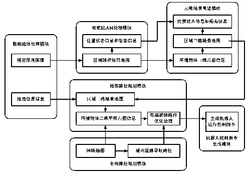
[0031] Such as figure 1 As shown, the present invention provides a robot city navigation system based on the combination of visual SLAM and network map. From the perspective of the overall system architecture, it includes a data communication processing module, a visual SLAM processing module, a three-dimensional scene reconstruction module, and a global path planning module. , a local path planning module and a robot control command generation module.

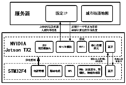
[0032] The data communication processing module is used to obtain the visual depth image collected by the binocular camera on the wheeled robot, and the geographic location information collected by the positioning sensor on the wheeled robot.

[0033] The visual SLAM processing module is used to perform...


PUM


Abstract

The invention provides a robot urban navigation system based on the combination of visual SLAM and a network map. The system performs the further local obstacle avoidance path optimization of an urbanroad navigation path with the help of the environment object space occupying condition, obtained through the SLAM processing, of a region where a wheel-type robot is located on the basis of an urbanroad navigation path that is determined through global path planning and along which the wheel-type robot in the network map arrives at a target place, thereby overcoming multiple technical limits anddefects of the navigation control of the wheel-type robot, only employing the global path planning, through the combination of the visual SLAM and the network map. The system can provide a finer positioning and path navigation for the wheel-type robot, and better guarantees that the wheel-type robot passes along the urban road navigation path after the local obstacle avoidance path optimization,and then better guarantees the path planning and navigation accuracy and passing effectiveness of the wheel-type robot.

Description

technical field [0001] The invention relates to the field of robot navigation path planning technology and visual SLAM processing technology, in particular to a robot city navigation system based on the combination of visual SLAM and network map. Background technique [0002] Navigation technology has always been a key research technology in the field of mobile robots. It is closely related to technologies such as robot positioning, 3D map reconstruction, and path planning. Among the hottest autonomous driving application technologies at present, the path planning and navigation of wheeled robots is an important technical component. Path planning refers to planning an optimal collision-free path from the starting point to the target point for a wheeled robot in an environment containing obstacles according to certain performance indicators or requirements. In the actual operation process, there are often problems such as a large amount of environmental information, rapid c...

Claims


Application Information

Patent Timeline
IPC IPC(8): G05D1/02
CPCG05D1/0214G05D1/0246G05D1/0274
Inventor 仲元红张钊源丁睿张顺黄关张静成欣雨周昭坤
Owner 七腾机器人有限公司
Why Eureka
Try Eureka