Supercharge Your Innovation With Domain-Expert AI Agents!

A wireless positioning base station layout method

A technology for wireless positioning base stations and base stations, which is applied to wireless communication, location-based services, electrical components, etc., and can solve problems such as algorithm adaptability decline, and achieve a flexible number of positioning base stations, visual search process, and fast search speed. Effect

Active Publication Date: 2020-10-27
SUN YAT SEN UNIV
View PDF7 Cites 0 Cited by
  • Summary
  • Abstract
  • Description
  • Claims
  • Application Information

AI Technical Summary

Problems solved by technology

At present, experts and scholars at home and abroad often determine the coordinate points of the base station layout first, and then evaluate the coverage and positioning accuracy of the base station layout algorithm. However, the environment for the algorithm implementation is mostly based on simple geometric space. environment, the adaptability of the algorithm will decline to a certain extent

Method used


Image

  • A wireless positioning base station layout method
  • A wireless positioning base station layout method
  • A wireless positioning base station layout method

Examples


Embodiment 1

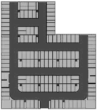
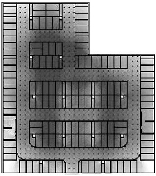
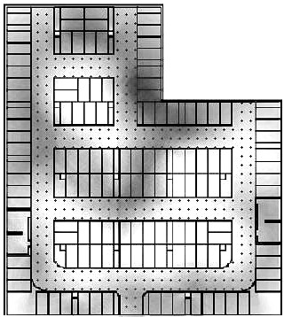
[0075] Such as Figure 1 to Figure 12 Shown is an embodiment of the wireless positioning base station deployment method of the present invention, including the following steps:

[0076] S10. Obtain the spatial structure information of the scene where the positioning service needs to be provided, and import it into the wireless positioning base station deployment system;

[0077] S20. Calculate the reverse radiation field, and delineate the base station deployment area based on the reverse radiation field;

[0078] S30. Use the mean value shift algorithm to find a point suitable for deploying base stations in step S20 in the reverse radiation field as a candidate point for new base station deployment, deploy base stations at the candidate points and calculate the current system score; if the system score after adding a base station If the system score is higher than the system score before the addition of the base station, continue to select candidate points to deploy the base...

Embodiment 2

[0167] In this embodiment, the method described in Embodiment 1 is used to calculate the system scores of the four wireless positioning methods of WiFi, Bluetooth, UWB, and RFID. Among them, the system construction cost factor, positioning effect factor, and interference reduction factor corresponding to the areas where WiFi, Bluetooth, UWB, and RFID four wireless positioning systems receive different numbers of non-interfering signals are shown in Table 2. WiFi, Bluetooth, UWB Table 3 shows the base station price coefficients of the four wireless positioning systems, RFID and RFID.

[0168] Table 2 Value table of scoring factors under different positioning signal numbers

[0169] N 0 1 2 3 4 5 6 F n

[0170] Table 3 Base station price coefficients of four positioning methods

[0171] Targeting Equipment market unit price Base station price coefficient C WiFi 150 1 Bluetooth 50 1 / 3 UWB 750 5 RFID 10 1 / 15

[0...


PUM


Abstract

The invention relates to the technical field of wireless communication, in particular to a wireless positioning base station layout method, which comprises the following steps: acquiring spatial structure information of a scene needing positioning service, and importing the spatial structure information into a wireless positioning base station layout system; calculating a reverse radiation field,and delineating a base station layout area by means of the reverse radiation field; using a mean shift algorithm to find a point suitable for arranging the base station as a candidate point for arranging the newly added base station, arranging the base station at the candidate point, and calculating a current system score; and displaying the wireless positioning base station layout result, and outputting the wireless positioning base station layout point position diagram. According to the invention, a base station arrangement area is defined by a reverse radiation field; and a multi-layer search mode is adopted, so that each newly added positioning base station layout point comprehensively considers the coordination and cooperation relationship with the existing base station, the signal quality of a single base station and the cooperation between base stations are considered, and the method has the characteristics of flexible positioning base station number, high search directivity, visual search process and high search speed.

Description

technical field [0001] The present invention relates to the technical field of wireless communication, and more specifically, to a method for laying out wireless positioning base stations. Background technique [0002] Radio Positioning Systems (Radio Positioning Systems) should be used for nautical ship navigation at the earliest to ensure the safety of navigation. With the advancement of positioning technology and the growing demand for positioning, radio positioning systems have been widely used in various fields, and have also driven other technological developments. The satellite radio positioning system represented by the GPS global positioning system is the positioning system with the widest coverage. Compared with the ground or indoor radio positioning system, the satellite radio positioning system is easily affected by the weather or tall buildings on the ground. It can't even be positioned indoors. Therefore, in the future development, when the demand for indoor ...

Claims


Application Information

Patent Timeline
Patent Type & Authority Patents(China)
IPC IPC(8): H04W4/02H04W16/18
CPCH04W4/02H04W16/18
Inventor 熊会元杨津铭金啸梁倍晔黄春婷
Owner SUN YAT SEN UNIV
Features
  • R&D
  • Intellectual Property
  • Life Sciences
  • Materials
  • Tech Scout
  • Unparalleled Data Quality
  • Higher Quality Content
  • 60% Fewer Hallucinations
Learn More