

Method for inverting cloud micro-physical parameters through thermal infrared remote sensing
A thermal infrared remote sensing and physical parameter technology, which is applied in the field of cloud parameter inversion of satellite remote sensing data, can solve the problem of inability to invert night cloud microphysical parameters, etc., and achieves the effects of fast calculation speed, wide application range and high precision
- Summary
- Abstract
- Description
- Claims
- Application Information
AI Technical Summary
Problems solved by technology
Method used
Image


Examples
Embodiment 1
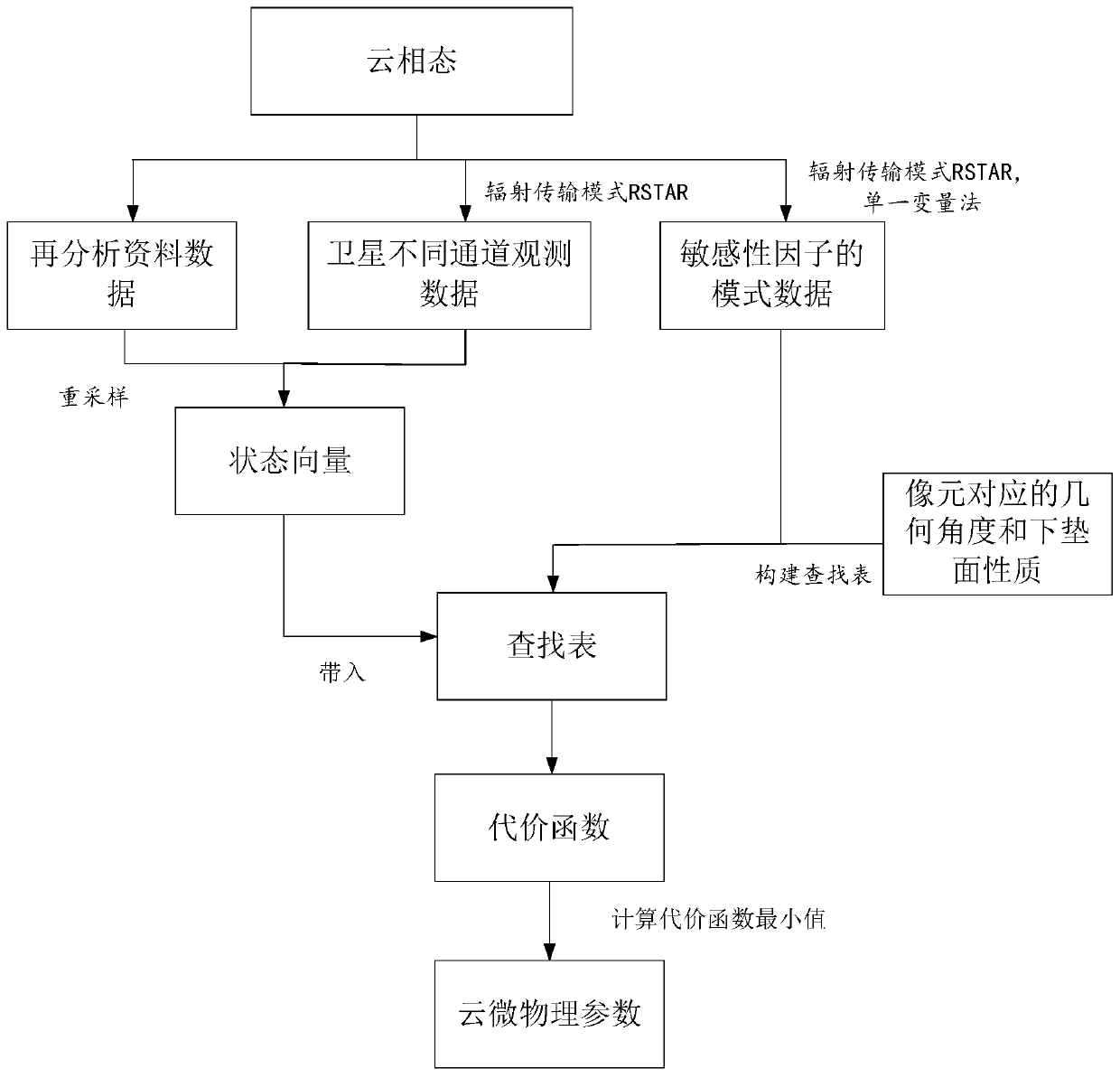
[0039] figure 2 It is a flowchart of a method for inverting cloud microphysical parameters by thermal infrared remote sensing.
[0040] The embodiment of the present application provides a method for inverting cloud microphysical parameters by thermal infrared remote sensing, comprising the following steps:
[0041] Step 101, using the radiative transfer model RSTAR to determine the sensitivity factors of the three channels of thermal infrared satellite channel data affecting cloud microphysical parameters.
[0042] The three channels are the three channels most sensitive to cloud microphysical parameters for satellites that obtain satellite channel data;
[0043] The thermal infrared satellite channel data is brightness temperature data, including the brightness temperature data of a single channel, and also includes the difference value of the brightness temperature data between channels. In the prior art, the visible light and near-infrared satellite channel data are ref...
Embodiment 2
[0070] image 3 It is a flow chart of another embodiment of the method for retrieving cloud microphysical parameters by thermal infrared remote sensing.
[0071] Step 101, using the radiative transfer model RSTAR to determine the sensitivity factors of thermal infrared satellite channel data affecting cloud microphysical parameters.
[0072] Step 102, selecting a plurality of typical band response function nodes on the band response function curve of the thermal infrared channel data as integration nodes.
[0073] The typical band response function node needs to achieve a dense satellite observation channel data integral value of 0.99.
[0074] Select several typical wavelengths on the band response function curve as the integration nodes to obtain the integration and the direct integration of the band response function of the satellite channel data. The similarity is greater than 0.99.
[0075] For example, the number of typical band response function nodes is about 30. In ...
Embodiment 3
[0080] Figure 4 It is a flow chart of the third embodiment of the method for retrieving cloud microphysical parameters for thermal infrared remote sensing.
[0081] Step 101, using the radiative transfer model RSTAR to determine the sensitivity factors of thermal infrared satellite channel data affecting cloud microphysical parameters.
[0082] Step 103, using the radiative transfer model RSTAR, simulating the sensitivity factor with a single variable method, and constructing a data set.
[0083] Step 104, according to the factor sensitivities of the sensitivity factors, use the data set to build a lookup table.
[0084] Step 105, resampling the reanalysis data according to the spatial resolution of the satellite channel data.
[0085] The purpose of the resampling is to make the horizontal resolution of the reanalysis data the same as that of the satellite channel data, so the reanalysis data can be resampled to make it have the same spatial resolution as the satellite cha...
PUM
 Abstract
Description
Claims
Application Information