Satellite ground communication station network topology visualization method and system
A communication site and satellite communication technology, applied in the field of satellite communication, can solve the problems of complex network maintenance, inconvenient operation and maintenance of satellite network sites, invisible ground communication sites, etc., to achieve the effect of facilitating monitoring and improving maintainability
- Summary
- Abstract
- Description
- Claims
- Application Information
AI Technical Summary
Problems solved by technology
Method used
Image

Examples
Embodiment 1
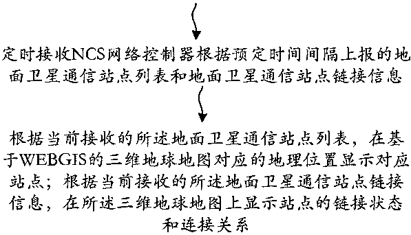
[0039] Such as figure 1 Shown is a flow chart of a network topology visualization method for satellite ground communication sites provided by this application, and its specific steps mainly include:
[0040] (1) Regularly receive the list of terrestrial satellite communication sites and the link information of terrestrial satellite communication sites reported by the NCS network controller according to the predetermined time interval.
[0041] Specifically, the ground satellite communication site list includes each site ID and corresponding geographic location information, and the ground satellite communication site link information includes the link status of each site and the connection relationship between each site.
[0042] Wherein, the geographic location information refers to the current geographic location information reported by each station through its own channel at a predetermined time interval and received regularly by the NCS network controller.
[0043] The cur...
Embodiment 2
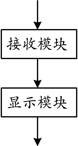
[0065] Such as figure 2 As shown, the application provides a structural block diagram of a network topology visualization system for satellite ground communication sites, which mainly includes: a receiving module and a display module.
[0066] The receiving module is configured to regularly receive the terrestrial satellite communication site list and the terrestrial satellite communication site link information reported by the NCS network controller according to a predetermined time interval.
[0067] Specifically, the ground satellite communication site list includes the name of each site and the corresponding geographic location information, and the ground satellite communication site link information includes the link status of each site and the connection relationship between the sites.
[0068] Geographic location information refers to the current geographic location information reported by each station through its own channel at a predetermined time interval received b...
Embodiment 3
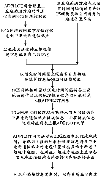
[0076] Such as image 3 As shown, the flow chart of another satellite ground communication site network topology visualization method provided by this application, the specific steps mainly include:
[0077] (1) The satellite ground communication station acquires its current geographic location information through its own GPS module at predetermined time intervals; in this example, every 4 seconds.
[0078] (2) The ADPILOT network management configures the channel information of the satellite ground communication station to the NCS network controller; the NCS network controller sends the channel information to the satellite ground communication station; the satellite ground communication station configures its own channel according to the channel information, and passes through its own channel Report the current geographic location information of itself to the NCS network controller at predetermined time intervals; in this step of this example, report once every 4 seconds.
...
PUM
 Abstract
Description
Claims
Application Information
 - Generate Ideas
- Intellectual Property
- Life Sciences
- Materials
- Tech Scout
- Unparalleled Data Quality
- Higher Quality Content
- 60% Fewer Hallucinations
Browse by: Latest US Patents, China's latest patents, Technical Efficacy Thesaurus, Application Domain, Technology Topic, Popular Technical Reports.
© 2025 PatSnap. All rights reserved.Legal|Privacy policy|Modern Slavery Act Transparency Statement|Sitemap|About US| Contact US: help@patsnap.com