
Low-altitude unmanned aerial vehicle self-positioning method based on vision and inertial navigation fusion

A positioning method and unmanned aerial vehicle technology, applied in navigation, surveying and mapping and navigation, navigation computing tools, etc., can solve the problems of high hardware cost, poor concealment ability, high brightness and texture requirements of input image data, and achieve reliable technical support, Effects that enhance applicability and accuracy

Pending Publication Date: 2021-01-05
NORTHWESTERN POLYTECHNICAL UNIV +1
View PDF7 Cites 5 Cited by
  • Summary
  • Abstract
  • Description
  • Claims
  • Application Information

AI Technical Summary

Problems solved by technology

Among them, due to the low cost and small size of the visual positioning method, especially after relying on the SLAM technology of the feature point method and the direct method, this method has achieved great development in the field of UAV positioning. The adaptability and calculation speed are stronger, but this method has a congenital defect, that is, it has higher requirements on the brightness and texture of the input image data; the laser positioning method adopts an active working mode, which can effectively avoid the high requirements of the visual sensor on the ambient light. problems, and can generate accurate 3D point clouds of scenes, which are widely used in the field of 3D reconstruction in closed spaces, but this method requires high hardware costs and poor concealment capabilities; multi-sensor fusion positioning can better solve single The problem that the sensor can only be applied to a single specific scene, give full play to the advantages of each sensor and form complementary data, thus greatly enhancing the applicability and accuracy of the positioning system, is also the main direction of research at this stage

Method used


Image

  • Low-altitude unmanned aerial vehicle self-positioning method based on vision and inertial navigation fusion
  • Low-altitude unmanned aerial vehicle self-positioning method based on vision and inertial navigation fusion
  • Low-altitude unmanned aerial vehicle self-positioning method based on vision and inertial navigation fusion

Examples


Embodiment Construction

[0021] Now in conjunction with embodiment, accompanying drawing, the present invention will be further described:

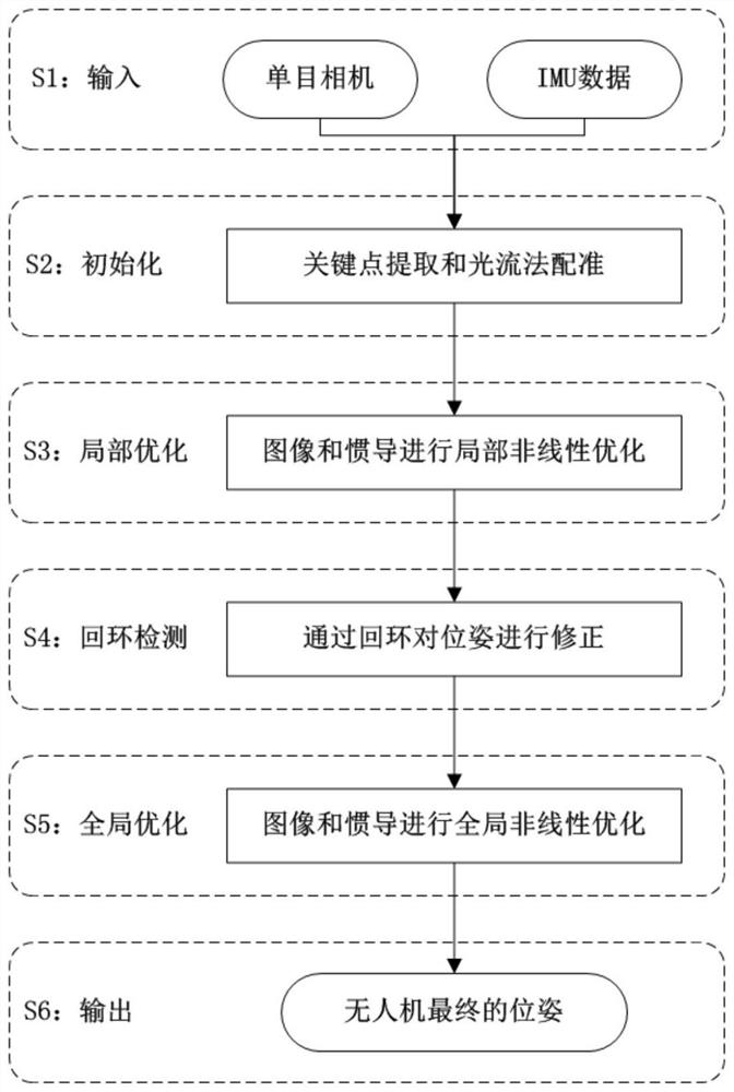
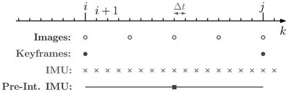
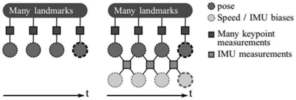
[0022] as attached figure 1 As shown, the present invention provides a self-positioning method for battlefield low-altitude UAVs based on fusion of vision and inertial navigation. First, the image frame collected by the monocular camera and the high-frequency data collected by the IMU module are used as input; then the key point extraction and optical flow method matching are performed on adjacent images, and the IMU data is pre-integrated to realize the initialization after the fusion of the image and the IMU Parameter estimation; then according to the image and inertial navigation information, the data of the local window is nonlinearly optimized to obtain preliminary pose information; then the current scene is judged through loop closure detection, and if there is a loop closure, the current frame and history are established using the bag of words model The l...


PUM


Abstract

The invention relates to a low-altitude unmanned aerial vehicle self-positioning method based on vision and inertial navigation fusion, which realizes complementation of sensor data by utilizing respective characteristics of a monocular camera and an IMU module. Although the monocular camera can adapt to most scenes being being applied to positioning, the scale problem cannot be solved, a matchingrelationship cannot be established in a weak texture scene and a rapid motion scene, and the problem of tracking loss is easy to occur; and the pure IMU can well reflect the dynamic change in a shorttime (millisecond), but the accumulative error of the pure IMU can be continuously increased in a long time (second). Therefore, in the stages of initialization, local optimization, global optimization and the like of the positioning process, advantage complementation among different sensors can be realized by fusing vision and inertial navigation information, the purpose of enhancing the applicability and accuracy of the positioning system is finally achieved, and reliable technical support is provided for self-positioning of the unmanned aerial vehicle in a battlefield low-altitude environment.

Description

technical field [0001] The invention belongs to the field of computer vision applications, and relates to a self-positioning method for a low-altitude unmanned aerial vehicle based on fusion of vision and inertial navigation. Background technique [0002] Due to the characteristics of high portability and strong mobility, drones are gradually playing an increasingly important role, and high-precision positioning and navigation capabilities are an important indicator to measure the performance of a drone system. An important link that embodies value in various fields. Under normal conditions, UAVs use integrated navigation methods such as GPS or Beidou to achieve their own positioning. However, due to the poor anti-interference ability of navigation signals and the weak signal strength in occluded environments, the problem of UAVs in the absence of satellite navigation signals is solved. The issue of self-positioning is very important. [0003] At present, the problem of po...

Claims


Application Information

Patent Timeline
IPC IPC(8): G01C21/16G01C21/20G06T7/269G06T7/70
CPCG01C21/165G01C21/20G06T7/269G06T7/70
Inventor 张通符文星陈康常晓飞张晓峰许涛付斌
Owner NORTHWESTERN POLYTECHNICAL UNIV
Features
  • Generate Ideas
  • Intellectual Property
  • Life Sciences
  • Materials
  • Tech Scout
  • Unparalleled Data Quality
  • Higher Quality Content
  • 60% Fewer Hallucinations
Learn More