
Solar Insolation Mapping Under Dense Forest Regions: Techniques
JUN 29, 20269 MIN READ
Generate Your Research Report Instantly with AI Agent
Patsnap Eureka helps you evaluate technical feasibility & market potential.
Solar Mapping Forest Canopy Challenges and Goals
Solar insolation mapping in dense forest environments represents one of the most complex challenges in renewable energy assessment and forest management applications. The intricate three-dimensional structure of forest canopies creates highly variable light conditions that traditional solar mapping techniques struggle to accurately capture and quantify.
The primary challenge stems from the dynamic nature of forest canopy architecture, where multiple layers of vegetation create complex shadowing patterns that change throughout the day and seasons. Dense forest regions typically exhibit canopy coverage exceeding 80%, with overlapping branches, varying leaf densities, and irregular gaps that create a heterogeneous light environment. This complexity makes it extremely difficult to predict solar radiation penetration using conventional two-dimensional mapping approaches.
Current limitations in existing solar mapping methodologies become particularly pronounced in forest environments. Satellite-based remote sensing techniques often fail to penetrate dense canopy layers, providing only surface-level irradiance data while missing crucial understory conditions. Ground-based measurement systems, while more accurate for specific locations, cannot efficiently cover large forest areas due to accessibility constraints and the prohibitive cost of establishing comprehensive sensor networks.
The technical objectives for advancing solar insolation mapping in dense forests focus on developing integrated multi-scale approaches that combine high-resolution remote sensing data with advanced modeling techniques. Key goals include achieving spatial resolution capabilities of less than one meter to capture canopy gap dynamics, implementing real-time temporal analysis to account for seasonal variations in leaf coverage, and establishing accuracy standards exceeding 85% for solar irradiance predictions at the forest floor level.
Advanced technological integration represents a critical pathway toward overcoming these challenges. The convergence of LiDAR technology, hyperspectral imaging, and machine learning algorithms offers promising solutions for creating detailed three-dimensional forest structure models. These integrated systems aim to generate comprehensive solar maps that account for both direct and diffuse radiation components while considering the complex light scattering effects caused by forest vegetation.
The ultimate goal involves developing standardized methodologies that can support diverse applications ranging from forest ecosystem research to renewable energy site assessment within forested landscapes, enabling more informed decision-making for sustainable forest management and solar energy deployment strategies.
The primary challenge stems from the dynamic nature of forest canopy architecture, where multiple layers of vegetation create complex shadowing patterns that change throughout the day and seasons. Dense forest regions typically exhibit canopy coverage exceeding 80%, with overlapping branches, varying leaf densities, and irregular gaps that create a heterogeneous light environment. This complexity makes it extremely difficult to predict solar radiation penetration using conventional two-dimensional mapping approaches.
Current limitations in existing solar mapping methodologies become particularly pronounced in forest environments. Satellite-based remote sensing techniques often fail to penetrate dense canopy layers, providing only surface-level irradiance data while missing crucial understory conditions. Ground-based measurement systems, while more accurate for specific locations, cannot efficiently cover large forest areas due to accessibility constraints and the prohibitive cost of establishing comprehensive sensor networks.
The technical objectives for advancing solar insolation mapping in dense forests focus on developing integrated multi-scale approaches that combine high-resolution remote sensing data with advanced modeling techniques. Key goals include achieving spatial resolution capabilities of less than one meter to capture canopy gap dynamics, implementing real-time temporal analysis to account for seasonal variations in leaf coverage, and establishing accuracy standards exceeding 85% for solar irradiance predictions at the forest floor level.
Advanced technological integration represents a critical pathway toward overcoming these challenges. The convergence of LiDAR technology, hyperspectral imaging, and machine learning algorithms offers promising solutions for creating detailed three-dimensional forest structure models. These integrated systems aim to generate comprehensive solar maps that account for both direct and diffuse radiation components while considering the complex light scattering effects caused by forest vegetation.
The ultimate goal involves developing standardized methodologies that can support diverse applications ranging from forest ecosystem research to renewable energy site assessment within forested landscapes, enabling more informed decision-making for sustainable forest management and solar energy deployment strategies.
Market Demand for Forest Solar Resource Assessment
The global forest management sector is experiencing unprecedented demand for accurate solar resource assessment technologies, driven by multiple converging factors that span environmental monitoring, renewable energy development, and precision forestry applications. Climate change mitigation strategies have elevated the importance of understanding solar radiation patterns within forested ecosystems, as these measurements directly impact carbon sequestration modeling, forest health monitoring, and biodiversity conservation planning.
Renewable energy developers are increasingly seeking opportunities to integrate solar installations within or adjacent to forested areas, creating substantial market demand for precise insolation mapping capabilities. This trend is particularly pronounced in regions where land availability for traditional solar farms is limited, necessitating innovative approaches to site selection and system design that account for complex canopy interactions and seasonal variations in solar penetration.
The precision forestry market represents another significant demand driver, where forest managers require detailed solar radiation data to optimize silvicultural practices, predict growth patterns, and implement selective harvesting strategies. Modern forest management increasingly relies on data-driven decision making, with solar insolation mapping serving as a critical input for forest productivity models and ecosystem service valuations.
Government agencies and environmental organizations are driving demand through regulatory requirements and conservation initiatives that mandate comprehensive forest monitoring programs. These organizations require standardized methodologies for assessing solar resources across diverse forest types, supporting policy development for land use planning and environmental impact assessments.
The carbon credit market has emerged as a substantial demand catalyst, where accurate solar radiation measurements are essential for validating forest carbon offset projects. Project developers need reliable insolation data to demonstrate additionality and quantify carbon sequestration rates, creating a growing market for specialized assessment services.
Research institutions and academic organizations contribute to market demand through ongoing studies investigating forest-atmosphere interactions, climate modeling, and ecosystem dynamics. These applications require high-resolution solar radiation datasets that can capture the complex spatial and temporal variability characteristic of dense forest environments.
The integration of solar resource assessment with emerging technologies such as precision agriculture and smart forestry systems is expanding market opportunities, as stakeholders seek comprehensive environmental monitoring solutions that can support multiple operational objectives simultaneously.
Renewable energy developers are increasingly seeking opportunities to integrate solar installations within or adjacent to forested areas, creating substantial market demand for precise insolation mapping capabilities. This trend is particularly pronounced in regions where land availability for traditional solar farms is limited, necessitating innovative approaches to site selection and system design that account for complex canopy interactions and seasonal variations in solar penetration.
The precision forestry market represents another significant demand driver, where forest managers require detailed solar radiation data to optimize silvicultural practices, predict growth patterns, and implement selective harvesting strategies. Modern forest management increasingly relies on data-driven decision making, with solar insolation mapping serving as a critical input for forest productivity models and ecosystem service valuations.
Government agencies and environmental organizations are driving demand through regulatory requirements and conservation initiatives that mandate comprehensive forest monitoring programs. These organizations require standardized methodologies for assessing solar resources across diverse forest types, supporting policy development for land use planning and environmental impact assessments.
The carbon credit market has emerged as a substantial demand catalyst, where accurate solar radiation measurements are essential for validating forest carbon offset projects. Project developers need reliable insolation data to demonstrate additionality and quantify carbon sequestration rates, creating a growing market for specialized assessment services.
Research institutions and academic organizations contribute to market demand through ongoing studies investigating forest-atmosphere interactions, climate modeling, and ecosystem dynamics. These applications require high-resolution solar radiation datasets that can capture the complex spatial and temporal variability characteristic of dense forest environments.
The integration of solar resource assessment with emerging technologies such as precision agriculture and smart forestry systems is expanding market opportunities, as stakeholders seek comprehensive environmental monitoring solutions that can support multiple operational objectives simultaneously.
Current Limitations of Solar Mapping in Dense Vegetation
Solar insolation mapping in dense vegetation environments faces significant technical and methodological constraints that limit the accuracy and reliability of current assessment approaches. Traditional remote sensing techniques encounter substantial challenges when attempting to penetrate forest canopies, as dense foliage creates complex light attenuation patterns that conventional sensors struggle to accurately quantify.
Satellite-based solar radiation models demonstrate reduced precision in heavily forested areas due to canopy interference and shadow effects. The heterogeneous nature of forest canopies creates irregular light transmission patterns that existing algorithms cannot adequately model. Current satellite imagery resolution often proves insufficient to capture the micro-scale variations in canopy density that significantly impact ground-level solar irradiance distribution.
Ground-based measurement networks face deployment and maintenance difficulties in dense forest environments. Physical accessibility constraints limit the strategic placement of pyranometers and other solar measurement instruments, resulting in sparse data coverage that inadequately represents the spatial variability of solar conditions beneath forest canopies. Equipment durability and calibration maintenance present ongoing operational challenges in harsh forest environments.
Existing computational models exhibit limitations in accurately simulating complex light scattering and absorption processes within multilayered forest canopies. Current radiative transfer models often oversimplify canopy architecture, failing to account for seasonal variations in leaf density, branch structure, and species-specific optical properties that influence solar penetration patterns.
Temporal resolution constraints affect the capture of dynamic solar conditions throughout daily and seasonal cycles. Many current mapping approaches rely on snapshot measurements or averaged data that fail to represent the temporal variability of solar availability under changing canopy conditions and sun angles.
Data integration challenges arise when attempting to combine multiple measurement sources and modeling approaches. Inconsistencies between different sensor types, measurement scales, and temporal sampling frequencies create difficulties in developing comprehensive solar insolation maps for dense forest regions. These limitations collectively restrict the development of accurate solar resource assessments necessary for renewable energy planning and forest management applications.
Satellite-based solar radiation models demonstrate reduced precision in heavily forested areas due to canopy interference and shadow effects. The heterogeneous nature of forest canopies creates irregular light transmission patterns that existing algorithms cannot adequately model. Current satellite imagery resolution often proves insufficient to capture the micro-scale variations in canopy density that significantly impact ground-level solar irradiance distribution.
Ground-based measurement networks face deployment and maintenance difficulties in dense forest environments. Physical accessibility constraints limit the strategic placement of pyranometers and other solar measurement instruments, resulting in sparse data coverage that inadequately represents the spatial variability of solar conditions beneath forest canopies. Equipment durability and calibration maintenance present ongoing operational challenges in harsh forest environments.
Existing computational models exhibit limitations in accurately simulating complex light scattering and absorption processes within multilayered forest canopies. Current radiative transfer models often oversimplify canopy architecture, failing to account for seasonal variations in leaf density, branch structure, and species-specific optical properties that influence solar penetration patterns.
Temporal resolution constraints affect the capture of dynamic solar conditions throughout daily and seasonal cycles. Many current mapping approaches rely on snapshot measurements or averaged data that fail to represent the temporal variability of solar availability under changing canopy conditions and sun angles.
Data integration challenges arise when attempting to combine multiple measurement sources and modeling approaches. Inconsistencies between different sensor types, measurement scales, and temporal sampling frequencies create difficulties in developing comprehensive solar insolation maps for dense forest regions. These limitations collectively restrict the development of accurate solar resource assessments necessary for renewable energy planning and forest management applications.
Existing Solutions for Canopy Penetration Solar Measurement
01 Satellite-based solar irradiance measurement systems
Advanced satellite systems equipped with specialized sensors are used to measure solar irradiance from space, providing comprehensive coverage for solar insolation mapping. These systems utilize multiple spectral bands and sophisticated algorithms to accurately assess solar radiation levels across large geographical areas. The satellite-based approach enables continuous monitoring and real-time data collection for improved mapping accuracy.- Satellite-based solar irradiance measurement systems: Advanced satellite systems equipped with specialized sensors are used to measure solar irradiance across large geographical areas. These systems utilize multiple spectral bands and atmospheric correction algorithms to provide accurate solar insolation data. The satellite-based approach enables comprehensive coverage of remote areas and provides consistent temporal resolution for mapping applications.
- Ground-based measurement and calibration techniques: Ground-based pyranometers and radiometers are deployed to collect reference solar irradiance measurements for calibration and validation purposes. These instruments provide high-precision point measurements that serve as ground truth data for satellite-derived estimates. The integration of multiple ground stations creates a network for continuous monitoring and accuracy assessment of solar mapping systems.
- Atmospheric modeling and correction algorithms: Sophisticated atmospheric models are employed to account for cloud cover, aerosols, water vapor, and other atmospheric constituents that affect solar radiation transmission. These correction algorithms process raw measurement data to compensate for atmospheric attenuation and scattering effects. Machine learning and statistical methods are integrated to improve the accuracy of atmospheric parameter estimation and solar irradiance calculations.
- Temporal and spatial interpolation methods: Advanced interpolation techniques are used to estimate solar irradiance values between measurement points and time intervals. Geostatistical methods and spatial analysis algorithms help create continuous solar maps from discrete measurement data. These methods consider topographical features, seasonal variations, and local climate patterns to enhance mapping accuracy across different temporal and spatial scales.
- Quality control and validation frameworks: Comprehensive quality assurance protocols are implemented to identify and correct erroneous data in solar insolation mapping systems. Statistical validation methods compare modeled results against independent measurement sources to assess accuracy and reliability. Automated quality control algorithms detect anomalies, instrument malfunctions, and data inconsistencies to maintain high standards of mapping precision.
02 Ground-based measurement and calibration techniques
Ground-based measurement stations and calibration systems are employed to validate and enhance the accuracy of solar insolation mapping. These systems use precision instruments and reference standards to provide accurate baseline measurements that can be used to calibrate satellite data and atmospheric models. The integration of ground-based measurements with remote sensing data significantly improves overall mapping precision.Expand Specific Solutions03 Atmospheric correction and modeling algorithms
Sophisticated atmospheric correction algorithms and modeling techniques are developed to account for atmospheric interference and scattering effects that impact solar radiation measurements. These methods compensate for cloud cover, aerosols, water vapor, and other atmospheric components that can affect the accuracy of solar insolation mapping. Advanced computational models process atmospheric data to provide more precise solar radiation estimates.Expand Specific Solutions04 Multi-sensor data fusion and integration methods
Data fusion techniques combine information from multiple sensors and measurement platforms to create more accurate and comprehensive solar insolation maps. These methods integrate satellite imagery, meteorological data, topographical information, and ground measurements using advanced algorithms. The multi-sensor approach reduces uncertainties and provides enhanced spatial and temporal resolution for solar mapping applications.Expand Specific Solutions05 Real-time processing and validation systems
Real-time data processing systems and validation frameworks are implemented to ensure continuous accuracy assessment and quality control of solar insolation mapping. These systems employ automated quality checks, statistical validation methods, and machine learning algorithms to detect and correct errors in real-time. The validation processes include cross-referencing with historical data and implementing feedback mechanisms to continuously improve mapping accuracy.Expand Specific Solutions
Key Players in Forest Solar Mapping and Remote Sensing
The solar insolation mapping under dense forest regions represents an emerging niche within the broader solar energy sector, currently in early development stages with significant technical challenges. The market remains relatively small but growing, driven by increasing demand for comprehensive renewable energy assessments in forested areas. Technology maturity varies considerably across stakeholders, with leading research institutions like MIT, Wuhan University, and Central South University advancing remote sensing and LiDAR-based methodologies, while forestry-specialized universities such as Southwest Forestry University and Nanjing Forestry University contribute domain expertise. Commercial players including TotalEnergies, Hanwha Q CELLS, and AES Corporation are beginning to integrate these techniques into broader solar development strategies, though practical implementation remains limited by computational complexity and data processing requirements for accurate canopy penetration analysis.
Korea Aerospace Research Institute
Technical Solution: KARI has developed satellite-based remote sensing techniques using synthetic aperture radar (SAR) and optical imagery fusion for forest canopy analysis and solar resource mapping. Their approach combines KOMPSAT satellite data with advanced image processing algorithms to estimate canopy height, density, and gap distribution patterns. The system utilizes polarimetric SAR data to penetrate forest canopies and assess understory characteristics, while optical sensors provide complementary information about canopy reflectance properties. Machine learning algorithms process multi-temporal satellite datasets to generate dynamic solar insolation maps accounting for seasonal canopy changes and phenological variations.
Strengths: Wide-area coverage capability, multi-sensor data fusion, operational satellite infrastructure. Weaknesses: Moderate spatial resolution limitations, complex data processing requirements, atmospheric interference effects.
Massachusetts Institute of Technology
Technical Solution: MIT has developed advanced LiDAR-based canopy penetration algorithms combined with machine learning models to estimate solar irradiance beneath forest canopies. Their approach integrates high-resolution airborne LiDAR data with multispectral imagery to create detailed 3D forest structure models, enabling accurate prediction of light transmission through complex canopy architectures. The system uses radiative transfer modeling coupled with Monte Carlo simulations to calculate photosynthetically active radiation (PAR) distribution at sub-canopy levels, achieving spatial resolutions of 1-2 meters.
Strengths: Highly accurate 3D modeling capabilities, strong computational resources, cutting-edge algorithm development. Weaknesses: High computational costs, requires expensive LiDAR equipment, limited scalability for large forest areas.
Core Innovations in LiDAR and Satellite Forest Mapping
Under-forest illumination intensity estimation method based on remote sensing
PatentInactiveCN107436193A
Innovation
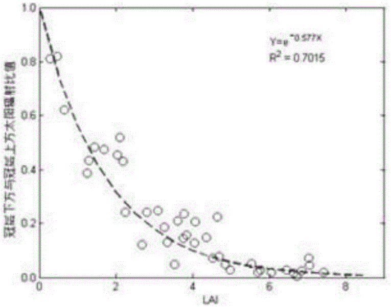
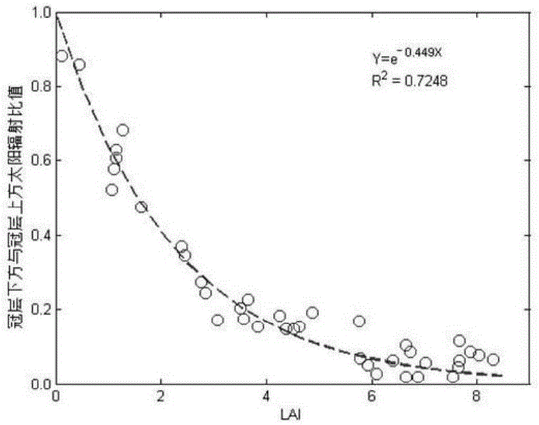
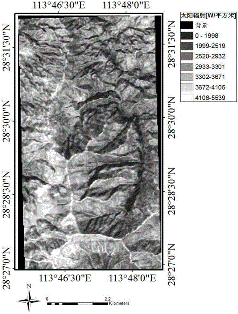
- A method based on remote sensing is used to determine the illumination-related parameters of the area to be measured, calculate the total solar radiation above the canopy, use satellite remote sensing images to invert the leaf area index, and calculate the understory illumination intensity based on the Beer-Lambert law to generate Regional scale light intensity spatiotemporal distribution map.

Large-range under-forest topographic mapping method and device based on low-frequency InSAR
PatentActiveCN119936880A
Innovation
- The method based on low-frequency InSAR is adopted to obtain the initial under-forest terrain through sub-aperture decomposition, pre-processing of interference maps, determining the under-forest terrain phase, unwrapping and phase height conversion, and a regional network adjustment model that takes into account the orbital system error and residual forest height error are constructed, and a large-scale under-forest terrain surveying and mapping products are generated.


Environmental Regulations for Forest Solar Development
The deployment of solar energy systems in forested areas operates within a complex regulatory framework that varies significantly across jurisdictions. At the federal level, the National Environmental Policy Act (NEPA) requires comprehensive environmental impact assessments for solar projects on public lands, while the Endangered Species Act mandates protection of critical habitats that may overlap with potential solar sites. These regulations establish baseline requirements for environmental compliance but often delegate specific implementation to state and local authorities.
State-level regulations typically focus on forest management practices and land use planning. Many states have enacted specific statutes governing renewable energy development in forested areas, including requirements for biodiversity impact assessments, soil erosion control measures, and restoration protocols. California's Forest Practice Act, for instance, establishes strict guidelines for tree removal and habitat preservation, while requiring detailed mitigation plans for any forest disturbance associated with solar installations.
Local zoning ordinances and municipal codes often present the most stringent requirements for forest solar development. These regulations frequently include setback requirements from water bodies, restrictions on slope development, and mandatory preservation of old-growth forest areas. Many jurisdictions require special use permits that involve extensive public consultation processes and detailed environmental monitoring plans.
International frameworks also influence domestic regulations, particularly through carbon credit mechanisms and sustainable development standards. The Forest Stewardship Council (FSC) certification requirements and similar international standards often become de facto regulatory requirements for projects seeking financing or carbon offset credits.
Compliance challenges arise from the intersection of multiple regulatory domains, including forestry, energy, environmental protection, and land use planning. Developers must navigate overlapping jurisdictions while ensuring adherence to both prescriptive technical standards and performance-based environmental outcomes. Recent regulatory trends indicate increasing emphasis on ecosystem services preservation and climate adaptation considerations in permitting processes.
State-level regulations typically focus on forest management practices and land use planning. Many states have enacted specific statutes governing renewable energy development in forested areas, including requirements for biodiversity impact assessments, soil erosion control measures, and restoration protocols. California's Forest Practice Act, for instance, establishes strict guidelines for tree removal and habitat preservation, while requiring detailed mitigation plans for any forest disturbance associated with solar installations.
Local zoning ordinances and municipal codes often present the most stringent requirements for forest solar development. These regulations frequently include setback requirements from water bodies, restrictions on slope development, and mandatory preservation of old-growth forest areas. Many jurisdictions require special use permits that involve extensive public consultation processes and detailed environmental monitoring plans.
International frameworks also influence domestic regulations, particularly through carbon credit mechanisms and sustainable development standards. The Forest Stewardship Council (FSC) certification requirements and similar international standards often become de facto regulatory requirements for projects seeking financing or carbon offset credits.
Compliance challenges arise from the intersection of multiple regulatory domains, including forestry, energy, environmental protection, and land use planning. Developers must navigate overlapping jurisdictions while ensuring adherence to both prescriptive technical standards and performance-based environmental outcomes. Recent regulatory trends indicate increasing emphasis on ecosystem services preservation and climate adaptation considerations in permitting processes.
Carbon Credit Integration with Forest Solar Assessment
The integration of carbon credit mechanisms with forest solar assessment represents a transformative approach to environmental monitoring and sustainable development. This convergence creates new opportunities for monetizing forest conservation efforts while simultaneously advancing renewable energy planning in forested regions. Carbon credit systems traditionally focus on quantifying carbon sequestration and storage capacity, but the incorporation of solar insolation mapping adds a crucial dimension for comprehensive land use optimization.
Forest ecosystems serve dual functions in climate mitigation strategies through both carbon sequestration and potential solar energy generation. The integration framework enables stakeholders to evaluate trade-offs between preserving forest canopy for carbon storage versus selective clearing for solar installations. This assessment methodology considers canopy density variations, species composition, and growth rates alongside solar irradiance potential to determine optimal land management strategies.
Advanced remote sensing technologies facilitate the simultaneous measurement of both carbon storage indicators and solar resource availability. Satellite-based LiDAR systems can quantify biomass density while hyperspectral imaging assesses canopy gaps suitable for solar installations. These integrated datasets enable the development of comprehensive valuation models that account for both carbon credit revenues and solar energy potential.
The economic modeling framework incorporates carbon price volatility, renewable energy certificates, and long-term forest management costs. Machine learning algorithms analyze historical carbon market data alongside solar irradiance patterns to predict optimal intervention timing and spatial distribution. This approach enables forest managers to maximize combined revenue streams while maintaining ecological integrity.
Regulatory frameworks increasingly recognize the interconnected nature of carbon sequestration and renewable energy development. Emerging policy structures provide incentives for integrated approaches that balance forest conservation with clean energy generation. These mechanisms often include tiered carbon credit systems that reward sustainable solar development practices within forested landscapes.
Implementation challenges include standardizing measurement protocols across different forest types and establishing verification procedures for integrated assessment claims. Blockchain-based tracking systems show promise for transparent monitoring of both carbon sequestration rates and solar energy production metrics, ensuring accountability in combined credit systems.
Forest ecosystems serve dual functions in climate mitigation strategies through both carbon sequestration and potential solar energy generation. The integration framework enables stakeholders to evaluate trade-offs between preserving forest canopy for carbon storage versus selective clearing for solar installations. This assessment methodology considers canopy density variations, species composition, and growth rates alongside solar irradiance potential to determine optimal land management strategies.
Advanced remote sensing technologies facilitate the simultaneous measurement of both carbon storage indicators and solar resource availability. Satellite-based LiDAR systems can quantify biomass density while hyperspectral imaging assesses canopy gaps suitable for solar installations. These integrated datasets enable the development of comprehensive valuation models that account for both carbon credit revenues and solar energy potential.
The economic modeling framework incorporates carbon price volatility, renewable energy certificates, and long-term forest management costs. Machine learning algorithms analyze historical carbon market data alongside solar irradiance patterns to predict optimal intervention timing and spatial distribution. This approach enables forest managers to maximize combined revenue streams while maintaining ecological integrity.
Regulatory frameworks increasingly recognize the interconnected nature of carbon sequestration and renewable energy development. Emerging policy structures provide incentives for integrated approaches that balance forest conservation with clean energy generation. These mechanisms often include tiered carbon credit systems that reward sustainable solar development practices within forested landscapes.
Implementation challenges include standardizing measurement protocols across different forest types and establishing verification procedures for integrated assessment claims. Blockchain-based tracking systems show promise for transparent monitoring of both carbon sequestration rates and solar energy production metrics, ensuring accountability in combined credit systems.
Unlock deeper insights with Patsnap Eureka Quick Research — get a full tech report to explore trends and direct your research. Try now!
Generate Your Research Report Instantly with AI Agent
Supercharge your innovation with Patsnap Eureka AI Agent Platform!