Solid-State Lidar vs Volumetric Scanners: Better for Terrain Mapping?
APR 27, 20269 MIN READ
Generate Your Research Report Instantly with AI Agent
PatSnap Eureka helps you evaluate technical feasibility & market potential.
Solid-State LiDAR vs Volumetric Scanner Background and Objectives
The evolution of terrain mapping technologies has been fundamentally shaped by the continuous advancement of remote sensing capabilities. Traditional surveying methods, while accurate, proved time-consuming and labor-intensive for large-scale terrain analysis. The introduction of LiDAR technology in the 1960s marked a revolutionary shift, initially utilizing mechanical scanning systems that provided unprecedented three-dimensional mapping capabilities. However, these early systems were bulky, expensive, and limited in their operational flexibility.
The development trajectory of terrain mapping has consistently pursued higher resolution, faster data acquisition, and improved operational efficiency. Solid-state LiDAR emerged as a breakthrough technology, eliminating mechanical components through electronic beam steering and solid-state components. This innovation addressed critical limitations of traditional rotating LiDAR systems, including mechanical wear, vibration sensitivity, and size constraints. Simultaneously, volumetric scanning technologies evolved to capture comprehensive three-dimensional data through advanced sensor fusion and multi-perspective imaging techniques.
Current terrain mapping applications demand increasingly sophisticated solutions capable of operating in diverse environmental conditions while maintaining centimeter-level accuracy. Applications span from autonomous vehicle navigation and urban planning to geological surveys and infrastructure monitoring. The growing emphasis on real-time processing and mobile deployment has intensified the need for compact, robust, and cost-effective mapping solutions.
The primary objective of comparing solid-state LiDAR and volumetric scanners centers on identifying optimal technologies for specific terrain mapping scenarios. Key evaluation criteria include spatial resolution, data acquisition speed, operational range, environmental adaptability, and cost-effectiveness. Understanding the fundamental differences between these technologies enables informed decision-making for various applications, from precision agriculture to disaster response mapping.
This technological assessment aims to establish clear performance benchmarks and application-specific recommendations. The analysis focuses on quantifying advantages and limitations of each approach, considering factors such as point cloud density, measurement accuracy, power consumption, and integration complexity. The ultimate goal involves providing strategic guidance for technology selection based on specific terrain mapping requirements and operational constraints.
Market Demand Analysis for Advanced Terrain Mapping Solutions
The global terrain mapping market is experiencing unprecedented growth driven by diverse industry applications requiring high-precision spatial data. Autonomous vehicle development represents one of the most significant demand drivers, as manufacturers require detailed three-dimensional environmental mapping for safe navigation systems. The construction and infrastructure sectors increasingly rely on accurate terrain data for project planning, site analysis, and progress monitoring, particularly in large-scale developments where traditional surveying methods prove insufficient.
Mining operations constitute another substantial market segment, utilizing advanced terrain mapping for resource exploration, safety monitoring, and operational optimization. The technology enables real-time monitoring of excavation sites, slope stability analysis, and volumetric calculations essential for efficient resource extraction. Similarly, the oil and gas industry leverages terrain mapping for pipeline route planning, environmental impact assessment, and facility site selection in challenging geographical locations.
Urban planning and smart city initiatives are driving significant demand for comprehensive terrain mapping solutions. Municipal governments require detailed topographical data for flood risk assessment, zoning decisions, and infrastructure development planning. The integration of terrain mapping with geographic information systems has become essential for modern urban development strategies.
The defense and security sector represents a critical market segment, utilizing terrain mapping for mission planning, border surveillance, and strategic asset protection. Military applications demand high-resolution, real-time mapping capabilities that can operate effectively in diverse environmental conditions and provide tactical advantages in complex terrains.
Environmental monitoring and climate research applications are expanding rapidly, with organizations requiring precise terrain data for ecosystem analysis, deforestation tracking, and natural disaster assessment. The growing emphasis on environmental sustainability and climate change mitigation has increased demand for continuous, accurate terrain monitoring solutions.
Market growth is further accelerated by technological convergence trends, where terrain mapping integrates with artificial intelligence, machine learning, and cloud computing platforms. This integration enables automated data processing, predictive analytics, and real-time decision-making capabilities that enhance operational efficiency across multiple industries.
The increasing adoption of unmanned aerial vehicles and robotic systems across various sectors has created substantial demand for compact, efficient terrain mapping technologies. These applications require solutions that balance accuracy, processing speed, and power consumption while maintaining reliability in challenging operational environments.
Current Status and Challenges in LiDAR Terrain Mapping
LiDAR technology has achieved significant maturity in terrain mapping applications, with both solid-state LiDAR and volumetric scanners demonstrating distinct capabilities across various operational environments. Current solid-state systems typically operate at wavelengths of 905nm or 1550nm, offering compact form factors and enhanced reliability due to the absence of mechanical rotating components. These systems achieve point cloud densities ranging from 100,000 to 2 million points per second, with effective ranges extending up to 200 meters for terrain mapping applications.
Volumetric scanning systems, predominantly mechanical LiDAR units, continue to dominate high-precision terrain mapping markets due to their superior angular resolution and 360-degree field of view capabilities. These systems generate point clouds with densities exceeding 1 million points per second and maintain measurement accuracies within 2-3 centimeters at ranges up to 300 meters. However, their mechanical complexity introduces reliability concerns in harsh environmental conditions.
The primary technical challenge facing both technologies centers on data processing and real-time terrain reconstruction. Current algorithms struggle with vegetation filtering, ground point classification, and slope analysis in complex topographical environments. Processing latencies for high-density point clouds often exceed acceptable thresholds for real-time applications, particularly in autonomous vehicle navigation and dynamic surveying scenarios.
Environmental adaptability remains a critical limitation across both platforms. Atmospheric conditions, including fog, rain, and dust, significantly degrade performance, with solid-state systems showing particular sensitivity to weather-related interference. Temperature variations affect laser stability and ranging accuracy, while reflectivity variations in terrain surfaces create inconsistent data quality across different geological compositions.
Power consumption and thermal management present ongoing challenges, especially for mobile and airborne applications. Solid-state systems typically consume 15-30 watts, while mechanical scanners require 40-80 watts, impacting deployment duration and system integration complexity. Geographic distribution of advanced LiDAR terrain mapping capabilities remains concentrated in North America, Europe, and East Asia, with emerging markets showing increasing adoption rates.
Integration challenges persist in multi-sensor fusion architectures, where LiDAR data must be synchronized with GPS, IMU, and camera systems for comprehensive terrain analysis. Current solutions often suffer from temporal misalignment and coordinate system transformation errors, affecting overall mapping accuracy and reliability in demanding applications.
Current Technical Solutions for High-Precision Terrain Mapping
01 Solid-state LiDAR sensor technology and beam steering mechanisms
Advanced solid-state LiDAR systems utilize sophisticated beam steering mechanisms and sensor arrays to achieve high-resolution terrain mapping without mechanical moving parts. These systems employ optical phased arrays, MEMS mirrors, and electronic beam steering to provide reliable and compact scanning solutions for terrain analysis. The technology focuses on improving scanning accuracy, reducing power consumption, and enhancing durability for various environmental conditions.- Solid-state LiDAR sensor technology and beam steering mechanisms: Advanced solid-state LiDAR systems utilize sophisticated beam steering mechanisms and sensor arrays to achieve high-resolution terrain mapping without mechanical moving parts. These systems employ optical phased arrays, MEMS mirrors, or flash LiDAR technology to electronically control beam direction and scanning patterns. The solid-state approach provides improved reliability, reduced size, and enhanced durability for terrain mapping applications while maintaining precise distance measurements and point cloud generation capabilities.
- Volumetric scanning algorithms and 3D point cloud processing: Volumetric scanning systems implement advanced algorithms for processing three-dimensional point cloud data to create detailed terrain maps. These methods involve sophisticated data processing techniques for filtering, clustering, and interpolating LiDAR measurements to generate accurate volumetric representations of terrain features. The algorithms handle large datasets efficiently while preserving spatial accuracy and enabling real-time terrain analysis for various applications including autonomous navigation and surveying.
- Multi-sensor fusion and data integration techniques: Integration of multiple sensing modalities combines LiDAR data with other sensor inputs such as cameras, IMU, and GPS to enhance terrain mapping accuracy and robustness. These fusion techniques employ advanced algorithms to correlate and synchronize data from different sources, improving overall system performance in challenging environmental conditions. The integrated approach provides comprehensive terrain characterization by leveraging the complementary strengths of various sensing technologies.
- Real-time terrain mapping and obstacle detection systems: Real-time processing capabilities enable immediate terrain analysis and obstacle detection for dynamic applications such as autonomous vehicles and robotics. These systems implement optimized computational architectures and parallel processing techniques to handle high-frequency LiDAR data streams while maintaining low latency. The real-time approach supports immediate decision-making and path planning based on current terrain conditions and detected obstacles.
- Performance optimization and calibration methods for terrain mapping accuracy: Calibration and performance optimization techniques ensure maximum accuracy and reliability of LiDAR-based terrain mapping systems. These methods include systematic error correction, environmental compensation algorithms, and adaptive parameter tuning to maintain consistent performance across varying operational conditions. The optimization approaches address factors such as atmospheric effects, surface reflectivity variations, and system drift to achieve precise terrain measurements and mapping fidelity.
02 3D point cloud processing and terrain reconstruction algorithms
Sophisticated algorithms are employed to process volumetric scan data and reconstruct detailed three-dimensional terrain models from LiDAR point clouds. These processing methods include noise filtering, surface interpolation, and feature extraction techniques that convert raw sensor data into accurate topographical representations. The algorithms optimize computational efficiency while maintaining high precision in terrain mapping applications.Expand Specific Solutions03 Multi-sensor fusion and data integration systems
Integration of multiple sensing modalities combines LiDAR data with other sensor inputs such as cameras, IMUs, and GPS to enhance terrain mapping accuracy and reliability. These fusion systems employ advanced calibration techniques and synchronization methods to merge heterogeneous data sources into comprehensive terrain models. The approach improves mapping performance in challenging environments and provides redundancy for critical applications.Expand Specific Solutions04 Real-time terrain mapping and navigation applications
Real-time processing capabilities enable immediate terrain analysis and mapping for autonomous navigation and obstacle avoidance systems. These implementations focus on low-latency data processing, efficient memory management, and optimized computational architectures to support dynamic terrain mapping in mobile platforms. The systems provide continuous environmental awareness for robotics, automotive, and aerospace applications.Expand Specific Solutions05 Performance optimization and calibration methodologies
Comprehensive calibration and performance optimization techniques ensure accurate and consistent terrain mapping results across different operational conditions. These methodologies include systematic error correction, environmental compensation, and adaptive parameter tuning to maintain mapping precision. The approaches address various factors affecting measurement accuracy such as atmospheric conditions, surface reflectivity, and system aging effects.Expand Specific Solutions
Major Players in LiDAR and Volumetric Scanning Industry
The solid-state LiDAR versus volumetric scanners terrain mapping sector represents a rapidly evolving market in the growth phase, driven by autonomous vehicle development and advanced sensing applications. The industry demonstrates significant scale potential with established players like Ouster Technologies, Hesai Technology, and RoboSense leading commercialization efforts alongside emerging innovators such as Lumotive and Seyond developing next-generation solid-state solutions. Technology maturity varies considerably across the competitive landscape, with companies like Samsung Electronics and research institutions including SRI International and German Aerospace Center advancing fundamental technologies, while specialized firms like Opsys Tech and Zendar focus on application-specific implementations. The market shows strong consolidation trends as traditional automotive suppliers and tech giants invest heavily in LiDAR capabilities for terrain mapping applications.
Ouster Technologies, Inc.
Technical Solution: Ouster develops digital lidar sensors using solid-state technology with spinning multi-beam arrays that provide 360-degree field of view coverage. Their OS-series sensors deliver high-resolution 3D point clouds with up to 2.5 million points per second and ranges up to 240 meters, specifically optimized for terrain mapping applications. The sensors feature uniform angular resolution and high vertical resolution of up to 128 channels, enabling detailed surface reconstruction and topographical analysis. Their digital architecture provides superior signal processing capabilities compared to analog systems, with built-in calibration and environmental compensation for consistent performance across varying conditions.
Strengths: High resolution point clouds, robust environmental performance, digital signal processing. Weaknesses: Higher cost compared to mechanical alternatives, limited range compared to some volumetric scanners.
Hesai Technology Co. Ltd.
Technical Solution: Hesai specializes in hybrid solid-state lidar systems that combine mechanical and solid-state elements for terrain mapping applications. Their PandarXT series offers 32-channel scanning with 200-meter detection range and precise angular resolution of 0.18° horizontal and 0.33° vertical. The technology utilizes advanced signal processing algorithms for ground point classification and terrain feature extraction, making it particularly suitable for autonomous vehicle navigation and surveying applications. Their systems incorporate adaptive scanning patterns that can adjust beam density based on terrain complexity, optimizing data collection efficiency for mapping purposes.
Strengths: Adaptive scanning capabilities, proven automotive-grade reliability, competitive pricing. Weaknesses: Hybrid design complexity, potential mechanical wear components, moderate resolution compared to pure solid-state solutions.
Core Technology Analysis of Solid-State vs Volumetric Approaches
Three-dimensional-mapping two-dimensional-scanning lidar based on one-dimensional-steering optical phased arrays and method of using same
PatentActiveUS20180136317A1
Innovation
- A two-dimensional scanning solid-state lidar is achieved using a plurality of one-dimensional planar beam forming and steering optical phased array chips, which are simpler and more cost-effective, utilizing Photonic Integrated Circuits with tunable optical delay lines and optical antennas to steer laser beams.


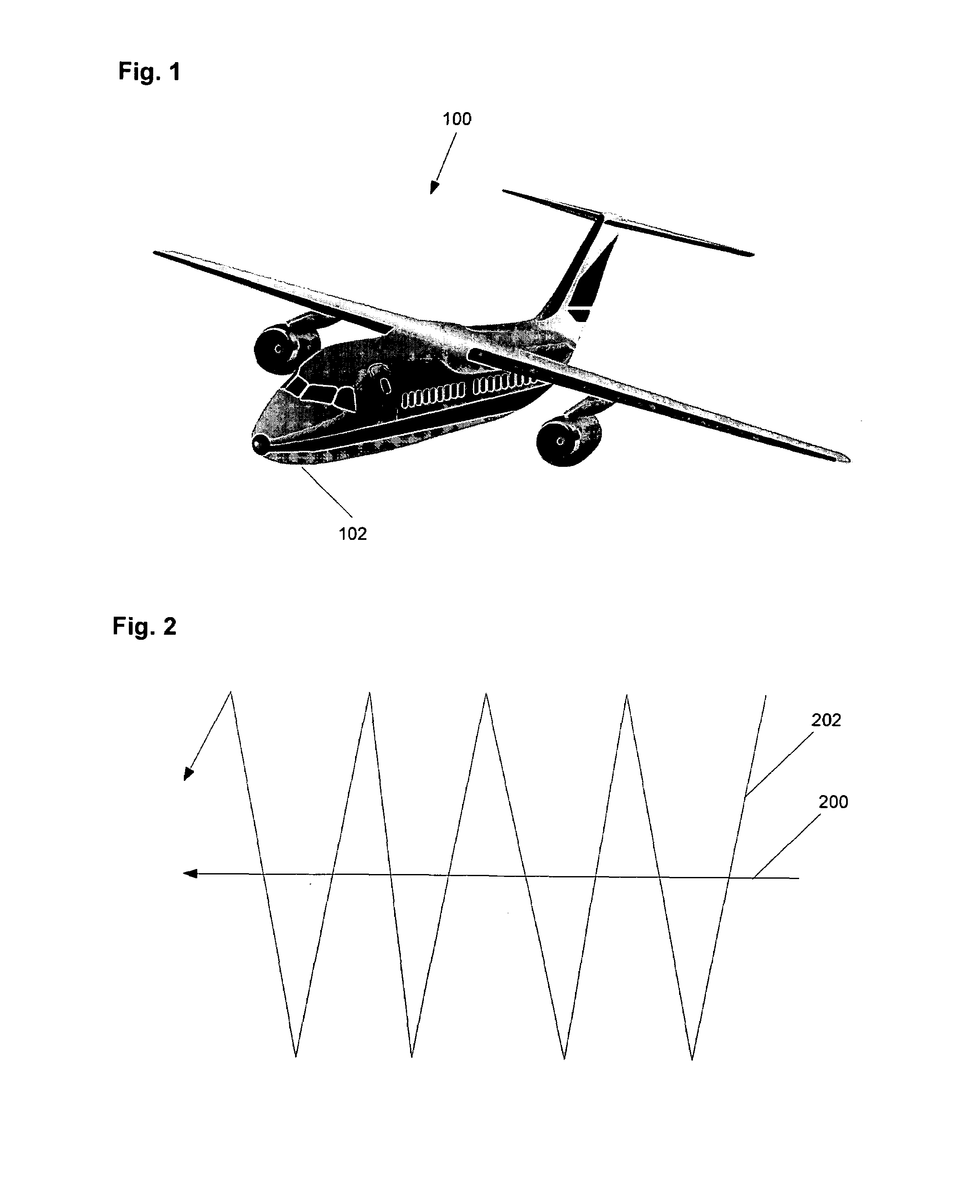
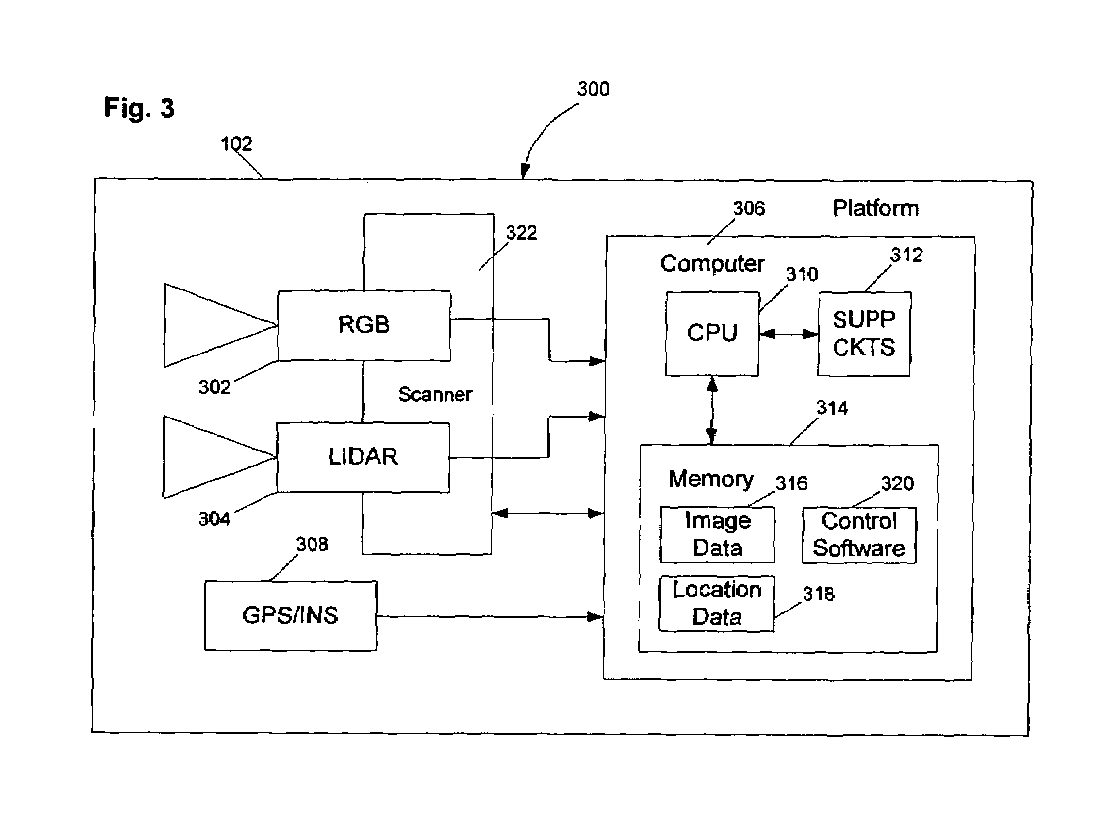
Method and apparatus for performing wide area terrain mapping
PatentInactiveUS7363157B1
Innovation
- A system that integrates a digital elevation map (DEM) and mosaic generation engine to process simultaneous data from an electro-optical camera and a LIDAR sensor mounted on an aerial platform, allowing for geometrically accurate three-dimensional terrain mapping by aligning the camera and LIDAR sensor and using GPS/INS data for metadata, enabling efficient data processing and integration.


Safety Standards and Regulations for LiDAR Systems
The regulatory landscape for LiDAR systems in terrain mapping applications encompasses multiple jurisdictional frameworks that vary significantly between solid-state LiDAR and volumetric scanning technologies. International standards organizations, including the International Electrotechnical Commission (IEC) and the International Organization for Standardization (ISO), have established foundational safety protocols that govern laser emission limits, electromagnetic compatibility, and operational safety requirements for both technology categories.
Laser safety regulations represent the most critical regulatory consideration, with IEC 60825-1 defining classification standards for laser products used in LiDAR systems. Solid-state LiDAR units typically operate within Class 1 or Class 1M safety classifications, allowing for more flexible deployment scenarios with reduced safety infrastructure requirements. Volumetric scanners, particularly those employing higher-power laser sources for extended range capabilities, may require Class 3R or Class 3B classifications, necessitating additional safety measures including restricted access zones and specialized operator training protocols.
Aviation regulatory bodies, including the Federal Aviation Administration (FAA) and European Union Aviation Safety Agency (EASA), impose specific constraints on airborne LiDAR operations for terrain mapping. These regulations address flight altitude restrictions, pilot certification requirements, and equipment certification standards that directly impact the selection between solid-state and volumetric scanning solutions. Solid-state systems often benefit from reduced regulatory complexity due to their compact form factors and lower power consumption profiles.
Environmental protection regulations increasingly influence LiDAR deployment strategies, particularly in ecologically sensitive terrain mapping applications. Wildlife protection standards may restrict certain scanning frequencies or operational timeframes, while electromagnetic interference regulations ensure compatibility with existing communication and navigation systems. Volumetric scanners with their broader spectral capabilities may face additional scrutiny under these environmental frameworks.
Data privacy and security regulations, including the General Data Protection Regulation (GDPR) and various national security frameworks, establish requirements for data collection, processing, and storage in terrain mapping operations. These regulations impact both technology categories equally but may influence system architecture decisions regarding onboard processing capabilities versus cloud-based data handling approaches.
Cost-Benefit Analysis of LiDAR vs Volumetric Solutions
The economic evaluation of solid-state LiDAR versus volumetric scanning solutions for terrain mapping reveals significant differences in both initial investment requirements and operational expenditures. Solid-state LiDAR systems typically demand higher upfront capital costs, ranging from $50,000 to $200,000 per unit for high-precision terrain mapping applications. However, these systems offer substantial long-term value through reduced maintenance requirements, extended operational lifespans exceeding 10,000 hours, and minimal moving parts that decrease failure rates.
Volumetric scanning solutions present a more accessible entry point with initial costs ranging from $15,000 to $80,000, making them attractive for organizations with limited budgets or pilot projects. The lower barrier to entry enables broader adoption across smaller surveying firms and research institutions. However, the total cost of ownership often escalates due to higher maintenance frequencies, calibration requirements, and shorter equipment lifecycles.
Operational efficiency metrics demonstrate contrasting value propositions between the two technologies. Solid-state LiDAR systems achieve superior data acquisition rates, capturing up to 2 million points per second with consistent accuracy across extended operational periods. This efficiency translates to reduced field time, lower personnel costs, and faster project completion cycles. The streamlined data processing workflows further minimize post-acquisition computational expenses.
Volumetric scanners, while offering slower acquisition rates, provide exceptional flexibility in data collection methodologies and scanning patterns. This adaptability proves valuable for complex terrain features requiring specialized measurement approaches, potentially reducing the need for multiple survey passes and associated costs.
Return on investment calculations favor solid-state LiDAR for high-volume terrain mapping operations, with break-even points typically occurring within 18-24 months of deployment. Organizations conducting frequent large-scale surveys benefit from the technology's efficiency gains and reduced operational overhead. Conversely, volumetric solutions demonstrate superior cost-effectiveness for specialized applications, irregular survey schedules, or projects requiring specific measurement capabilities that justify the technology's operational flexibility despite higher per-project costs.
Unlock deeper insights with PatSnap Eureka Quick Research — get a full tech report to explore trends and direct your research. Try now!
Generate Your Research Report Instantly with AI Agent
Supercharge your innovation with PatSnap Eureka AI Agent Platform!