

How to Enhance Satellite Image Processing Using World Models
APR 13, 20269 MIN READ
Generate Your Research Report Instantly with AI Agent
Patsnap Eureka helps you evaluate technical feasibility & market potential.
Satellite Image Processing Evolution and World Model Integration Goals
Satellite image processing has undergone remarkable transformation since the launch of the first Earth observation satellites in the 1970s. Early systems relied on basic radiometric corrections and geometric transformations, processing images through computationally intensive algorithms that required significant manual intervention. The evolution progressed through several distinct phases, beginning with analog film-based systems, transitioning to digital sensors in the 1980s, and advancing to sophisticated multispectral and hyperspectral imaging capabilities by the 2000s.
The integration of machine learning techniques marked a pivotal shift in the field during the 2010s. Convolutional neural networks revolutionized automated feature extraction and classification tasks, enabling more accurate land cover mapping, change detection, and object recognition. However, traditional approaches still faced limitations in temporal consistency, contextual understanding, and predictive capabilities across dynamic Earth systems.
World models represent an emerging paradigm that promises to address these fundamental challenges. These sophisticated AI architectures learn comprehensive representations of how Earth systems evolve over time, capturing complex spatiotemporal relationships that conventional processing methods often miss. By modeling the underlying dynamics of environmental processes, world models can predict future states, fill temporal gaps in satellite coverage, and provide enhanced contextual understanding of observed phenomena.
The primary goal of integrating world models into satellite image processing is to create a unified framework that combines observational data with predictive modeling capabilities. This integration aims to enhance temporal resolution through intelligent interpolation, improve classification accuracy by incorporating temporal context, and enable proactive monitoring of environmental changes. The approach seeks to transform satellite imagery from static snapshots into dynamic, predictive representations of Earth systems.
Key technical objectives include developing robust architectures that can handle multi-modal satellite data streams, creating efficient training methodologies for large-scale Earth observation datasets, and establishing standardized evaluation metrics for world model performance in remote sensing applications. The ultimate vision encompasses real-time Earth system monitoring with predictive capabilities that support critical applications in climate science, disaster response, and sustainable resource management.
Market Demand for Advanced Satellite Image Analytics
The global satellite imagery market has experienced unprecedented growth driven by increasing demand for Earth observation data across multiple sectors. Government agencies, defense organizations, and commercial enterprises are seeking more sophisticated analytical capabilities to extract actionable intelligence from the vast volumes of satellite data generated daily. Traditional image processing methods struggle to keep pace with the complexity and scale of modern satellite imagery requirements.
Agricultural sectors represent a significant demand driver, requiring advanced analytics for crop monitoring, yield prediction, and precision farming applications. The integration of world models into satellite image processing offers enhanced temporal analysis capabilities, enabling farmers and agricultural companies to make data-driven decisions based on predictive modeling of crop conditions and environmental factors.
Urban planning and smart city initiatives constitute another major market segment demanding enhanced satellite image analytics. Municipal governments and urban development companies require sophisticated tools to monitor urban expansion, infrastructure development, and environmental changes over time. World model-enhanced processing can provide comprehensive understanding of urban dynamics and support evidence-based planning decisions.
The environmental monitoring sector shows substantial growth potential, with organizations needing advanced capabilities to track deforestation, climate change impacts, and natural disaster assessment. Enhanced satellite image processing using world models can deliver improved accuracy in detecting environmental changes and predicting future trends, supporting both regulatory compliance and conservation efforts.
Commercial applications in logistics, supply chain management, and asset monitoring are expanding rapidly. Companies require real-time insights from satellite imagery to optimize operations, monitor remote facilities, and assess market conditions. The ability to process and analyze satellite data with greater accuracy and speed directly translates to competitive advantages and operational efficiency gains.
Defense and security applications continue to drive significant demand for advanced satellite image analytics. Military and intelligence organizations require sophisticated processing capabilities for surveillance, threat assessment, and strategic planning. World model integration can enhance pattern recognition and anomaly detection capabilities, providing critical intelligence advantages.
The emergence of new space economy participants, including private satellite operators and data service providers, has intensified competition while expanding market opportunities. These organizations seek differentiated analytical capabilities to distinguish their offerings in an increasingly crowded marketplace, creating substantial demand for innovative processing technologies.
Current State and Challenges in Satellite Image Processing
Satellite image processing has evolved significantly over the past decades, transitioning from basic geometric corrections to sophisticated machine learning applications. Current systems primarily rely on convolutional neural networks (CNNs) and transformer architectures for tasks such as object detection, land cover classification, and change detection. However, these approaches often struggle with temporal consistency and spatial-temporal reasoning across multiple satellite passes.
The integration of world models represents an emerging paradigm that could revolutionize satellite imagery analysis by incorporating predictive modeling capabilities. World models, originally developed for reinforcement learning environments, create learned representations of environmental dynamics that can predict future states based on current observations and actions. In satellite imaging contexts, these models could potentially bridge the gap between static image analysis and dynamic Earth system monitoring.
Contemporary satellite image processing faces several critical limitations that constrain operational effectiveness. Traditional deep learning models exhibit poor generalization across different sensor types, atmospheric conditions, and geographic regions. The lack of temporal coherence in processing sequential satellite images results in inconsistent classification results and missed detection of gradual environmental changes. Additionally, current systems struggle with incomplete or corrupted data, which is common in satellite imagery due to cloud cover, sensor malfunctions, or atmospheric interference.
Computational constraints represent another significant challenge, particularly for real-time processing applications. High-resolution satellite imagery generates massive datasets that require substantial processing power and storage capacity. Current edge computing solutions for satellite platforms have limited computational resources, creating bottlenecks for onboard processing capabilities. The latency between image acquisition and ground-based processing further complicates time-sensitive applications such as disaster response and military reconnaissance.
Data fusion across multiple satellite platforms and sensor modalities remains technically challenging. Different satellites operate with varying spectral bands, spatial resolutions, and temporal frequencies, making it difficult to create unified analytical frameworks. The heterogeneous nature of satellite data sources requires complex preprocessing pipelines that often introduce artifacts or information loss.
Geographically, satellite image processing capabilities are unevenly distributed globally. Advanced processing infrastructure is concentrated in developed nations, while many regions with critical monitoring needs lack adequate computational resources. This disparity affects global environmental monitoring efforts and limits the democratization of satellite-derived insights for developing countries.
Existing World Model Solutions for Image Processing
01 Neural network architecture optimization for world models
Enhancement of world models through optimized neural network architectures, including deep learning structures and recurrent neural networks. These architectures improve the model's ability to learn and represent complex environmental dynamics, enabling better prediction and decision-making capabilities. The optimization focuses on layer configurations, activation functions, and network depth to enhance processing efficiency and accuracy.- Neural network architecture optimization for world models: Enhancement of world models through optimized neural network architectures, including deep learning structures and recurrent neural networks. These architectures improve the model's ability to learn and represent complex environmental dynamics and temporal dependencies. Advanced layer configurations and connection patterns enable better feature extraction and state representation for predictive modeling.
- Parallel processing and distributed computing for world models: Implementation of parallel processing techniques and distributed computing frameworks to accelerate world model training and inference. These methods leverage multiple processing units and computational resources to handle large-scale data and complex simulations more efficiently. The approach reduces processing time and enables real-time or near-real-time world model updates.
- Memory and state management optimization: Advanced memory management techniques for efficient storage and retrieval of world model states and historical information. These methods include optimized data structures, compression algorithms, and selective memory retention strategies. The improvements enable better long-term dependency modeling and reduce computational overhead while maintaining model accuracy.
- Multi-modal data integration and fusion: Integration of multiple data modalities and sensor inputs to enhance world model comprehensiveness and accuracy. Fusion techniques combine visual, temporal, and other sensory information to create richer environmental representations. These methods improve the model's ability to handle diverse input types and generate more robust predictions across different scenarios.
- Adaptive learning and online model updating: Implementation of adaptive learning mechanisms that enable continuous improvement of world models during operation. These techniques allow models to update their parameters and representations based on new observations and feedback. The approach enhances model robustness and generalization capabilities in dynamic and changing environments without requiring complete retraining.
02 Parallel processing and distributed computing for world models
Implementation of parallel processing techniques and distributed computing frameworks to enhance world model processing speed and scalability. This approach involves partitioning computational tasks across multiple processors or computing nodes, enabling simultaneous processing of different aspects of the world model. The enhancement includes load balancing mechanisms and efficient data synchronization methods to maintain model consistency.Expand Specific Solutions03 Memory management and state representation optimization
Advanced memory management techniques for efficient storage and retrieval of world model states. This includes compression algorithms for state representations, hierarchical memory structures, and selective attention mechanisms that prioritize important information. The optimization reduces memory footprint while maintaining model fidelity and enables faster access to relevant historical states for improved prediction accuracy.Expand Specific Solutions04 Real-time data integration and sensor fusion
Enhancement of world models through real-time integration of multiple data sources and sensor fusion techniques. This involves processing and combining information from various sensors and data streams to create a comprehensive and up-to-date representation of the environment. The integration includes filtering mechanisms, data validation, and temporal alignment to ensure consistency and accuracy of the world model.Expand Specific Solutions05 Adaptive learning and model updating mechanisms
Implementation of adaptive learning algorithms that enable continuous improvement and updating of world models based on new observations and experiences. These mechanisms include online learning techniques, transfer learning approaches, and meta-learning strategies that allow the model to adapt to changing environments and novel situations. The enhancement focuses on balancing stability and plasticity to maintain reliable predictions while incorporating new information.Expand Specific Solutions
Key Players in Satellite Imaging and AI Model Industry
The satellite image processing enhancement using world models represents an emerging technological frontier currently in its early development stage, with significant growth potential driven by increasing demand for real-time Earth observation and autonomous systems. The market is experiencing rapid expansion, particularly in defense, environmental monitoring, and commercial applications, with substantial investments from both government agencies and private sector players. Technology maturity varies significantly across participants, with established tech giants like Samsung Electronics, Sony Group, and Huawei Cloud providing foundational AI and computing infrastructure, while specialized aerospace entities including Korea Aerospace Research Institute, Nara Space Technology, and Maxar International Sweden focus on satellite-specific applications. Research institutions such as KAIST, Wuhan University, and Beihang University are advancing theoretical frameworks, while companies like Applied Research Associates and Nokia Technologies bridge academic research with practical implementation, creating a diverse ecosystem spanning from fundamental research to commercial deployment.
Samsung Electronics Co., Ltd.
Technical Solution: Samsung develops world model-enhanced satellite image processing solutions primarily for mobile and edge computing applications. Their approach focuses on efficient neural network architectures that can run world models on resource-constrained devices for real-time satellite imagery analysis. The company's semiconductor division produces specialized AI chips optimized for computer vision tasks, while their software teams develop compressed world models that maintain high accuracy while reducing computational requirements. Their technology enables on-device processing of satellite imagery for applications such as navigation, augmented reality, and environmental monitoring without requiring constant cloud connectivity.
Strengths: Advanced semiconductor technology and expertise in mobile AI optimization with strong hardware-software integration. Weaknesses: Limited direct satellite imagery access and less specialized focus on geospatial applications compared to dedicated satellite companies.
Maxar International Sweden AB
Technical Solution: Maxar develops advanced satellite image processing systems utilizing world models for enhanced geospatial intelligence. Their WorldView constellation provides sub-meter resolution imagery processed through machine learning pipelines that incorporate temporal and spatial world models. The company's Geospatial Big Data platform leverages deep learning architectures to automatically extract features, detect changes, and predict environmental patterns from multi-spectral satellite data. Their world model approach integrates physics-based atmospheric correction with learned representations to improve image quality and enable real-time processing of large-scale satellite imagery for commercial and government applications.
Strengths: Industry-leading satellite constellation and proven commercial satellite imagery processing capabilities. Weaknesses: Limited focus on cutting-edge AI research compared to tech giants, potentially higher costs for advanced processing services.
Core Innovations in World Models for Satellite Data
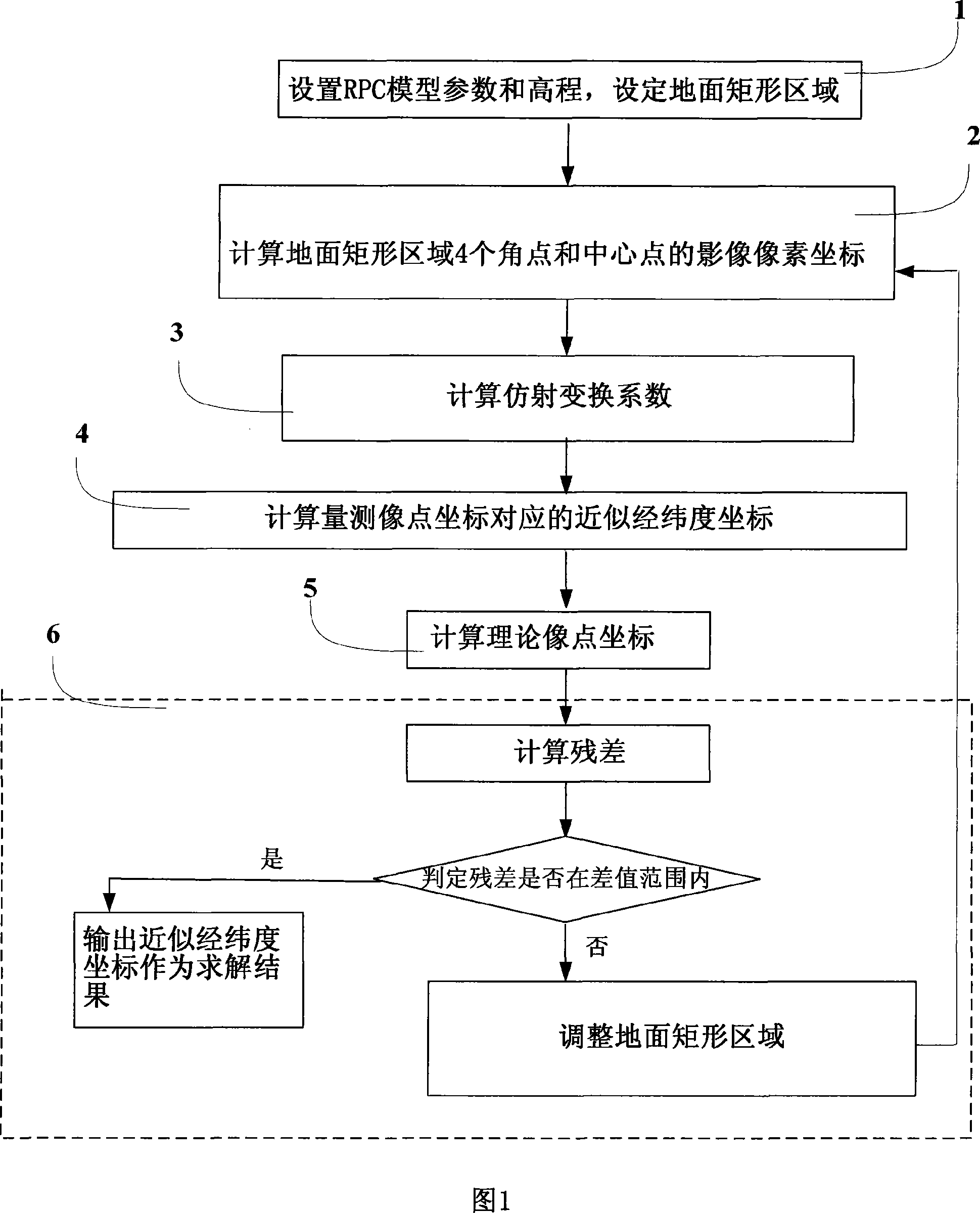
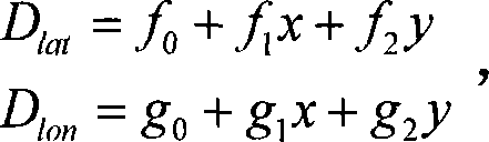
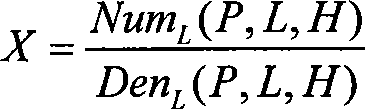
RPC model forward transform method
PatentInactiveCN101101674A
Innovation
- The inverse transformation result of the RPC model is introduced into the forward transformation process for iterative transformation. By setting the longitude and latitude coordinates of the ground rectangular area and the image point coordinates, the affine transformation relationship is used to calculate the approximate affine transformation parameters, and the ground rectangular area is adjusted through the least squares principle. until the set difference range is met.

Using satellite imagery to enhance a 3D surface model of a real world cityscape
PatentActiveUS11210806B1
Innovation
- The method enhances 3D surface models by integrating image data from satellite images, using metadata to geolocate satellite images and aligning them with 3D models, allowing for the addition of detailed imagery to visible surfaces, and adjusting projection models for more accurate geolocation and rendering.


Space Data Governance and Privacy Regulations
The integration of world models into satellite image processing systems introduces complex data governance challenges that require comprehensive regulatory frameworks. Current space data governance operates under a patchwork of national and international regulations, including the Outer Space Treaty of 1967, national space acts, and emerging data protection laws. However, these frameworks were not designed to address the sophisticated data processing capabilities enabled by world models, creating significant regulatory gaps.
Privacy regulations present particular challenges when world models process satellite imagery containing personally identifiable information or sensitive infrastructure details. The European Union's General Data Protection Regulation (GDPR) and similar privacy laws in other jurisdictions establish strict requirements for data processing, storage, and cross-border transfers. When world models enhance satellite image resolution or predict temporal changes, they may inadvertently reveal private information about individuals or commercial activities, triggering privacy compliance obligations.
Cross-border data flows represent another critical governance challenge. Satellite imagery enhanced through world models often involves data processing across multiple jurisdictions, each with distinct regulatory requirements. The United States' International Traffic in Arms Regulations (ITAR) and Export Administration Regulations (EAR) impose restrictions on sharing certain satellite imagery and processing technologies. Similarly, other nations maintain sovereign control over imagery of their territories, complicating the deployment of world model-enhanced processing systems.
Data sovereignty concerns are amplified when world models require extensive training datasets that may include imagery from multiple countries. Nations increasingly assert control over satellite data collected within their borders, requiring local data storage or processing. This trend toward data localization conflicts with the distributed computing architectures typically used for world model training and inference, necessitating new technical and legal frameworks.
Emerging regulatory initiatives specifically address AI-enhanced satellite data processing. The European Union's proposed AI Act includes provisions for high-risk AI applications, potentially encompassing world model-enhanced satellite systems used for critical infrastructure monitoring or security applications. These regulations mandate transparency, accountability, and human oversight requirements that must be integrated into world model architectures.
International coordination mechanisms are evolving to address these governance challenges. The Committee on the Peaceful Uses of Outer Space (COPUOS) and other multilateral forums are developing guidelines for responsible satellite data use. However, the rapid advancement of world model technologies often outpaces regulatory development, creating uncertainty for organizations implementing these systems.
Environmental Impact of Enhanced Satellite Processing
Enhanced satellite image processing using world models presents significant environmental implications that extend beyond technological advancement to encompass broader ecological and sustainability considerations. The implementation of sophisticated world model architectures for satellite imagery analysis fundamentally alters the computational resource requirements and energy consumption patterns associated with Earth observation systems.
The computational intensity of world model-based satellite processing demands substantial increases in processing power, typically requiring high-performance computing clusters and specialized hardware accelerators. This escalation in computational requirements directly translates to increased energy consumption, with modern deep learning inference systems consuming orders of magnitude more power than traditional image processing algorithms. Data centers supporting these enhanced processing capabilities contribute to carbon emissions through their electricity consumption, particularly when powered by non-renewable energy sources.
However, the environmental impact assessment reveals a complex trade-off scenario. Enhanced satellite processing capabilities enable more accurate and timely environmental monitoring, facilitating improved climate change research, deforestation tracking, and natural disaster response. The precision gains achieved through world model integration allow for more efficient resource allocation in environmental protection efforts, potentially offsetting the increased computational carbon footprint through better-informed conservation strategies.
The lifecycle environmental considerations encompass hardware manufacturing impacts, including rare earth element extraction for specialized processing units and the eventual electronic waste generation from obsolete equipment. Advanced satellite processing systems typically require more frequent hardware upgrades to maintain performance standards, accelerating the replacement cycle and associated environmental costs.
Emerging trends toward edge computing and on-satellite processing present opportunities to mitigate some environmental impacts by reducing data transmission requirements and enabling distributed processing architectures. Additionally, the integration of renewable energy sources in data center operations and the development of more energy-efficient neural network architectures offer pathways to minimize the environmental footprint while maintaining enhanced processing capabilities.
The net environmental impact ultimately depends on the balance between increased computational demands and the environmental benefits derived from improved Earth observation capabilities, requiring careful consideration of implementation strategies and energy sourcing decisions.
Unlock deeper insights with Patsnap Eureka Quick Research — get a full tech report to explore trends and direct your research. Try now!
Generate Your Research Report Instantly with AI Agent
Supercharge your innovation with Patsnap Eureka AI Agent Platform!