

How to Optimize Synthetic Aperture Radar for Precision Mapping
MAR 26, 20269 MIN READ
Generate Your Research Report Instantly with AI Agent
PatSnap Eureka helps you evaluate technical feasibility & market potential.
SAR Precision Mapping Technology Background and Objectives
Synthetic Aperture Radar (SAR) technology has evolved significantly since its inception in the 1950s, transforming from a military reconnaissance tool to a versatile civilian remote sensing platform. The fundamental principle of SAR involves using the motion of a radar antenna over a target region to create high-resolution imagery through signal processing techniques that synthesize a larger antenna aperture. This capability enables all-weather, day-and-night imaging with penetration through clouds and vegetation, making it invaluable for precision mapping applications.
The evolution of SAR systems has been marked by continuous improvements in spatial resolution, radiometric accuracy, and operational flexibility. Early SAR systems achieved resolutions of several meters, while modern systems can deliver sub-meter resolution imagery. The transition from analog to digital processing, coupled with advances in semiconductor technology and signal processing algorithms, has dramatically enhanced the precision and reliability of SAR-based mapping solutions.
Current precision mapping demands require SAR systems to achieve centimeter-level accuracy for applications such as infrastructure monitoring, geological surveys, and urban planning. The integration of interferometric SAR (InSAR) and differential InSAR (DInSAR) techniques has enabled precise measurement of surface deformation and topographic changes over time. These capabilities are essential for monitoring subsidence, landslides, and structural health of critical infrastructure.
The primary technical objectives for optimizing SAR precision mapping include enhancing spatial resolution through improved signal processing algorithms, reducing phase noise and systematic errors, and developing robust calibration methodologies. Advanced beamforming techniques, such as digital beamforming and multiple-input multiple-output (MIMO) configurations, offer pathways to achieve finer resolution while maintaining wide swath coverage.
Radiometric calibration accuracy represents another critical objective, requiring precise characterization of system parameters and environmental effects. The development of active radar calibrators and corner reflector networks has improved absolute radiometric accuracy to better than 0.5 dB, enabling quantitative analysis of surface properties and change detection with high confidence levels.
Future optimization efforts focus on implementing artificial intelligence and machine learning algorithms for automated image processing, phase unwrapping, and error correction. These technologies promise to reduce processing time while improving the consistency and accuracy of mapping products, ultimately advancing SAR's role in precision geospatial applications.
The evolution of SAR systems has been marked by continuous improvements in spatial resolution, radiometric accuracy, and operational flexibility. Early SAR systems achieved resolutions of several meters, while modern systems can deliver sub-meter resolution imagery. The transition from analog to digital processing, coupled with advances in semiconductor technology and signal processing algorithms, has dramatically enhanced the precision and reliability of SAR-based mapping solutions.
Current precision mapping demands require SAR systems to achieve centimeter-level accuracy for applications such as infrastructure monitoring, geological surveys, and urban planning. The integration of interferometric SAR (InSAR) and differential InSAR (DInSAR) techniques has enabled precise measurement of surface deformation and topographic changes over time. These capabilities are essential for monitoring subsidence, landslides, and structural health of critical infrastructure.
The primary technical objectives for optimizing SAR precision mapping include enhancing spatial resolution through improved signal processing algorithms, reducing phase noise and systematic errors, and developing robust calibration methodologies. Advanced beamforming techniques, such as digital beamforming and multiple-input multiple-output (MIMO) configurations, offer pathways to achieve finer resolution while maintaining wide swath coverage.
Radiometric calibration accuracy represents another critical objective, requiring precise characterization of system parameters and environmental effects. The development of active radar calibrators and corner reflector networks has improved absolute radiometric accuracy to better than 0.5 dB, enabling quantitative analysis of surface properties and change detection with high confidence levels.
Future optimization efforts focus on implementing artificial intelligence and machine learning algorithms for automated image processing, phase unwrapping, and error correction. These technologies promise to reduce processing time while improving the consistency and accuracy of mapping products, ultimately advancing SAR's role in precision geospatial applications.
Market Demand Analysis for High-Resolution SAR Mapping
The global demand for high-resolution SAR mapping services has experienced unprecedented growth across multiple sectors, driven by the increasing need for precise geospatial intelligence and real-time monitoring capabilities. Government agencies, defense organizations, and commercial enterprises are actively seeking advanced SAR solutions that can deliver centimeter-level accuracy for critical applications ranging from infrastructure monitoring to disaster response.
The defense and security sector represents the largest market segment, with military organizations requiring enhanced surveillance capabilities for border monitoring, threat assessment, and strategic planning. These applications demand SAR systems capable of penetrating adverse weather conditions while maintaining exceptional resolution for target identification and terrain analysis. The growing emphasis on national security and border protection has intensified procurement activities for next-generation SAR technologies.
Commercial applications are rapidly expanding, particularly in the oil and gas industry where precision mapping is essential for pipeline monitoring, exploration activities, and environmental compliance. Mining companies increasingly rely on high-resolution SAR data for site surveying, subsidence monitoring, and resource extraction planning. The agriculture sector has emerged as a significant growth driver, utilizing SAR mapping for crop monitoring, yield prediction, and precision farming applications that require detailed soil moisture and vegetation analysis.
Infrastructure monitoring represents another critical market segment, with transportation authorities, utility companies, and urban planners demanding precise SAR capabilities for bridge inspection, railway monitoring, and smart city development. The ability to detect millimeter-scale deformation in critical infrastructure has become essential for preventive maintenance and public safety assurance.
The environmental monitoring market continues to expand as climate change concerns intensify. Research institutions and environmental agencies require high-resolution SAR systems for glacier monitoring, deforestation tracking, and coastal erosion assessment. These applications demand consistent data quality and temporal resolution to support long-term environmental studies and policy development.
Emerging markets in autonomous vehicle development and smart transportation systems are creating new demand patterns for precision SAR mapping. The integration of SAR data with artificial intelligence and machine learning platforms is opening additional market opportunities in predictive analytics and automated monitoring solutions.
Market growth is further accelerated by the increasing availability of commercial SAR satellites and the democratization of geospatial data access. Small and medium enterprises are now able to leverage high-resolution SAR services for specialized applications, expanding the overall market base beyond traditional large-scale users.
The defense and security sector represents the largest market segment, with military organizations requiring enhanced surveillance capabilities for border monitoring, threat assessment, and strategic planning. These applications demand SAR systems capable of penetrating adverse weather conditions while maintaining exceptional resolution for target identification and terrain analysis. The growing emphasis on national security and border protection has intensified procurement activities for next-generation SAR technologies.
Commercial applications are rapidly expanding, particularly in the oil and gas industry where precision mapping is essential for pipeline monitoring, exploration activities, and environmental compliance. Mining companies increasingly rely on high-resolution SAR data for site surveying, subsidence monitoring, and resource extraction planning. The agriculture sector has emerged as a significant growth driver, utilizing SAR mapping for crop monitoring, yield prediction, and precision farming applications that require detailed soil moisture and vegetation analysis.
Infrastructure monitoring represents another critical market segment, with transportation authorities, utility companies, and urban planners demanding precise SAR capabilities for bridge inspection, railway monitoring, and smart city development. The ability to detect millimeter-scale deformation in critical infrastructure has become essential for preventive maintenance and public safety assurance.
The environmental monitoring market continues to expand as climate change concerns intensify. Research institutions and environmental agencies require high-resolution SAR systems for glacier monitoring, deforestation tracking, and coastal erosion assessment. These applications demand consistent data quality and temporal resolution to support long-term environmental studies and policy development.
Emerging markets in autonomous vehicle development and smart transportation systems are creating new demand patterns for precision SAR mapping. The integration of SAR data with artificial intelligence and machine learning platforms is opening additional market opportunities in predictive analytics and automated monitoring solutions.
Market growth is further accelerated by the increasing availability of commercial SAR satellites and the democratization of geospatial data access. Small and medium enterprises are now able to leverage high-resolution SAR services for specialized applications, expanding the overall market base beyond traditional large-scale users.
Current SAR Technology Status and Optimization Challenges
Synthetic Aperture Radar technology has reached significant maturity in recent decades, with operational systems demonstrating remarkable capabilities in Earth observation, defense applications, and commercial mapping services. Current SAR systems operate across multiple frequency bands, including X-band, C-band, and L-band, each offering distinct advantages for specific mapping applications. Modern spaceborne SAR platforms such as Sentinel-1, TerraSAR-X, and COSMO-SkyMed have established baseline performance standards for precision mapping, achieving spatial resolutions ranging from sub-meter to several meters depending on operational modes.
The fundamental challenge in SAR optimization for precision mapping lies in the inherent trade-offs between spatial resolution, temporal coverage, and signal-to-noise ratio. Higher resolution imaging requires increased bandwidth and processing complexity, while maintaining adequate coverage necessitates compromises in revisit times. Current systems struggle to simultaneously optimize all performance parameters, leading to mission-specific configurations that excel in particular aspects while sacrificing others.
Signal processing limitations represent another critical bottleneck in achieving optimal precision mapping performance. Traditional range-Doppler algorithms, while computationally efficient, introduce geometric distortions and artifacts that degrade mapping accuracy. Advanced processing techniques such as back-projection algorithms offer improved image quality but demand substantially higher computational resources, creating practical implementation challenges for real-time applications.
Atmospheric interference and propagation effects continue to pose significant challenges for precision mapping applications. Ionospheric delays, particularly affecting lower frequency bands, introduce phase errors that directly impact interferometric measurements and change detection capabilities. Tropospheric variations cause additional distortions that are difficult to model and compensate accurately, especially in regions with complex meteorological conditions.
Hardware constraints in current SAR systems limit optimization potential across multiple dimensions. Antenna size restrictions on spaceborne platforms constrain achievable azimuth resolution, while power limitations affect signal strength and penetration capabilities. Thermal management issues in space-based systems further restrict operational duty cycles, impacting data acquisition strategies and temporal resolution requirements.
Calibration and stability requirements for precision mapping applications exceed current system capabilities in many scenarios. Radiometric accuracy, phase stability, and geometric precision must be maintained across extended operational periods, requiring sophisticated calibration schemes and reference target networks. Current approaches often rely on external calibration sources that may not be available in all geographic regions or operational conditions.
The integration of multiple SAR platforms and data fusion techniques presents both opportunities and challenges for precision mapping optimization. While multi-temporal and multi-frequency approaches can enhance mapping accuracy, they introduce complex data processing requirements and increase system complexity. Standardization issues across different SAR systems complicate seamless data integration and limit the effectiveness of combined processing approaches.
The fundamental challenge in SAR optimization for precision mapping lies in the inherent trade-offs between spatial resolution, temporal coverage, and signal-to-noise ratio. Higher resolution imaging requires increased bandwidth and processing complexity, while maintaining adequate coverage necessitates compromises in revisit times. Current systems struggle to simultaneously optimize all performance parameters, leading to mission-specific configurations that excel in particular aspects while sacrificing others.
Signal processing limitations represent another critical bottleneck in achieving optimal precision mapping performance. Traditional range-Doppler algorithms, while computationally efficient, introduce geometric distortions and artifacts that degrade mapping accuracy. Advanced processing techniques such as back-projection algorithms offer improved image quality but demand substantially higher computational resources, creating practical implementation challenges for real-time applications.
Atmospheric interference and propagation effects continue to pose significant challenges for precision mapping applications. Ionospheric delays, particularly affecting lower frequency bands, introduce phase errors that directly impact interferometric measurements and change detection capabilities. Tropospheric variations cause additional distortions that are difficult to model and compensate accurately, especially in regions with complex meteorological conditions.
Hardware constraints in current SAR systems limit optimization potential across multiple dimensions. Antenna size restrictions on spaceborne platforms constrain achievable azimuth resolution, while power limitations affect signal strength and penetration capabilities. Thermal management issues in space-based systems further restrict operational duty cycles, impacting data acquisition strategies and temporal resolution requirements.
Calibration and stability requirements for precision mapping applications exceed current system capabilities in many scenarios. Radiometric accuracy, phase stability, and geometric precision must be maintained across extended operational periods, requiring sophisticated calibration schemes and reference target networks. Current approaches often rely on external calibration sources that may not be available in all geographic regions or operational conditions.
The integration of multiple SAR platforms and data fusion techniques presents both opportunities and challenges for precision mapping optimization. While multi-temporal and multi-frequency approaches can enhance mapping accuracy, they introduce complex data processing requirements and increase system complexity. Standardization issues across different SAR systems complicate seamless data integration and limit the effectiveness of combined processing approaches.
Current SAR Optimization Solutions and Techniques
01 Signal processing and motion compensation techniques
Advanced signal processing methods are employed to enhance SAR precision by compensating for platform motion errors and atmospheric disturbances. These techniques include motion compensation algorithms that correct for deviations in the radar platform's trajectory, phase error correction methods, and adaptive filtering approaches. By accurately accounting for motion-induced phase errors and implementing sophisticated processing algorithms, the geometric accuracy and image quality of SAR systems can be significantly improved.- Advanced signal processing techniques for improved resolution: Synthetic aperture radar precision can be enhanced through sophisticated signal processing algorithms that improve image resolution and target detection. These techniques include advanced filtering methods, phase correction algorithms, and multi-look processing to reduce speckle noise and enhance image quality. Digital signal processing approaches enable better extraction of target information from radar returns, leading to more accurate measurements and improved overall system performance.
- Motion compensation and platform stabilization methods: Precision in synthetic aperture radar systems can be significantly improved through motion compensation techniques that account for platform instabilities and deviations from ideal flight paths. These methods utilize inertial measurement units, GPS data, and autofocus algorithms to correct for motion errors during data acquisition. Advanced stabilization approaches help maintain coherent signal integration over the synthetic aperture, resulting in sharper images and more accurate geolocation of targets.
- Interferometric SAR techniques for high-precision measurements: Interferometric synthetic aperture radar methods enable precise elevation measurements and deformation detection by analyzing phase differences between multiple radar acquisitions. These techniques achieve millimeter-level precision in measuring surface changes and topography through careful phase unwrapping and baseline estimation. Applications include terrain mapping, subsidence monitoring, and structural deformation analysis with unprecedented accuracy.
- Calibration and error correction mechanisms: System calibration procedures and error correction techniques are essential for maintaining synthetic aperture radar precision. These include internal calibration using reference targets, atmospheric correction methods, and compensation for system distortions. Regular calibration ensures consistent performance across different operating conditions and enables accurate radiometric and geometric measurements. Error sources such as timing jitter, phase noise, and antenna pattern variations are systematically identified and corrected.
- Multi-frequency and polarimetric SAR configurations: Enhanced precision can be achieved through multi-frequency and polarimetric synthetic aperture radar architectures that provide complementary information about targets. Different frequency bands offer varying penetration capabilities and resolution characteristics, while polarimetric measurements enable detailed characterization of target scattering properties. These advanced configurations improve classification accuracy, target discrimination, and overall measurement precision through fusion of multiple data channels.
02 Calibration and error correction methods
Precision calibration techniques are essential for improving SAR accuracy by identifying and correcting systematic errors in the radar system. These methods involve the use of ground control points, corner reflectors, and active transponders to measure and compensate for geometric distortions, timing errors, and amplitude variations. Internal calibration loops and external reference targets enable continuous monitoring and adjustment of system parameters to maintain high precision throughout the operational lifetime of the SAR system.Expand Specific Solutions03 Interferometric SAR techniques for precision measurement
Interferometric synthetic aperture radar techniques utilize phase differences between multiple SAR acquisitions to achieve high-precision measurements of surface topography and displacement. By processing data from repeat-pass or single-pass interferometric configurations, these methods can detect millimeter-level changes in terrain elevation and ground deformation. Advanced interferometric processing algorithms, including phase unwrapping and coherence optimization, enable precise geodetic measurements for applications such as subsidence monitoring and digital elevation model generation.Expand Specific Solutions04 Antenna design and beamforming optimization
Precision in SAR systems is enhanced through optimized antenna designs and advanced beamforming techniques that improve spatial resolution and reduce sidelobe levels. Phased array antennas with precise element positioning and calibration enable accurate beam steering and pattern control. Digital beamforming methods allow for adaptive pattern synthesis and null steering to suppress interference. These antenna technologies contribute to improved azimuth and range resolution, resulting in higher geometric accuracy and image quality.Expand Specific Solutions05 Autofocus and image formation algorithms
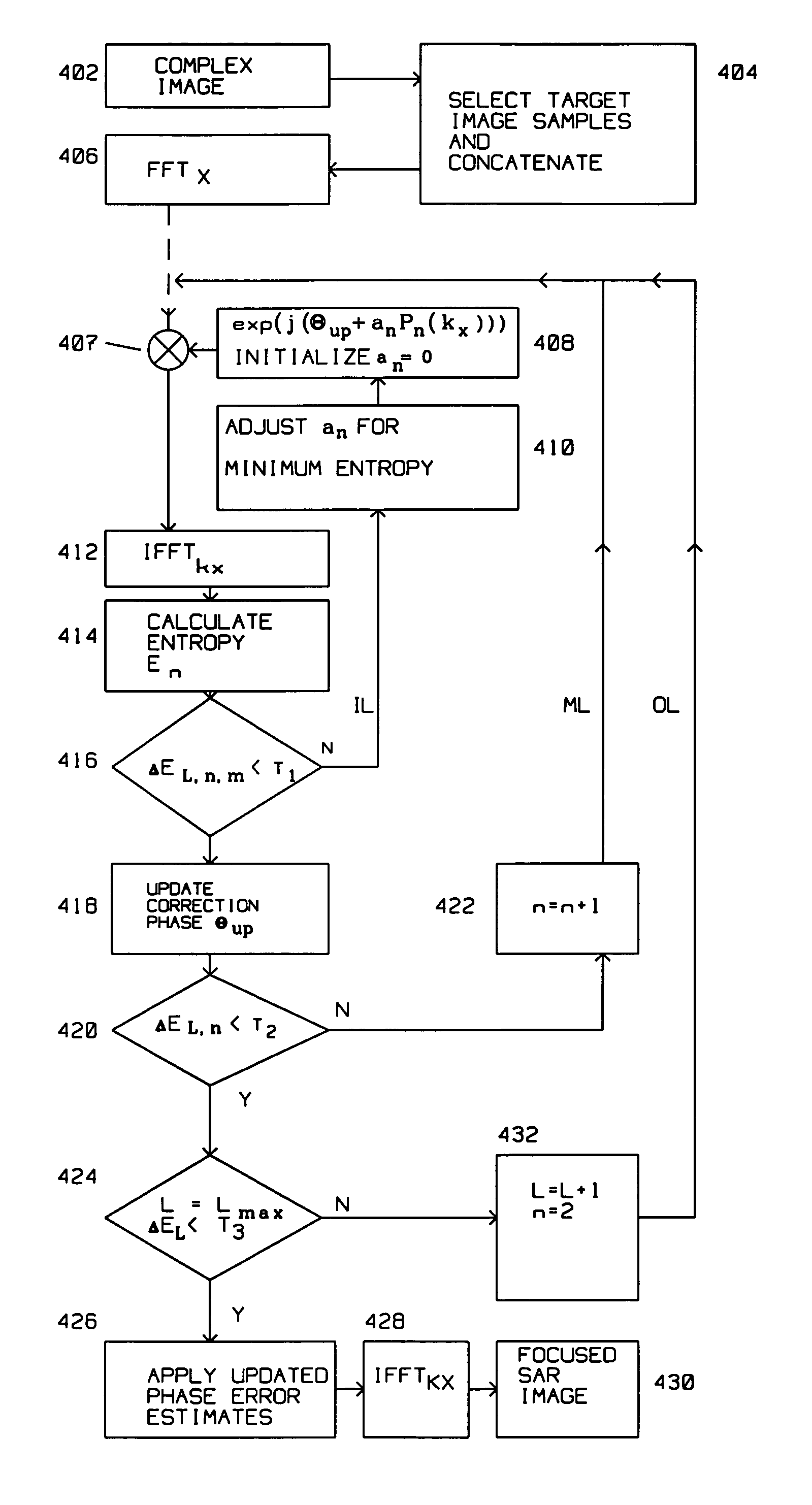
Autofocus techniques automatically correct residual phase errors in SAR imagery to achieve optimal focus and precision without requiring external reference data. These algorithms estimate and compensate for unmodeled motion errors, atmospheric effects, and system instabilities through iterative optimization of image sharpness metrics. Advanced image formation methods, including backprojection algorithms and polar format processing, provide precise geometric mapping and reduce distortions. The combination of robust autofocus and sophisticated image formation enhances the overall precision and interpretability of SAR products.Expand Specific Solutions
Major SAR System Manufacturers and Technology Leaders
The synthetic aperture radar (SAR) optimization market for precision mapping represents a mature technology sector experiencing significant growth driven by increasing demand for high-resolution earth observation capabilities. The industry has evolved from early military applications to diverse commercial uses including agriculture, infrastructure monitoring, and disaster management. Major defense contractors like Raytheon, Boeing, Thales, and Mitsubishi Electric dominate the established market with proven SAR systems, while aerospace leaders such as Airbus Defence & Space and government agencies like DLR and ESA drive technological advancement. Emerging players like Spacealpha Insights are introducing innovative AI-enhanced SAR-XL technology, indicating the sector's transition toward next-generation capabilities. Chinese institutions including Xidian University and Beijing Institute of Technology contribute substantial research, reflecting global competition in this strategically important field.
Raytheon Co.
Technical Solution: Raytheon develops advanced SAR systems utilizing multi-mode radar architectures with adaptive beamforming technology. Their approach incorporates digital signal processing algorithms that enable real-time image formation with sub-meter resolution capabilities. The company's SAR optimization focuses on frequency diversity techniques and polarimetric processing to enhance target discrimination and reduce speckle noise. Their systems feature advanced motion compensation algorithms and autofocus techniques that maintain image quality across various platform dynamics. Raytheon's precision mapping solutions integrate machine learning algorithms for automated feature extraction and terrain classification, significantly improving mapping accuracy for defense and commercial applications.
Strengths: Proven defense contractor with extensive SAR experience and robust signal processing capabilities. Weaknesses: High cost systems primarily focused on military applications with limited commercial accessibility.
The Boeing Co.
Technical Solution: Boeing develops SAR optimization solutions through their ScanEagle and other unmanned platforms, focusing on lightweight, high-performance radar systems for precision mapping applications. Their approach emphasizes miniaturized SAR architectures with advanced digital beamforming and real-time processing capabilities. Boeing's systems utilize adaptive waveform selection and multi-frequency operation to optimize penetration characteristics for different terrain types. The company implements sophisticated motion compensation algorithms specifically designed for small UAV platforms, addressing stability challenges inherent in lightweight aircraft. Their precision mapping solutions incorporate automated target recognition algorithms and change detection capabilities, enabling rapid assessment of infrastructure and environmental monitoring with enhanced accuracy through multi-temporal analysis techniques.
Strengths: Extensive aerospace experience with innovative UAV-based SAR platforms and flexible deployment capabilities. Weaknesses: Smaller SAR market presence compared to specialized radar companies and limited ground-based processing infrastructure.
Core SAR Signal Processing and Algorithm Innovations
Correction of spatially variant phase error for synthetic aperture radar
PatentActiveUS20100086228A1
Innovation
- A method that identifies a spatial model for phase error variation, divides the image into subpatches based on this model, applies phase correction to each subpatch, and merges the focused subpatches to form a uniformly focused image, effectively addressing spatially variant phase errors without relying on terrain elevation data.


Autofocus method based on successive parameter adjustments for contrast optimization
PatentInactiveUS7145496B2
Innovation
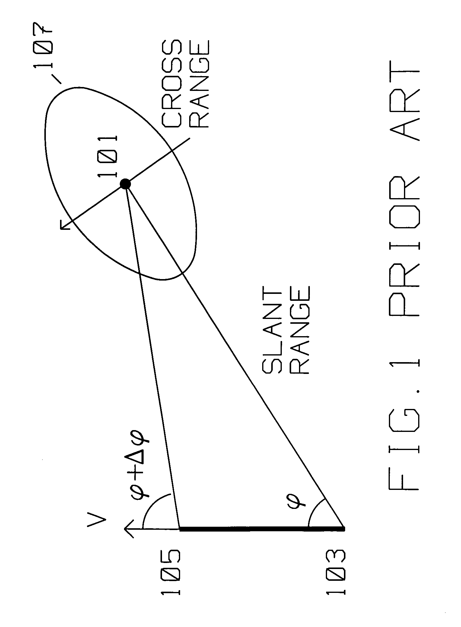
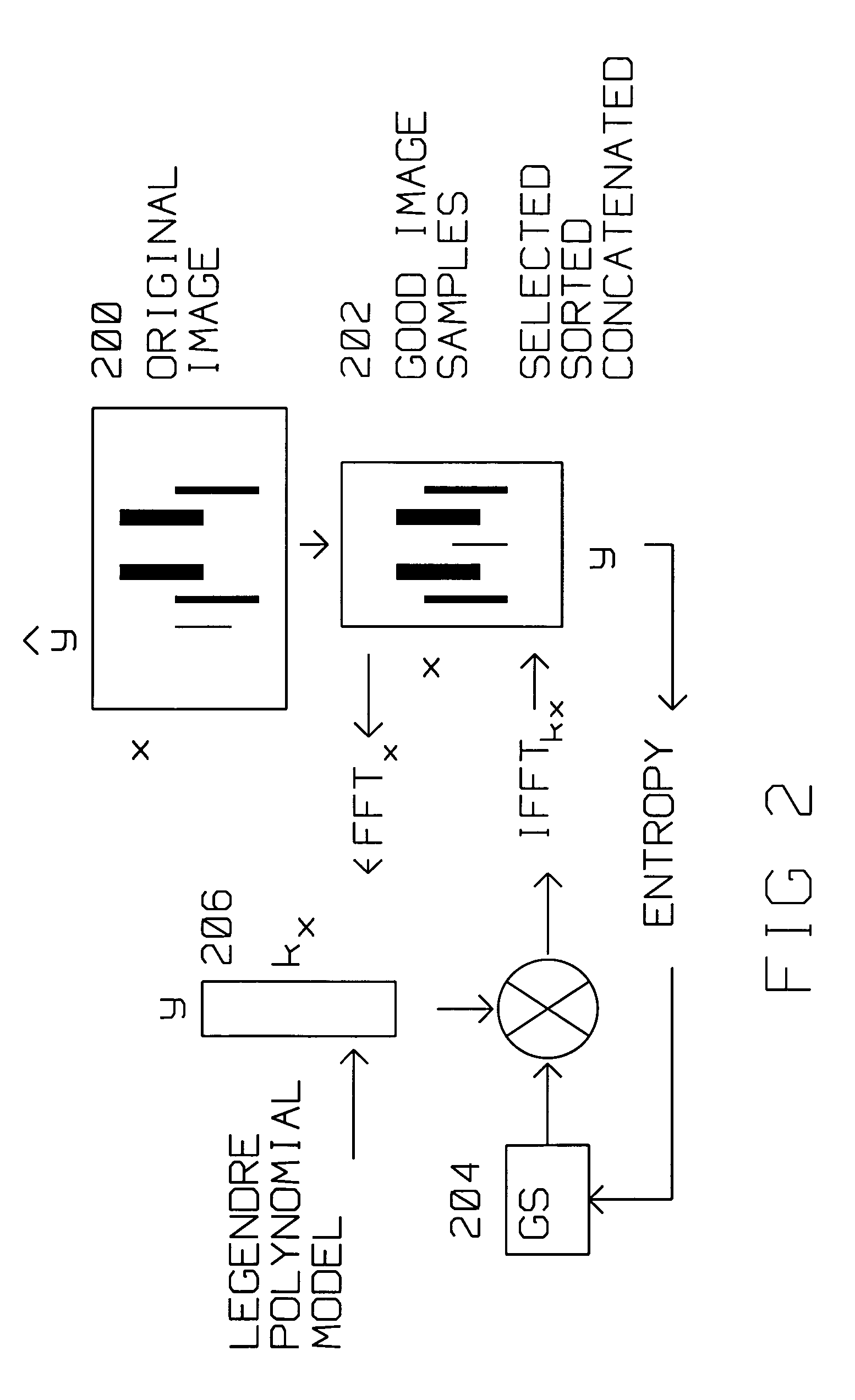
- The Successive Parameter Adjustment (SPA) method uses an orthogonal polynomial to iteratively compute phase corrections, employing a Golden Section search and entropy minimization to improve image contrast and sharpness, applicable to SAR scenes without point-like targets and tolerant of missing pulses, allowing for flexible data processing.

Spectrum Allocation and Regulatory Framework for SAR
The spectrum allocation framework for Synthetic Aperture Radar systems represents a critical foundation for precision mapping applications, governed by international and national regulatory bodies that coordinate frequency assignments across multiple bands. The International Telecommunication Union allocates specific frequency ranges for radar applications, with SAR systems primarily operating in L-band (1-2 GHz), S-band (2-4 GHz), C-band (4-8 GHz), X-band (8-12 GHz), and Ku-band (12-18 GHz) segments. Each frequency band offers distinct advantages for precision mapping, with lower frequencies providing better penetration capabilities and higher frequencies delivering enhanced resolution characteristics.
National regulatory authorities implement ITU guidelines through domestic spectrum management policies, creating a complex landscape of frequency coordination requirements. The Federal Communications Commission in the United States, European Communications Committee in Europe, and similar bodies worldwide establish specific operational parameters including power limitations, bandwidth restrictions, and interference mitigation protocols. These regulations directly impact SAR system design choices, particularly regarding pulse repetition frequency, chirp bandwidth, and antenna beamwidth specifications that determine mapping precision capabilities.
Cross-border coordination mechanisms become increasingly important as SAR platforms operate across international boundaries, requiring harmonized spectrum usage protocols to prevent interference with terrestrial communication systems and other radar applications. The Radio Regulations framework establishes coordination procedures for satellite-based SAR systems, mandating interference analysis and mitigation strategies when operating near populated areas or sensitive communication infrastructure.
Emerging regulatory challenges include spectrum sharing with 5G networks, particularly in C-band frequencies where commercial wireless services are expanding rapidly. This evolution necessitates dynamic spectrum access techniques and cognitive radio approaches that enable SAR systems to adapt their operational parameters in real-time while maintaining precision mapping performance standards.
Future regulatory developments focus on establishing flexible allocation frameworks that accommodate next-generation SAR technologies, including distributed antenna systems and formation-flying satellite constellations. These advanced architectures require updated coordination procedures and interference assessment methodologies to ensure optimal spectrum utilization while preserving the precision mapping capabilities essential for scientific and commercial applications.
National regulatory authorities implement ITU guidelines through domestic spectrum management policies, creating a complex landscape of frequency coordination requirements. The Federal Communications Commission in the United States, European Communications Committee in Europe, and similar bodies worldwide establish specific operational parameters including power limitations, bandwidth restrictions, and interference mitigation protocols. These regulations directly impact SAR system design choices, particularly regarding pulse repetition frequency, chirp bandwidth, and antenna beamwidth specifications that determine mapping precision capabilities.
Cross-border coordination mechanisms become increasingly important as SAR platforms operate across international boundaries, requiring harmonized spectrum usage protocols to prevent interference with terrestrial communication systems and other radar applications. The Radio Regulations framework establishes coordination procedures for satellite-based SAR systems, mandating interference analysis and mitigation strategies when operating near populated areas or sensitive communication infrastructure.
Emerging regulatory challenges include spectrum sharing with 5G networks, particularly in C-band frequencies where commercial wireless services are expanding rapidly. This evolution necessitates dynamic spectrum access techniques and cognitive radio approaches that enable SAR systems to adapt their operational parameters in real-time while maintaining precision mapping performance standards.
Future regulatory developments focus on establishing flexible allocation frameworks that accommodate next-generation SAR technologies, including distributed antenna systems and formation-flying satellite constellations. These advanced architectures require updated coordination procedures and interference assessment methodologies to ensure optimal spectrum utilization while preserving the precision mapping capabilities essential for scientific and commercial applications.
Environmental Impact Assessment of SAR Operations
The environmental implications of Synthetic Aperture Radar operations for precision mapping applications present a complex landscape of considerations that must be carefully evaluated. Unlike traditional optical remote sensing systems, SAR technology operates through active microwave transmission, creating unique environmental interaction patterns that require comprehensive assessment.
SAR systems generate electromagnetic radiation in the microwave spectrum, typically operating between 1-40 GHz frequencies. While these emissions are significantly lower in power compared to commercial broadcasting systems, their potential cumulative effects on sensitive ecosystems warrant systematic evaluation. The electromagnetic field exposure levels must be assessed against established safety thresholds for both terrestrial and marine environments.
Wildlife impact assessment represents a critical component of SAR environmental evaluation. Migratory bird populations, particularly those following established flight corridors, may experience disruption from radar emissions during critical navigation periods. Marine mammals utilizing echolocation systems could potentially face interference from overlapping frequency ranges, though current research suggests minimal impact at typical SAR operational altitudes.
Ground-based infrastructure supporting SAR operations introduces additional environmental considerations. Processing facilities require substantial energy consumption for data handling and storage, contributing to carbon footprint calculations. The deployment of ground control stations and calibration targets may necessitate habitat modification in sensitive areas, requiring careful site selection and mitigation strategies.
Atmospheric interaction effects present both challenges and opportunities for environmental stewardship. SAR operations can contribute valuable data for climate monitoring and environmental change detection, potentially offsetting operational impacts through enhanced scientific understanding. However, signal propagation through various atmospheric conditions may require power adjustments that influence overall environmental exposure levels.
Long-term monitoring protocols must establish baseline measurements for electromagnetic field levels in operational areas. Regular assessment of flora and fauna populations near SAR facilities enables early detection of potential adverse effects. Collaboration with environmental agencies ensures compliance with evolving regulations and incorporation of emerging scientific findings into operational procedures.
Mitigation strategies should encompass both technological and operational approaches. Advanced beamforming techniques can minimize off-target radiation exposure while maintaining mapping precision. Temporal restrictions during sensitive periods, such as breeding seasons or migration windows, provide additional protection for vulnerable species while preserving mission capabilities.
SAR systems generate electromagnetic radiation in the microwave spectrum, typically operating between 1-40 GHz frequencies. While these emissions are significantly lower in power compared to commercial broadcasting systems, their potential cumulative effects on sensitive ecosystems warrant systematic evaluation. The electromagnetic field exposure levels must be assessed against established safety thresholds for both terrestrial and marine environments.
Wildlife impact assessment represents a critical component of SAR environmental evaluation. Migratory bird populations, particularly those following established flight corridors, may experience disruption from radar emissions during critical navigation periods. Marine mammals utilizing echolocation systems could potentially face interference from overlapping frequency ranges, though current research suggests minimal impact at typical SAR operational altitudes.
Ground-based infrastructure supporting SAR operations introduces additional environmental considerations. Processing facilities require substantial energy consumption for data handling and storage, contributing to carbon footprint calculations. The deployment of ground control stations and calibration targets may necessitate habitat modification in sensitive areas, requiring careful site selection and mitigation strategies.
Atmospheric interaction effects present both challenges and opportunities for environmental stewardship. SAR operations can contribute valuable data for climate monitoring and environmental change detection, potentially offsetting operational impacts through enhanced scientific understanding. However, signal propagation through various atmospheric conditions may require power adjustments that influence overall environmental exposure levels.
Long-term monitoring protocols must establish baseline measurements for electromagnetic field levels in operational areas. Regular assessment of flora and fauna populations near SAR facilities enables early detection of potential adverse effects. Collaboration with environmental agencies ensures compliance with evolving regulations and incorporation of emerging scientific findings into operational procedures.
Mitigation strategies should encompass both technological and operational approaches. Advanced beamforming techniques can minimize off-target radiation exposure while maintaining mapping precision. Temporal restrictions during sensitive periods, such as breeding seasons or migration windows, provide additional protection for vulnerable species while preserving mission capabilities.
Unlock deeper insights with PatSnap Eureka Quick Research — get a full tech report to explore trends and direct your research. Try now!
Generate Your Research Report Instantly with AI Agent
Supercharge your innovation with PatSnap Eureka AI Agent Platform!