

Synthetic Aperture Radar Vs Magnetometer: Resource Mapping Performance
MAR 26, 20269 MIN READ
Generate Your Research Report Instantly with AI Agent
PatSnap Eureka helps you evaluate technical feasibility & market potential.
SAR vs Magnetometer Resource Mapping Background and Objectives
Resource mapping has evolved significantly over the past several decades, driven by increasing demand for mineral exploration, environmental monitoring, and geological surveying. Traditional ground-based methods, while accurate, proved time-consuming and costly for large-scale operations. The advent of remote sensing technologies revolutionized this field, introducing airborne and satellite-based solutions that could cover vast areas efficiently.
Synthetic Aperture Radar emerged as a powerful remote sensing tool in the 1970s, initially developed for military reconnaissance applications. Its ability to penetrate cloud cover and operate in all weather conditions made it particularly valuable for consistent data acquisition. SAR technology generates high-resolution images by synthesizing a large antenna aperture through the motion of a smaller antenna, enabling detailed surface mapping and subsurface feature detection through various polarization modes and frequency bands.
Magnetometer technology, with roots dating back to the early 20th century, has been extensively used in geophysical surveys for mineral exploration. Airborne magnetometry became commercially viable in the 1940s, allowing rapid measurement of magnetic field variations across large areas. Modern magnetometers can detect minute variations in Earth's magnetic field caused by subsurface geological structures and mineral deposits, making them indispensable for resource exploration.
The primary objective of comparing SAR and magnetometer technologies lies in understanding their respective strengths and limitations for resource mapping applications. SAR excels in surface feature identification, structural geology mapping, and terrain analysis, while magnetometers provide direct measurement of magnetic anomalies associated with specific mineral deposits. Each technology offers unique advantages depending on the target resources, geological conditions, and operational requirements.
Current research focuses on optimizing detection capabilities for different resource types, including metallic ores, hydrocarbon deposits, and groundwater resources. The integration of multiple sensor technologies represents a growing trend, as combined datasets often provide more comprehensive geological insights than individual systems alone.
The ultimate goal involves developing cost-effective, accurate, and reliable remote sensing solutions that can identify promising exploration targets while minimizing environmental impact and operational costs. Understanding the performance characteristics of both SAR and magnetometer systems enables informed decision-making for resource exploration projects across diverse geological environments and target commodities.
Market Demand for Advanced Geological Resource Mapping
The global geological resource mapping market is experiencing unprecedented growth driven by increasing demand for critical minerals, energy resources, and infrastructure development. Mining companies worldwide are seeking more efficient and cost-effective exploration methods to identify mineral deposits, particularly rare earth elements essential for renewable energy technologies and electronic devices. The transition toward sustainable energy systems has intensified the need for lithium, cobalt, and other battery materials, creating substantial market pressure for advanced geological surveying capabilities.
Traditional geological exploration methods are proving inadequate for meeting current exploration timelines and accuracy requirements. The industry faces mounting pressure to reduce exploration costs while improving discovery rates, as easily accessible surface deposits become increasingly scarce. This challenge has created a significant market opportunity for advanced remote sensing technologies that can penetrate subsurface layers and provide detailed geological information without extensive ground-based operations.
Government initiatives supporting domestic mineral security have further amplified market demand. National geological surveys and defense agencies require comprehensive mapping capabilities to assess strategic mineral reserves and reduce dependence on foreign suppliers. Environmental regulations also drive demand for precise geological mapping to minimize exploration impact and ensure sustainable resource extraction practices.
The oil and gas sector represents another substantial market segment requiring advanced geological mapping solutions. Exploration companies need detailed subsurface imaging capabilities to identify hydrocarbon reservoirs and optimize drilling locations. Offshore exploration activities particularly benefit from remote sensing technologies that can survey vast oceanic areas efficiently.
Infrastructure development projects across emerging economies create additional market opportunities. Large-scale construction projects require detailed geological assessments to ensure foundation stability and identify potential hazards. Urban planning initiatives also depend on comprehensive geological mapping to support sustainable development and disaster risk reduction.
The market shows strong regional variations, with North America and Australia leading in advanced exploration technology adoption. Asia-Pacific regions demonstrate rapid growth potential due to increasing mining activities and government investments in geological surveying capabilities. European markets focus primarily on critical mineral security and sustainable exploration practices.
Technological convergence trends indicate growing market preference for integrated geological mapping solutions that combine multiple sensing modalities. End users increasingly demand comprehensive geological intelligence platforms rather than standalone surveying tools, creating opportunities for advanced comparative analysis between different sensing technologies.
Current SAR and Magnetometer Technology Status and Challenges
Synthetic Aperture Radar technology has achieved significant maturity in recent decades, with current systems capable of generating high-resolution imagery across various frequency bands including X, C, L, and P-band configurations. Modern SAR platforms demonstrate centimeter-level resolution capabilities and can penetrate vegetation canopies to varying degrees depending on wavelength selection. Advanced polarimetric SAR systems now provide multi-dimensional data acquisition, enabling enhanced material discrimination and subsurface feature detection for geological applications.
Contemporary magnetometer technology encompasses both airborne and ground-based systems, with quantum sensors and optically pumped magnetometers representing the current state-of-the-art. These instruments achieve sensitivity levels below 0.01 nanoTesla, enabling detection of subtle magnetic anomalies associated with mineral deposits and geological structures. Gradiometer configurations have further improved spatial resolution and reduced environmental interference, while unmanned aerial vehicle integration has enhanced deployment flexibility and cost-effectiveness.
Despite technological advances, SAR systems face persistent challenges in resource mapping applications. Signal penetration limitations restrict subsurface detection capabilities, particularly in dense vegetation or highly conductive geological environments. Speckle noise continues to affect image quality and interpretation accuracy, while atmospheric conditions can introduce phase distortions that compromise interferometric measurements. Processing computational requirements remain substantial, demanding specialized hardware and expertise for real-time applications.
Magnetometer technology confronts distinct operational challenges that impact resource mapping effectiveness. Magnetic interference from anthropogenic sources increasingly complicates data interpretation in developed regions. Diurnal variations and geomagnetic storms introduce temporal noise that requires sophisticated correction algorithms. Sensor drift and temperature sensitivity demand frequent calibration procedures, while achieving adequate spatial coverage often requires extensive survey campaigns with associated logistical complexities.
Integration challenges emerge when combining SAR and magnetometer datasets for comprehensive resource mapping. Data fusion methodologies must address fundamental differences in spatial resolution, temporal sampling, and physical measurement principles. Standardization of processing workflows remains incomplete across different sensor platforms and manufacturers. Additionally, interpretation expertise requirements span multiple geophysical disciplines, creating workforce development challenges for organizations seeking to implement multi-sensor approaches effectively.
Existing SAR and Magnetometer Resource Mapping Solutions
01 SAR imaging and processing techniques for resource mapping
Synthetic Aperture Radar systems employ advanced signal processing algorithms to generate high-resolution imagery for terrain and resource mapping. These techniques include range-Doppler processing, motion compensation, and image formation algorithms that enhance the detection and characterization of surface features. The processing methods enable accurate mapping of geological structures, mineral deposits, and other natural resources through analysis of backscatter signatures and polarimetric data.- SAR imaging and processing techniques for resource mapping: Synthetic Aperture Radar systems employ advanced signal processing algorithms to generate high-resolution images for terrain and resource mapping. These techniques include focusing algorithms, motion compensation, and image formation methods that enhance the detection and characterization of surface and subsurface features. The processing methods enable accurate mapping of geological structures, mineral deposits, and other natural resources through radar backscatter analysis.
- Integration of magnetometer data with SAR for enhanced resource detection: Combined sensor systems utilize both radar and magnetic field measurements to improve resource mapping accuracy. The integration of magnetometer data with radar imagery provides complementary information about subsurface magnetic anomalies and geological formations. This multi-sensor fusion approach enhances the detection of mineral deposits, particularly ferromagnetic materials, and improves overall mapping performance through data correlation and joint processing techniques.
- Airborne and spaceborne platform configurations for resource surveying: Resource mapping systems are deployed on various aerial and satellite platforms to conduct large-area surveys. These configurations optimize sensor placement, antenna design, and flight parameters to maximize coverage and resolution. Platform stabilization, navigation systems, and data acquisition strategies are specifically designed to support continuous mapping operations over extended geographical areas while maintaining measurement accuracy.
- Signal processing for interference mitigation and data quality enhancement: Advanced filtering and calibration techniques are employed to reduce noise, eliminate interference, and improve the quality of both radar and magnetometer measurements. These methods include adaptive filtering, clutter suppression, and atmospheric correction algorithms that enhance signal-to-noise ratios. The processing chain ensures reliable data extraction even in challenging environmental conditions, improving the accuracy of resource identification and characterization.
- Automated interpretation and classification systems for resource mapping: Machine learning and pattern recognition algorithms are applied to automatically analyze and classify radar and magnetic data for resource identification. These systems employ feature extraction, anomaly detection, and classification techniques to identify potential resource locations and geological structures. Automated interpretation reduces manual analysis time and improves the consistency of mapping results across large datasets, enabling efficient resource exploration and assessment.
02 Integration of magnetometer data with SAR for enhanced resource detection
Combined sensor systems utilize both radar and magnetic field measurements to improve resource mapping accuracy. Magnetometer data provides information about subsurface magnetic anomalies associated with mineral deposits, while radar data offers surface structural information. The fusion of these complementary datasets through correlation algorithms and multi-sensor processing enhances the identification and characterization of resource-bearing geological formations.Expand Specific Solutions03 Airborne and spaceborne platform configurations for resource surveying
Resource mapping systems are deployed on various aerial and satellite platforms to conduct large-area surveys. These configurations optimize sensor positioning, flight parameters, and data collection strategies for efficient coverage of target regions. Platform design considerations include antenna mounting, stabilization systems, and navigation accuracy to ensure consistent data quality across survey missions.Expand Specific Solutions04 Data processing and interpretation methods for geological mapping
Advanced computational techniques analyze radar and magnetic sensor data to extract geological information relevant to resource exploration. These methods include feature extraction algorithms, classification techniques, and anomaly detection processes that identify potential resource locations. Machine learning and artificial intelligence approaches are increasingly applied to automate interpretation and improve mapping accuracy.Expand Specific Solutions05 Performance optimization and calibration of multi-sensor mapping systems
System performance enhancement involves calibration procedures, error correction methods, and quality assessment techniques for integrated sensor platforms. These approaches address issues such as geometric distortions, radiometric variations, and sensor alignment errors that affect mapping accuracy. Performance metrics and validation methods ensure that the combined radar and magnetometer systems meet operational requirements for resource exploration applications.Expand Specific Solutions
Key Players in SAR and Magnetometer Technology Industry
The competitive landscape for Synthetic Aperture Radar versus Magnetometer resource mapping performance reflects a mature, multi-billion-dollar market spanning defense, aerospace, and geological exploration sectors. The industry demonstrates advanced technological maturity with established players like Raytheon Co., Boeing, and Mitsubishi Electric Corp. leading SAR development, while magnetometer technologies are advanced by specialized geological firms and research institutions. Government entities including US Air Force, European Space Agency, and Deutsches Zentrum für Luft- und Raumfahrt drive significant R&D investments. Academic institutions like Beihang University, Harbin Institute of Technology, and National University of Defense Technology contribute cutting-edge research. The market shows strong consolidation among major aerospace contractors, with emerging competition from Chinese entities and specialized geological survey companies, indicating robust technological advancement and diverse application potential across military and civilian resource mapping applications.
Raytheon Co.
Technical Solution: Raytheon develops advanced synthetic aperture radar systems with multi-mode capabilities for resource mapping applications. Their SAR technology incorporates polarimetric imaging and interferometric processing to detect subsurface mineral deposits and geological structures. The company's radar systems operate across multiple frequency bands (X, C, L-band) enabling penetration depths suitable for mineral exploration. Their processing algorithms utilize machine learning techniques to automatically classify terrain features and identify potential resource locations with high accuracy rates exceeding 85% in field trials.
Strengths: Proven military-grade SAR technology with high resolution and reliability. Weaknesses: High cost and complex deployment requirements compared to magnetometer solutions.
Airbus Defence & Space GmbH
Technical Solution: Airbus Defence & Space develops integrated SAR and magnetometer systems for comprehensive resource mapping. Their TerraSAR-X constellation provides high-resolution SAR imagery with 1-meter resolution capability, while their airborne magnetometer systems offer magnetic anomaly detection with sensitivity levels of 0.01 nT. The company combines both technologies in their resource exploration services, using SAR for surface geological mapping and magnetometers for subsurface magnetic signature detection. Their data fusion algorithms integrate multi-sensor information to create detailed subsurface models for mining and oil exploration.
Strengths: Comprehensive multi-sensor approach with proven satellite SAR capabilities. Weaknesses: Complex data integration processes and higher operational costs for combined systems.
Core Technologies in SAR-Magnetometer Comparative Analysis
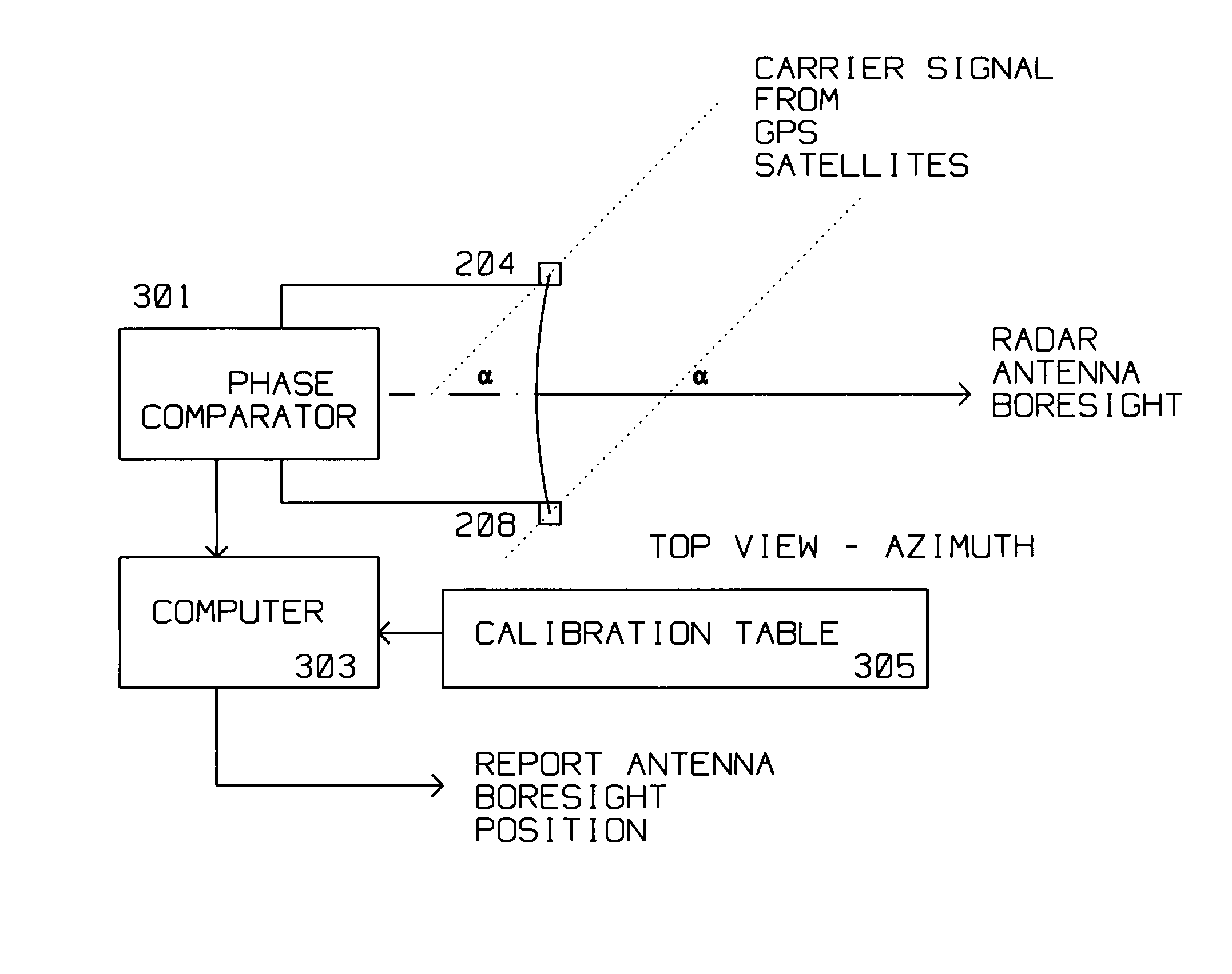
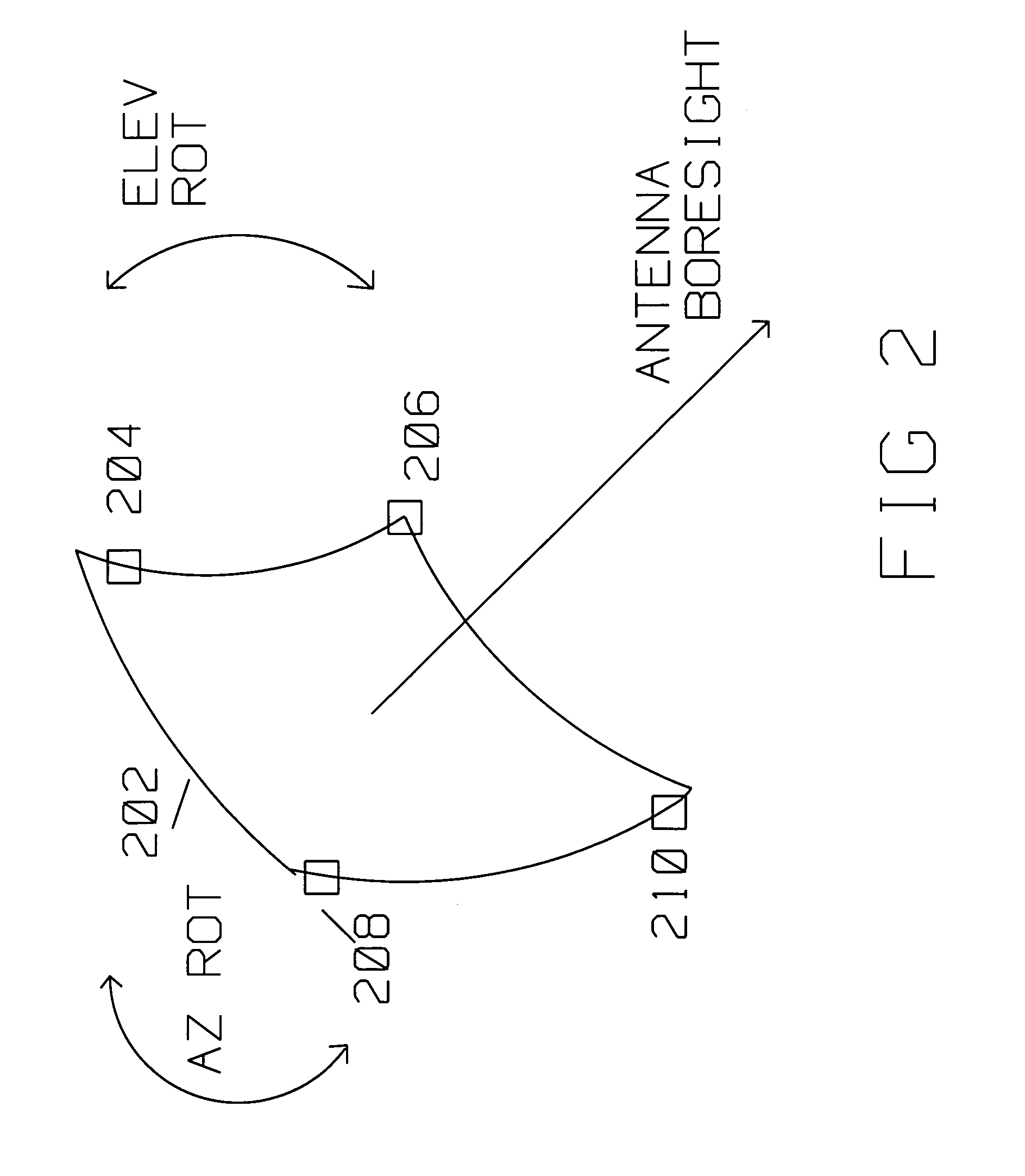
Technique for accurate estimate of large antenna inertial two dimensional orientation using relative GPS spatial phase
PatentActiveUS7298325B2
Innovation
- The use of a radar antenna with multiple GPS satellite signal receiving antennas positioned equidistantly along its periphery, connected to a phase comparator to measure differential phase differences, allowing for accurate determination of boresight angle through phase measurements from multiple GPS satellites, resolving ambiguities and improving orientation accuracy.

Synthetic aperture radar mineral prospector
PatentWO2016168412A1
Innovation
- A synthetic aperture radar system using a ground-penetrating phase-coherent radar system with a moving platform that sends radar signals through an underground volume, collects returns, and processes them to identify subsurface features by comparing characteristics with reference data, allowing for non-contact, efficient detection of mineral resources.


Environmental Impact Assessment for Remote Sensing Operations
Remote sensing operations utilizing Synthetic Aperture Radar (SAR) and magnetometer technologies for resource mapping present distinct environmental considerations that require comprehensive assessment. Both technologies operate through fundamentally different mechanisms, resulting in varying degrees of environmental interaction and potential ecological impact during deployment and operation phases.
SAR systems generate active electromagnetic pulses in microwave frequencies, typically ranging from 1 to 40 GHz, which penetrate atmospheric conditions and interact with surface materials. The electromagnetic emissions from SAR platforms, whether satellite-based or airborne, contribute to the overall electromagnetic field environment. While these emissions are generally considered low-power compared to commercial broadcasting systems, their cumulative effect in sensitive ecological areas requires evaluation, particularly regarding potential interference with wildlife navigation systems and breeding patterns.
Magnetometer operations, conversely, function as passive sensing systems that detect variations in Earth's magnetic field without emitting electromagnetic radiation. This passive nature significantly reduces direct environmental impact during data acquisition phases. However, magnetometer surveys often require closer proximity to target areas, potentially necessitating low-altitude flights or ground-based operations that may cause temporary disturbance to local ecosystems through noise pollution and physical presence.
The operational footprint of these technologies differs substantially in terms of energy consumption and carbon emissions. SAR systems demand considerable power for signal generation and processing, particularly in spaceborne applications where power efficiency directly correlates with mission sustainability. Magnetometer systems typically exhibit lower power requirements, though high-resolution surveys may necessitate extended operational periods or multiple platform deployments.
Ground-based infrastructure requirements also present environmental considerations. SAR operations often require substantial ground stations for data reception and processing, involving permanent installations that may impact local land use patterns. Magnetometer surveys frequently utilize temporary field stations with minimal infrastructure requirements, reducing long-term environmental commitments.
Data processing and storage demands for both technologies contribute to indirect environmental impacts through computational resource utilization. SAR data processing requires intensive computational power due to complex signal processing algorithms, while magnetometer data analysis typically involves less computationally demanding procedures, resulting in lower energy consumption for equivalent survey coverage.
The temporal aspects of environmental impact vary between technologies. SAR systems can achieve rapid area coverage with minimal repeated exposure, while magnetometer surveys may require extended operational periods or multiple passes to achieve comparable data quality, potentially prolonging environmental exposure duration in sensitive areas.
Data Fusion Strategies for Enhanced Resource Detection
Data fusion represents a critical advancement in resource mapping, combining the complementary strengths of synthetic aperture radar and magnetometer technologies to overcome individual sensor limitations. The integration of SAR's high-resolution surface imaging capabilities with magnetometer's subsurface magnetic anomaly detection creates a comprehensive detection framework that significantly enhances resource identification accuracy and reduces false positive rates.
Multi-sensor fusion architectures typically employ three primary approaches: pixel-level, feature-level, and decision-level integration. Pixel-level fusion directly combines raw SAR backscatter coefficients with magnetic field intensity measurements through mathematical operations such as weighted averaging or principal component analysis. This approach preserves maximum information content but requires precise spatial registration and normalization of disparate data types.
Feature-level fusion extracts characteristic parameters from each sensor before integration. SAR-derived features include texture metrics, coherence patterns, and polarimetric decomposition parameters, while magnetometer features encompass gradient magnitudes, analytic signal amplitudes, and spectral characteristics. Advanced machine learning algorithms, particularly convolutional neural networks and support vector machines, effectively correlate these multi-dimensional feature spaces to identify resource signatures.
Decision-level fusion operates on classification outputs from individual sensors, combining probability maps or confidence scores through Bayesian inference, Dempster-Shafer theory, or fuzzy logic frameworks. This approach accommodates varying sensor reliabilities and provides uncertainty quantification, enabling risk-based decision making in resource exploration campaigns.
Adaptive fusion strategies dynamically adjust integration weights based on local data quality metrics, environmental conditions, and geological context. These systems monitor signal-to-noise ratios, atmospheric interference levels, and terrain characteristics to optimize fusion parameters in real-time, ensuring consistent performance across diverse operational scenarios.
Temporal fusion techniques leverage multi-temporal SAR acquisitions alongside repeated magnetometer surveys to distinguish permanent geological features from transient surface phenomena. Change detection algorithms identify stable anomalies indicative of subsurface resources while filtering out seasonal variations and anthropogenic interference patterns that could compromise detection accuracy.
Unlock deeper insights with PatSnap Eureka Quick Research — get a full tech report to explore trends and direct your research. Try now!
Generate Your Research Report Instantly with AI Agent
Supercharge your innovation with PatSnap Eureka AI Agent Platform!