

Location Aided Routing in Wildlife Tracking: Implementation
MAR 17, 20269 MIN READ
Generate Your Research Report Instantly with AI Agent
PatSnap Eureka helps you evaluate technical feasibility & market potential.
Wildlife Tracking LAR Background and Objectives
Wildlife tracking has evolved from simple observation methods to sophisticated technological systems that monitor animal movements, behaviors, and habitat utilization patterns. Traditional wildlife monitoring relied heavily on visual observations, radio telemetry, and basic GPS collars, which provided limited real-time data and suffered from significant coverage gaps. The integration of wireless sensor networks and advanced positioning technologies has revolutionized this field, enabling continuous monitoring of wildlife populations across vast geographical areas.
The emergence of Location Aided Routing protocols represents a significant advancement in wildlife tracking network architectures. These protocols leverage geographical positioning information to optimize data transmission paths between sensor nodes, reducing energy consumption and improving network reliability. As wildlife tracking systems increasingly depend on battery-powered devices deployed in remote environments, efficient routing mechanisms become critical for extending operational lifespans and maintaining consistent data collection.
Current wildlife tracking systems face numerous challenges including limited battery life, harsh environmental conditions, intermittent connectivity, and the need for real-time data transmission. Animals often traverse areas with poor network coverage, creating data transmission bottlenecks that can result in critical information loss. Additionally, the dynamic nature of wildlife movement patterns requires adaptive routing strategies that can accommodate rapidly changing network topologies.
The primary objective of implementing Location Aided Routing in wildlife tracking systems is to establish robust, energy-efficient communication networks that can reliably transmit tracking data from remote locations to research centers. This implementation aims to minimize packet loss, reduce transmission delays, and optimize power consumption across the entire sensor network infrastructure.
Secondary objectives include developing adaptive routing algorithms that can dynamically adjust to animal movement patterns, environmental changes, and network topology variations. The system should demonstrate improved scalability to accommodate growing numbers of tracked animals while maintaining consistent performance metrics. Furthermore, the implementation seeks to integrate seamlessly with existing wildlife monitoring infrastructure and provide enhanced data quality for ecological research applications.
Long-term strategic goals encompass advancing the understanding of animal behavior patterns through improved data collection capabilities, supporting conservation efforts with more accurate population monitoring, and establishing standardized protocols for wildlife tracking network deployments. The successful implementation of LAR protocols in wildlife tracking applications could serve as a foundation for broader ecological monitoring systems and contribute to global biodiversity conservation initiatives.
Market Demand for Advanced Wildlife Monitoring Systems
The global wildlife monitoring market has experienced substantial growth driven by increasing environmental awareness and conservation imperatives. Traditional wildlife tracking methods, including radio telemetry and GPS collaring, have evolved significantly with technological advancements. However, these conventional approaches face limitations in data transmission efficiency, battery life optimization, and real-time monitoring capabilities, creating substantial demand for innovative solutions.
Conservation organizations worldwide are actively seeking advanced monitoring systems that can provide continuous, reliable wildlife tracking with minimal human intervention. The demand stems from critical needs including endangered species protection, migration pattern analysis, habitat utilization studies, and human-wildlife conflict mitigation. Research institutions require sophisticated tracking solutions capable of collecting high-resolution spatial and temporal data for comprehensive ecological studies.
Government agencies and wildlife management authorities represent a significant market segment demanding scalable monitoring solutions. These organizations require systems capable of tracking multiple species across vast geographical areas while maintaining cost-effectiveness. The integration of location-aided routing technologies addresses these requirements by optimizing data transmission paths, reducing power consumption, and enhancing overall system reliability.
Commercial applications have emerged as a growing market segment, particularly in eco-tourism and wildlife park management. Private conservation initiatives and wildlife reserves seek advanced monitoring systems to enhance visitor experiences while ensuring animal welfare. These applications demand user-friendly interfaces, real-time data visualization, and robust communication networks capable of operating in remote environments.
The market demand is further amplified by regulatory requirements and international conservation agreements mandating systematic wildlife monitoring. Climate change research initiatives require long-term wildlife tracking data to understand ecosystem responses and species adaptation patterns. This regulatory landscape creates sustained demand for reliable, technologically advanced monitoring solutions.
Technological convergence has created opportunities for integrated monitoring platforms combining satellite communication, cellular networks, and mesh networking capabilities. The demand for interoperable systems that can seamlessly integrate with existing conservation databases and research platforms continues to grow, driving innovation in location-aided routing implementations for wildlife tracking applications.
Current LAR Implementation Challenges in Wildlife Networks
Location Aided Routing protocols face significant implementation challenges when deployed in wildlife tracking networks, primarily due to the unique characteristics of animal movement patterns and harsh environmental conditions. Traditional LAR algorithms assume relatively predictable mobility patterns, but wildlife behavior exhibits high variability, seasonal migrations, and unpredictable territorial changes that complicate route prediction accuracy.
Power consumption represents a critical constraint in wildlife tracking implementations. Battery-powered sensor nodes attached to animals must operate for extended periods without maintenance, yet LAR protocols require frequent location updates and route calculations that drain energy resources rapidly. The computational overhead of maintaining location databases and performing geographic calculations becomes particularly problematic for resource-constrained devices.
Network connectivity issues pose substantial challenges in wildlife environments. Animals often traverse remote areas with sparse node density, creating frequent network partitions and extended communication gaps. LAR protocols struggle to maintain accurate location information when nodes move beyond communication range for extended periods, leading to outdated routing tables and failed packet delivery attempts.
Environmental interference significantly impacts LAR implementation effectiveness. Dense vegetation, terrain variations, and weather conditions affect both GPS accuracy and wireless signal propagation. Location estimation errors propagate through the routing algorithm, causing suboptimal path selection and increased packet loss rates. The dynamic nature of wildlife habitats introduces additional signal attenuation and multipath effects.
Scalability concerns emerge when implementing LAR in large wildlife populations. As the number of tracked animals increases, the overhead of maintaining location information for all network nodes grows exponentially. Broadcasting location updates consumes significant bandwidth and creates network congestion, particularly during animal aggregation events such as migration or feeding gatherings.
Protocol adaptation challenges arise from the diverse mobility characteristics of different species. A LAR implementation optimized for slow-moving terrestrial animals may perform poorly when applied to fast-flying birds or aquatic species. The heterogeneous nature of wildlife networks requires adaptive algorithms capable of handling multiple mobility models simultaneously, increasing implementation complexity and resource requirements.
Existing LAR Solutions for Animal Movement Monitoring
01 Geographic routing protocols for mobile ad-hoc networks
Geographic routing protocols utilize location information of nodes to make forwarding decisions in mobile ad-hoc networks (MANETs). These protocols use position data obtained from GPS or other positioning systems to determine the next hop for packet forwarding. The routing decisions are based on the physical proximity of nodes rather than traditional network topology, which reduces routing overhead and improves scalability in dynamic network environments.- Geographic routing protocols for mobile ad-hoc networks: Geographic routing protocols utilize location information of nodes to make forwarding decisions in mobile ad-hoc networks (MANETs). These protocols use position data obtained from GPS or other positioning systems to determine the next hop for packet forwarding. The routing decisions are based on the physical locations of nodes rather than traditional network topology information, which reduces routing overhead and improves scalability in dynamic network environments.
- Location-based route optimization and path selection: Route optimization techniques leverage geographic location data to select optimal paths for data transmission. These methods calculate the most efficient routes by considering factors such as distance, node density, and geographic proximity. The optimization algorithms evaluate multiple potential paths and select routes that minimize transmission delays and maximize delivery success rates based on spatial relationships between network nodes.
- Position-aware forwarding mechanisms: Position-aware forwarding strategies use real-time location information to make intelligent packet forwarding decisions. These mechanisms incorporate geographic coordinates and movement patterns to predict node availability and select appropriate next-hop neighbors. The forwarding process adapts to node mobility and network topology changes by continuously updating position information and adjusting routing decisions accordingly.
- Location service and position management systems: Location service systems provide infrastructure for storing, updating, and retrieving position information of mobile nodes in the network. These systems maintain distributed databases or use hierarchical structures to manage location data efficiently. The position management mechanisms handle location updates, queries, and coordinate distribution to support routing protocols that depend on accurate geographic information.
- Hybrid location-assisted routing approaches: Hybrid routing approaches combine location-based techniques with other routing strategies to enhance performance and reliability. These methods integrate geographic information with topology-based routing, predictive algorithms, or quality-of-service parameters. The hybrid solutions balance the benefits of position-aware routing with additional metrics to handle various network scenarios, including areas with sparse node density or limited location accuracy.
02 Location-based routing in vehicular networks
Vehicular networks employ location-aided routing to enable efficient communication between vehicles and infrastructure. The routing mechanisms leverage real-time position information to establish communication paths that account for vehicle mobility patterns and road topology. This approach enhances routing reliability and reduces latency in vehicle-to-vehicle and vehicle-to-infrastructure communications, supporting applications such as traffic management and safety systems.Expand Specific Solutions03 Predictive routing using location history and trajectory
Advanced routing schemes incorporate historical location data and predicted movement trajectories to optimize route selection. By analyzing past movement patterns and estimating future positions, these systems can proactively establish routing paths before they are needed. This predictive approach minimizes route discovery delays and improves overall network performance in scenarios with predictable mobility patterns.Expand Specific Solutions04 Hybrid routing combining location and topology information
Hybrid routing protocols integrate both geographic location data and network topology information to achieve robust routing performance. These protocols adaptively switch between location-based and topology-based routing depending on network conditions and data availability. The combination approach provides fallback mechanisms when location information is unavailable or inaccurate, ensuring continuous connectivity and improved routing reliability across diverse network scenarios.Expand Specific Solutions05 Location privacy and security in geographic routing
Security mechanisms for location-aided routing address privacy concerns and protect against location-based attacks. These techniques include location obfuscation, encrypted position sharing, and authentication protocols that verify location claims while preserving user privacy. The security frameworks prevent malicious nodes from exploiting location information for attacks such as position spoofing or traffic analysis, ensuring secure and privacy-preserving geographic routing operations.Expand Specific Solutions
Key Players in Wildlife Tracking Technology Industry
The location-aided routing technology for wildlife tracking is in an emerging development stage, with the market experiencing rapid growth driven by increasing conservation needs and IoT adoption. The market size remains relatively niche but shows significant expansion potential as environmental monitoring becomes more critical globally. Technology maturity varies considerably across different players in this space. Academic institutions like MIT, Zhejiang University, and University of Electronic Science & Technology of China are advancing fundamental research in routing algorithms and sensor networks. Technology companies demonstrate varying levels of implementation readiness - established players like Huawei Technologies, Qualcomm, and Nokia Technologies possess mature networking and communication infrastructure capabilities that can be adapted for wildlife tracking applications. Specialized companies such as DJI and Vence Corp. show more targeted solutions, with DJI's drone technology and Vence's livestock management systems representing practical implementations. However, most solutions remain in prototype or early deployment phases, indicating that while the underlying technologies are maturing, integrated location-aided routing systems specifically designed for wildlife tracking require further development to achieve commercial viability and widespread adoption.
ZTE Corp.
Technical Solution: ZTE has implemented location-aided routing systems specifically designed for wildlife monitoring applications using their advanced wireless communication technologies. Their solution combines GPS tracking with mesh networking protocols that adapt routing decisions based on real-time location updates from tagged animals. The system employs dynamic routing algorithms that consider geographical constraints, signal strength variations, and energy efficiency to optimize data transmission paths. ZTE's approach integrates with their 5G network infrastructure to provide reliable connectivity even in remote wilderness areas, utilizing beamforming and network slicing technologies to ensure consistent data delivery from wildlife tracking devices.
Strengths: Robust wireless infrastructure, cost-effective solutions, strong mesh networking capabilities. Weaknesses: Limited market presence in some regions, dependency on network coverage.
SZ DJI Technology Co., Ltd.
Technical Solution: DJI has implemented location-aided routing in their wildlife tracking solutions by integrating drone-based monitoring systems with ground-based sensor networks. Their approach uses aerial vehicles equipped with GPS and communication relays to create dynamic routing paths for wildlife tracking data. The system employs real-time location updates from both drones and ground sensors to optimize data transmission routes, particularly useful for tracking animals in difficult terrain where traditional communication infrastructure is limited. DJI's solution includes automated flight path planning based on animal movement predictions and environmental conditions, ensuring continuous connectivity and data collection even in remote wilderness areas.
Strengths: Innovative aerial-based solutions, excellent integration capabilities, strong autonomous systems. Weaknesses: Weather dependency, regulatory restrictions on drone operations, limited battery life.
Core LAR Algorithms for Wildlife Sensor Networks
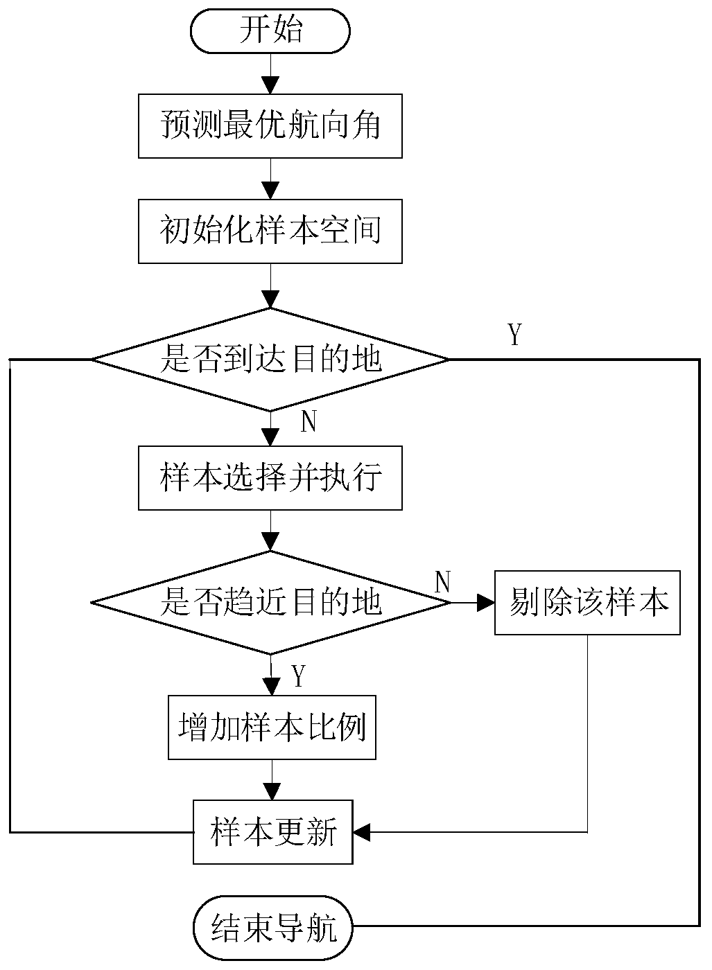
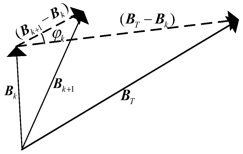
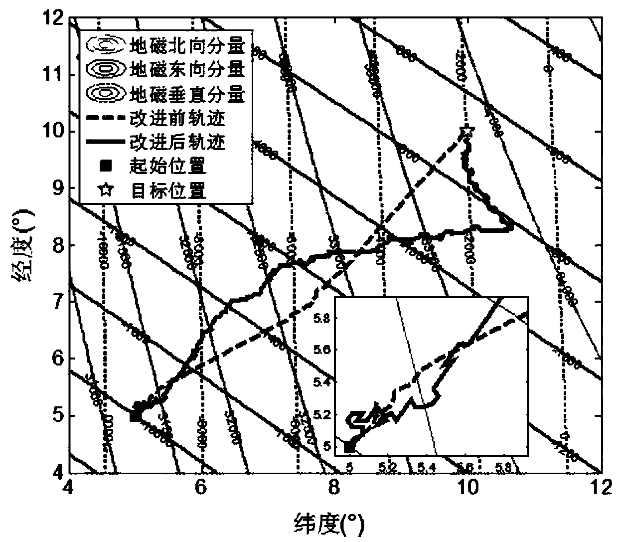
Bionic navigation algorithm based on geomagnetic gradient aided multi-objective evolutionary search
PatentInactiveCN111307143A
Innovation
- A multi-objective evolutionary search bionic navigation algorithm based on geomagnetic gradient assistance is used to obtain geomagnetic parameters of the carrier's current and target positions, calculate gradient information, predict heading angles, constrain the sample space of the evolutionary algorithm, update samples in real time, and optimize evaluation criteria to improve navigation. Path accuracy and efficiency.

Positioning method and apparatus, and positioning system
PatentWO2021120110A1
Innovation
- A hybrid wireless system that uses low-power Bluetooth BLE MESH network and cellular mobile communication network, and achieves high-precision positioning of target objects through the communication of multiple Bluetooth positioning base stations with MESH gateways and positioning servers, reducing the cost of installing cellular for each target object. The demand for mobile communication modules reduces construction and maintenance costs.


Environmental Regulations for Wildlife Tracking Devices
Wildlife tracking devices operate within a complex regulatory framework that varies significantly across jurisdictions and ecosystems. International conventions such as the Convention on Migratory Species (CMS) and the Convention on International Trade in Endangered Species (CITES) establish foundational principles for wildlife monitoring activities. These agreements mandate that tracking technologies must not interfere with natural behaviors or migration patterns, requiring devices to meet strict weight-to-body-mass ratios and energy consumption standards.
National wildlife protection agencies impose specific technical requirements for tracking device deployment. In the United States, the Federal Communications Commission (FCC) regulates radio frequency emissions from tracking devices, while the Fish and Wildlife Service oversees animal welfare aspects. European Union directives require compliance with the Radio Equipment Directive (RED) and mandate environmental impact assessments for large-scale tracking programs. These regulations directly influence location-aided routing protocols by restricting transmission power levels and frequency bands available for device communication.
Environmental protection standards focus heavily on device lifecycle management and ecological impact mitigation. Regulations require tracking devices to use biodegradable materials where possible and implement fail-safe mechanisms to prevent environmental contamination. Battery disposal protocols mandate the use of non-toxic power sources and automatic shutdown procedures when devices reach end-of-life status. These requirements significantly impact routing algorithm design, as devices must optimize energy consumption to extend operational lifespan while maintaining regulatory compliance.
Permitting processes for wildlife tracking research involve multiple regulatory layers, from local wildlife management authorities to international research coordination bodies. Research institutions must demonstrate that location-aided routing implementations do not create electromagnetic interference with other wildlife or disrupt ecosystem balance. Data privacy regulations, particularly regarding endangered species location information, require encrypted communication protocols and restricted data access frameworks.
Emerging regulations address the growing concern of electronic waste in natural environments. New standards mandate remote device deactivation capabilities and biodegradable housing materials for long-term deployments. These evolving requirements are driving innovation in routing protocols that can maintain network connectivity even as individual devices are remotely disabled or naturally decompose, ensuring sustainable wildlife monitoring practices.
Energy Efficiency Considerations in Remote LAR Systems
Energy efficiency represents a critical design consideration for Location Aided Routing systems deployed in wildlife tracking applications, particularly given the remote and often inaccessible nature of deployment environments. The fundamental challenge lies in balancing comprehensive tracking capabilities with extended operational lifespans, as battery replacement or maintenance in wilderness settings proves both costly and logistically complex.
Power consumption in remote LAR systems stems from multiple sources, with wireless communication typically accounting for 60-70% of total energy expenditure. GPS positioning modules contribute an additional 20-25%, while sensor data collection and processing consume the remaining power budget. The intermittent nature of wildlife movement patterns creates opportunities for intelligent power management through adaptive duty cycling and context-aware activation strategies.
Battery technology selection significantly impacts system longevity, with lithium-thionyl chloride cells offering superior energy density and temperature tolerance compared to conventional lithium-ion alternatives. Solar energy harvesting presents viable supplementation in open habitats, though dense forest canopies and seasonal variations limit effectiveness. Advanced energy harvesting techniques, including kinetic energy capture from animal movement and thermoelectric generation, show promise but remain largely experimental.
Communication protocol optimization offers substantial energy savings through intelligent data aggregation and transmission scheduling. Implementing store-and-forward mechanisms reduces transmission frequency, while adaptive transmission power control based on link quality minimizes unnecessary energy expenditure. Multi-hop networking capabilities enable strategic relay positioning to reduce individual node transmission requirements.
Sleep mode management represents another crucial efficiency factor, with modern microcontrollers achieving sub-microampere standby currents. Dynamic voltage scaling and clock frequency adjustment based on computational demands can reduce processing energy consumption by up to 40%. Temperature compensation algorithms ensure consistent performance across varying environmental conditions while minimizing power-intensive recalibration cycles.
System-level energy budgeting requires careful consideration of tracking resolution requirements versus operational longevity. High-frequency position updates provide detailed behavioral insights but dramatically reduce deployment duration. Implementing intelligent sampling strategies based on movement detection and behavioral state classification optimizes the trade-off between data quality and energy consumption, potentially extending operational life from months to multiple years.
Unlock deeper insights with PatSnap Eureka Quick Research — get a full tech report to explore trends and direct your research. Try now!
Generate Your Research Report Instantly with AI Agent
Supercharge your innovation with PatSnap Eureka AI Agent Platform!