Optimize Location Aided Routing for Autonomous Vehicles
MAR 17, 20269 MIN READ
Generate Your Research Report Instantly with AI Agent
Patsnap Eureka helps you evaluate technical feasibility & market potential.
Autonomous Vehicle Location Routing Background and Objectives
The evolution of autonomous vehicle technology has fundamentally transformed transportation paradigms, with location-aided routing emerging as a critical component for achieving safe and efficient autonomous navigation. Traditional GPS-based navigation systems, while adequate for human drivers, prove insufficient for the precision requirements of autonomous vehicles operating in complex urban environments, highway scenarios, and challenging weather conditions.
Location-aided routing represents the convergence of multiple technological domains including high-precision positioning systems, real-time traffic analytics, vehicle-to-everything communication protocols, and advanced path optimization algorithms. This integration addresses the fundamental challenge of enabling autonomous vehicles to make intelligent routing decisions that consider not only static map data but also dynamic environmental factors, traffic patterns, and vehicle-specific constraints.
The primary objective of optimizing location-aided routing systems centers on achieving sub-meter positioning accuracy while maintaining real-time computational efficiency. Current autonomous vehicles require positioning precision within 10-30 centimeters for safe lane-keeping and obstacle avoidance, significantly exceeding the 3-5 meter accuracy provided by standard GPS systems. This precision gap necessitates the integration of complementary positioning technologies including Real-Time Kinematic GPS, inertial measurement units, LiDAR-based simultaneous localization and mapping, and computer vision systems.
Beyond positioning accuracy, the optimization objectives encompass minimizing computational latency to enable real-time decision making, reducing energy consumption through efficient route planning, and enhancing system reliability under diverse operational conditions. The routing algorithms must simultaneously optimize multiple parameters including travel time, fuel efficiency, passenger comfort, and safety margins while adapting to dynamic traffic conditions and infrastructure limitations.
The strategic importance of this technology extends beyond individual vehicle performance to encompass broader transportation ecosystem benefits including traffic flow optimization, reduced congestion, enhanced road safety, and improved urban mobility efficiency. As autonomous vehicle deployment scales globally, the effectiveness of location-aided routing systems will directly impact public acceptance, regulatory approval, and commercial viability of autonomous transportation solutions.
Market Demand for Optimized AV Navigation Systems
The autonomous vehicle market is experiencing unprecedented growth driven by increasing urbanization, traffic congestion, and the urgent need for safer transportation solutions. Major metropolitan areas worldwide are grappling with deteriorating traffic conditions, creating substantial demand for intelligent navigation systems that can optimize route planning and reduce travel times. The convergence of advanced sensor technologies, high-precision mapping, and real-time data processing capabilities has created a fertile environment for location-aided routing solutions.
Consumer expectations for autonomous vehicles extend far beyond basic self-driving capabilities. Modern users demand seamless integration with smart city infrastructure, predictive traffic management, and personalized routing preferences that consider factors such as fuel efficiency, scenic routes, or fastest arrival times. This shift in consumer behavior is driving automotive manufacturers and technology companies to invest heavily in sophisticated navigation algorithms that can adapt to dynamic road conditions and user preferences.
The commercial transportation sector represents a particularly lucrative market segment for optimized AV navigation systems. Fleet operators, logistics companies, and ride-sharing services are actively seeking solutions that can minimize operational costs through intelligent route optimization. These systems must handle complex multi-vehicle coordination, real-time cargo tracking, and dynamic rerouting capabilities while maintaining safety standards and regulatory compliance.
Regulatory frameworks across different regions are increasingly mandating advanced safety features and connectivity standards for autonomous vehicles. Government initiatives promoting smart city development and intelligent transportation systems are creating additional market opportunities for location-aided routing technologies. These regulatory drivers are accelerating adoption timelines and establishing technical requirements that navigation system providers must meet.
The integration of emerging technologies such as vehicle-to-everything communication, edge computing, and artificial intelligence is expanding the scope of what optimized navigation systems can achieve. Market demand is shifting toward comprehensive mobility solutions that can seamlessly interact with traffic management systems, emergency services, and other connected infrastructure components. This technological evolution is creating new revenue streams and business models for companies developing advanced routing solutions.
Enterprise customers are demonstrating strong interest in navigation systems that can provide detailed analytics, predictive maintenance alerts, and operational insights. The ability to collect and analyze location data for business intelligence purposes is becoming a key differentiator in the market, driving demand for more sophisticated routing platforms that extend beyond basic navigation functionality.
Current State and Challenges of Location-Aided Routing
Location-aided routing for autonomous vehicles represents a critical intersection of positioning technologies, real-time data processing, and intelligent transportation systems. Currently, the field leverages a combination of Global Navigation Satellite Systems (GNSS), cellular networks, Vehicle-to-Everything (V2X) communications, and high-definition mapping to enable precise vehicle positioning and route optimization. Leading implementations integrate GPS/GLONASS/Galileo signals with inertial measurement units, LiDAR sensors, and computer vision systems to achieve centimeter-level accuracy in urban environments.
The technological landscape is dominated by hybrid approaches that combine multiple positioning methodologies to overcome individual system limitations. Advanced implementations utilize Real-Time Kinematic (RTK) positioning, Simultaneous Localization and Mapping (SLAM) algorithms, and machine learning-based prediction models to enhance routing accuracy. Major automotive manufacturers and technology companies have developed proprietary solutions that integrate cloud-based processing with edge computing capabilities to handle the massive data volumes required for real-time route optimization.
Despite significant technological advances, several fundamental challenges persist in location-aided routing systems. Signal degradation in urban canyons, tunnels, and dense foliage areas continues to compromise positioning accuracy, leading to suboptimal routing decisions. The integration of heterogeneous data sources from multiple sensors creates computational complexity that strains current processing capabilities, particularly in resource-constrained vehicular environments.
Latency issues represent another critical bottleneck, as autonomous vehicles require sub-millisecond response times for safety-critical routing decisions. Current communication infrastructures often struggle to meet these stringent requirements, especially in areas with limited 5G coverage or high network congestion. The dynamic nature of traffic conditions, weather variations, and temporary road closures further complicates real-time route optimization algorithms.
Privacy and security concerns pose additional constraints on system deployment. Location data sensitivity requires robust encryption and anonymization protocols, which can introduce computational overhead and reduce system responsiveness. Cybersecurity vulnerabilities in V2X communications and cloud-based routing services create potential attack vectors that could compromise vehicle safety and passenger privacy.
Scalability challenges emerge as autonomous vehicle adoption increases, with current routing algorithms struggling to handle massive concurrent requests while maintaining optimal performance. The geographic distribution of technological capabilities varies significantly, with rural and developing regions lacking the infrastructure density necessary for reliable location-aided routing implementation.
Existing Location-Aided Routing Solutions for AVs
01 Geographic position-based routing protocol optimization
Routing protocols can be optimized by utilizing geographic position information of nodes to make intelligent forwarding decisions. This approach reduces routing overhead by eliminating the need for complete route discovery and maintenance. Position-based routing algorithms select next-hop nodes based on their proximity to the destination, improving routing efficiency in mobile ad-hoc networks and vehicular networks. The geographic information enables greedy forwarding strategies and reduces control message overhead.- Geographic position-based routing protocol optimization: Routing protocols can be optimized by utilizing geographic position information of nodes to make intelligent forwarding decisions. This approach reduces routing overhead and improves packet delivery efficiency by selecting next-hop nodes based on their proximity to the destination. The geographic information enables more direct path selection and reduces the need for extensive route discovery processes.
- Dynamic route selection using real-time location data: Real-time location data can be leveraged to dynamically adjust routing paths based on current network conditions and node positions. This method allows for adaptive routing that responds to changes in network topology, node mobility, and traffic patterns. The system continuously updates routing decisions to maintain optimal paths and avoid congested or failed routes.
- Multi-path routing with location awareness: Location-aware multi-path routing techniques establish multiple routes between source and destination nodes based on geographic distribution. This approach enhances network reliability and load balancing by distributing traffic across geographically diverse paths. The method reduces the impact of single point failures and improves overall network throughput.
- Location-based routing for mobile ad-hoc networks: Specialized routing algorithms designed for mobile ad-hoc networks utilize location information to handle frequent topology changes caused by node mobility. These algorithms predict node movement patterns and proactively adjust routes to maintain connectivity. The approach minimizes route breakage and reduces latency in highly dynamic network environments.
- Energy-efficient location-aided routing: Energy consumption can be optimized in routing protocols by incorporating location information to select paths that minimize transmission power and extend network lifetime. This technique considers both geographic distance and remaining energy levels of intermediate nodes when making routing decisions. The approach is particularly beneficial for battery-powered devices in wireless sensor networks and IoT applications.
02 Dynamic route optimization using real-time location data
Real-time location information can be leveraged to dynamically adjust routing paths based on current network conditions and node positions. This method continuously updates routing decisions as nodes move, ensuring optimal path selection. The system monitors location changes and recalculates routes to maintain connectivity and minimize latency. Dynamic optimization adapts to topology changes and traffic patterns, improving overall network performance.Expand Specific Solutions03 Multi-path routing with location awareness
Location-aided routing can establish multiple paths between source and destination nodes to enhance reliability and load balancing. By considering geographic distribution of nodes, the system can identify diverse routing paths that minimize interference and congestion. This approach provides fault tolerance through path redundancy and improves throughput by distributing traffic across multiple routes. The location information helps in selecting paths with minimal overlap and optimal geographic spread.Expand Specific Solutions04 Energy-efficient routing based on node location
Geographic location information can be utilized to optimize energy consumption in routing decisions. By selecting routes that minimize transmission distances and reduce the number of hops, the system extends network lifetime. Location-aware algorithms can identify energy-efficient paths that balance load among nodes and avoid depleting battery resources of specific nodes. This optimization considers both geographic proximity and remaining energy levels to make sustainable routing choices.Expand Specific Solutions05 Predictive routing using location trajectory analysis
Historical and predicted location trajectories of mobile nodes can be analyzed to proactively optimize routing paths. By forecasting future positions based on movement patterns, the system can establish routes that remain stable over time. This predictive approach reduces route breakage and handover frequency in mobile networks. The method anticipates topology changes and preemptively adjusts routing tables to maintain connectivity and minimize disruption.Expand Specific Solutions
Key Players in AV Routing and Navigation Industry
The autonomous vehicle location-aided routing technology sector represents a rapidly evolving competitive landscape characterized by significant market fragmentation and varying technological maturity levels. The industry is currently in a growth phase, driven by substantial investments from automotive OEMs, technology giants, and specialized startups, with market size expanding as regulatory frameworks develop globally. Technology maturity varies considerably across players, with established companies like Waymo, GM Cruise Holdings, and Aurora Operations leading in comprehensive autonomous driving systems, while automotive manufacturers such as BMW, Toyota, Nissan, and Guangzhou Automobile Group focus on integrating routing optimization into their vehicle platforms. Technology suppliers like Robert Bosch, DeepMap, and Beijing Sensetime provide specialized mapping and AI solutions, while research institutions including South China University of Technology and Beijing Jiaotong University contribute foundational research, creating a diverse ecosystem spanning from early-stage development to commercial deployment.
Baidu USA LLC
Technical Solution: Baidu has implemented Apollo's location-aided routing framework that leverages AI-powered route optimization combined with high-definition maps and real-time traffic analysis. Their system utilizes deep learning models to process multi-modal sensor inputs including GPS, LiDAR, and camera data for precise localization and route planning. The Apollo routing module incorporates predictive analytics to anticipate traffic congestion and road hazards, enabling proactive route adjustments. The platform supports cloud-based route computation with edge processing capabilities, allowing vehicles to maintain routing functionality even with limited connectivity. Baidu's approach emphasizes integration with smart city infrastructure and V2X communication protocols.
Strengths: Strong AI capabilities and comprehensive open-source platform with extensive Chinese market deployment experience. Weaknesses: Limited global market presence and potential data privacy concerns in international markets.
Robert Bosch GmbH
Technical Solution: Bosch has developed a location-aided routing solution that focuses on sensor fusion and predictive route optimization for autonomous vehicles. Their system combines GPS positioning with inertial measurement units, wheel speed sensors, and camera-based localization to achieve centimeter-level accuracy in route following. The Bosch routing algorithm incorporates real-time traffic data, weather conditions, and vehicle performance parameters to optimize fuel efficiency and travel time. Their approach emphasizes robust performance in challenging environments such as tunnels, urban canyons, and areas with poor GPS reception. The system features adaptive routing capabilities that learn from driver behavior patterns and vehicle-specific characteristics to provide personalized route recommendations.
Strengths: Excellent sensor technology integration and robust performance in GPS-denied environments with strong automotive industry partnerships. Weaknesses: Less advanced in AI-driven route optimization compared to tech-focused competitors and limited autonomous driving deployment experience.
Core Innovations in AV Location Optimization Algorithms
Routing optimization method for vehicular self-organized network based on connection probabilities
PatentActiveCN105307232A
Innovation
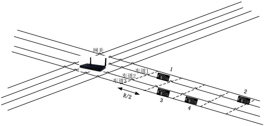
- A route optimization method based on connectivity probability is used to calculate the connectivity probability on each lane through the gateway, select the path with the highest connectivity probability, and record the gateway and lane number in the data packet. It adopts a priority next-hop selection mechanism and considers the node's position, speed and direction to reduce the probability of backoff and improve the effectiveness of routing.


High definition map based localization optimization
PatentPendingUS20220042805A1
Innovation
- A system that uses a localization variant index to select the most suitable localization technique based on driving contexts, integrating sensor data from multiple modalities like camera images, lidar scans, and GPS using Kalman filtering to ensure accurate and efficient navigation.


Safety Standards and Regulations for AV Navigation
The regulatory landscape for autonomous vehicle navigation is rapidly evolving as governments worldwide grapple with establishing comprehensive safety frameworks. Current standards primarily focus on functional safety requirements, with ISO 26262 serving as the foundational automotive safety standard, while emerging regulations like the UNECE WP.29 framework address automated driving systems specifically. These standards emphasize risk assessment, hazard analysis, and systematic safety validation processes for location-aided routing systems.
In the United States, the National Highway Traffic Safety Administration has established voluntary guidance through Federal Automated Vehicles Policy, while individual states maintain varying regulatory approaches. California's Department of Motor Vehicles requires extensive testing documentation and safety assessments for autonomous vehicle deployment, including specific requirements for navigation system reliability and fail-safe mechanisms. The Federal Motor Vehicle Safety Standards are being adapted to accommodate advanced routing technologies and their integration with vehicle control systems.
European Union regulations under the Type Approval Framework mandate rigorous testing protocols for automated driving functions, including location-based navigation systems. The European Telecommunications Standards Institute has developed specific standards for vehicle-to-everything communication protocols that directly impact routing optimization capabilities. These regulations require demonstration of system robustness under various environmental conditions and failure scenarios.
Safety certification processes typically involve multi-stage validation including simulation testing, closed-course evaluation, and limited public road trials. Regulatory bodies increasingly require evidence of system performance across diverse geographic conditions, weather scenarios, and traffic patterns. Documentation must demonstrate that location-aided routing systems maintain safety margins even when GPS signals are degraded or unavailable.
Emerging regulatory trends indicate movement toward performance-based standards rather than prescriptive technical requirements. This approach allows innovation in routing optimization while maintaining strict safety outcomes. International harmonization efforts through organizations like the International Organization for Standardization aim to create globally consistent safety frameworks, facilitating cross-border deployment of autonomous vehicle technologies while ensuring uniform safety levels across different jurisdictions.
Privacy and Data Security in Location-Based AV Systems
Privacy and data security represent critical challenges in location-based autonomous vehicle systems, where vehicles continuously collect, process, and transmit sensitive location information. The inherent nature of location-aided routing requires real-time position data sharing between vehicles, infrastructure, and cloud-based services, creating multiple attack vectors and privacy vulnerabilities that must be systematically addressed.
Location data in autonomous vehicles encompasses not only GPS coordinates but also detailed movement patterns, destination preferences, and behavioral analytics. This information can reveal personal habits, work schedules, social relationships, and private activities, making it highly valuable to malicious actors and raising significant privacy concerns among users. The persistent collection and storage of such data create comprehensive digital footprints that extend far beyond traditional transportation needs.
Current security threats in location-based AV systems include data interception during vehicle-to-vehicle communication, man-in-the-middle attacks on vehicle-to-infrastructure networks, and unauthorized access to centralized routing databases. Adversaries may exploit these vulnerabilities to track individual vehicles, manipulate routing decisions, or launch coordinated attacks on traffic management systems. The wireless nature of most AV communications amplifies these risks significantly.
Existing privacy protection mechanisms employ various cryptographic approaches, including homomorphic encryption for secure computation on encrypted location data, differential privacy techniques to add statistical noise while preserving routing functionality, and zero-knowledge proofs for location verification without revealing actual coordinates. These methods attempt to balance privacy requirements with the operational needs of efficient routing algorithms.
Data anonymization strategies focus on removing personally identifiable information from location datasets while maintaining their utility for routing optimization. However, location data presents unique challenges for anonymization due to its spatiotemporal characteristics, which can enable re-identification even after traditional anonymization processes. Advanced techniques like k-anonymity and l-diversity have shown limited effectiveness in location contexts.
Regulatory frameworks such as GDPR in Europe and various state-level privacy laws in the United States impose strict requirements on location data handling, including explicit consent mechanisms, data minimization principles, and the right to deletion. These regulations significantly impact the design and implementation of location-aided routing systems, requiring built-in privacy controls and transparent data governance practices.
Unlock deeper insights with Patsnap Eureka Quick Research — get a full tech report to explore trends and direct your research. Try now!
Generate Your Research Report Instantly with AI Agent
Supercharge your innovation with Patsnap Eureka AI Agent Platform!