

Fixed Wing Drones in Water Resource Management: Data Capture Precision
FEB 13, 20269 MIN READ
Generate Your Research Report Instantly with AI Agent
Patsnap Eureka helps you evaluate technical feasibility & market potential.
Fixed Wing Drone Water Monitoring Background and Objectives
Water resource management has emerged as one of the most critical challenges facing global sustainability, driven by climate change, population growth, and increasing agricultural demands. Traditional monitoring methods, including ground-based surveys and manned aircraft observations, have proven costly, time-consuming, and limited in spatial coverage. The integration of fixed-wing drone technology represents a transformative approach to addressing these limitations, offering unprecedented capabilities for large-scale water resource surveillance and data collection.
Fixed-wing drones distinguish themselves from rotary-wing counterparts through extended flight endurance, broader coverage areas, and superior energy efficiency. These characteristics make them particularly suitable for monitoring expansive water bodies, irrigation systems, watershed areas, and coastal zones. However, the effectiveness of these platforms fundamentally depends on their data capture precision, which encompasses spatial resolution, temporal accuracy, spectral fidelity, and geometric consistency of collected information.
The evolution of sensor technologies has significantly enhanced the potential of fixed-wing drones in water monitoring applications. Modern platforms can integrate multispectral and hyperspectral cameras, thermal imaging sensors, LiDAR systems, and synthetic aperture radar, enabling comprehensive assessment of water quality parameters, surface temperature variations, vegetation health indices, and topographical changes. Despite these technological advances, achieving consistent high-precision data capture remains challenging due to factors including flight altitude constraints, atmospheric conditions, platform stability, and sensor calibration requirements.
The primary objective of advancing fixed-wing drone technology in water resource management centers on optimizing data capture precision to support critical decision-making processes. This includes accurate detection of water pollution incidents, precise measurement of water level fluctuations, reliable assessment of algal bloom development, and detailed mapping of irrigation efficiency. Enhanced precision directly translates to improved resource allocation, early warning capabilities for environmental hazards, and evidence-based policy formulation for sustainable water management practices.
Achieving these objectives requires systematic investigation of technical parameters affecting data quality, including optimal flight planning strategies, sensor integration methodologies, real-time data processing algorithms, and validation protocols against ground-truth measurements. The ultimate goal is establishing standardized frameworks that ensure reproducible, high-precision water monitoring capabilities across diverse geographical contexts and operational scenarios.
Market Demand for Precision Water Resource Data
The global water resource management sector is experiencing a fundamental transformation driven by the urgent need for accurate, real-time hydrological data. Traditional ground-based monitoring methods, while reliable, are increasingly inadequate for addressing the scale and complexity of modern water challenges. Climate change has intensified the frequency of extreme weather events, including prolonged droughts and catastrophic floods, creating unprecedented demand for comprehensive watershed monitoring solutions. Governments, agricultural enterprises, and environmental agencies require precise spatial and temporal data to optimize irrigation systems, predict flood risks, and ensure sustainable water allocation across competing sectors.
Agricultural water consumption represents the largest share of global freshwater use, making precision irrigation management a critical economic driver. Farmers and agribusinesses are actively seeking cost-effective technologies that can provide high-resolution soil moisture mapping, crop water stress indices, and evapotranspiration measurements. The ability to capture multispectral and thermal imagery at centimeter-level accuracy enables targeted irrigation strategies that reduce water waste while maintaining crop yields. This capability directly translates to operational cost savings and improved resource efficiency, particularly in water-scarce regions where every cubic meter of water carries significant economic value.
Urban water utilities and municipal authorities face mounting pressure to modernize aging infrastructure and detect distribution system inefficiencies. Precision aerial data capture enables rapid identification of pipeline leaks, unauthorized water extraction, and surface water contamination sources that would otherwise require extensive manual inspection. The integration of fixed-wing drone platforms with advanced sensor payloads offers scalable solutions for monitoring large reservoir systems, assessing water quality parameters, and tracking sedimentation patterns that affect storage capacity.
Environmental regulatory frameworks are becoming increasingly stringent, requiring detailed documentation of water body conditions, wetland health, and riparian zone integrity. Conservation organizations and government agencies need repeatable, high-precision monitoring protocols to track ecosystem changes over time and validate compliance with environmental protection standards. The demand extends beyond simple visual documentation to include quantitative measurements of water surface elevation, turbidity levels, and vegetation indices that serve as indicators of ecological health.
The convergence of these diverse market needs has created a substantial opportunity for fixed-wing drone technologies that can deliver superior data capture precision across extensive geographic areas while maintaining operational efficiency and cost-effectiveness compared to alternative monitoring approaches.
Current Status and Challenges in Drone-Based Water Sensing
Fixed-wing drones have emerged as valuable platforms for water resource monitoring, offering extended flight duration and broader coverage compared to rotary-wing alternatives. Current deployments primarily utilize multispectral and hyperspectral sensors to capture water quality parameters including chlorophyll concentration, turbidity, temperature distribution, and algal bloom detection. These systems typically operate at altitudes ranging from 100 to 500 meters, achieving spatial resolutions between 5 to 50 centimeters depending on sensor specifications and flight parameters.
The integration of fixed-wing drones with advanced sensing technologies has demonstrated promising results in large-scale water body monitoring. Recent implementations have successfully mapped reservoir systems, river networks, and irrigation channels across areas exceeding 1000 hectares in single missions. Thermal infrared sensors enable detection of temperature anomalies indicating pollution sources or groundwater discharge points, while RGB cameras provide baseline visual documentation for change detection analysis.
Despite these advancements, significant technical challenges persist in achieving consistent data capture precision. Atmospheric conditions including wind turbulence, humidity variations, and cloud cover substantially impact image quality and spectral accuracy. Fixed-wing platforms face particular difficulties maintaining stable flight paths over narrow water bodies or during low-altitude operations required for high-resolution imaging. The inherent forward momentum of fixed-wing designs limits their ability to perform stationary observations or execute tight turning maneuvers necessary for detailed feature inspection.
Sensor calibration remains a critical bottleneck affecting measurement reliability. Radiometric calibration procedures must account for varying solar angles, atmospheric scattering, and water surface reflectance properties that change throughout flight missions. Current calibration protocols often require ground-based reference targets, introducing logistical complexity and temporal gaps between calibration and actual data collection. Water surface glint and wave action further complicate spectral signature extraction, particularly in windy conditions or shallow water environments.
Data georeferencing accuracy presents another substantial challenge. While GPS-INS systems provide positional data, achieving sub-meter accuracy consistently across entire flight missions requires sophisticated post-processing workflows. Image orthorectification becomes particularly complex over water surfaces lacking distinct ground control points, leading to geometric distortions that compromise spatial analysis precision. The temporal resolution requirements for monitoring dynamic water quality events often conflict with the processing time needed to achieve optimal geometric and radiometric corrections.
Existing Data Capture Solutions for Water Resources
01 Advanced sensor integration and calibration systems
Fixed-wing drones utilize sophisticated sensor integration techniques including multi-spectral cameras, LiDAR, and GPS/INS systems with precise calibration mechanisms. These systems employ real-time sensor fusion algorithms to compensate for flight dynamics and environmental factors, ensuring accurate data capture during aerial surveys. Calibration procedures account for lens distortion, sensor alignment, and atmospheric conditions to maintain measurement precision across varying flight conditions.- Advanced sensor integration and calibration systems: Fixed-wing drones utilize sophisticated sensor integration techniques including multi-spectral cameras, LiDAR, and GPS/INS systems to enhance data capture precision. Calibration methods involve real-time sensor fusion algorithms that compensate for flight dynamics, atmospheric conditions, and sensor drift. These systems employ automated calibration routines that adjust for temperature variations, vibrations, and other environmental factors affecting measurement accuracy.
- Flight path optimization and stabilization control: Precision data capture relies on optimized flight path planning algorithms that account for wind conditions, terrain variations, and mission requirements. Stabilization systems incorporate advanced autopilot functions, gimbal control mechanisms, and real-time trajectory adjustments to maintain consistent altitude, speed, and camera orientation. These technologies ensure uniform ground sampling distance and minimize motion blur in captured imagery.
- High-resolution imaging and data processing techniques: Enhanced data capture precision is achieved through high-resolution imaging systems combined with advanced post-processing algorithms. Techniques include image stitching, orthorectification, and photogrammetric processing that correct for lens distortion, perspective errors, and geometric inconsistencies. Machine learning algorithms are employed to enhance image quality, remove artifacts, and extract precise measurements from captured data.
- Real-time positioning and georeferencing systems: Precision georeferencing systems combine RTK-GPS, ground control points, and inertial measurement units to achieve centimeter-level positioning accuracy. These systems enable direct georeferencing of captured data, eliminating the need for extensive ground control networks. Time-synchronized data logging ensures accurate correlation between sensor measurements and spatial coordinates throughout the flight mission.
- Environmental compensation and adaptive data acquisition: Adaptive data acquisition systems automatically adjust capture parameters based on environmental conditions such as lighting, weather, and terrain characteristics. These systems employ predictive algorithms that optimize exposure settings, flight altitude, and overlap ratios to maintain consistent data quality. Environmental sensors monitor atmospheric conditions and trigger compensatory adjustments to ensure precision across varying operational scenarios.
02 Flight path optimization and stability control
Precision data capture relies on optimized flight path planning algorithms that maintain consistent altitude, speed, and orientation. Advanced autopilot systems incorporate wind compensation, turbulence mitigation, and precise waypoint navigation to ensure stable platform conditions during data acquisition. These systems utilize predictive control algorithms and real-time adjustments to minimize motion blur and positional errors in captured data.Expand Specific Solutions03 High-resolution imaging and data processing techniques
Fixed-wing drones employ high-resolution imaging systems with advanced image processing capabilities to enhance data capture precision. Techniques include multi-frame averaging, super-resolution algorithms, and real-time image stabilization. Post-processing workflows incorporate photogrammetry, orthorectification, and geometric correction to produce accurate spatial data products with minimal distortion and high positional accuracy.Expand Specific Solutions04 Positioning and georeferencing accuracy enhancement
Precision georeferencing systems combine differential GPS, real-time kinematic positioning, and ground control point integration to achieve centimeter-level accuracy. These systems utilize advanced coordinate transformation algorithms and datum conversion techniques to ensure precise spatial registration of captured data. Integration with base station networks and post-processing kinematic solutions further enhance positional accuracy for mapping and surveying applications.Expand Specific Solutions05 Environmental adaptation and quality assurance systems
Data capture precision is maintained through adaptive systems that monitor and compensate for environmental variables including lighting conditions, atmospheric effects, and terrain variations. Quality assurance mechanisms include real-time data validation, redundant sensor verification, and automated anomaly detection. These systems ensure consistent data quality across different operational conditions and provide feedback for mission planning optimization.Expand Specific Solutions
Key Players in Drone Water Management Solutions
The fixed-wing drone market for water resource management is experiencing rapid growth, transitioning from early adoption to mainstream deployment as organizations recognize the value of aerial data precision. The sector demonstrates strong market expansion driven by increasing water scarcity concerns and regulatory requirements for resource monitoring. Technology maturity varies significantly across players: established corporations like NEC Corp., Saudi Arabian Oil Co., and Alarm.com bring robust integration capabilities, while specialized providers such as DELAIR SAS and American Robotics lead in autonomous flight systems and regulatory approvals. Academic institutions including China Agricultural University, Dalian University of Technology, and Gansu Agricultural University contribute foundational research in precision agriculture applications. Emerging players like Aeromapper and Optim focus on niche solutions, while infrastructure firms such as China Tiesiju Civil Engineering Group integrate drone technology into large-scale water projects, creating a diverse competitive landscape spanning technology providers, end-users, and research entities.
Optim
Technical Solution: Optim Corporation provides agricultural technology solutions incorporating fixed-wing drone systems for precision farming and water management in Japan. Their Optim Hawk fixed-wing platform features extended flight times of 50-60 minutes covering approximately 100 hectares per mission with 3-5cm ground resolution imagery. The system specializes in paddy field water management, utilizing RGB and near-infrared sensors to assess water depth uniformity, detect drainage issues, and monitor crop water stress indicators. Optim's cloud-based AI platform processes captured imagery to generate prescription maps for variable-rate irrigation systems, reducing water consumption by up to 20% while maintaining yield levels. The solution includes automated flight planning considering wind conditions and terrain obstacles, with image stitching accuracy within 3cm horizontal error for precise field boundary delineation and water infrastructure mapping.
Strengths: Specialized expertise in Asian agricultural water management practices, proven water savings in rice cultivation systems, user-friendly interface for farm operators. Weaknesses: Geographic focus primarily on Japanese market may limit international applicability, sensor payload options less diverse compared to specialized drone manufacturers for broader hydrological applications.
NEC Corp.
Technical Solution: NEC Corporation has developed integrated fixed-wing drone solutions for environmental monitoring leveraging their expertise in AI and IoT technologies. Their water resource management system combines long-endurance fixed-wing platforms with hyperspectral imaging sensors capturing 150+ spectral bands for detailed water quality assessment. The solution employs NEC's proprietary deep learning algorithms for automated detection of algal blooms, sediment concentration mapping, and pollutant identification with 92% accuracy rates. Flight missions cover up to 25 square kilometers per sortie at 3.5cm resolution, with real-time data transmission to cloud-based analytics platforms. The system integrates with existing water management SCADA systems, providing automated alerts when water quality parameters exceed threshold values, enabling rapid response to contamination events.
Strengths: Comprehensive end-to-end solution from hardware to analytics, superior hyperspectral imaging capabilities for water quality analysis, seamless enterprise system integration. Weaknesses: Complex system requiring specialized training for operation and data interpretation, higher maintenance requirements for advanced sensor payloads in humid environments.
Core Technologies in Precision Water Data Acquisition
System and method for imaging underwater environments using fluid lensing
PatentActiveUS20190266712A1
Innovation
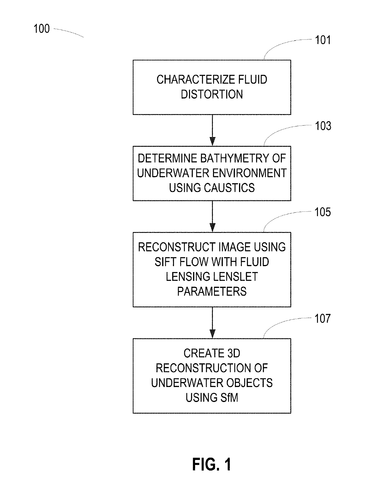
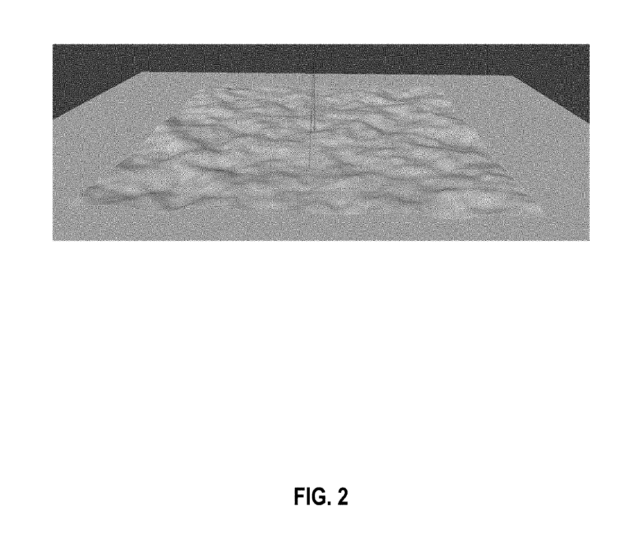
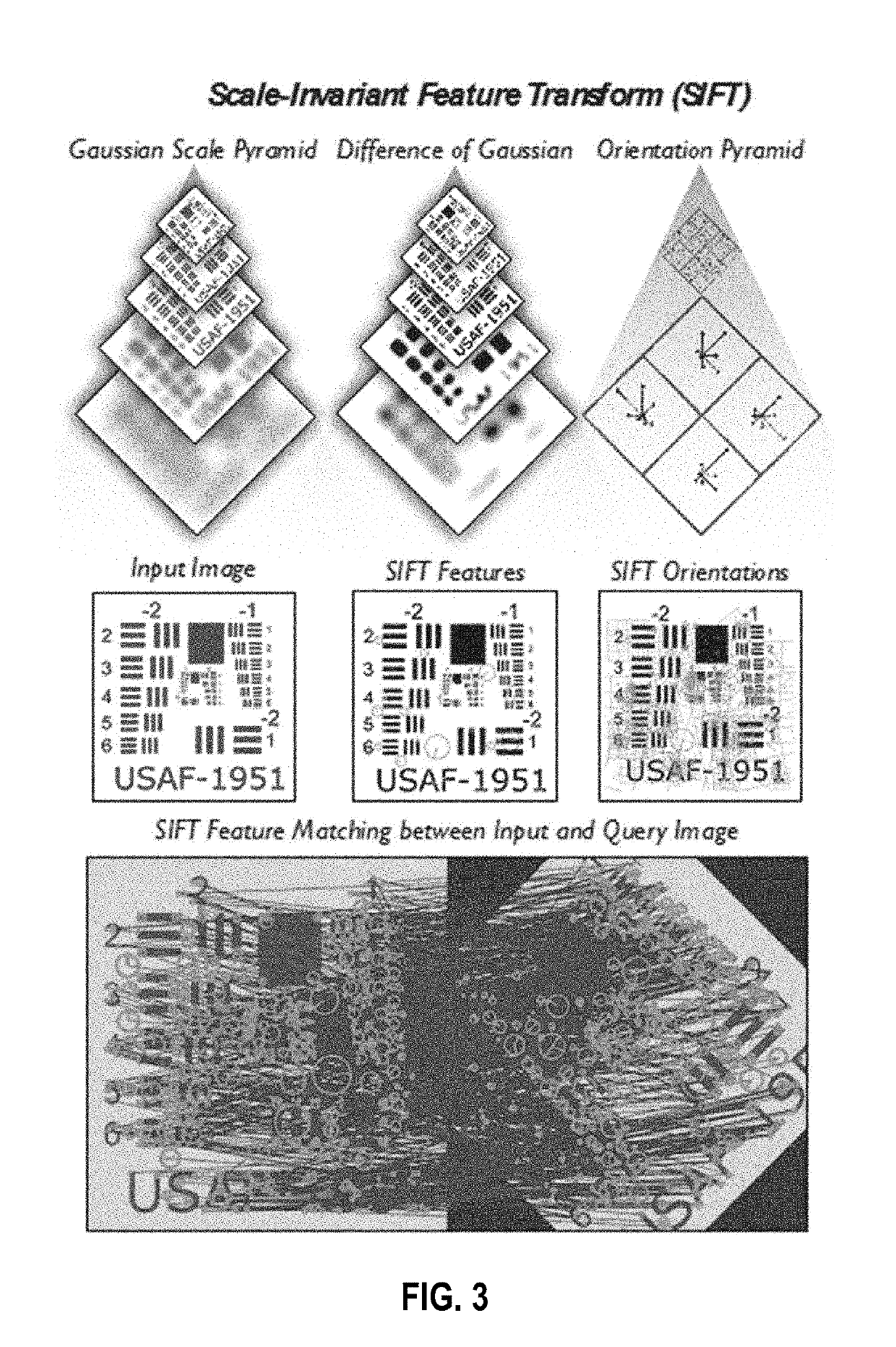
- The development of a high-resolution aquatic remote sensing technique using fluid lensing lenslets and caustic bands to enhance spatial resolution and signal-to-noise properties, employing unmanned aerial vehicles (UAVs) to capture images through ocean waves, and employing a fluid distortion characterization methodology, caustic bathymetry concepts, and a fluid lensing lenslet homography technique for 2D and 3D image reconstruction.

Airborne system and method for characterising and collecting water
PatentWO2024132529A1
Innovation
- An airborne system utilizing an aerial drone equipped with optical sensors, geolocation means, and winches for positioning instrumentation devices at various depths, allowing for real-time data acquisition and sampling while minimizing human intervention and adapting to harsh water conditions.


Water Resource Regulations and Compliance Requirements
The deployment of fixed-wing drones for water resource management operates within a complex regulatory framework that varies significantly across jurisdictions. At the international level, organizations such as the International Civil Aviation Organization (ICAO) establish baseline standards for unmanned aircraft systems, while regional bodies like the European Union Aviation Safety Agency (EASA) and national authorities including the Federal Aviation Administration (FAA) in the United States impose specific operational requirements. These regulations typically address flight altitude restrictions, visual line-of-sight requirements, pilot certification standards, and airspace authorization procedures that directly impact drone-based water monitoring operations.
Water resource management itself is governed by environmental protection agencies and water authorities that mandate specific data quality standards and monitoring protocols. In the United States, the Environmental Protection Agency (EPA) enforces the Clean Water Act, requiring precise documentation of water quality parameters with defined accuracy thresholds. Similarly, the European Water Framework Directive establishes comprehensive monitoring obligations for member states, specifying minimum sampling frequencies and measurement precision levels that drone-collected data must satisfy to be legally admissible for compliance reporting.
Data privacy and security regulations present additional compliance layers, particularly when drone operations involve capturing imagery over private properties or sensitive infrastructure. The General Data Protection Regulation (GDPR) in Europe and various state-level privacy laws in North America impose strict requirements on data collection, storage, and processing. Water management entities must ensure that drone operations incorporate appropriate data anonymization techniques and secure transmission protocols to protect potentially sensitive information about water usage patterns or facility locations.
Emerging regulations specifically targeting drone-based environmental monitoring are beginning to address data capture precision requirements more explicitly. Several jurisdictions now require calibration certificates for drone-mounted sensors, traceability of measurement standards, and validation protocols comparing drone-collected data against traditional ground-truth measurements. These evolving compliance frameworks necessitate that organizations maintain comprehensive documentation of sensor specifications, flight parameters, and data processing methodologies to demonstrate regulatory adherence and ensure the legal defensibility of monitoring results in enforcement or litigation contexts.
Environmental Impact of Drone-Based Water Monitoring
The deployment of fixed-wing drones for water resource monitoring represents a significant advancement in environmental surveillance capabilities, yet it introduces a complex array of environmental considerations that warrant careful examination. While these unmanned aerial systems offer unprecedented data capture precision across vast water bodies, their operational footprint on ecosystems requires systematic assessment to ensure sustainable implementation practices.
Aircraft noise pollution constitutes a primary environmental concern, particularly in ecologically sensitive watersheds and protected aquatic habitats. Fixed-wing drones generate acoustic signatures during flight operations that may disturb wildlife populations, including migratory birds, nesting waterfowl, and terrestrial species inhabiting riparian zones. The frequency and intensity of monitoring missions must be calibrated to minimize behavioral disruption, especially during critical breeding seasons or migration periods when species vulnerability peaks.
Energy consumption patterns associated with drone-based monitoring present both challenges and opportunities for environmental stewardship. Battery-powered fixed-wing platforms require careful lifecycle assessment, encompassing manufacturing impacts, operational energy demands, and end-of-life disposal considerations. However, when compared to traditional manned aircraft or ground-based survey methods, drone operations demonstrate substantially reduced carbon emissions per data point collected, offering a more sustainable alternative for routine water quality assessments.
Physical interaction risks between drones and wildlife, though statistically minimal with fixed-wing configurations operating at higher altitudes, remain relevant in areas with concentrated avian populations. Flight path planning algorithms must incorporate ecological sensitivity mapping to avoid critical habitats and maintain safe separation distances from known wildlife corridors. Seasonal restrictions and altitude adjustments serve as effective mitigation strategies in high-risk zones.
The electromagnetic emissions from drone communication systems and onboard sensors introduce another dimension of environmental impact requiring evaluation. While current evidence suggests minimal biological effects at operational power levels, ongoing monitoring ensures compliance with precautionary principles, particularly in pristine aquatic environments where baseline electromagnetic conditions remain undisturbed. Cumulative effects from increased drone deployment density necessitate longitudinal environmental monitoring to detect any subtle ecosystem responses over time.
Unlock deeper insights with Patsnap Eureka Quick Research — get a full tech report to explore trends and direct your research. Try now!
Generate Your Research Report Instantly with AI Agent
Supercharge your innovation with Patsnap Eureka AI Agent Platform!