

How to Harness Electromagnetic Waves for Remote Sensing?
JUL 11, 20259 MIN READ
Generate Your Research Report Instantly with AI Agent
PatSnap Eureka helps you evaluate technical feasibility & market potential.
EM Wave Remote Sensing Background and Objectives
Electromagnetic wave remote sensing has emerged as a powerful tool for observing and analyzing the Earth's surface and atmosphere from a distance. This technology harnesses the properties of electromagnetic waves to gather information about objects and phenomena without physical contact. The development of remote sensing techniques dates back to the mid-20th century, with significant advancements in recent decades due to technological progress in sensors, data processing, and satellite systems.
The evolution of electromagnetic wave remote sensing has been driven by the increasing demand for accurate and timely information about the Earth's environment, natural resources, and human activities. From early aerial photography to sophisticated satellite-based systems, the field has continuously expanded its capabilities and applications. Today, remote sensing plays a crucial role in various domains, including climate monitoring, disaster management, urban planning, and natural resource exploration.
The primary objective of electromagnetic wave remote sensing is to extract valuable information from the interaction between electromagnetic radiation and the Earth's surface or atmosphere. This involves the detection and measurement of reflected or emitted electromagnetic energy across different wavelengths of the electromagnetic spectrum. By analyzing these signals, researchers and practitioners can infer properties such as surface temperature, vegetation cover, soil moisture, and atmospheric composition.
As technology advances, the goals of remote sensing continue to evolve. Current objectives include improving spatial and temporal resolution, enhancing data accuracy, and developing more sophisticated algorithms for data interpretation. There is also a growing emphasis on integrating remote sensing data with other sources of information, such as in-situ measurements and social media data, to provide more comprehensive and contextual insights.
The future of electromagnetic wave remote sensing is likely to focus on overcoming current limitations and exploring new frontiers. This may involve the development of more sensitive sensors, the use of artificial intelligence for data analysis, and the deployment of novel platforms such as small satellites and high-altitude pseudo-satellites. Additionally, there is a push towards real-time monitoring capabilities and the ability to detect and measure increasingly subtle environmental changes.
In conclusion, the background and objectives of electromagnetic wave remote sensing reflect a dynamic and rapidly evolving field. As technology continues to advance, the potential applications and impact of this technology are expected to grow, offering new opportunities for scientific discovery, environmental management, and societal benefit.
The evolution of electromagnetic wave remote sensing has been driven by the increasing demand for accurate and timely information about the Earth's environment, natural resources, and human activities. From early aerial photography to sophisticated satellite-based systems, the field has continuously expanded its capabilities and applications. Today, remote sensing plays a crucial role in various domains, including climate monitoring, disaster management, urban planning, and natural resource exploration.
The primary objective of electromagnetic wave remote sensing is to extract valuable information from the interaction between electromagnetic radiation and the Earth's surface or atmosphere. This involves the detection and measurement of reflected or emitted electromagnetic energy across different wavelengths of the electromagnetic spectrum. By analyzing these signals, researchers and practitioners can infer properties such as surface temperature, vegetation cover, soil moisture, and atmospheric composition.
As technology advances, the goals of remote sensing continue to evolve. Current objectives include improving spatial and temporal resolution, enhancing data accuracy, and developing more sophisticated algorithms for data interpretation. There is also a growing emphasis on integrating remote sensing data with other sources of information, such as in-situ measurements and social media data, to provide more comprehensive and contextual insights.
The future of electromagnetic wave remote sensing is likely to focus on overcoming current limitations and exploring new frontiers. This may involve the development of more sensitive sensors, the use of artificial intelligence for data analysis, and the deployment of novel platforms such as small satellites and high-altitude pseudo-satellites. Additionally, there is a push towards real-time monitoring capabilities and the ability to detect and measure increasingly subtle environmental changes.
In conclusion, the background and objectives of electromagnetic wave remote sensing reflect a dynamic and rapidly evolving field. As technology continues to advance, the potential applications and impact of this technology are expected to grow, offering new opportunities for scientific discovery, environmental management, and societal benefit.
Market Demand Analysis for EM Wave Remote Sensing
The market demand for electromagnetic (EM) wave remote sensing technologies has been experiencing significant growth across various sectors. This surge is primarily driven by the increasing need for accurate and real-time data collection in fields such as environmental monitoring, agriculture, urban planning, and disaster management.
In the environmental sector, there is a growing demand for EM wave remote sensing to monitor climate change impacts, track deforestation, and assess air and water quality. Governments and environmental agencies are investing heavily in these technologies to support evidence-based policymaking and conservation efforts. The agricultural industry is also embracing EM wave remote sensing for precision farming applications, including crop health monitoring, yield prediction, and soil moisture assessment, leading to improved resource management and increased productivity.
Urban planners and infrastructure developers are increasingly relying on EM wave remote sensing for land use mapping, urban heat island studies, and infrastructure monitoring. This demand is particularly strong in rapidly developing regions where traditional surveying methods struggle to keep pace with urban expansion. In the realm of disaster management, the ability of EM wave remote sensing to provide rapid, large-scale assessments of affected areas has made it an indispensable tool for emergency response and recovery planning.
The defense and security sector represents another significant market for EM wave remote sensing technologies. Applications in this field include border surveillance, maritime monitoring, and intelligence gathering, driving substantial investments in advanced sensor systems and data processing capabilities.
The global market for EM wave remote sensing is expected to continue its upward trajectory, with emerging applications in autonomous vehicles, smart cities, and Internet of Things (IoT) networks further expanding the demand. As the technology becomes more accessible and cost-effective, small and medium-sized enterprises are also entering the market, particularly in the development of specialized sensors and data analytics solutions.
However, the market faces challenges such as data privacy concerns, regulatory hurdles in certain regions, and the need for skilled professionals to interpret complex remote sensing data. Despite these obstacles, the overall trend indicates a robust and growing market for EM wave remote sensing technologies, with innovations in sensor miniaturization, artificial intelligence, and cloud computing expected to unlock new opportunities and drive further market expansion in the coming years.
In the environmental sector, there is a growing demand for EM wave remote sensing to monitor climate change impacts, track deforestation, and assess air and water quality. Governments and environmental agencies are investing heavily in these technologies to support evidence-based policymaking and conservation efforts. The agricultural industry is also embracing EM wave remote sensing for precision farming applications, including crop health monitoring, yield prediction, and soil moisture assessment, leading to improved resource management and increased productivity.
Urban planners and infrastructure developers are increasingly relying on EM wave remote sensing for land use mapping, urban heat island studies, and infrastructure monitoring. This demand is particularly strong in rapidly developing regions where traditional surveying methods struggle to keep pace with urban expansion. In the realm of disaster management, the ability of EM wave remote sensing to provide rapid, large-scale assessments of affected areas has made it an indispensable tool for emergency response and recovery planning.
The defense and security sector represents another significant market for EM wave remote sensing technologies. Applications in this field include border surveillance, maritime monitoring, and intelligence gathering, driving substantial investments in advanced sensor systems and data processing capabilities.
The global market for EM wave remote sensing is expected to continue its upward trajectory, with emerging applications in autonomous vehicles, smart cities, and Internet of Things (IoT) networks further expanding the demand. As the technology becomes more accessible and cost-effective, small and medium-sized enterprises are also entering the market, particularly in the development of specialized sensors and data analytics solutions.
However, the market faces challenges such as data privacy concerns, regulatory hurdles in certain regions, and the need for skilled professionals to interpret complex remote sensing data. Despite these obstacles, the overall trend indicates a robust and growing market for EM wave remote sensing technologies, with innovations in sensor miniaturization, artificial intelligence, and cloud computing expected to unlock new opportunities and drive further market expansion in the coming years.
Current Challenges in EM Wave Remote Sensing
Electromagnetic (EM) wave remote sensing faces several significant challenges that hinder its widespread adoption and effectiveness. One of the primary obstacles is the issue of signal attenuation and interference. As EM waves propagate through the atmosphere, they encounter various obstacles and phenomena that can weaken or distort the signal. Atmospheric absorption, scattering, and refraction can significantly impact the quality and reliability of remote sensing data, particularly in adverse weather conditions or over long distances.
Another major challenge is the complexity of data interpretation and analysis. The vast amount of data collected through EM wave remote sensing requires sophisticated algorithms and processing techniques to extract meaningful information. This process is often time-consuming and computationally intensive, making real-time analysis and decision-making difficult. Additionally, the interpretation of remote sensing data can be subjective and prone to errors, especially when dealing with complex environments or subtle changes in the observed phenomena.
The limited spatial and temporal resolution of current EM wave remote sensing systems also poses a significant challenge. While advancements have been made in sensor technology, there is still a trade-off between coverage area and resolution. High-resolution imagery often comes at the cost of reduced coverage, while wide-area sensing may lack the detail required for certain applications. This limitation affects the ability to detect and monitor small-scale changes or phenomena that occur over short time periods.
Furthermore, the issue of penetration depth remains a challenge for EM wave remote sensing, particularly in applications involving subsurface or underwater sensing. Different EM wave frequencies have varying abilities to penetrate materials, and finding the right balance between penetration depth and resolution is often difficult. This limitation affects applications such as soil moisture monitoring, underground resource exploration, and marine remote sensing.
Lastly, the development and deployment of EM wave remote sensing systems face economic and regulatory challenges. The high costs associated with developing, launching, and maintaining satellite-based systems can be prohibitive for many organizations. Additionally, the use of certain EM wave frequencies for remote sensing is subject to regulatory restrictions and international agreements, which can limit the availability of optimal frequency bands for specific applications.
Addressing these challenges requires ongoing research and innovation in sensor technology, data processing algorithms, and system integration. Advancements in artificial intelligence and machine learning show promise in improving data interpretation and analysis. Similarly, the development of multi-sensor systems and fusion techniques may help overcome some of the limitations in spatial and temporal resolution. As the field of EM wave remote sensing continues to evolve, overcoming these challenges will be crucial for expanding its applications and improving its effectiveness across various domains.
Another major challenge is the complexity of data interpretation and analysis. The vast amount of data collected through EM wave remote sensing requires sophisticated algorithms and processing techniques to extract meaningful information. This process is often time-consuming and computationally intensive, making real-time analysis and decision-making difficult. Additionally, the interpretation of remote sensing data can be subjective and prone to errors, especially when dealing with complex environments or subtle changes in the observed phenomena.
The limited spatial and temporal resolution of current EM wave remote sensing systems also poses a significant challenge. While advancements have been made in sensor technology, there is still a trade-off between coverage area and resolution. High-resolution imagery often comes at the cost of reduced coverage, while wide-area sensing may lack the detail required for certain applications. This limitation affects the ability to detect and monitor small-scale changes or phenomena that occur over short time periods.
Furthermore, the issue of penetration depth remains a challenge for EM wave remote sensing, particularly in applications involving subsurface or underwater sensing. Different EM wave frequencies have varying abilities to penetrate materials, and finding the right balance between penetration depth and resolution is often difficult. This limitation affects applications such as soil moisture monitoring, underground resource exploration, and marine remote sensing.
Lastly, the development and deployment of EM wave remote sensing systems face economic and regulatory challenges. The high costs associated with developing, launching, and maintaining satellite-based systems can be prohibitive for many organizations. Additionally, the use of certain EM wave frequencies for remote sensing is subject to regulatory restrictions and international agreements, which can limit the availability of optimal frequency bands for specific applications.
Addressing these challenges requires ongoing research and innovation in sensor technology, data processing algorithms, and system integration. Advancements in artificial intelligence and machine learning show promise in improving data interpretation and analysis. Similarly, the development of multi-sensor systems and fusion techniques may help overcome some of the limitations in spatial and temporal resolution. As the field of EM wave remote sensing continues to evolve, overcoming these challenges will be crucial for expanding its applications and improving its effectiveness across various domains.
Existing EM Wave Remote Sensing Solutions
01 Electromagnetic wave detection and imaging systems
Advanced systems for detecting and imaging electromagnetic waves in remote sensing applications. These systems utilize various sensors and processing techniques to capture and analyze electromagnetic signals from distant objects or phenomena, enabling high-resolution imaging and data collection for environmental monitoring, security, and scientific research.- Electromagnetic wave detection and imaging systems: Advanced systems for detecting and imaging electromagnetic waves in remote sensing applications. These systems utilize various sensors and processing techniques to capture and analyze electromagnetic signals from distant objects or phenomena, enabling high-resolution imaging and data collection for environmental monitoring, security, and scientific research.
- Remote sensing using multiple wavelengths: Techniques for remote sensing that employ multiple electromagnetic wavelengths to gather comprehensive data about target objects or areas. By utilizing different parts of the electromagnetic spectrum, these methods can provide more detailed and accurate information about surface properties, atmospheric conditions, and other environmental factors.
- Electromagnetic wave-based communication systems: Development of communication systems that use electromagnetic waves for remote sensing and data transmission. These systems enable long-distance communication and data exchange in various applications, including environmental monitoring, disaster management, and space exploration.
- Electromagnetic interference mitigation in remote sensing: Methods and technologies for reducing electromagnetic interference in remote sensing applications. These approaches aim to improve the accuracy and reliability of remote sensing data by minimizing the impact of unwanted electromagnetic signals and noise from various sources.
- Integration of remote sensing with other technologies: Innovative approaches that combine electromagnetic wave-based remote sensing with other technologies such as artificial intelligence, machine learning, and advanced data processing techniques. These integrations enhance the capabilities of remote sensing systems, enabling more efficient data analysis, pattern recognition, and decision-making in various fields.
02 Remote sensing using specific electromagnetic wave bands
Techniques for remote sensing that focus on specific electromagnetic wave bands, such as infrared, microwave, or terahertz. These methods exploit the unique properties of different wave bands to gather information about target objects or areas, allowing for specialized applications in fields like agriculture, geology, and atmospheric science.Expand Specific Solutions03 Signal processing and data analysis for remote sensing
Advanced algorithms and computational methods for processing and analyzing electromagnetic wave data collected through remote sensing. These techniques enhance the quality of collected data, extract meaningful information, and enable the interpretation of complex electromagnetic signatures for various applications.Expand Specific Solutions04 Sensor technologies for electromagnetic wave detection
Innovative sensor technologies designed specifically for detecting and measuring electromagnetic waves in remote sensing applications. These sensors may include advanced materials, novel designs, or improved sensitivity to enhance the accuracy and range of remote sensing capabilities across different electromagnetic spectrum regions.Expand Specific Solutions05 Integration of remote sensing with other technologies
Combining electromagnetic wave remote sensing with other technologies such as GPS, artificial intelligence, or Internet of Things (IoT) to create more comprehensive and efficient monitoring systems. These integrated approaches enhance the capabilities of remote sensing by incorporating additional data sources and advanced analysis techniques.Expand Specific Solutions
Key Players in EM Wave Remote Sensing Industry
The electromagnetic wave remote sensing market is in a growth phase, driven by increasing applications in environmental monitoring, defense, and agriculture. The global market size is projected to expand significantly in the coming years. Technologically, the field is advancing rapidly, with key players like Lockheed Martin, Boeing, and China Academy of Space Technology leading innovation. These companies are developing sophisticated sensors and data processing algorithms to enhance remote sensing capabilities. Universities such as MIT and Zhejiang University are contributing to fundamental research, while government agencies like NASA are pushing the boundaries of space-based remote sensing. The industry is seeing a trend towards miniaturization and integration of multiple sensing technologies, with companies like Canon and Hitachi bringing expertise in optics and electronics to the field.
Lockheed Martin Corp.
Technical Solution: Lockheed Martin has developed advanced electromagnetic wave-based remote sensing technologies for both defense and civilian applications. Their approach includes the use of multi-spectral and hyperspectral imaging systems, as well as advanced radar technologies. For instance, their Advanced Technology Center has worked on compact hyperspectral imagers for small satellites, enabling high-resolution Earth observation[4]. In the radar domain, Lockheed Martin has developed the Space Fence system, which uses S-band radar to detect and track objects in low Earth orbit[5]. They also focus on integrating AI and machine learning with remote sensing data to enhance analysis and decision-making capabilities[6].
Strengths: Strong expertise in defense-related remote sensing applications, advanced integration of AI with sensor data. Weaknesses: Some technologies may be restricted due to defense-related nature, potentially limiting civilian applications.
The Boeing Co.
Technical Solution: Boeing's approach to harnessing electromagnetic waves for remote sensing focuses on both airborne and space-based platforms. They have developed advanced synthetic aperture radar (SAR) systems, such as the P-8A Poseidon's AN/APY-10 radar, which uses electromagnetic waves for maritime surveillance and reconnaissance[7]. In the space domain, Boeing has worked on satellite-based remote sensing technologies, including the development of small satellite constellations for Earth observation. Their digital payloads allow for flexible and reconfigurable electromagnetic wave usage, adapting to various remote sensing needs[8]. Boeing also invests in quantum sensing technologies, which could revolutionize the sensitivity and accuracy of electromagnetic wave-based remote sensing in the future[9].
Strengths: Extensive experience in both airborne and space-based platforms, strong integration capabilities for complex systems. Weaknesses: May face challenges in rapidly evolving commercial space markets compared to more agile startups.
Core Innovations in EM Wave Remote Sensing
Device for reflecting electromagnetic waves, particularly light and heat radiation to a regulable extent, and method for the metalization of a film with a density varying with longitudinal position according to a given function
PatentInactiveUS20050287295A1
Innovation
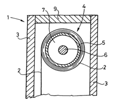
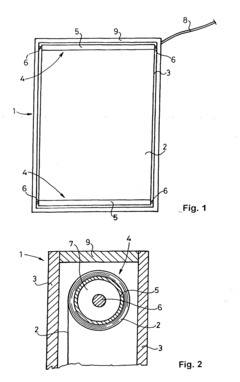
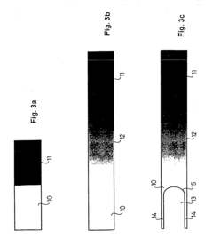
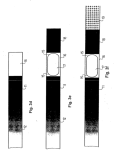
- A device comprising a metallized film between two transparent protective plates with varying metal density along its length, driven by motorized rollers, creating an airtight space for improved heat insulation and automated light control, with integrated sensors and solar-powered control units for efficient operation.
Patent
Innovation
- Novel use of multi-frequency electromagnetic waves for enhanced remote sensing capabilities.
- Development of advanced antenna arrays for more precise directional control of electromagnetic waves in remote sensing applications.
- Implementation of adaptive signal processing techniques to mitigate interference and improve signal-to-noise ratio in electromagnetic wave remote sensing.
Environmental Impact of EM Wave Remote Sensing
The environmental impact of electromagnetic (EM) wave remote sensing is a complex and multifaceted issue that requires careful consideration. While this technology offers significant benefits in various fields, including environmental monitoring, it also poses potential risks to ecosystems and biodiversity.
One of the primary concerns is the potential disruption of wildlife behavior and migration patterns. EM waves used in remote sensing can interfere with the natural electromagnetic fields that some animals use for navigation. For instance, migratory birds and marine species like sea turtles rely on the Earth's magnetic field for orientation during long-distance journeys. The introduction of artificial EM waves may lead to disorientation and altered migration routes, potentially impacting population dynamics and ecosystem balance.
Furthermore, the proliferation of remote sensing satellites and ground-based systems has led to an increase in electromagnetic radiation in the environment. While the levels are generally considered low, there is ongoing research to understand the long-term effects of this exposure on various organisms, including plants, insects, and microorganisms. Some studies suggest that prolonged exposure to certain frequencies of EM waves may affect plant growth, pollination processes, and soil microbial activity.
The construction and operation of remote sensing infrastructure also contribute to environmental concerns. Ground stations and large antenna arrays required for data reception and transmission can lead to habitat fragmentation and loss. The energy consumption of these facilities, particularly in remote areas, may necessitate the development of new power sources, potentially increasing carbon footprints if not managed sustainably.
However, it is crucial to note that EM wave remote sensing also plays a vital role in environmental protection and conservation efforts. Satellite-based remote sensing enables large-scale monitoring of deforestation, ice melt, ocean health, and atmospheric composition. This data is invaluable for climate change research, disaster management, and the development of sustainable resource management strategies.
To mitigate the potential negative impacts, researchers and policymakers are exploring several approaches. These include optimizing the frequency and power of EM waves used in remote sensing to minimize interference with natural systems, developing more energy-efficient technologies, and implementing strict guidelines for the placement and operation of remote sensing infrastructure. Additionally, there is a growing emphasis on integrating remote sensing data with in-situ observations to provide a more comprehensive understanding of environmental changes while reducing the need for excessive EM wave emissions.
As the field of remote sensing continues to evolve, balancing its benefits with environmental protection remains a key challenge. Ongoing research and international cooperation are essential to develop best practices that maximize the utility of EM wave remote sensing while minimizing its ecological footprint.
One of the primary concerns is the potential disruption of wildlife behavior and migration patterns. EM waves used in remote sensing can interfere with the natural electromagnetic fields that some animals use for navigation. For instance, migratory birds and marine species like sea turtles rely on the Earth's magnetic field for orientation during long-distance journeys. The introduction of artificial EM waves may lead to disorientation and altered migration routes, potentially impacting population dynamics and ecosystem balance.
Furthermore, the proliferation of remote sensing satellites and ground-based systems has led to an increase in electromagnetic radiation in the environment. While the levels are generally considered low, there is ongoing research to understand the long-term effects of this exposure on various organisms, including plants, insects, and microorganisms. Some studies suggest that prolonged exposure to certain frequencies of EM waves may affect plant growth, pollination processes, and soil microbial activity.
The construction and operation of remote sensing infrastructure also contribute to environmental concerns. Ground stations and large antenna arrays required for data reception and transmission can lead to habitat fragmentation and loss. The energy consumption of these facilities, particularly in remote areas, may necessitate the development of new power sources, potentially increasing carbon footprints if not managed sustainably.
However, it is crucial to note that EM wave remote sensing also plays a vital role in environmental protection and conservation efforts. Satellite-based remote sensing enables large-scale monitoring of deforestation, ice melt, ocean health, and atmospheric composition. This data is invaluable for climate change research, disaster management, and the development of sustainable resource management strategies.
To mitigate the potential negative impacts, researchers and policymakers are exploring several approaches. These include optimizing the frequency and power of EM waves used in remote sensing to minimize interference with natural systems, developing more energy-efficient technologies, and implementing strict guidelines for the placement and operation of remote sensing infrastructure. Additionally, there is a growing emphasis on integrating remote sensing data with in-situ observations to provide a more comprehensive understanding of environmental changes while reducing the need for excessive EM wave emissions.
As the field of remote sensing continues to evolve, balancing its benefits with environmental protection remains a key challenge. Ongoing research and international cooperation are essential to develop best practices that maximize the utility of EM wave remote sensing while minimizing its ecological footprint.
Data Processing and Analysis in EM Wave Remote Sensing
Data processing and analysis play a crucial role in electromagnetic (EM) wave remote sensing, transforming raw sensor data into meaningful information. The process typically begins with data acquisition, where EM waves reflected or emitted from the target are captured by sensors. These sensors can be mounted on satellites, aircraft, or ground-based platforms, each offering different perspectives and coverage areas.
Once collected, the raw data undergoes preprocessing to remove noise, correct for atmospheric effects, and calibrate the sensors. This step is essential for ensuring data quality and consistency across different acquisition times and conditions. Radiometric and geometric corrections are applied to account for variations in sensor response and distortions caused by the Earth's curvature and terrain.
Feature extraction is the next critical phase, where relevant information is distilled from the preprocessed data. This may involve spectral analysis, texture analysis, or pattern recognition techniques. Advanced algorithms, such as machine learning and artificial intelligence, are increasingly employed to identify and classify features of interest automatically.
Image enhancement techniques are often applied to improve the visual interpretability of the data. These may include contrast stretching, edge detection, or false color compositing to highlight specific features or phenomena. For multispectral or hyperspectral data, band combinations can be optimized to reveal particular characteristics of the target area.
Data fusion is another important aspect of EM wave remote sensing analysis. This involves combining data from multiple sensors or different sensing modalities to create a more comprehensive understanding of the target. For instance, optical imagery might be fused with radar data to leverage the strengths of both technologies.
The final stages of analysis often involve the application of specific models or algorithms tailored to the remote sensing application. This could include change detection algorithms for monitoring environmental changes, inversion models for retrieving physical parameters like soil moisture or vegetation indices, or classification algorithms for land use mapping.
Throughout the data processing and analysis workflow, quality control and validation are essential. This involves comparing results with ground truth data, assessing the accuracy of classifications or parameter retrievals, and quantifying uncertainties in the final products. The outcomes of these analyses are typically presented in the form of thematic maps, time series, or statistical reports, providing valuable insights for decision-makers in fields such as environmental monitoring, urban planning, and disaster management.
Once collected, the raw data undergoes preprocessing to remove noise, correct for atmospheric effects, and calibrate the sensors. This step is essential for ensuring data quality and consistency across different acquisition times and conditions. Radiometric and geometric corrections are applied to account for variations in sensor response and distortions caused by the Earth's curvature and terrain.
Feature extraction is the next critical phase, where relevant information is distilled from the preprocessed data. This may involve spectral analysis, texture analysis, or pattern recognition techniques. Advanced algorithms, such as machine learning and artificial intelligence, are increasingly employed to identify and classify features of interest automatically.
Image enhancement techniques are often applied to improve the visual interpretability of the data. These may include contrast stretching, edge detection, or false color compositing to highlight specific features or phenomena. For multispectral or hyperspectral data, band combinations can be optimized to reveal particular characteristics of the target area.
Data fusion is another important aspect of EM wave remote sensing analysis. This involves combining data from multiple sensors or different sensing modalities to create a more comprehensive understanding of the target. For instance, optical imagery might be fused with radar data to leverage the strengths of both technologies.
The final stages of analysis often involve the application of specific models or algorithms tailored to the remote sensing application. This could include change detection algorithms for monitoring environmental changes, inversion models for retrieving physical parameters like soil moisture or vegetation indices, or classification algorithms for land use mapping.
Throughout the data processing and analysis workflow, quality control and validation are essential. This involves comparing results with ground truth data, assessing the accuracy of classifications or parameter retrievals, and quantifying uncertainties in the final products. The outcomes of these analyses are typically presented in the form of thematic maps, time series, or statistical reports, providing valuable insights for decision-makers in fields such as environmental monitoring, urban planning, and disaster management.
Unlock deeper insights with PatSnap Eureka Quick Research — get a full tech report to explore trends and direct your research. Try now!
Generate Your Research Report Instantly with AI Agent
Supercharge your innovation with PatSnap Eureka AI Agent Platform!