

How to Use Electromagnetic Waves for Remote Sensing
MAR 6, 20269 MIN READ
Generate Your Research Report Instantly with AI Agent
Patsnap Eureka helps you evaluate technical feasibility & market potential.
Electromagnetic Remote Sensing Background and Objectives
Electromagnetic remote sensing represents a revolutionary approach to Earth observation and environmental monitoring that has fundamentally transformed our understanding of planetary systems. This technology leverages the interaction between electromagnetic radiation and matter to acquire information about objects, areas, or phenomena from a distance without making physical contact. The foundation of this field rests on the principle that all objects emit, reflect, and absorb electromagnetic energy in characteristic ways, creating unique spectral signatures that can be detected and analyzed.
The historical development of electromagnetic remote sensing traces back to the early 20th century with the advent of aerial photography, but truly accelerated during the space age of the 1960s. The launch of the first Earth observation satellites marked a paradigm shift from localized ground-based measurements to global-scale monitoring capabilities. This evolution has been driven by advances in sensor technology, satellite platforms, and data processing algorithms, enabling increasingly sophisticated applications across multiple disciplines.
The electromagnetic spectrum utilized in remote sensing spans from radio waves to gamma rays, with different wavelengths offering unique advantages for specific applications. Visible light provides detailed surface features and vegetation health indicators, while infrared radiation reveals thermal properties and moisture content. Microwave frequencies penetrate clouds and vegetation canopies, enabling all-weather monitoring capabilities. This spectral diversity allows for comprehensive characterization of Earth's surface and atmospheric conditions.
Current technological trends indicate a convergence toward hyperspectral imaging, synthetic aperture radar systems, and miniaturized satellite constellations. These developments are expanding temporal resolution capabilities while reducing costs and increasing accessibility. The integration of artificial intelligence and machine learning algorithms is enhancing automated data interpretation and pattern recognition capabilities.
The primary objectives of electromagnetic remote sensing encompass environmental monitoring, natural resource management, climate change assessment, and disaster response coordination. These applications require precise measurement of surface reflectance, temperature variations, atmospheric composition, and topographic changes over time. The technology aims to provide quantitative, repeatable, and standardized observations that support scientific research and operational decision-making processes across global scales.
Market Demand for EM Wave Remote Sensing Applications
The global market for electromagnetic wave remote sensing applications has experienced substantial growth driven by increasing demand across multiple sectors. Earth observation and environmental monitoring represent the largest market segments, with government agencies, research institutions, and commercial entities requiring comprehensive data for climate change studies, natural disaster management, and resource monitoring. The agricultural sector has emerged as a significant growth driver, with precision farming techniques relying heavily on satellite-based remote sensing for crop monitoring, yield prediction, and irrigation management.
Defense and security applications constitute another major market segment, encompassing surveillance, reconnaissance, and border monitoring capabilities. Military organizations worldwide continue to invest heavily in advanced radar systems and satellite constellations for strategic intelligence gathering. The commercial space industry has witnessed remarkable expansion, with private companies launching constellation missions to provide real-time Earth observation services to various industries.
Urban planning and infrastructure development sectors demonstrate growing adoption of remote sensing technologies for smart city initiatives, traffic monitoring, and construction project management. The integration of electromagnetic wave remote sensing with Geographic Information Systems has created new market opportunities in location-based services and spatial analytics.
The maritime industry increasingly relies on remote sensing for vessel tracking, ocean monitoring, and offshore resource exploration. Weather forecasting and meteorological services represent established markets with consistent demand for advanced radar and satellite-based atmospheric monitoring systems. Emergency response and disaster management agencies require real-time remote sensing capabilities for flood monitoring, wildfire detection, and post-disaster assessment.
Market growth is further accelerated by technological advancements in miniaturization, cost reduction of satellite components, and improved data processing capabilities. The emergence of small satellite constellations has democratized access to remote sensing data, creating opportunities for new market entrants and innovative applications across industries previously unable to afford traditional satellite services.
Current State and Challenges of EM Remote Sensing Tech
Electromagnetic remote sensing technology has achieved remarkable maturity across multiple spectral domains, with operational systems spanning from radio frequencies to visible light wavelengths. Current satellite constellations provide comprehensive Earth observation capabilities through synthetic aperture radar (SAR), multispectral and hyperspectral imaging, and passive microwave radiometry. Advanced platforms like Sentinel-1, ALOS-2, and commercial SAR satellites deliver sub-meter resolution imagery with regular revisit cycles, enabling near real-time monitoring of global phenomena.
The technology landscape encompasses diverse sensing modalities, each optimized for specific applications. Active radar systems excel in all-weather monitoring and surface deformation measurements, while optical sensors provide detailed spectral analysis for vegetation and mineral mapping. Passive microwave systems offer unique capabilities for soil moisture and sea surface temperature monitoring, complementing the active sensing portfolio.
Despite technological advances, significant challenges persist in electromagnetic remote sensing implementation. Atmospheric interference remains a fundamental limitation, particularly affecting shorter wavelength systems during adverse weather conditions. Signal attenuation, scattering, and absorption by atmospheric constituents introduce measurement uncertainties that require sophisticated correction algorithms and calibration procedures.
Data processing and interpretation present substantial computational challenges as sensor resolution and coverage expand exponentially. The volume of collected data often exceeds processing capabilities, creating bottlenecks in information extraction and analysis workflows. Machine learning and artificial intelligence integration, while promising, requires extensive training datasets and validation procedures that strain existing infrastructure.
Technological constraints include power limitations for space-based platforms, restricting transmission power and operational duration. Antenna size limitations impose fundamental trade-offs between spatial resolution, swath width, and signal-to-noise ratios. These physical constraints particularly affect small satellite platforms that prioritize cost-effectiveness over performance optimization.
Calibration and validation represent ongoing challenges, especially for quantitative applications requiring high measurement accuracy. Cross-sensor calibration, temporal stability maintenance, and ground truth validation demand continuous effort and substantial resources. International coordination for calibration standards remains inconsistent across different sensor types and operational agencies.
Emerging applications in climate monitoring, disaster response, and precision agriculture demand enhanced temporal resolution and measurement precision beyond current capabilities. The integration of multiple sensing modalities for comprehensive environmental monitoring requires advanced data fusion techniques and standardized processing frameworks that are still under development.
Current EM Wave Remote Sensing Solutions
01 Electromagnetic wave generation and transmission devices
Technologies for generating and transmitting electromagnetic waves across various frequency ranges. These devices include antennas, waveguides, and transmission systems designed to efficiently propagate electromagnetic radiation for communication, radar, and other applications. The systems may incorporate specific geometries and materials to optimize wave propagation characteristics and minimize signal loss.- Electromagnetic wave generation and transmission devices: Technologies for generating and transmitting electromagnetic waves across various frequency ranges. These systems include components such as oscillators, amplifiers, and antenna structures designed to produce and propagate electromagnetic radiation efficiently. The devices can be configured for different applications including communication, radar, and broadcasting systems with specific frequency characteristics and power outputs.
- Electromagnetic wave shielding and absorption materials: Materials and compositions designed to block, absorb, or attenuate electromagnetic waves to prevent interference or protect sensitive equipment. These solutions include conductive materials, composite structures, and specialized coatings that can effectively reduce electromagnetic radiation transmission. The shielding materials can be applied in various forms including films, fabrics, and structural components for different frequency ranges.
- Electromagnetic wave detection and measurement systems: Devices and methods for detecting, measuring, and analyzing electromagnetic waves across different frequency spectrums. These systems incorporate sensors, receivers, and signal processing components to identify and characterize electromagnetic radiation. Applications include spectrum analysis, field strength measurement, and electromagnetic compatibility testing with various sensitivity levels and frequency coverage.
- Electromagnetic wave communication and signal processing: Technologies for utilizing electromagnetic waves in communication systems including modulation, demodulation, and signal processing techniques. These methods enable data transmission through electromagnetic radiation with improved efficiency, bandwidth utilization, and signal quality. The systems can incorporate multiple antenna configurations, beamforming, and advanced coding schemes for enhanced communication performance.
- Electromagnetic wave focusing and beam control: Methods and apparatus for controlling the direction, focus, and shape of electromagnetic wave beams. These technologies include lens systems, reflectors, phased arrays, and metamaterials that can manipulate electromagnetic radiation patterns. Applications range from targeted energy delivery to precision imaging and directed communication with adjustable beam characteristics and spatial control.
02 Electromagnetic wave shielding and absorption materials
Materials and structures designed to block, absorb, or attenuate electromagnetic waves for protection and interference reduction purposes. These solutions include composite materials, conductive coatings, and multilayer structures that can effectively shield against electromagnetic radiation across different frequency bands. Applications range from electronic device protection to building materials for electromagnetic compatibility.Expand Specific Solutions03 Electromagnetic wave detection and measurement systems
Systems and methods for detecting, measuring, and analyzing electromagnetic waves. These technologies include sensors, receivers, and analytical instruments capable of identifying electromagnetic radiation characteristics such as frequency, amplitude, and polarization. The systems may be used for spectrum monitoring, signal analysis, and electromagnetic field measurement in various environments.Expand Specific Solutions04 Electromagnetic wave modulation and signal processing
Techniques for modulating electromagnetic waves and processing electromagnetic signals for data transmission and communication. These methods include various modulation schemes, signal encoding, and decoding technologies that enable efficient information transfer through electromagnetic radiation. The technologies may incorporate digital signal processing, filtering, and error correction mechanisms to improve signal quality and transmission reliability.Expand Specific Solutions05 Electromagnetic wave focusing and beam steering technologies
Systems for controlling the direction and focus of electromagnetic waves through beam forming and steering mechanisms. These technologies utilize phased arrays, metamaterials, or mechanical positioning systems to direct electromagnetic radiation toward specific targets or areas. Applications include radar systems, wireless power transfer, and directed communication links where precise control of electromagnetic wave propagation is required.Expand Specific Solutions
Major Players in EM Remote Sensing Industry
The electromagnetic wave remote sensing technology landscape is in a mature growth phase, characterized by substantial market expansion driven by increasing demand for Earth observation, defense applications, and environmental monitoring. The market demonstrates significant scale with established aerospace giants like Lockheed Martin Corp., The Boeing Co., and NASA leading technological advancement through sophisticated satellite systems and sensor technologies. Technology maturity varies across segments, with established players like Canon Inc., Sony Group Corp., and Hitachi Ltd. contributing advanced imaging and sensor components, while specialized firms such as RADI and China Academy of Space Technology focus on dedicated remote sensing applications. Academic institutions including Zhejiang University, Wuhan University, and University of Florida drive fundamental research innovation. The competitive landscape shows strong consolidation among major defense contractors, while emerging companies like Shenzhen Estone Technology and GUANGZHOU LANGO ELECTRONICS represent growing commercial applications in IoT and smart device integration.
Lockheed Martin Corp.
Technical Solution: Lockheed Martin develops advanced electromagnetic remote sensing systems primarily for defense and aerospace applications. Their technology portfolio includes synthetic aperture radar systems, electronic intelligence gathering platforms, and multi-spectral imaging sensors. The company's approach focuses on high-resolution radar imaging using X-band and L-band frequencies for surveillance and reconnaissance missions. Their systems integrate advanced beamforming techniques and digital signal processing for enhanced target detection and classification capabilities in challenging environments.
Strengths: Strong defense industry expertise, robust system integration capabilities, proven reliability in harsh environments. Weaknesses: Limited civilian market presence, high system costs, restricted technology transfer due to security classifications.
The Boeing Co.
Technical Solution: Boeing implements electromagnetic wave remote sensing through their satellite constellation programs and airborne surveillance systems. Their technology emphasizes phased array radar systems and electro-optical sensors for both commercial and military applications. Boeing's remote sensing solutions incorporate advanced antenna design with electronic beam steering capabilities, enabling rapid area coverage and target tracking. The company develops integrated sensor suites that combine radar, infrared, and visible spectrum sensors for comprehensive situational awareness and environmental monitoring applications.
Strengths: Extensive aerospace integration experience, scalable platform solutions, strong commercial and military market presence. Weaknesses: High development complexity, significant power requirements, limited specialization in pure remote sensing compared to core aerospace business.
Core Technologies in EM Wave Remote Sensing
Electromagnetic wave processing system
PatentPendingEP4535024A1
Innovation
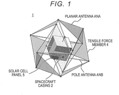
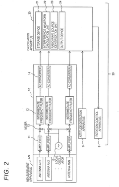
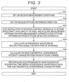
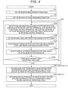
- An electromagnetic wave processing system that includes a plurality of antennas, a measurement apparatus, an attitude detection apparatus, a rotation control apparatus, and a calculation apparatus. The system rotates the spacecraft around its center of gravity on multiple rotational axes, allowing measurements to be taken at various attitudes, and calculates the intensity distribution of electromagnetic waves using interference waveforms from different antennas.
System and method employing single line guided surface electromagnetic (EM) waves for wireless sensing
PatentPendingUS20250052696A1
Innovation
- The use of single line guided surface electromagnetic (EM) waves, known as Goubau waves, propagated along a metallic conductor to interrogate remote wireless sensors, enabling longer-distance communication and secure data transfer.


Spectrum Allocation and Regulatory Framework
The electromagnetic spectrum serves as a finite and valuable resource that requires careful management for remote sensing applications. International coordination through the International Telecommunication Union (ITU) establishes the foundation for spectrum allocation, dividing frequencies into specific bands designated for Earth exploration satellite services, meteorological applications, and scientific research. These allocations ensure that remote sensing systems operate without harmful interference while maintaining compatibility with other radio services.
Primary spectrum allocations for remote sensing span multiple frequency ranges, each offering distinct advantages for different applications. The L-band (1-2 GHz) provides excellent penetration capabilities for soil moisture and vegetation studies, while C-band (4-8 GHz) offers balanced performance for weather monitoring and surface analysis. X-band (8-12 GHz) enables high-resolution imaging applications, and Ku-band (12-18 GHz) supports advanced precipitation measurement systems. Higher frequency allocations in Ka-band and beyond facilitate specialized atmospheric research and cloud profiling missions.
Regulatory frameworks vary significantly across different jurisdictions, creating complex compliance requirements for global remote sensing operations. The Federal Communications Commission (FCC) in the United States, the European Communications Committee (ECC), and national regulatory authorities worldwide establish specific licensing procedures, technical standards, and operational constraints. These regulations address power limitations, spurious emission requirements, coordination procedures with other spectrum users, and data sharing obligations for publicly funded missions.
International coordination mechanisms play a crucial role in managing cross-border interference and ensuring global interoperability. The World Radiocommunication Conference (WRC) periodically reviews and updates spectrum allocations based on evolving technology needs and interference studies. Regional coordination agreements facilitate spectrum sharing between neighboring countries, while bilateral agreements address specific interference scenarios and operational procedures for satellite systems with overlapping coverage areas.
Emerging challenges in spectrum management include the growing demand for commercial remote sensing services, increased deployment of small satellite constellations, and potential conflicts with 5G and other terrestrial wireless services. Regulatory authorities are developing new frameworks to accommodate these trends while maintaining protection for essential Earth observation missions. Dynamic spectrum access techniques and cognitive radio technologies represent potential solutions for more efficient spectrum utilization in future remote sensing systems.
Environmental Impact of EM Remote Sensing Systems
Electromagnetic remote sensing systems, while providing invaluable environmental monitoring capabilities, present several environmental considerations that require careful evaluation. The deployment and operation of these systems generate both direct and indirect environmental impacts across multiple domains, from energy consumption to electromagnetic interference with natural ecosystems.
The primary environmental concern stems from the energy requirements of active remote sensing systems, particularly synthetic aperture radar (SAR) and scatterometer platforms. These systems consume substantial electrical power for signal transmission and data processing, contributing to carbon emissions when powered by conventional energy sources. Satellite-based systems require additional energy for orbital maintenance and thermal regulation, while ground-based installations demand continuous power supply for 24/7 operations.
Electromagnetic interference represents another significant environmental impact, potentially affecting wildlife behavior and migration patterns. Research indicates that certain frequency bands used in remote sensing may interfere with natural electromagnetic navigation systems employed by migratory birds, marine mammals, and insects. The cumulative effect of multiple sensing systems operating simultaneously could create electromagnetic pollution in sensitive ecological areas.
Space-based remote sensing platforms contribute to the growing problem of orbital debris and space pollution. End-of-life satellites and associated hardware components pose long-term environmental risks in Earth's orbital environment. Additionally, rocket launches required for satellite deployment generate atmospheric emissions and contribute to stratospheric ozone depletion through combustion byproducts.
Ground infrastructure development for remote sensing networks often requires land use changes and habitat modification. Installation of ground stations, calibration targets, and communication facilities can fragment natural habitats and alter local ecosystems. Construction activities associated with these installations may disturb soil composition and local hydrology patterns.
However, the environmental benefits of electromagnetic remote sensing systems significantly outweigh their negative impacts. These systems enable comprehensive environmental monitoring, climate change assessment, and natural disaster early warning capabilities that support global environmental protection efforts. The technology facilitates precision agriculture, reducing pesticide and fertilizer usage, and enables efficient natural resource management through accurate mapping and monitoring capabilities.
Unlock deeper insights with Patsnap Eureka Quick Research — get a full tech report to explore trends and direct your research. Try now!
Generate Your Research Report Instantly with AI Agent
Supercharge your innovation with Patsnap Eureka AI Agent Platform!