
Surface settlement observation method based on tilt photography measurement of drone
A technology of oblique photogrammetry and surface subsidence, which is applied in the field of geographic surveying and mapping, can solve the problems of inability to monitor the overall subsidence of the surface, and the inability to guarantee efficiency and safety, and achieve the effects of low observation cost, fast observation speed, and high efficiency
Patent Information
- Authority / Receiving Office
- CN · China
- Current Assignee / Owner
- Publication Date
- 2019-11-15
- Estimated Expiration
- Not applicable · inactive patent
Smart Images
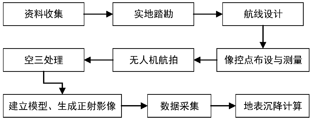
Figure 1 
Figure 2 
Figure 3
Abstract
Description
technical field
[0001] The invention relates to the technical field of geographic surveying and mapping, in particular to a settlement observation method. Background technique
[0002] With the development and maturity of UAV aerial survey and mapping technology, the traditional low-efficiency manual mapping operation method has been gradually replaced. The emergence of UAV photogrammetry technology has greatly improved the measurement accuracy under the premise of ensuring the measurement accuracy. efficiency and safety. Compared with traditional photogrammetry, the accuracy of oblique photogrammetry is greatly improved, and the generated real-world 3D model can intuitively display the actual situation of the measurement area.
[0003] The traditional subsidence observation method is to manually lay out the observation line on the main section of the surface mobile basin, and then conduct traditional measurement on the observation line regularly, and process the observatio...
Examples
Embodiment Construction
[0022] The following will clearly and completely describe the technical solutions in the embodiments of the present invention with reference to the accompanying drawings in the embodiments of the present invention. Obviously, the described embodiments are only some, not all, embodiments of the present invention. Based on the embodiments of the present invention, all other embodiments obtained by persons of ordinary skill in the art without making creative efforts belong to the protection scope of the present invention.
[0023] refer to figure 1 , the present invention provides a surface subsidence observation method based on unmanned aerial vehicle oblique photogrammetry. The present invention uses oblique photogrammetry technology to obtain images of various angles of the subsidence surface, and establishes a subsidence area with spatial information through aerial triangulation and image control point measurement. Real-scene 3D model and orthophoto, use the real-scene 3D mod...