
A real-time slicing and updating method for vector tiles based on multi-layer cache
An update method, vector technology, applied in database update, instrument, geographic information database, etc., can solve the problems of low update efficiency of vector tiles, impossibility of immediate release, complex operation, etc., achieve real-time slicing and update, and improve release efficiency , the effect of reducing workload
Patent Information
- Authority / Receiving Office
- CN · China
- Patent Type
- Patents(China)
- Current Assignee / Owner
- Publication Date
- 2022-04-15
Smart Images
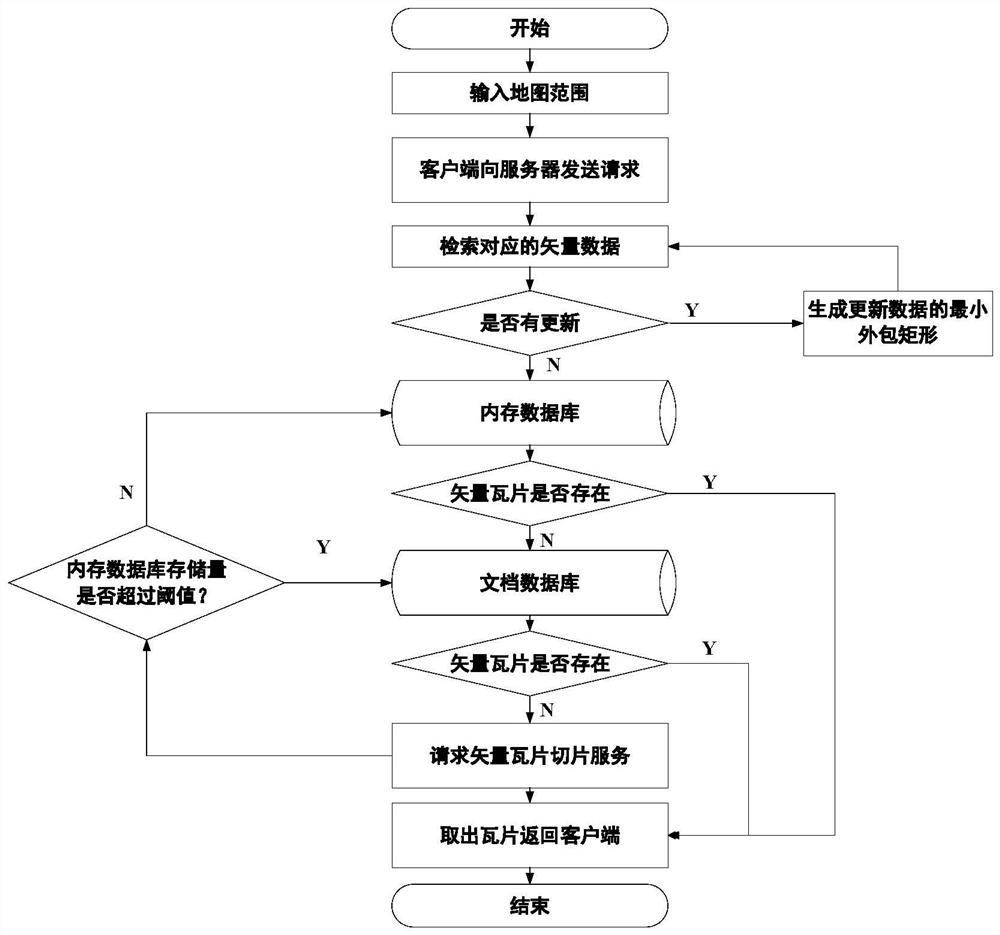
Figure 1 
Figure 2 
Figure 3
Abstract
Description
technical field
[0001] The invention relates to the technical field of digital maps, in particular to a method for real-time slicing and updating of vector tiles based on multi-layer cache. Background technique
[0002] With the geometric progression of spatial measured data, and in the case of limited network bandwidth, it is a common practice for mainstream WebGIS platforms to use tile technology to realize online release of spatial data. This method is to pre-cut the remote sensing image and map vector data into fixed-size tiles by pre-slicing the image slice and vector slice. When the data is loaded, only the visible area is displayed by calculating the current browser view range The tiles in the domain range can greatly reduce the amount of data loading and improve the display efficiency of spatial data. However, in the existing technology, the tile efficiency of spatial data is greatly affected by the amount of data. When the amount of data reaches terabytes, the proc...
Examples
Embodiment Construction
[0038] The specific implementation manner and working principle of the present invention will be further described in detail below in conjunction with the accompanying drawings.
[0039] A specific embodiment of the present invention uses GeoServer as the vector tile service publishing platform, based on the memory database Redis and the non-relational database MongoDB, establishes a multi-layer cache mechanism to store and update vector tiles, and develops the vector tile Partially updated front-end and back-end prototype systems, developed a Web client based on the OpenLayers framework method, and verified the feasibility of the method and technical process proposed by the present invention.
[0040] like figure 1 As shown, a method for real-time slicing and updating of vector tiles based on multi-layer cache, the specific steps are as follows:
[0041] S1. Retrieve in the spatial database according to the input map range, determine whether data update is involved, and retu...