

Electromagnetic Induction for Geological Mapping: Utilization
FEB 25, 20269 MIN READ
Generate Your Research Report Instantly with AI Agent
Patsnap Eureka helps you evaluate technical feasibility & market potential.
EM Induction Geological Mapping Background and Objectives
Electromagnetic induction for geological mapping represents a fundamental geophysical exploration technique that has evolved significantly since its inception in the early 20th century. The method exploits the principle of electromagnetic field propagation through subsurface materials, where variations in electrical conductivity and magnetic permeability create detectable anomalies that correspond to different geological structures and mineral compositions.
The historical development of electromagnetic induction techniques began with early airborne surveys in the 1940s, primarily focused on mineral exploration. Over subsequent decades, technological advances in instrumentation, data processing capabilities, and theoretical understanding have transformed this field into a sophisticated exploration tool capable of addressing diverse geological challenges ranging from groundwater mapping to environmental contamination assessment.
Current technological evolution trends indicate a strong movement toward multi-frequency systems, enhanced signal processing algorithms, and integration with complementary geophysical methods. The advent of unmanned aerial vehicles and satellite-based platforms has further expanded the operational scope and cost-effectiveness of electromagnetic surveys, enabling large-scale regional mapping projects previously considered economically unfeasible.
The primary technical objectives driving contemporary electromagnetic induction research focus on improving spatial resolution, penetration depth, and data interpretation accuracy. Advanced signal processing techniques, including machine learning algorithms and artificial intelligence applications, are being developed to enhance automatic anomaly detection and geological feature classification capabilities.
Integration objectives emphasize the development of comprehensive multi-parameter inversion algorithms that can simultaneously process electromagnetic data alongside gravity, magnetic, and seismic information. This holistic approach aims to reduce interpretation ambiguity and provide more reliable subsurface models for geological decision-making processes.
Environmental and resource exploration applications continue to drive innovation in portable, high-resolution electromagnetic systems capable of detecting subtle conductivity variations associated with groundwater aquifers, contamination plumes, and mineral deposits. The increasing demand for sustainable resource management and environmental monitoring has established electromagnetic induction as an essential tool for modern geological investigation programs.
Market Demand for Advanced Geological Survey Technologies
The global geological survey industry is experiencing unprecedented growth driven by increasing demands across multiple sectors. Mining companies require sophisticated subsurface mapping technologies to identify mineral deposits with greater precision and efficiency, reducing exploration costs and environmental impact. The renewable energy sector, particularly geothermal energy development, relies heavily on advanced geological surveying to locate optimal drilling sites and assess underground thermal resources.
Infrastructure development projects worldwide necessitate comprehensive geological assessments before construction begins. Urban expansion, transportation networks, and large-scale industrial facilities require detailed understanding of subsurface conditions to ensure structural integrity and safety. Traditional geological survey methods often prove insufficient for these complex requirements, creating substantial market demand for more advanced technologies.
Environmental monitoring and groundwater management represent rapidly expanding market segments. Climate change concerns and water scarcity issues drive the need for precise aquifer mapping and contamination detection. Electromagnetic induction technologies offer superior capabilities for identifying subsurface water resources and monitoring environmental changes over time, addressing critical societal needs.
The oil and gas industry continues to seek enhanced exploration technologies despite market fluctuations. Advanced geological survey methods enable more accurate reservoir characterization and reduce dry hole risks, providing significant economic value. Additionally, carbon sequestration projects require detailed geological mapping to identify suitable storage sites, creating new market opportunities.
Archaeological and cultural heritage preservation projects increasingly utilize non-invasive geological survey technologies. These applications require minimal surface disturbance while providing detailed subsurface information, making electromagnetic induction particularly valuable for sensitive historical sites.
Government agencies and research institutions represent stable market segments with consistent funding for geological research and hazard assessment programs. Natural disaster preparedness, including earthquake and landslide risk evaluation, requires continuous geological monitoring and mapping capabilities.
The market demonstrates strong growth potential across developed and emerging economies. Developing nations with significant natural resources seek advanced exploration technologies to maximize economic benefits from their geological assets. Simultaneously, developed countries focus on environmental protection and sustainable resource management, driving demand for precise, non-invasive survey technologies.
Technological integration trends further expand market opportunities. The combination of electromagnetic induction with satellite imagery, artificial intelligence, and real-time data processing creates comprehensive geological intelligence systems that serve multiple industry needs simultaneously.
Current State of EM Induction in Geological Applications
Electromagnetic induction methods have established themselves as fundamental tools in modern geological exploration, with applications spanning mineral prospecting, groundwater mapping, environmental assessment, and geotechnical investigations. The technology leverages the principle of electromagnetic field propagation through subsurface materials, where variations in electrical conductivity and magnetic permeability create detectable anomalies that reveal geological structures and compositions.
Current electromagnetic induction systems operate across multiple frequency domains, ranging from very low frequency (VLF) systems at 15-25 kHz to time-domain electromagnetic (TEM) systems capable of investigating depths exceeding 1000 meters. Frequency-domain electromagnetic (FDEM) instruments dominate shallow subsurface investigations, typically penetrating 10-100 meters depending on ground conductivity and operating frequency. These systems have achieved remarkable sensitivity levels, with modern instruments capable of detecting conductivity variations as small as 0.1 mS/m.
Airborne electromagnetic surveys represent the most advanced deployment platform, utilizing helicopter-mounted or fixed-wing aircraft systems to cover extensive areas rapidly. Leading airborne systems such as VTEM, SkyTEM, and AeroTEM can acquire data at line spacings of 50-200 meters while maintaining survey speeds of 60-120 km/h. These platforms integrate GPS navigation, high-resolution magnetometers, and sophisticated data acquisition systems to ensure precise positioning and data quality.
Ground-based electromagnetic systems continue to evolve with enhanced portability and measurement precision. Multi-coil configurations enable simultaneous depth sounding and lateral mapping, while advanced signal processing algorithms improve noise rejection and data interpretation capabilities. Recent developments include lightweight portable systems weighing less than 15 kg that maintain measurement accuracy comparable to traditional heavy equipment.
Marine electromagnetic applications have expanded significantly, particularly in offshore hydrocarbon exploration and submarine groundwater discharge studies. Controlled-source electromagnetic (CSEM) methods can distinguish hydrocarbon-bearing formations from water-saturated sediments at depths exceeding 3000 meters below the seafloor. Ocean-bottom electromagnetic receivers now achieve deployment durations of several months with autonomous data logging capabilities.
Integration with complementary geophysical methods has become standard practice, combining electromagnetic data with gravity, magnetic, and seismic measurements to reduce interpretation ambiguity. Advanced inversion algorithms incorporate multiple datasets simultaneously, producing more reliable subsurface models than single-method approaches. Machine learning techniques are increasingly applied to pattern recognition and automated anomaly detection in large electromagnetic datasets.
Despite technological advances, several challenges persist in electromagnetic geological applications. Cultural noise from power lines, pipelines, and urban infrastructure continues to limit survey effectiveness in developed areas. Terrain accessibility remains problematic for ground-based surveys in mountainous or heavily vegetated regions. Additionally, the inherent non-uniqueness of electromagnetic inverse problems requires careful integration of geological constraints and prior information to achieve reliable interpretations.
Existing EM Induction Solutions for Subsurface Mapping
01 Electromagnetic induction heating systems and apparatus
Technologies related to electromagnetic induction heating systems utilize alternating magnetic fields to generate heat in conductive materials. These systems typically include induction coils, power supply circuits, and control mechanisms to regulate heating parameters. Applications include industrial heating processes, cooking appliances, and material processing where precise temperature control and energy efficiency are required.- Electromagnetic induction heating systems and apparatus: Technologies related to electromagnetic induction heating systems utilize alternating magnetic fields to generate heat in conductive materials. These systems typically include induction coils, power supply units, and control circuits to regulate heating parameters. Applications include industrial heating processes, cooking appliances, and material processing where precise temperature control and energy efficiency are required.
- Wireless power transfer using electromagnetic induction: Wireless power transfer systems employ electromagnetic induction principles to transmit electrical energy without physical connections. These systems consist of transmitting and receiving coils that operate at specific frequencies to achieve efficient energy transfer. The technology is applied in charging devices, electric vehicles, and portable electronics, providing convenience and eliminating the need for cables.
- Electromagnetic induction sensors and detection devices: Induction-based sensing technologies utilize changes in electromagnetic fields to detect position, proximity, or material properties. These sensors incorporate coil arrangements and signal processing circuits to measure variations in inductance or magnetic coupling. Applications include position sensing, metal detection, non-destructive testing, and automotive systems where reliable and contactless detection is essential.
- Electromagnetic induction motors and actuators: Electromagnetic induction principles are fundamental to the operation of motors and actuators that convert electrical energy into mechanical motion. These devices utilize rotating or linear magnetic fields interacting with conductive elements to produce torque or linear force. The technology is widely used in industrial automation, transportation systems, and precision positioning applications requiring high efficiency and controllability.
- Electromagnetic shielding and interference management: Technologies for managing electromagnetic induction effects focus on shielding sensitive components and reducing unwanted interference. These solutions include conductive barriers, magnetic shielding materials, and circuit design techniques to minimize coupling between electromagnetic sources and susceptible devices. Applications span electronic equipment design, medical devices, and communication systems where electromagnetic compatibility is critical.
02 Wireless power transfer using electromagnetic induction
Wireless power transfer systems employ electromagnetic induction principles to transmit electrical energy without physical connections. These systems consist of transmitting and receiving coils that operate at specific frequencies to achieve efficient energy transfer. The technology is applied in charging devices, electric vehicles, and portable electronics, providing convenience and eliminating the need for cables.Expand Specific Solutions03 Electromagnetic induction sensors and detection devices
Induction-based sensing technologies utilize changes in electromagnetic fields to detect position, proximity, or material properties. These sensors incorporate coil arrangements and signal processing circuits to identify variations in inductance caused by nearby objects or environmental changes. Applications include position sensing, metal detection, and non-contact measurement systems in industrial and automotive contexts.Expand Specific Solutions04 Electromagnetic shielding and interference management
Technologies for managing electromagnetic interference involve shielding structures and materials that control electromagnetic field propagation. These solutions include conductive enclosures, filtering circuits, and layout designs that minimize unwanted induction effects. Such technologies are critical in electronic devices, communication systems, and sensitive equipment where electromagnetic compatibility must be maintained.Expand Specific Solutions05 Electromagnetic induction in motor and generator systems
Motor and generator technologies based on electromagnetic induction convert between electrical and mechanical energy through rotating magnetic fields and conductor arrangements. These systems include stator and rotor configurations, winding designs, and control electronics that optimize performance and efficiency. Applications span electric motors, generators, and electromechanical actuators used in various industrial and transportation applications.Expand Specific Solutions
Key Players in EM Geological Survey Equipment Industry
The electromagnetic induction technology for geological mapping represents a mature and established sector within the geophysical exploration industry, currently valued at several billion dollars globally. The market demonstrates strong consolidation among major oilfield service providers, with Schlumberger Technologies, Baker Hughes Co., and ExxonMobil Upstream Research Co. dominating through comprehensive electromagnetic survey capabilities and advanced data processing systems. Traditional energy giants like Saudi Arabian Oil Co. and Shell Oil Co. drive significant demand as end-users, while specialized firms such as PGS Geophysical AS and Fleet Space Technologies bring innovative approaches including satellite-based solutions. The technology has reached commercial maturity with proven applications in hydrocarbon exploration, mineral detection, and subsurface characterization, though emerging players like KoBold Metals Co. are introducing AI-enhanced interpretation methods that signal ongoing technological evolution within this established market.
Schlumberger Technologies, Inc.
Technical Solution: Schlumberger has developed advanced electromagnetic induction logging tools for subsurface geological mapping, including multi-frequency and multi-spacing electromagnetic sensors that operate at frequencies ranging from 400 Hz to 2 MHz. Their technology utilizes transmitter-receiver coil arrays to measure formation conductivity and resistivity at multiple depths of investigation, enabling detailed characterization of geological layers, fluid content, and rock properties. The system incorporates real-time data processing algorithms and advanced inversion techniques to convert electromagnetic measurements into high-resolution geological maps and formation evaluation parameters.
Strengths: Industry-leading technology with extensive field validation, comprehensive multi-frequency capabilities, and robust real-time processing. Weaknesses: High cost of equipment and services, complex operation requiring specialized expertise.
Baker Hughes Co.
Technical Solution: Baker Hughes employs electromagnetic induction technology through their logging-while-drilling (LWD) and wireline tools for geological formation evaluation. Their electromagnetic systems utilize multiple transmitter-receiver configurations operating at frequencies from 400 Hz to 2 MHz to measure formation resistivity and conductivity. The technology enables real-time geological mapping during drilling operations, providing critical information about formation boundaries, fluid contacts, and rock properties. Their advanced processing algorithms convert electromagnetic responses into detailed subsurface geological models for reservoir characterization and drilling optimization.
Strengths: Integrated drilling and logging capabilities, real-time geological mapping, strong global service network. Weaknesses: Limited to oil and gas applications primarily, high operational complexity in challenging environments.
Core EM Technologies for Deep Geological Structure Detection
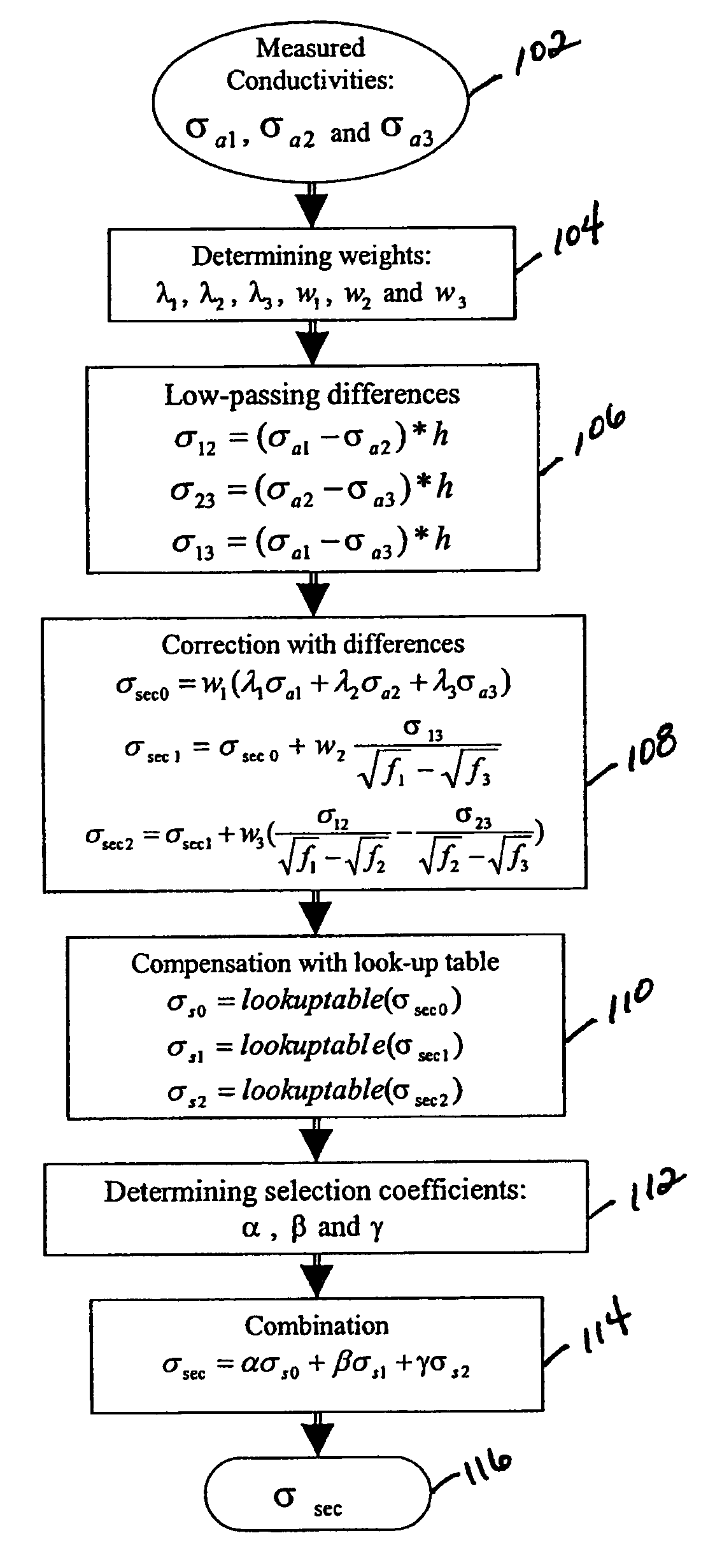
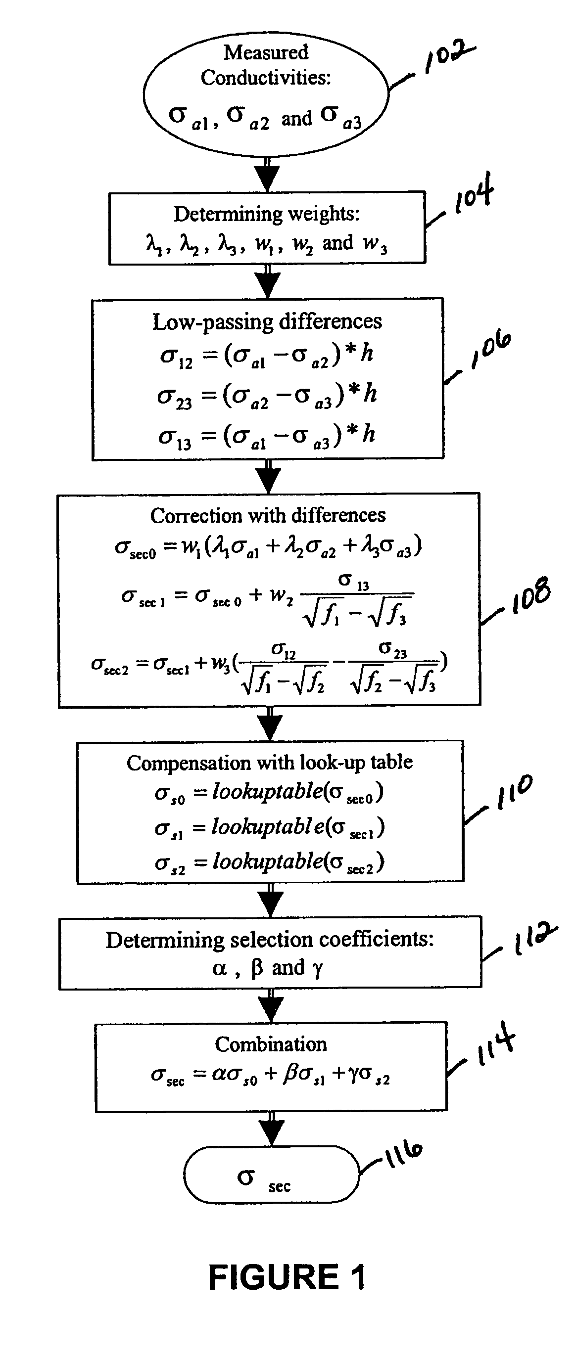
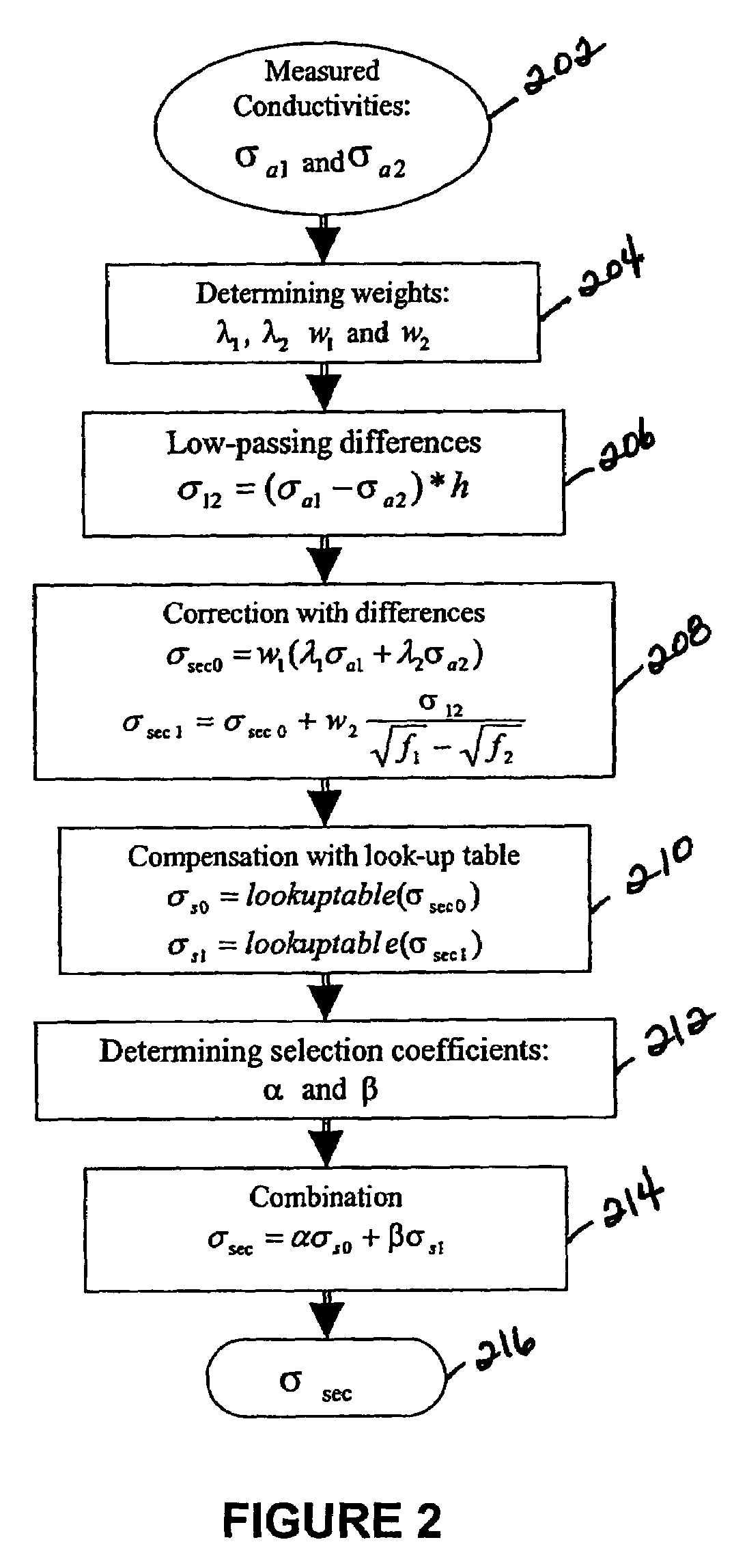
Induction logging system and method featuring multi-frequency skin effect correction
PatentInactiveUS7010429B2
Innovation
- A method that corrects the skin effect using a limited number of in-phase signal measurements at different frequencies, determining weighting coefficients and low-pass filtered conductivity differences to calculate compensated conductivities, eliminating the need for quadrature signal measurements and enhancing noise control.

System and method for elevated source to borehole electromagnetic survey
PatentActiveUS20100225322A1
Innovation
- A Mobile Elevated Transmitter to Borehole Receiver EM system is deployed, using a high-power, mobile elevated source suspended from a helicopter or airplane, combined with an array of borehole and optional surface or airborne receivers, allowing for increased source location density and efficient 3D surveying by focusing measurements on the near-well formation while maintaining sensitivity near the transmitter and receiver positions.


Environmental Impact Assessment of EM Survey Operations
Electromagnetic induction surveys for geological mapping present relatively minimal environmental impacts compared to other geophysical exploration methods, yet comprehensive assessment remains essential for sustainable operations. The non-invasive nature of EM surveys eliminates the need for drilling, excavation, or chemical substances, significantly reducing direct environmental disturbance. However, several environmental considerations require careful evaluation during survey planning and execution phases.
Physical footprint represents the primary environmental concern, as survey operations require access routes and equipment positioning across diverse terrains. Ground-based EM surveys typically involve lightweight portable equipment that minimizes soil compaction and vegetation damage. Airborne EM systems further reduce surface impact by eliminating ground contact entirely, though helicopter operations introduce noise pollution and potential wildlife disturbance considerations.
Electromagnetic field exposure constitutes another assessment parameter, though EM survey systems operate at power levels well below established safety thresholds for both human exposure and electronic interference. The low-frequency electromagnetic fields generated during surveys dissipate rapidly with distance and duration, presenting negligible long-term environmental effects. Wildlife impact studies indicate minimal behavioral disruption, as most survey frequencies fall outside sensitive biological response ranges.
Operational logistics present secondary environmental considerations including fuel consumption for equipment and transportation, temporary infrastructure requirements, and waste generation from field operations. Modern EM survey practices emphasize leave-no-trace principles, requiring complete site restoration following data collection activities.
Regulatory compliance frameworks increasingly mandate environmental impact assessments for geophysical surveys, particularly in sensitive ecological areas, protected lands, or regions with endangered species habitats. Assessment protocols typically evaluate cumulative impacts when multiple survey techniques are employed simultaneously, seasonal timing restrictions to avoid critical wildlife periods, and long-term monitoring requirements for repeated survey campaigns.
Mitigation strategies focus on optimized survey design to minimize operational footprint, seasonal scheduling to avoid environmentally sensitive periods, and integration with existing access infrastructure to reduce new disturbance. Advanced survey planning utilizing satellite imagery and GIS analysis enables precise route optimization while avoiding ecologically sensitive areas.
Data Processing and AI Integration in EM Geological Analysis
The integration of advanced data processing techniques and artificial intelligence has revolutionized electromagnetic geological analysis, transforming raw field measurements into actionable geological insights. Modern EM surveys generate massive datasets that require sophisticated computational approaches to extract meaningful subsurface information effectively.
Traditional data processing workflows in electromagnetic geological mapping involve multiple stages of signal conditioning, noise reduction, and inversion algorithms. Contemporary systems employ advanced filtering techniques including wavelet transforms and adaptive noise cancellation to enhance signal-to-noise ratios. These preprocessing steps are crucial for removing cultural interference, instrument drift, and environmental noise that can mask genuine geological signatures.
Machine learning algorithms have emerged as powerful tools for pattern recognition in electromagnetic data interpretation. Supervised learning models, trained on extensive geological databases, can automatically identify subsurface features such as ore bodies, groundwater aquifers, and geological boundaries. Deep neural networks demonstrate particular effectiveness in recognizing complex conductivity patterns that traditional analytical methods might overlook.
Artificial intelligence integration extends beyond simple pattern matching to encompass predictive modeling and uncertainty quantification. Ensemble methods combining multiple AI algorithms provide robust geological interpretations while quantifying confidence levels. These approaches significantly reduce interpretation time while maintaining high accuracy standards essential for geological decision-making.
Real-time data processing capabilities enabled by AI integration allow for adaptive survey design and immediate field validation. Edge computing solutions process electromagnetic measurements on-site, providing instant feedback to field teams and enabling dynamic survey optimization. This capability proves particularly valuable in challenging terrain where survey modifications can significantly impact data quality.
Cloud-based processing platforms facilitate collaborative interpretation workflows, enabling geophysicists worldwide to contribute expertise to complex geological problems. These systems leverage distributed computing resources to handle computationally intensive inversion algorithms and support comprehensive uncertainty analysis across multiple geological scenarios.
Unlock deeper insights with Patsnap Eureka Quick Research — get a full tech report to explore trends and direct your research. Try now!
Generate Your Research Report Instantly with AI Agent
Supercharge your innovation with Patsnap Eureka AI Agent Platform!