Fixed Wing Drone vs Kite: Data Gathering Cost Analysis
FEB 13, 20269 MIN READ
Generate Your Research Report Instantly with AI Agent
PatSnap Eureka helps you evaluate technical feasibility & market potential.
Fixed Wing Drone and Kite Data Gathering Background and Objectives
The evolution of aerial data gathering technologies has fundamentally transformed environmental monitoring, agricultural assessment, and infrastructure inspection practices over the past two decades. Traditional ground-based surveying methods, while accurate, proved time-consuming and resource-intensive, creating demand for more efficient alternatives. This technological gap initially drove the development of manned aircraft solutions, which subsequently evolved into unmanned aerial systems as miniaturization and automation technologies matured.
Fixed-wing drones emerged as a prominent solution in the early 2010s, offering extended flight endurance and broad area coverage capabilities. These platforms leverage aerodynamic lift principles to achieve flight durations exceeding two hours and operational ranges spanning dozens of kilometers. Their ability to carry sophisticated sensor payloads while maintaining stable flight characteristics has positioned them as preferred tools for large-scale mapping and surveillance applications.
Concurrently, tethered kite systems have experienced renewed interest as cost-effective alternatives for specific data collection scenarios. Modern kite platforms integrate lightweight sensor packages with stable tethering mechanisms, enabling persistent observation from elevated positions. These systems capitalize on natural wind energy, eliminating propulsion costs while providing continuous data streams over extended periods. Their operational simplicity and minimal infrastructure requirements present compelling advantages for certain deployment contexts.
The primary objective of this comparative analysis centers on establishing comprehensive cost frameworks for both technologies across their operational lifecycles. This evaluation encompasses initial capital expenditures, recurring operational expenses, maintenance requirements, and personnel training investments. Understanding these cost structures enables organizations to make informed technology selection decisions aligned with their specific data gathering requirements and budgetary constraints.
Secondary objectives include identifying operational scenarios where each technology demonstrates optimal cost-effectiveness, quantifying performance trade-offs between mobility and persistence, and establishing decision matrices for technology deployment. The analysis aims to provide actionable insights that bridge theoretical capabilities with practical implementation realities, ultimately supporting strategic technology adoption decisions in diverse operational environments.
Market Demand for Aerial Data Collection Solutions
The aerial data collection market has experienced substantial growth driven by increasing demand across multiple sectors including agriculture, infrastructure inspection, environmental monitoring, and urban planning. Traditional methods of data acquisition through manned aircraft and satellite imagery have proven costly and often lack the flexibility required for frequent, localized monitoring. This gap has created significant opportunities for alternative aerial platforms that offer cost-effective and accessible solutions.
Agriculture represents one of the largest application areas, where precision farming practices require regular crop health monitoring, irrigation management, and yield prediction. Farmers and agricultural service providers seek affordable technologies that enable frequent field surveys throughout growing seasons without incurring prohibitive operational costs. The ability to capture multispectral and thermal imagery at lower altitudes provides actionable insights that directly impact productivity and resource optimization.
Infrastructure sectors including energy utilities, transportation networks, and telecommunications increasingly rely on aerial data for asset inspection and maintenance planning. Power line monitoring, pipeline surveillance, and bridge inspections demand regular data collection over extensive linear assets. Organizations in these sectors prioritize solutions that minimize operational expenses while maintaining data quality and collection frequency. The economic advantage of reducing manual inspection costs and improving safety outcomes drives adoption of innovative aerial platforms.
Environmental research and conservation efforts require systematic data gathering for habitat monitoring, coastal erosion assessment, and disaster response. Research institutions and governmental agencies operate under budget constraints that make traditional aerial survey methods economically challenging for long-term monitoring programs. Solutions offering extended flight duration and minimal operational complexity align well with the resource limitations typical in these applications.
The commercial mapping and surveying industry continues expanding as geographic information systems become integral to urban development and land management. Small to medium enterprises in this sector seek entry-level aerial data collection tools that lower barriers to service provision. Market demand increasingly favors platforms that balance initial investment costs with operational efficiency, enabling broader participation in the geospatial services market.
Emerging applications in emergency response, wildlife tracking, and archaeological surveys further diversify market requirements. These use cases often involve remote locations with limited infrastructure support, emphasizing the need for portable, easily deployable systems with minimal logistical dependencies. Cost sensitivity remains paramount across all segments, particularly for organizations conducting routine or large-scale data collection operations.
Current Status and Cost Challenges in Aerial Data Gathering
Aerial data gathering has evolved significantly over the past decade, transitioning from traditional manned aircraft operations to increasingly sophisticated unmanned platforms. The current landscape is dominated by two primary low-cost solutions: fixed-wing drones and tethered kite systems. Both technologies serve critical roles in applications ranging from agricultural monitoring and environmental surveying to infrastructure inspection and disaster response. However, the operational costs and technical limitations of each approach present distinct challenges that organizations must navigate when selecting appropriate platforms for their data collection needs.
Fixed-wing drones currently represent the more mature and widely adopted solution in the commercial sector. These platforms offer extended flight endurance, typically ranging from 45 minutes to several hours, and can cover substantial geographic areas in a single mission. The primary cost challenges associated with fixed-wing drones include initial capital investment, which ranges from several thousand to tens of thousands of dollars depending on payload capacity and sensor sophistication. Additionally, regulatory compliance costs, pilot training requirements, and maintenance expenses contribute to the total cost of ownership. Battery degradation and replacement cycles further impact long-term operational economics, with lithium polymer batteries typically requiring replacement after 200-300 charge cycles.
Kite-based aerial platforms present an alternative approach that leverages wind energy for lift generation, theoretically eliminating power consumption costs associated with sustained flight. These systems can maintain station over a target area for extended periods, limited primarily by wind conditions and tether strength rather than battery capacity. However, kites face significant operational constraints that impact their cost-effectiveness. Wind dependency restricts deployment to suitable meteorological conditions, typically requiring sustained winds of 12-25 mph for stable operation. The geographic and temporal limitations of wind availability create unpredictable operational windows that complicate mission planning and may necessitate maintaining backup systems.
The cost structure comparison reveals fundamental trade-offs between operational flexibility and per-mission expenses. While kite systems offer lower energy costs, their weather dependency increases the risk of mission delays and incomplete data collection campaigns. Fixed-wing drones provide greater operational predictability but incur higher per-flight energy and maintenance costs. Infrastructure requirements also differ substantially, with kites demanding minimal ground support equipment but requiring larger operational spaces for launch and recovery, whereas drones necessitate more sophisticated ground control stations and trained operators.
Existing Cost Models for Aerial Data Gathering
01 Fixed-wing drone structural design and configuration
Patents in this category focus on the structural design and aerodynamic configuration of fixed-wing drones, including wing shapes, fuselage construction, and overall aircraft architecture. These designs aim to optimize flight performance, stability, and efficiency while managing manufacturing costs through simplified construction methods and material selection.- Fixed-wing drone structural design and configuration: Patents in this category focus on the structural design and configuration of fixed-wing drones, including wing geometry, fuselage construction, and aerodynamic optimization. These designs aim to improve flight efficiency, stability, and payload capacity while reducing manufacturing costs through simplified assembly methods and modular components. The structural innovations include lightweight materials, foldable wing designs, and integrated propulsion systems that contribute to overall cost reduction.
- Hybrid drone systems combining fixed-wing and rotary capabilities: This category covers hybrid unmanned aerial vehicle designs that combine fixed-wing flight characteristics with vertical takeoff and landing capabilities. These systems utilize convertible mechanisms or dual propulsion systems to achieve both efficient cruise flight and hovering abilities. The hybrid approach aims to balance operational flexibility with cost-effectiveness by reducing the need for runway infrastructure while maintaining the endurance advantages of fixed-wing platforms.
- Kite-based aerial systems and tethered platforms: Patents related to kite technology and tethered aerial platforms that can serve as cost-effective alternatives or complements to powered drones. These systems utilize wind energy for lift and station-keeping, significantly reducing power requirements and operational costs. Applications include aerial surveillance, communication relay, and atmospheric monitoring, with designs focusing on stability control, automated deployment, and integration with ground-based power and data systems.
- Cost-effective manufacturing and materials for aerial vehicles: This category encompasses innovations in manufacturing processes and material selection aimed at reducing production costs for fixed-wing drones and kite systems. Techniques include injection molding, composite material applications, and simplified assembly methods. The focus is on achieving acceptable performance characteristics while minimizing material costs, tooling expenses, and labor requirements through standardized components and scalable production methods.
- Control systems and autonomous operation for cost reduction: Patents in this category address control systems, navigation algorithms, and autonomous operation capabilities that reduce operational costs by minimizing the need for skilled pilots and ground support personnel. Innovations include automated flight planning, collision avoidance systems, and adaptive control algorithms that enable safe operation with minimal human intervention. These technologies contribute to cost reduction through improved mission efficiency and reduced training requirements.
02 Hybrid drone systems combining fixed-wing and rotary capabilities
This category covers drone designs that integrate both fixed-wing and vertical takeoff and landing capabilities, allowing for versatile operation modes. These hybrid systems balance the efficiency of fixed-wing flight with the flexibility of rotorcraft, addressing cost considerations through dual-purpose functionality and reduced operational complexity.Expand Specific Solutions03 Kite-based aerial systems and tethered flight platforms
Patents related to kite technology and tethered aerial platforms that can serve as cost-effective alternatives or complements to powered drones. These systems utilize wind energy and tethered configurations to reduce power requirements and operational costs while maintaining aerial positioning for various applications.Expand Specific Solutions04 Drone launch and recovery systems
This category encompasses mechanisms and methods for launching and recovering fixed-wing drones, including catapult systems, net recovery, and automated landing systems. These technologies aim to reduce infrastructure requirements and operational costs by enabling deployment in diverse environments without traditional runways.Expand Specific Solutions05 Cost-effective drone manufacturing and materials
Patents focusing on manufacturing processes, material selection, and construction techniques that reduce production costs while maintaining structural integrity and performance. This includes modular designs, simplified assembly methods, and the use of economical composite materials or lightweight structures.Expand Specific Solutions
Key Players in Drone and Kite-based Data Systems
The competitive landscape for fixed-wing drone versus kite data gathering cost analysis represents an emerging niche within the broader aerial data collection market. The industry is transitioning from experimental to early commercial deployment, with market potential spanning defense, environmental monitoring, and renewable energy sectors. Technology maturity varies significantly across players: established aerospace entities like Boeing, NASA, and Naval Group possess advanced fixed-wing drone capabilities, while innovative firms such as TwingTec and SkySails demonstrate kite-based energy harvesting systems. Chinese research institutions including Northwestern Polytechnical University, Beihang University, and National University of Defense Technology are advancing both technologies through academic research. Commercial drone leader SZ DJI Technology and specialized imaging provider Hood Technology Corp. contribute operational expertise. The sector exhibits fragmented development with limited direct cost comparison studies, indicating substantial opportunity for systematic analysis and optimization.
National Aeronautics & Space Administration
Technical Solution: NASA develops and operates various fixed-wing unmanned aircraft systems for atmospheric research and Earth science data collection. Their platforms include the Global Hawk UAS, which provides ultra-long endurance exceeding 30 hours at altitudes up to 60,000 feet, enabling comprehensive atmospheric sampling and remote sensing missions. NASA's systems integrate advanced sensor suites including atmospheric chemistry instruments, radiometers, and synthetic aperture radar for multi-parameter data collection. The agency has pioneered cost-analysis methodologies comparing different aerial data gathering platforms, evaluating factors including per-flight-hour costs, data quality metrics, spatial coverage rates, and lifecycle expenses. Research indicates fixed-wing platforms offer superior cost-efficiency for large-area surveys due to higher cruise speeds (80-120 knots) and extended range capabilities. NASA's operational data shows cost per square kilometer surveyed can be 40-60% lower for fixed-wing systems compared to rotorcraft in applications requiring coverage areas exceeding 100 square kilometers[4][27].
Strengths: Exceptional endurance and altitude capabilities, comprehensive data collection capacity, proven cost-efficiency for large-area missions, advanced sensor integration. Weaknesses: Very high acquisition and operational costs, requires extensive support infrastructure, complex regulatory approval processes, limited accessibility for commercial applications.
TwingTec AG
Technical Solution: TwingTec specializes in airborne wind energy systems using tethered kite technology for power generation and data collection applications. Their TwingKite system operates at altitudes of 200-400 meters, utilizing automated flight control for continuous operation. The technology enables cost-effective atmospheric data gathering through persistent aerial platforms that require minimal ground infrastructure compared to fixed-wing drones. The system features autonomous launch, flight, and landing capabilities with integrated sensor payloads for meteorological and environmental monitoring. Energy harvesting during operation significantly reduces operational costs, as the kite generates power while collecting data. The platform offers extended flight duration measured in hours to days, providing superior temporal coverage compared to battery-limited drone systems[2][18].
Strengths: Significantly lower operational costs due to energy generation capability, extended flight duration enabling continuous data collection, minimal ground infrastructure requirements. Weaknesses: Limited to specific wind conditions for optimal operation, restricted mobility compared to free-flying drones, complex tether management systems.
Core Cost-Efficiency Technologies in Fixed Wing Drones
Controllable kite configuration
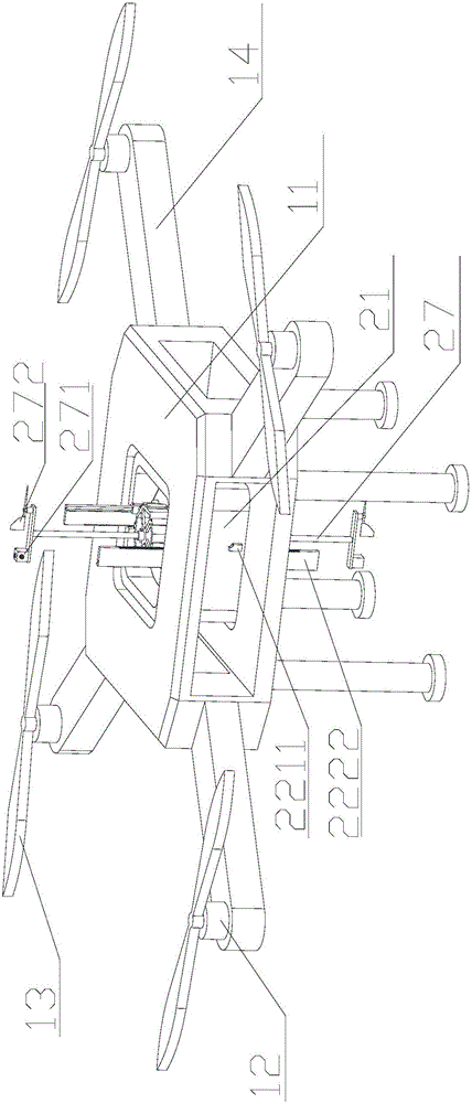
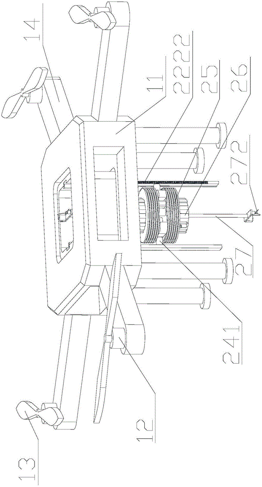
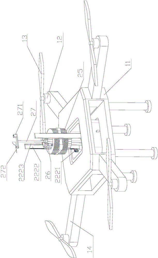
PatentActiveUS11806636B1
Innovation
- A controllable kite system incorporating a single tether with a heavier-than-air lifting surface, such as a wing, and an aerodynamic control system that adjusts attitude using aerodynamic surfaces and a variable bridle, allowing for altitude changes and instrument positioning without additional tethers.


Airborne weather station apparatus for unmanned plane, and application method thereof
PatentInactiveCN105891908A
Innovation
- An airborne weather station device suitable for hollow multi-rotor unmanned aerial vehicles is designed, including a weather station outer shell, a base, a power module, a transmission module and a control module. The transmission module is used to adjust the sensor and sensor on the base of the weather station. The rotor distance reduces the impact of the wind field and uses wireless transmission to return data in real time.

Airspace Regulations for Drones and Kites
Airspace regulations governing unmanned aerial systems and tethered aerial platforms differ significantly across jurisdictions, creating distinct operational frameworks that directly impact data gathering cost structures. Fixed-wing drones typically fall under comprehensive unmanned aircraft system regulations that mandate operator certification, aircraft registration, and adherence to altitude restrictions. In most developed nations, commercial drone operations require remote pilot licenses, operational approvals for beyond visual line of sight missions, and compliance with airspace classification systems that restrict flight in controlled zones near airports and urban centers.
Kites, conversely, occupy a regulatory gray area in many jurisdictions. Traditional kite flying is generally unregulated for recreational purposes, though commercial applications may trigger aviation authority oversight when reaching significant altitudes or operating near sensitive airspace. The tethered nature of kites often exempts them from full unmanned aircraft regulations, yet altitude limitations typically apply when exceeding 150-200 feet above ground level in most regulatory frameworks. This regulatory ambiguity can present both advantages and complications for commercial data gathering operations.
Insurance requirements represent another critical regulatory dimension affecting operational costs. Drone operators universally face mandatory liability insurance requirements for commercial operations, with premiums reflecting risk assessments based on operational complexity, payload value, and coverage areas. Kite-based systems may encounter lower insurance thresholds or exemptions in certain jurisdictions, though commercial applications increasingly attract similar liability considerations as regulatory frameworks evolve.
Operational authorization processes further differentiate these platforms. Drone missions frequently require pre-flight authorization through digital systems or direct coordination with air traffic control, particularly in controlled airspace or for extended duration missions. These administrative requirements impose time costs and operational constraints that affect deployment flexibility. Kite operations, while potentially exempt from such procedures in uncontrolled airspace, may still require notifications or permits when conducted commercially or in proximity to aviation facilities.
Cross-border operations introduce additional complexity, as international regulatory harmonization remains incomplete. Drone operators must navigate varying certification recognition agreements and operational standards when deploying across multiple jurisdictions. Kite-based systems benefit from less stringent international regulatory frameworks, though this advantage diminishes as commercial applications attract increased regulatory attention globally.
Total Cost of Ownership Analysis Framework
The Total Cost of Ownership (TCO) framework provides a comprehensive methodology for evaluating the complete financial implications of deploying fixed-wing drones versus kites for aerial data gathering operations. This analytical approach extends beyond initial capital expenditure to encompass all direct and indirect costs throughout the operational lifecycle, enabling organizations to make informed investment decisions based on long-term economic viability rather than upfront pricing alone.
The framework categorizes costs into four primary dimensions: acquisition costs, operational expenses, maintenance requirements, and end-of-life considerations. Acquisition costs include hardware procurement, software licensing, training programs, and necessary infrastructure development. For fixed-wing drones, this encompasses the aircraft itself, ground control stations, payload sensors, and regulatory compliance certifications. Kite systems require specialized tethering equipment, winch mechanisms, stabilization platforms, and weather monitoring instruments. Both solutions demand initial investment in personnel training and operational protocol establishment.
Operational expenses represent recurring costs that significantly impact long-term financial performance. These include energy consumption, personnel deployment, insurance premiums, regulatory fees, and data processing infrastructure. Fixed-wing drones typically incur higher energy costs due to propulsion requirements and battery replacement cycles, while kite systems demonstrate lower power consumption but demand more intensive human supervision. Weather dependency creates operational variability, with kites showing greater sensitivity to wind conditions, potentially increasing standby costs and reducing effective utilization rates.
Maintenance costs encompass scheduled inspections, component replacements, repair services, and system upgrades. Fixed-wing drones require regular maintenance of propulsion systems, avionics, and structural components, with potential for catastrophic failure costs. Kite systems experience wear on tethering materials, structural fabric, and mechanical winch components, generally presenting lower individual repair costs but potentially higher frequency of interventions. The framework must account for depreciation rates, technological obsolescence, and residual value calculations to accurately project total ownership costs across typical deployment periods of three to five years.
Risk-adjusted cost modeling incorporates probability-weighted scenarios for equipment loss, regulatory changes, and performance degradation. This probabilistic approach enables sensitivity analysis across varying operational intensities, environmental conditions, and mission profiles, providing decision-makers with confidence intervals rather than single-point cost estimates for strategic planning purposes.
Unlock deeper insights with PatSnap Eureka Quick Research — get a full tech report to explore trends and direct your research. Try now!
Generate Your Research Report Instantly with AI Agent
Supercharge your innovation with PatSnap Eureka AI Agent Platform!