

High Pass Filter Solutions for Enhancing Geospatial Satellite Data Analysis
JUL 28, 20259 MIN READ
Generate Your Research Report Instantly with AI Agent
PatSnap Eureka helps you evaluate technical feasibility & market potential.
Geospatial HPF Background
High Pass Filter (HPF) techniques have been integral to geospatial satellite data analysis since the early days of remote sensing. Originating from signal processing theory, HPF was first applied to satellite imagery in the 1970s to enhance spatial resolution and extract fine details from multispectral data. The fundamental principle behind HPF is its ability to emphasize high-frequency components while attenuating low-frequency information in spatial data.
The evolution of HPF in geospatial applications has been closely tied to advancements in satellite technology and image processing capabilities. As satellite sensors improved in spatial, spectral, and radiometric resolution, the need for more sophisticated HPF algorithms grew. Early implementations focused on simple edge detection and sharpening, while modern approaches incorporate adaptive filtering, multi-scale analysis, and machine learning techniques to optimize filter performance across diverse landscapes and data types.
In the context of satellite data analysis, HPF serves several critical functions. It is particularly effective in enhancing linear features such as roads, rivers, and urban infrastructure, which are often crucial for land use classification, change detection, and urban planning. HPF also plays a vital role in pan-sharpening, a process that combines high-resolution panchromatic data with lower-resolution multispectral imagery to create high-resolution color images.
The application of HPF in geospatial analysis extends beyond visual enhancement. It is instrumental in geological studies for identifying fault lines and mineral deposits, in agricultural monitoring for detecting crop stress and estimating yields, and in environmental assessments for tracking deforestation and coastal erosion. Moreover, HPF techniques have proven valuable in atmospheric correction processes, helping to mitigate the effects of haze and improve overall image clarity.
Recent developments in HPF methodologies have focused on addressing the challenges posed by the increasing volume and complexity of satellite data. This includes the development of computationally efficient algorithms capable of processing large datasets in near real-time, as well as the integration of HPF with other advanced image processing techniques such as object-based image analysis and deep learning models.
As the field of geospatial satellite data analysis continues to evolve, HPF remains a fundamental tool in the remote sensing toolkit. Its ongoing refinement and adaptation to new data sources and analytical needs underscore its enduring importance in extracting meaningful information from satellite imagery and supporting a wide range of Earth observation applications.
Satellite Data Analysis Needs
Satellite data analysis has become an indispensable tool in various fields, including environmental monitoring, urban planning, agriculture, and disaster management. The increasing demand for high-resolution and accurate geospatial information has driven the need for advanced satellite data analysis techniques. High-pass filter solutions have emerged as a crucial component in enhancing the quality and interpretability of satellite imagery.
The primary market demand for satellite data analysis stems from government agencies, research institutions, and private sector organizations seeking to extract valuable insights from Earth observation data. These stakeholders require sophisticated tools to process and analyze vast amounts of satellite imagery, often in near real-time, to support decision-making processes and policy formulation.
In the environmental sector, there is a growing need for accurate monitoring of deforestation, land use changes, and climate-related phenomena. High-pass filter solutions can significantly improve the detection of fine-scale features and subtle changes in vegetation patterns, enabling more precise assessments of environmental impacts and trends.
Urban planners and infrastructure developers rely on satellite data analysis to map and monitor urban growth, assess land cover changes, and plan sustainable development initiatives. The application of high-pass filters can enhance the detection of urban features, such as buildings, roads, and other infrastructure, facilitating more accurate urban modeling and planning.
The agriculture industry has witnessed a surge in demand for precision farming techniques, where satellite data analysis plays a crucial role. High-pass filter solutions can improve the detection of crop health variations, soil moisture levels, and pest infestations, enabling farmers to optimize resource allocation and increase crop yields.
Disaster management and emergency response organizations require rapid and accurate analysis of satellite imagery to assess damage, plan relief efforts, and monitor recovery progress. High-pass filters can enhance the visibility of disaster-affected areas, allowing for more efficient and targeted response strategies.
The defense and intelligence sectors have a persistent demand for high-quality satellite imagery analysis to support strategic decision-making and surveillance operations. Advanced filtering techniques are essential for detecting and identifying objects of interest, monitoring border activities, and assessing potential security threats.
As the volume and complexity of satellite data continue to grow, there is an increasing need for automated and scalable analysis solutions. Machine learning and artificial intelligence algorithms, combined with high-pass filter techniques, are becoming increasingly important in extracting meaningful information from large-scale satellite datasets.
HPF Challenges in Geospatial
High Pass Filter (HPF) solutions face several challenges in the context of geospatial satellite data analysis. These challenges stem from the complex nature of satellite imagery and the diverse requirements of geospatial applications.
One of the primary challenges is the preservation of fine details and edge information while effectively removing low-frequency noise. Satellite images often contain valuable high-frequency information, such as urban structures, coastlines, and geological features. HPF must be carefully designed to enhance these details without introducing artifacts or distorting the original data.
Another significant challenge is the variability in spatial resolution across different satellite sensors. HPF techniques need to be adaptable to various resolutions, from low-resolution weather satellites to high-resolution Earth observation platforms. This variability requires flexible filter designs that can be optimized for different spatial scales and data characteristics.
The presence of atmospheric effects and sensor noise in satellite imagery poses additional challenges for HPF implementation. These distortions can manifest as low-frequency components that need to be separated from genuine surface features. Developing robust HPF algorithms that can distinguish between atmospheric interference and true ground information is crucial for accurate geospatial analysis.
Computational efficiency is also a major concern, particularly when processing large volumes of satellite data. HPF operations can be computationally intensive, especially for high-resolution imagery covering vast geographical areas. Optimizing filter algorithms for parallel processing and leveraging GPU acceleration are essential considerations for practical implementation in geospatial workflows.
The multispectral nature of many satellite sensors introduces complexity in HPF application. Different spectral bands may require varying levels of high-pass filtering, necessitating band-specific filter designs or adaptive approaches that can handle multi-channel data effectively.
Furthermore, the integration of HPF within broader image processing pipelines presents challenges in maintaining radiometric and geometric accuracy. Ensuring that the filtered output remains consistent with other processing steps, such as atmospheric correction and orthorectification, is critical for downstream analysis tasks.
Lastly, the validation and quality assessment of HPF results in geospatial applications can be challenging due to the lack of ground truth data in many cases. Developing robust metrics and validation methodologies to quantify the effectiveness of HPF in enhancing satellite imagery for various geospatial applications remains an ongoing research challenge.
Current HPF Implementations
01 High-pass filter design for signal processing
High-pass filters are designed to attenuate low-frequency signals while allowing high-frequency signals to pass through. These filters are used in various signal processing applications to enhance data quality by removing unwanted low-frequency components or noise. The design of high-pass filters often involves careful selection of cutoff frequencies and filter characteristics to achieve optimal performance for specific applications.- High-pass filter design for signal processing: High-pass filters are used in signal processing to attenuate low-frequency components while allowing high-frequency components to pass through. These filters can be implemented using various circuit designs and digital signal processing techniques to enhance data quality and remove unwanted noise or interference.
- Image and video enhancement using high-pass filtering: High-pass filtering techniques are applied to enhance image and video quality by sharpening edges, improving contrast, and removing low-frequency noise. These methods can be used in various applications, including digital cameras, video processing systems, and medical imaging devices.
- Audio signal enhancement with high-pass filters: High-pass filters are employed in audio processing to enhance sound quality by removing low-frequency noise, reducing rumble, and improving clarity. These filters can be implemented in various audio devices, including speakers, headphones, and recording equipment.
- Data enhancement in communication systems: High-pass filtering techniques are used in communication systems to enhance data transmission by reducing low-frequency interference, improving signal-to-noise ratio, and optimizing channel capacity. These methods can be applied in various communication technologies, including wireless, optical, and satellite systems.
- High-pass filter implementation in integrated circuits: High-pass filters are implemented in integrated circuits using various techniques, such as active and passive filter designs, switched-capacitor circuits, and digital filter algorithms. These implementations aim to optimize performance, reduce power consumption, and minimize chip area for data enhancement applications.
02 Image and video enhancement using high-pass filtering
High-pass filtering techniques are applied to image and video data to enhance details and improve overall quality. These methods can sharpen edges, increase contrast, and remove low-frequency noise or artifacts. By isolating and amplifying high-frequency components, high-pass filters can reveal fine details that may be obscured in the original data, resulting in clearer and more visually appealing images or videos.Expand Specific Solutions03 Audio signal enhancement using high-pass filters
High-pass filters are employed in audio signal processing to enhance sound quality by removing low-frequency noise or unwanted bass components. This technique can improve clarity and intelligibility of speech, music, or other audio signals. High-pass filtering in audio applications often involves careful tuning to preserve desired low-frequency content while eliminating problematic frequencies.Expand Specific Solutions04 High-pass filter implementation in digital systems
Digital implementations of high-pass filters are widely used in modern signal processing systems. These digital filters can be realized through various techniques, including finite impulse response (FIR) and infinite impulse response (IIR) designs. Digital high-pass filters offer advantages such as programmability, stability, and precise control over filter characteristics, making them suitable for a wide range of data enhancement applications.Expand Specific Solutions05 Adaptive high-pass filtering for noise reduction
Adaptive high-pass filtering techniques dynamically adjust filter parameters based on input signal characteristics or environmental conditions. These methods can effectively reduce noise and enhance signal quality in varying or unpredictable environments. Adaptive high-pass filters are particularly useful in applications where noise characteristics change over time or where optimal filter settings may vary depending on the input signal.Expand Specific Solutions
Key Geospatial Data Players
The high pass filter solutions for enhancing geospatial satellite data analysis market is in a growth phase, driven by increasing demand for precise positioning and remote sensing applications. The global market size is expanding, with projections indicating significant growth in the coming years. Technologically, the field is advancing rapidly, with companies like Trimble Navigation, China Academy of Space Technology, and Swift Navigation leading innovation. These firms are developing sophisticated algorithms and hardware to improve data accuracy and processing capabilities. The technology's maturity varies across applications, with some areas like precision agriculture and autonomous vehicles seeing more advanced implementations, while others are still in early development stages.
Trimble Navigation Ltd.
Technical Solution: Trimble Navigation Ltd. has developed a sophisticated HPF solution tailored for geospatial satellite data analysis in precision agriculture and land surveying applications. Their approach combines traditional spatial domain filtering with frequency domain techniques to enhance the clarity of satellite imagery. Trimble's HPF solution incorporates a proprietary edge-preserving algorithm that maintains sharp boundaries between different land features while effectively removing low-frequency noise[5]. The company has also integrated their HPF technology with their existing GIS software suite, allowing for seamless incorporation of enhanced satellite data into various geospatial analysis workflows. Trimble's solution includes a user-friendly interface for customizing filter parameters, making it accessible to both expert and non-expert users in the field[6].
Strengths: Specialized for precision agriculture and surveying, seamless integration with existing GIS software, and user-friendly customization options. Weaknesses: May be less versatile for applications outside of Trimble's core focus areas.
Beihang University
Technical Solution: Beihang University has developed an innovative HPF solution for geospatial satellite data analysis, focusing on improving the detection and analysis of small-scale features in urban environments. Their approach combines traditional HPF techniques with advanced computer vision algorithms to enhance the resolution and clarity of satellite imagery. The university's research team has implemented a novel multi-resolution HPF framework that adaptively applies different filter strengths to various spatial scales, allowing for simultaneous enhancement of both large-scale structures and fine details[7]. Additionally, they have developed a deep learning-based post-processing step that further refines the filtered images, reducing artifacts and improving overall image quality. The solution also incorporates a spectral unmixing technique to better distinguish between different urban materials and structures in multi-spectral satellite data[8].
Strengths: Specialized for urban feature detection, innovative multi-resolution framework, and integration of deep learning for image refinement. Weaknesses: May require extensive training data for optimal performance in diverse urban environments.
Innovative HPF Techniques
Method and apparatus for estimating position on basis of position-domain hatch filter by using multiple GNSS
PatentWO2019143006A1
Innovation
- A location area Hatch filter-based method utilizing multiple GNSS systems, including GPS, GLONASS, and BeiDou, to enhance satellite visibility, reduce computational complexity, and provide continuous and precise location estimation by using indirect measurements and Fault Detection and Isolation techniques.


Visualisation of extreme differences in contrast for camera systems
PatentInactiveEP1326431A2
Innovation
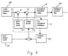
- Implementing a high-pass filter to enhance local contrast differences while weakening large differences, achieved through weighted subtraction of a low-pass filtered image, with the correction mask calculated asynchronously at most every second image, reducing computational effort and using existing hardware and software routines.
Environmental Impact Assessment
The implementation of High Pass Filter (HPF) solutions for enhancing geospatial satellite data analysis has significant implications for environmental impact assessment. These advanced filtering techniques enable more precise detection and monitoring of environmental changes, contributing to more accurate and timely assessments of human activities' effects on ecosystems.
By enhancing the clarity and resolution of satellite imagery, HPF solutions allow for improved identification of land use changes, deforestation patterns, and urban sprawl. This enhanced capability facilitates more comprehensive evaluations of habitat fragmentation and biodiversity loss. Environmental impact assessments can now incorporate finer-scale data on vegetation cover, water bodies, and soil conditions, leading to more nuanced understanding of ecosystem health and resilience.
The application of HPF in geospatial analysis also improves the detection of pollution sources and the tracking of pollutant dispersion. This is particularly valuable for assessing the environmental impact of industrial activities, agricultural practices, and urban development. The ability to discern subtle changes in water quality, air pollution patterns, and soil degradation enables more targeted and effective mitigation strategies.
Climate change impact assessments benefit significantly from the enhanced data quality provided by HPF solutions. The improved resolution allows for more accurate mapping of coastal erosion, glacier retreat, and changes in vegetation patterns associated with shifting climate zones. This data contributes to more robust climate models and predictions, informing adaptation and mitigation policies.
Furthermore, the use of HPF in satellite data analysis enhances the monitoring of protected areas and conservation efforts. It enables more effective tracking of illegal activities such as poaching and unauthorized resource extraction, supporting conservation management and policy enforcement. The improved data quality also allows for more accurate assessments of ecosystem services and natural capital, informing sustainable development strategies.
The integration of HPF-enhanced geospatial data into environmental impact assessments also improves the temporal resolution of monitoring efforts. This allows for more dynamic and responsive evaluations of environmental changes, enabling quicker identification of emerging threats and more timely implementation of protective measures. The ability to conduct frequent, high-quality assessments supports adaptive management approaches in environmental conservation and sustainable development.
Data Privacy and Security
In the context of high pass filter solutions for enhancing geospatial satellite data analysis, data privacy and security are paramount concerns that must be addressed comprehensively. The sensitive nature of satellite imagery and the potential for misuse necessitate robust protection measures throughout the data lifecycle.
Encryption plays a crucial role in safeguarding geospatial data during transmission and storage. Advanced encryption algorithms, such as AES-256, should be employed to protect data integrity and prevent unauthorized access. Implementing end-to-end encryption ensures that data remains secure from the point of capture to final analysis and storage.
Access control mechanisms are essential for managing user privileges and preventing data breaches. Multi-factor authentication, role-based access control (RBAC), and least privilege principles should be implemented to restrict data access to authorized personnel only. Regular audits and monitoring of user activities can help detect and prevent potential security threats.
Data anonymization techniques are vital when dealing with high-resolution satellite imagery that may contain personally identifiable information (PII) or sensitive locations. Techniques such as blurring, pixelation, or object removal can be applied to protect individual privacy while maintaining the overall utility of the data for analysis purposes.
Secure data storage and backup strategies are critical for protecting geospatial data from loss or corruption. Implementing redundant storage systems, regular backups, and disaster recovery plans ensures data availability and integrity. Cloud-based storage solutions with robust security measures can provide scalable and secure options for managing large volumes of satellite data.
Compliance with data protection regulations, such as GDPR or CCPA, is essential when handling geospatial data that may contain personal information. Organizations must implement data governance frameworks that address data collection, processing, and retention policies in accordance with relevant legal requirements.
Secure data sharing protocols are necessary for collaborative research and analysis. Implementing secure file transfer protocols, virtual private networks (VPNs), and data sharing agreements can facilitate safe and controlled data exchange between authorized parties while maintaining data confidentiality.
Regular security assessments and penetration testing should be conducted to identify and address potential vulnerabilities in the data processing and storage infrastructure. This proactive approach helps maintain the overall security posture of the geospatial data analysis system.
Unlock deeper insights with PatSnap Eureka Quick Research — get a full tech report to explore trends and direct your research. Try now!
Generate Your Research Report Instantly with AI Agent
Supercharge your innovation with PatSnap Eureka AI Agent Platform!