

Spatial Computing Platforms for Construction Planning
MAR 17, 20269 MIN READ
Generate Your Research Report Instantly with AI Agent
PatSnap Eureka helps you evaluate technical feasibility & market potential.
Spatial Computing in Construction Background and Objectives
The construction industry has undergone significant transformation over the past decades, evolving from traditional paper-based planning methods to digital workflows. However, the sector continues to face persistent challenges in project visualization, coordination, and execution. Spatial computing represents a paradigm shift that integrates digital information with physical space, offering unprecedented opportunities to revolutionize construction planning processes.
Spatial computing encompasses technologies such as augmented reality, virtual reality, mixed reality, and advanced 3D visualization systems that enable seamless interaction between digital models and real-world environments. In construction contexts, these technologies facilitate immersive project visualization, real-time collaboration, and enhanced decision-making capabilities throughout the planning phase.
The construction industry's adoption of Building Information Modeling has laid the groundwork for spatial computing integration. As projects become increasingly complex and stakeholder coordination more critical, traditional 2D drawings and static 3D models prove insufficient for comprehensive project understanding and effective communication among diverse project teams.
Current market drivers include the need for improved project accuracy, reduced rework costs, enhanced safety protocols, and accelerated project timelines. The COVID-19 pandemic has further accelerated digital transformation initiatives, highlighting the importance of remote collaboration tools and virtual project review capabilities.
The primary objective of spatial computing platform research in construction planning centers on developing comprehensive solutions that bridge the gap between digital design intent and physical construction reality. These platforms aim to provide intuitive interfaces for project stakeholders to visualize, analyze, and modify construction plans within spatially-aware environments.
Key technical objectives include achieving real-time rendering of complex building models, enabling multi-user collaborative experiences, integrating with existing construction software ecosystems, and providing accurate spatial tracking capabilities. The platforms must support various hardware configurations, from mobile devices to advanced head-mounted displays, ensuring accessibility across different user preferences and technical capabilities.
Strategic objectives encompass improving construction planning efficiency, reducing design errors and conflicts, enhancing stakeholder communication, and ultimately delivering higher-quality construction projects within optimized timeframes and budgets.
Market Demand for Digital Construction Planning Solutions
The construction industry is experiencing unprecedented digital transformation driven by mounting pressures for efficiency, sustainability, and cost optimization. Traditional construction planning methods, characterized by 2D drawings and fragmented workflows, are increasingly inadequate for managing complex modern projects. This fundamental shift has created substantial market demand for sophisticated digital construction planning solutions that can integrate spatial computing capabilities.
Market drivers stem from multiple converging factors. Rising construction costs and labor shortages have intensified the need for precise planning tools that minimize waste and optimize resource allocation. Regulatory requirements for environmental compliance and building performance standards demand more accurate predictive modeling capabilities. Additionally, the growing complexity of infrastructure projects requires enhanced visualization and coordination tools that traditional methods cannot provide.
The demand landscape reveals distinct segments with varying requirements. Large-scale infrastructure developers seek comprehensive platforms capable of handling massive datasets and complex geometries. Commercial construction firms prioritize solutions that streamline collaboration between architects, engineers, and contractors while reducing design conflicts. Residential developers focus on cost-effective tools that accelerate project timelines and improve quality control.
Geographic demand patterns show strong concentration in developed markets where construction digitization initiatives are most advanced. North American and European markets demonstrate high adoption rates for Building Information Modeling and related technologies, creating fertile ground for spatial computing platforms. Emerging markets in Asia-Pacific regions show rapidly growing interest as construction volumes increase and digital infrastructure improves.
Technology adoption barriers continue to influence market dynamics. Integration challenges with existing software ecosystems, high implementation costs, and workforce training requirements create hesitation among potential adopters. However, demonstrated return on investment through reduced rework, improved project delivery times, and enhanced safety outcomes are driving broader market acceptance.
The competitive landscape reflects diverse approaches to addressing market needs. Established CAD software providers are expanding their offerings to include spatial computing features, while specialized startups focus on niche applications like augmented reality visualization or automated clash detection. This diversity indicates robust market demand across multiple use cases and price points.
Future demand trajectories suggest continued growth driven by generational workforce changes and increasing project complexity. Younger professionals entering the construction industry expect digital-first workflows, while project stakeholders demand greater transparency and real-time collaboration capabilities that spatial computing platforms can uniquely provide.
Current State and Challenges of Spatial Computing Platforms
Spatial computing platforms for construction planning have emerged as transformative technologies that integrate digital and physical environments through advanced visualization, simulation, and interaction capabilities. Currently, these platforms leverage a combination of augmented reality (AR), virtual reality (VR), mixed reality (MR), and artificial intelligence to create immersive environments where construction professionals can visualize, analyze, and modify building designs in three-dimensional space.
The technological landscape is dominated by several key platform categories. Cloud-based spatial computing solutions offer scalable processing power for complex 3D modeling and real-time collaboration across distributed teams. Desktop and mobile applications provide accessibility for field workers and project managers, while specialized hardware systems deliver high-fidelity visualization experiences. Leading platforms integrate Building Information Modeling (BIM) data with spatial computing capabilities, enabling seamless transitions between design phases and construction execution.
Current implementations demonstrate varying levels of maturity across different geographical regions. North American and European markets show advanced adoption rates, particularly in large-scale commercial and infrastructure projects. Asian markets, led by Japan and South Korea, focus heavily on precision and automation integration. However, developing regions face significant barriers in platform adoption due to infrastructure limitations and cost considerations.
Despite technological advances, spatial computing platforms face substantial challenges that limit widespread adoption. Interoperability remains a critical issue, as different software ecosystems often operate in isolation, preventing seamless data exchange between design tools, project management systems, and construction equipment. This fragmentation creates workflow inefficiencies and increases project complexity.
Hardware limitations present another significant constraint. Current AR and VR devices suffer from limited battery life, processing power, and display resolution, which affects user experience during extended construction planning sessions. Additionally, the high cost of specialized hardware creates barriers for smaller construction firms and limits scalability across project teams.
Data management challenges compound these technical limitations. Construction projects generate massive datasets from multiple sources, including laser scanning, photogrammetry, IoT sensors, and design software. Current platforms struggle to process, synchronize, and visualize this information in real-time, particularly in complex multi-disciplinary projects where coordination between architectural, structural, and MEP systems is critical.
User adoption barriers also persist within the construction industry, which traditionally relies on established workflows and paper-based documentation. The learning curve associated with spatial computing interfaces, combined with concerns about technology reliability in harsh construction environments, slows implementation rates. Furthermore, regulatory frameworks have not yet adapted to accommodate spatial computing technologies, creating uncertainty around liability, data ownership, and quality assurance standards in digitally-planned construction projects.
Existing Spatial Computing Solutions for Construction Planning
01 Augmented Reality and Virtual Reality Integration
Spatial computing platforms integrate augmented reality (AR) and virtual reality (VR) technologies to create immersive experiences. These platforms utilize head-mounted displays, gesture recognition, and spatial mapping to overlay digital content onto the physical world or create fully virtual environments. The systems enable users to interact with three-dimensional digital objects in real-time, providing enhanced visualization and interaction capabilities for various applications including gaming, education, and professional training.- Augmented Reality and Virtual Reality Integration: Spatial computing platforms integrate augmented reality (AR) and virtual reality (VR) technologies to create immersive experiences. These platforms utilize head-mounted displays, sensors, and tracking systems to overlay digital content onto the physical world or create fully virtual environments. The integration enables users to interact with three-dimensional digital objects in real-time, providing enhanced visualization and interaction capabilities for various applications including gaming, training, and design.
- Spatial Mapping and Environment Recognition: Advanced spatial computing platforms employ sophisticated mapping technologies to scan, recognize, and digitally reconstruct physical environments. These systems use depth sensors, cameras, and machine learning algorithms to create detailed three-dimensional maps of surroundings. The technology enables accurate placement of virtual objects in real space, obstacle detection, and navigation assistance. This capability is essential for applications requiring precise spatial awareness and environmental understanding.
- Multi-User Collaboration and Shared Experiences: Spatial computing platforms facilitate collaborative experiences where multiple users can interact within the same virtual or augmented space simultaneously. These systems synchronize user positions, gestures, and interactions across networked devices, enabling real-time collaboration regardless of physical location. The platforms support shared visualization of data, collaborative design work, and social interactions in virtual environments, making them valuable for remote teamwork and communication.
- Gesture and Motion Control Interfaces: These platforms incorporate advanced input methods including hand tracking, gesture recognition, and full-body motion capture to enable natural user interactions. The systems use computer vision and sensor fusion to interpret user movements and translate them into commands or interactions within the spatial computing environment. This intuitive control mechanism eliminates the need for traditional input devices and provides more immersive and accessible user experiences.
- Cloud-Based Processing and Content Delivery: Modern spatial computing platforms leverage cloud infrastructure to handle computationally intensive tasks such as rendering, spatial analysis, and content streaming. This architecture enables devices with limited processing power to deliver high-quality spatial computing experiences by offloading complex calculations to remote servers. Cloud integration also facilitates content synchronization across devices, persistent virtual environments, and scalable multi-user experiences.
02 Spatial Mapping and Environment Recognition
Advanced spatial computing platforms employ sophisticated sensors and algorithms to map and understand physical environments in three dimensions. These systems use depth sensors, cameras, and simultaneous localization and mapping (SLAM) techniques to create detailed spatial representations of surroundings. The technology enables accurate tracking of user position and movement, object recognition, and environmental understanding, allowing digital content to be precisely anchored to real-world locations and surfaces.Expand Specific Solutions03 Multi-User Collaboration and Shared Experiences
Spatial computing platforms facilitate collaborative experiences where multiple users can interact within the same virtual or augmented space simultaneously. These systems synchronize spatial data across different devices and users, enabling shared visualization and manipulation of digital objects. The platforms support real-time communication, collaborative design, remote assistance, and social interactions in spatially-aware environments, enhancing teamwork and communication across distributed locations.Expand Specific Solutions04 Gesture and Motion Control Interfaces
Spatial computing platforms incorporate natural user interfaces that recognize and interpret human gestures, hand movements, and body motions as input methods. These systems use computer vision, depth sensing, and machine learning algorithms to track user movements and translate them into commands for controlling digital content. The technology eliminates the need for traditional input devices, providing intuitive and immersive interaction methods that feel natural and responsive in three-dimensional spaces.Expand Specific Solutions05 Cloud-Based Spatial Computing Infrastructure
Modern spatial computing platforms leverage cloud computing infrastructure to process complex spatial data, store environmental maps, and deliver content across devices. These systems offload computationally intensive tasks such as 3D rendering, spatial analysis, and AI processing to cloud servers, enabling lighter client devices and consistent experiences across different hardware. The cloud-based architecture supports scalability, cross-platform compatibility, and continuous updates to spatial computing applications and services.Expand Specific Solutions
Key Players in Spatial Computing and Construction Tech Industry
The spatial computing platforms for construction planning sector represents an emerging market at the early growth stage, characterized by significant technological convergence between traditional construction management and advanced spatial computing capabilities. The market demonstrates substantial expansion potential as construction digitization accelerates globally, with increasing demand for immersive planning solutions that integrate AR/VR technologies with project management workflows. Technology maturity varies considerably across market participants, with established construction software leaders like Procore Technologies providing foundational digital infrastructure, while innovative startups such as Smartscapes Studio and KOPE AI are pioneering GenAI-powered spatial design platforms. Industrial giants including Siemens AG and Shimizu Corporation are leveraging their automation and engineering expertise to develop sophisticated spatial computing solutions, complemented by academic research institutions like Harbin Institute of Technology, South China University of Technology, and Southeast University advancing core spatial computing algorithms and methodologies for construction applications.
Procore Technologies, Inc.
Technical Solution: Procore has developed a cloud-based spatial computing platform specifically designed for construction project management and planning. Their solution integrates 3D modeling capabilities with project scheduling tools, enabling construction teams to visualize project timelines in spatial contexts. The platform features advanced collaboration tools that allow multiple stakeholders to interact with 3D construction models simultaneously, supporting real-time updates and modifications. Their system incorporates mobile-first design principles, enabling field workers to access spatial data through tablets and smartphones with AR overlay capabilities for on-site visualization and quality control.
Strengths: User-friendly interface with strong mobile integration and established market presence in construction management. Weaknesses: Limited advanced spatial computing features compared to specialized visualization platforms and dependency on internet connectivity.
Siemens AG
Technical Solution: Siemens has developed a comprehensive spatial computing platform for construction planning that integrates Building Information Modeling (BIM) with advanced visualization technologies. Their solution combines digital twin technology with augmented reality (AR) and virtual reality (VR) capabilities to create immersive 3D environments for construction project visualization and planning. The platform utilizes cloud-based processing to handle complex spatial data analysis and enables real-time collaboration among project stakeholders. Their system incorporates machine learning algorithms for predictive analytics in construction scheduling and resource optimization, while providing intuitive interfaces for architects, engineers, and construction managers to interact with spatial data through gesture-based controls and voice commands.
Strengths: Strong integration capabilities with existing industrial systems and comprehensive digital twin technology. Weaknesses: High implementation costs and complexity requiring specialized training for effective utilization.
Core Technologies in Construction-Focused Spatial Computing
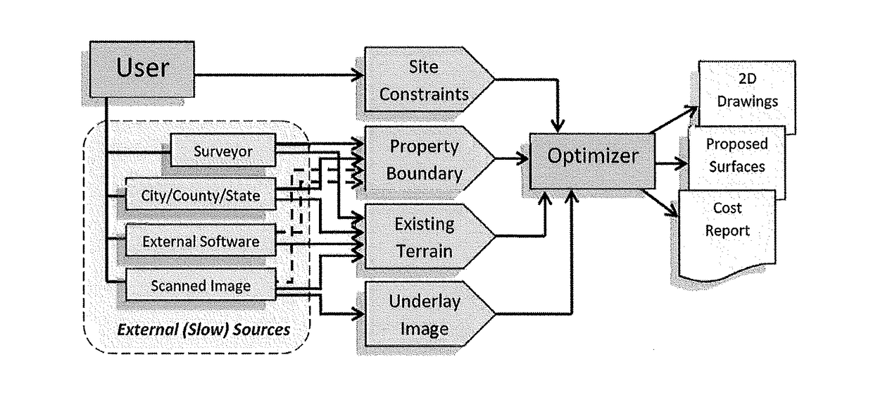
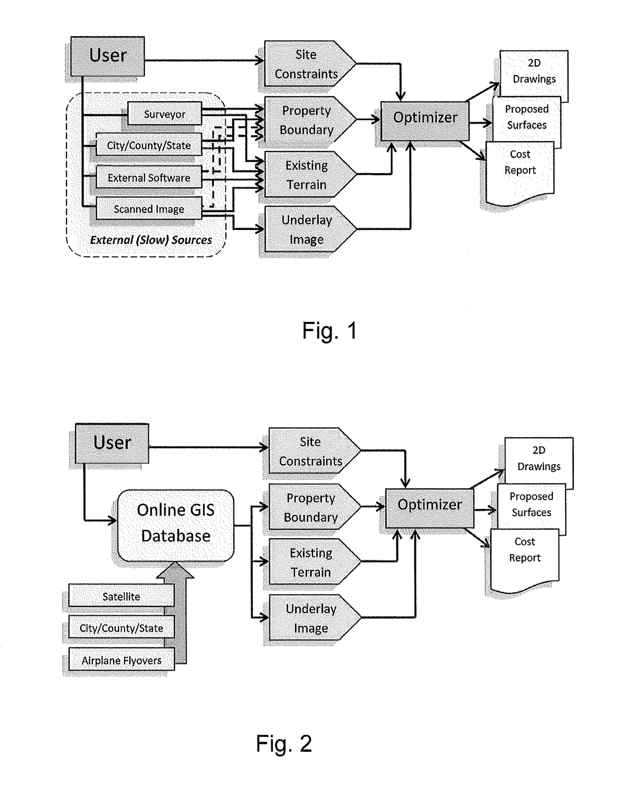
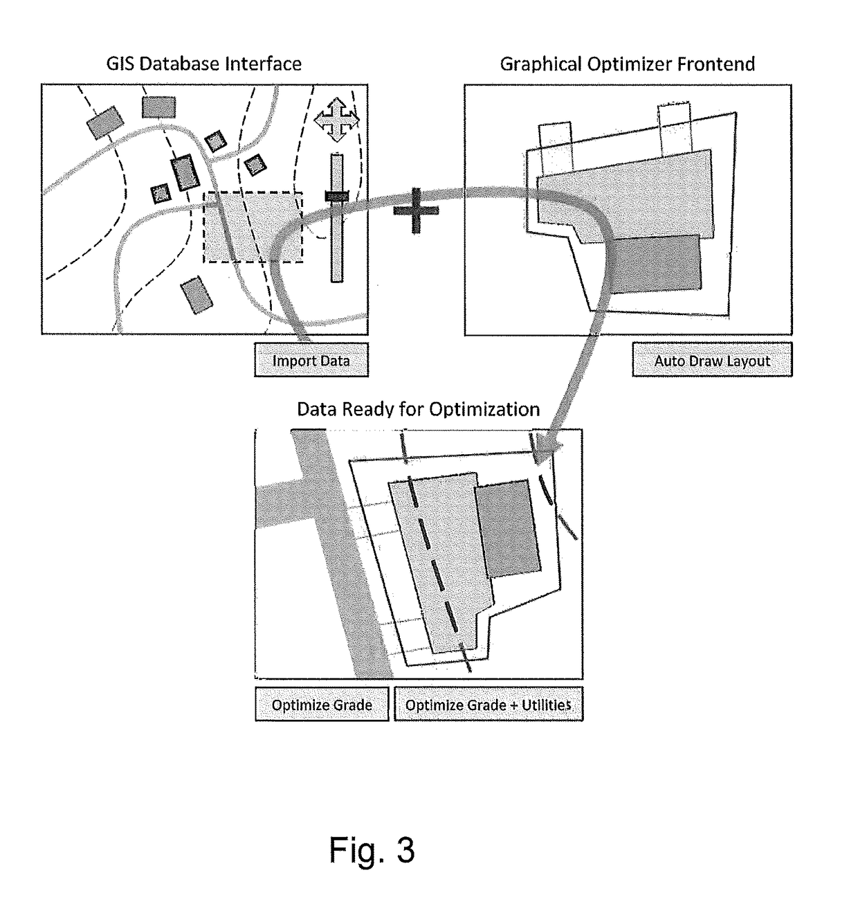
Computer-implemented land planning system and method with GIS integration
PatentActiveUS20170329875A1
Innovation
- A computer-implemented land planning system that utilizes GIS technology and heuristic problem-solving strategies, such as evolutionary algorithms, to generate optimized conceptual solutions for land development, reducing the time required to produce engineering drawings and cost estimates from months to hours, while minimizing initial investment and risk.

Location-based construction planning and scheduling system
PatentInactiveEP2013813A2
Innovation
- A location-based construction planning system that integrates critical path method (CPM) logic with a layered approach to identify parallel tasks and relationships, allowing for automated generation of construction activity schedules by associating tasks with specific locations and managing resources and risks.
Safety Standards and Regulations for Construction Technology
The integration of spatial computing platforms in construction planning necessitates comprehensive safety standards and regulatory frameworks to ensure worker protection and project integrity. Current safety regulations for construction technology are evolving to address the unique challenges posed by augmented reality, virtual reality, and mixed reality systems deployed on construction sites.
Occupational Safety and Health Administration (OSHA) guidelines are being adapted to encompass spatial computing applications, particularly focusing on hazard identification and risk assessment protocols. These regulations emphasize the importance of maintaining situational awareness while using immersive technologies, as workers must remain cognizant of physical hazards while interacting with digital overlays and virtual construction models.
International Organization for Standardization (ISO) has developed preliminary standards for spatial computing safety, including ISO 23053 for augmented reality applications in industrial environments. These standards address ergonomic considerations, visual fatigue prevention, and cognitive load management when using head-mounted displays and spatial tracking systems during extended construction planning sessions.
Regional building codes are incorporating requirements for spatial computing validation processes, mandating that virtual construction models undergo accuracy verification before implementation. The European Committee for Standardization (CEN) has established protocols for ensuring that spatial computing platforms maintain precise alignment with physical construction elements, preventing potential safety hazards arising from misaligned digital representations.
Emerging regulatory frameworks address data security and privacy concerns specific to spatial computing platforms, as these systems often capture detailed environmental data and worker movement patterns. Construction companies must comply with data protection regulations while implementing spatial computing solutions, ensuring that sensitive project information and personnel data remain secure throughout the planning and execution phases.
Professional liability standards are being updated to reflect the responsibilities of construction professionals utilizing spatial computing platforms. These regulations establish clear accountability frameworks for decisions made based on spatial computing analysis, defining the required qualifications and certification processes for operators of these advanced planning systems.
Integration Challenges with Existing Construction Workflows
The integration of spatial computing platforms into existing construction workflows presents multifaceted challenges that significantly impact adoption rates and operational efficiency. Traditional construction processes rely heavily on established methodologies, legacy software systems, and standardized documentation formats that have been refined over decades. When introducing spatial computing technologies, organizations encounter substantial resistance due to the fundamental shift required in operational paradigms.
Data interoperability emerges as a primary obstacle, as existing Building Information Modeling (BIM) systems, Computer-Aided Design (CAD) software, and project management platforms often utilize proprietary formats that are incompatible with spatial computing environments. The translation of two-dimensional drawings and three-dimensional models into immersive spatial representations requires sophisticated conversion algorithms and often results in data loss or accuracy degradation.
Workforce adaptation represents another critical challenge, as construction professionals must acquire new skill sets to effectively utilize spatial computing interfaces. The learning curve associated with gesture-based controls, voice commands, and mixed reality navigation differs substantially from traditional desktop-based workflows. This transition period can temporarily reduce productivity and requires comprehensive training programs.
Technical infrastructure limitations further complicate integration efforts. Many construction sites lack the robust wireless connectivity and computational resources necessary to support real-time spatial computing applications. The deployment of edge computing solutions and high-bandwidth networks requires significant capital investment and ongoing maintenance considerations.
Regulatory compliance and documentation standards pose additional barriers, as spatial computing outputs must align with established industry protocols and legal requirements. The translation of immersive visualizations into traditional deliverables for regulatory approval processes remains complex and time-consuming.
Synchronization between spatial computing platforms and existing project scheduling systems creates workflow disruptions. Real-time updates and collaborative features must seamlessly integrate with established communication channels and approval hierarchies to maintain project continuity and stakeholder engagement throughout the construction planning lifecycle.
Unlock deeper insights with PatSnap Eureka Quick Research — get a full tech report to explore trends and direct your research. Try now!
Generate Your Research Report Instantly with AI Agent
Supercharge your innovation with PatSnap Eureka AI Agent Platform!