

Spatial Computing Platforms in Smart City Planning
MAR 17, 20269 MIN READ
Generate Your Research Report Instantly with AI Agent
PatSnap Eureka helps you evaluate technical feasibility & market potential.
Spatial Computing Evolution in Urban Planning Context
Spatial computing in urban planning has undergone a remarkable transformation from rudimentary geographic information systems to sophisticated three-dimensional modeling and immersive visualization platforms. The evolution began in the 1960s with basic computer-aided design tools that digitized traditional paper-based planning processes. Early systems primarily focused on two-dimensional mapping and basic spatial analysis, providing planners with digital alternatives to manual drafting methods.
The 1980s marked a pivotal shift with the introduction of Geographic Information Systems (GIS), which revolutionized how planners analyzed spatial relationships and demographic patterns. These systems enabled layered data visualization and basic spatial queries, fundamentally changing urban analysis methodologies. The integration of satellite imagery and aerial photography during this period provided unprecedented access to real-time urban data.
The advent of three-dimensional modeling in the 1990s introduced volumetric analysis capabilities, allowing planners to visualize building heights, shadow patterns, and urban density distributions. Computer-aided design software evolved to support complex architectural modeling, enabling detailed neighborhood-scale planning and infrastructure design. This period also witnessed the emergence of simulation tools that could model traffic flows and population movements.
The 2000s brought web-based mapping platforms and the democratization of spatial data access. Online geographic services made spatial information accessible to broader stakeholder groups, facilitating public participation in planning processes. Real-time data integration became feasible, enabling dynamic urban monitoring and responsive planning strategies.
Contemporary spatial computing platforms leverage artificial intelligence, machine learning, and cloud computing to process vast urban datasets. These systems integrate Internet of Things sensors, mobile device data, and satellite imagery to create comprehensive digital twins of urban environments. Advanced visualization techniques, including virtual and augmented reality, enable immersive planning experiences that allow stakeholders to explore proposed developments before implementation.
Current platforms support predictive modeling, scenario planning, and real-time urban analytics, representing a fundamental shift from reactive to proactive urban planning methodologies. The integration of citizen-generated data and collaborative planning tools has transformed spatial computing from expert-only systems to inclusive platforms supporting community engagement and participatory planning processes.
Market Demand for Smart City Spatial Computing Solutions
The global smart city market is experiencing unprecedented growth driven by rapid urbanization, increasing population density, and the urgent need for sustainable urban development solutions. Urban areas worldwide face mounting challenges including traffic congestion, resource scarcity, environmental degradation, and infrastructure strain. These pressures create substantial demand for innovative spatial computing platforms that can optimize city planning processes through advanced data visualization, predictive modeling, and real-time analytics.
Government initiatives and policy frameworks significantly influence market demand for spatial computing solutions in urban planning. Many national and regional governments have established smart city development programs, allocating substantial budgets for digital transformation initiatives. These policies emphasize the integration of Internet of Things sensors, artificial intelligence, and spatial computing technologies to create more efficient, livable, and sustainable urban environments.
The market demonstrates strong demand across multiple application segments within smart city planning. Transportation planning represents a critical area where spatial computing platforms enable traffic flow optimization, public transit route planning, and autonomous vehicle infrastructure development. Urban infrastructure management benefits from three-dimensional modeling capabilities that support utility network planning, building information modeling integration, and disaster preparedness scenarios.
Environmental monitoring and sustainability planning constitute another high-demand segment. Spatial computing platforms facilitate air quality modeling, green space optimization, energy consumption analysis, and climate change adaptation strategies. These applications align with global sustainability goals and regulatory requirements for environmental impact assessment in urban development projects.
The market exhibits varying demand patterns across different geographic regions and city sizes. Megacities in developing economies show particularly strong demand for comprehensive spatial computing solutions to manage rapid urban expansion. Meanwhile, established urban centers in developed markets focus on optimization and modernization of existing infrastructure through advanced spatial analytics.
Technology adoption barriers influence market demand dynamics. While the potential benefits are widely recognized, concerns about implementation costs, data privacy, interoperability challenges, and workforce training requirements affect adoption rates. However, increasing availability of cloud-based platforms and software-as-a-service models are reducing entry barriers and expanding market accessibility for smaller municipalities and planning organizations.
Current State of Spatial Computing in Urban Development
Spatial computing platforms have emerged as transformative technologies in urban development, fundamentally reshaping how cities are planned, designed, and managed. These platforms integrate real-world physical spaces with digital information layers, creating immersive environments where urban planners can visualize, analyze, and interact with complex city data in three-dimensional contexts.
Current implementations primarily leverage augmented reality (AR), virtual reality (VR), and mixed reality (MR) technologies to create comprehensive digital twins of urban environments. Leading platforms such as Microsoft HoloLens-based solutions, Magic Leap applications, and specialized urban planning software like UrbanSim and CityScope enable planners to overlay demographic data, infrastructure information, and environmental metrics onto physical city models.
The technology has reached a maturity level where major metropolitan areas including Singapore, Barcelona, and Amsterdam have deployed spatial computing solutions for infrastructure planning and citizen engagement. These implementations demonstrate capabilities ranging from real-time traffic flow visualization to predictive modeling of urban growth patterns, allowing stakeholders to experience proposed developments before construction begins.
Integration challenges persist across different urban systems, particularly in data standardization and interoperability between legacy planning software and emerging spatial computing platforms. Current solutions often require significant computational resources and specialized hardware, limiting widespread adoption among smaller municipalities with constrained budgets.
Recent advances in cloud-based processing and 5G connectivity have enabled more accessible deployment models, with platforms now supporting collaborative planning sessions where multiple stakeholders can simultaneously interact with shared virtual city models. This collaborative approach has proven particularly effective in community engagement initiatives, allowing residents to visualize proposed changes and provide feedback in intuitive, immersive environments.
The convergence of Internet of Things (IoT) sensors, artificial intelligence, and spatial computing has created opportunities for real-time urban monitoring and adaptive planning responses. Cities are increasingly implementing these integrated systems to address complex challenges such as traffic congestion, energy efficiency, and sustainable development goals through data-driven spatial analysis and predictive modeling capabilities.
Existing Spatial Computing Platforms for Urban Planning
01 Virtual and augmented reality display systems
Spatial computing platforms utilize advanced display technologies including head-mounted displays, augmented reality glasses, and virtual reality headsets to present digital content in three-dimensional space. These systems incorporate optical components, projection systems, and transparent displays that allow users to view and interact with virtual objects overlaid on or integrated with the physical environment. The display systems support stereoscopic rendering, depth perception, and field-of-view optimization to create immersive spatial experiences.- Augmented Reality and Virtual Reality Integration: Spatial computing platforms integrate augmented reality (AR) and virtual reality (VR) technologies to create immersive experiences. These platforms utilize head-mounted displays, sensors, and tracking systems to overlay digital content onto the physical world or create fully virtual environments. The integration enables users to interact with three-dimensional digital objects in real-time, providing enhanced visualization and interaction capabilities for various applications including gaming, training, and design.
- Spatial Mapping and Environment Recognition: Advanced spatial computing platforms employ sophisticated mapping technologies to scan, recognize, and digitally reconstruct physical environments. These systems use depth sensors, cameras, and machine learning algorithms to create detailed three-dimensional maps of surroundings. The technology enables accurate placement of virtual objects in real space, obstacle detection, and navigation assistance. This capability is essential for applications requiring precise spatial awareness and environmental understanding.
- Multi-User Collaboration and Shared Experiences: Spatial computing platforms facilitate collaborative experiences where multiple users can interact within the same virtual or augmented space simultaneously. These systems synchronize user positions, gestures, and interactions across networked devices, enabling real-time collaboration regardless of physical location. The platforms support shared visualization of data, collaborative design work, and social interactions in mixed reality environments, enhancing teamwork and communication.
- Gesture and Motion Control Interfaces: Spatial computing platforms incorporate natural user interfaces that recognize and interpret human gestures, hand movements, and body motions as input commands. These systems utilize computer vision, depth sensing, and machine learning to track user movements without requiring physical controllers. The technology enables intuitive interaction with digital content through natural hand gestures, pointing, grasping, and body movements, creating more immersive and accessible user experiences.
- Spatial Audio and Acoustic Processing: Advanced spatial computing platforms integrate three-dimensional audio technologies that simulate realistic sound positioning and propagation in virtual and augmented environments. These systems process audio signals to create directional sound cues that correspond to the location of virtual objects or sources within the spatial environment. The technology enhances immersion by providing accurate acoustic feedback, enabling users to perceive sound as originating from specific locations in three-dimensional space.
02 Spatial tracking and positioning technologies
Accurate tracking of user position, orientation, and movement is fundamental to spatial computing platforms. These systems employ various sensing technologies including inertial measurement units, cameras, depth sensors, and external tracking systems to determine the precise location and orientation of users and objects in three-dimensional space. The tracking data enables proper alignment of virtual content with the physical world and supports natural interaction paradigms such as gesture recognition and spatial navigation.Expand Specific Solutions03 Spatial mapping and environment understanding
Spatial computing platforms incorporate technologies for scanning, mapping, and understanding the physical environment. These systems use depth sensing, computer vision, and machine learning algorithms to create detailed three-dimensional models of real-world spaces, identify surfaces, detect objects, and understand spatial relationships. The environmental data enables features such as occlusion handling, physics-based interactions, and persistent placement of virtual content in physical locations.Expand Specific Solutions04 Spatial interaction and input methods
These platforms provide various input modalities designed for three-dimensional interaction including hand tracking, gesture recognition, eye tracking, voice commands, and specialized controllers. The interaction systems interpret user actions in spatial context, enabling intuitive manipulation of virtual objects, navigation through three-dimensional interfaces, and natural communication within spatial computing environments. Multi-modal input fusion enhances accuracy and user experience.Expand Specific Solutions05 Spatial content rendering and processing architectures
The computational infrastructure of spatial computing platforms includes specialized processing architectures optimized for real-time rendering of three-dimensional content, spatial audio processing, and simultaneous execution of tracking, mapping, and interaction algorithms. These systems employ distributed computing approaches, edge processing, and cloud integration to handle the intensive computational requirements while maintaining low latency. Power management and thermal optimization are critical considerations for wearable spatial computing devices.Expand Specific Solutions
Leading Companies in Spatial Computing and Smart Cities
The spatial computing platforms market for smart city planning is experiencing rapid growth, driven by increasing urbanization and digital transformation initiatives. The industry is in an expansion phase with significant market potential, as cities worldwide seek integrated solutions for urban management and planning. Technology maturity varies considerably across market participants, with established tech giants like IBM, Salesforce, and Tencent demonstrating advanced capabilities in cloud computing and AI-driven platforms. Telecommunications leaders such as Telefonaktiebolaget LM Ericsson and Telecom Italia provide robust infrastructure foundations, while specialized IoT companies like Chengdu Qinchuan IoT Technology and Shenzhen Lumi United Technology offer targeted smart city solutions. Academic institutions including Southeast University, Tongji University, and New York University contribute essential research and development. The competitive landscape shows a convergence of traditional IT companies, telecommunications providers, and emerging IoT specialists, indicating a maturing ecosystem with diverse technological approaches and varying levels of commercial readiness.
Salesforce, Inc.
Technical Solution: Salesforce has developed Sustainability Cloud and IoT Cloud platforms that incorporate spatial computing capabilities for smart city planning. Their solution integrates geographic data with customer relationship management systems to help city governments track environmental metrics, manage citizen services, and optimize resource distribution across urban areas. The platform uses spatial analytics to correlate demographic data with service delivery patterns, enabling more efficient urban planning decisions. Salesforce's approach emphasizes citizen engagement through mobile applications that collect location-based feedback and service requests, creating a comprehensive spatial database for urban planning analysis.
Strengths: Excellent citizen engagement tools and strong CRM integration capabilities for government services. Weaknesses: Limited specialized urban planning features compared to dedicated GIS platforms and higher costs for comprehensive city-wide deployment.
Tencent Technology (Shenzhen) Co., Ltd.
Technical Solution: Tencent has developed WeCity, a smart city platform that leverages spatial computing through integration of geographic information systems, big data analytics, and cloud services. The platform processes spatial data from various urban sensors and mobile devices to create comprehensive city-wide intelligence systems. WeCity incorporates real-time location services, spatial analysis algorithms, and visualization tools that help urban planners understand population flow, traffic patterns, and resource utilization across different city zones. The platform supports multi-dimensional spatial data processing and provides APIs for third-party integration, enabling collaborative urban planning initiatives.
Strengths: Strong integration with existing Chinese urban infrastructure and extensive user data ecosystem. Weaknesses: Limited international deployment experience and potential data privacy concerns in global markets.
Core Patents in Spatial Computing for City Applications
Intelligent city planning system and method
PatentPendingCN111695773A
Innovation
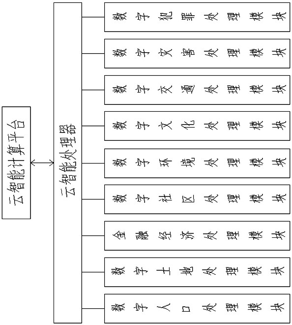
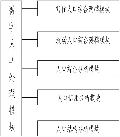
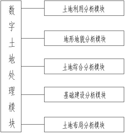
- It uses a cloud intelligent computing platform to integrate digital population, land, financial economy, community, environment, culture, transportation and disaster processing modules, realizes data interoperability and analysis through the cloud operating system, provides comprehensive planning solutions, simplifies the data upload and download process, and ensures Data security and integration capabilities.

Space-time information platform of smart city
PatentInactiveCN118152105A
Innovation
- Using the spatio-temporal scheduling model, host mapping based on grouping genetic algorithm, SAN virtualization based on storage routers, multi-objective virtualization monitoring technology and spatio-temporal distributed computing, a spatio-temporal information cloud platform framework is constructed. Through the spatio-temporal law constraint module, resource monitoring module, The spatiotemporal big data storage module and service chain combination module realize dynamic scheduling and effective allocation of resources.

Policy Framework for Smart City Technology Implementation
The implementation of spatial computing platforms in smart city planning requires a comprehensive policy framework that addresses regulatory, governance, and strategic considerations. Current policy landscapes across different jurisdictions show varying degrees of readiness for spatial computing integration, with some regions establishing dedicated smart city legislation while others rely on existing urban planning and technology regulations.
Data governance policies represent a critical foundation for spatial computing platforms, as these systems generate and process vast amounts of spatial and temporal data. Privacy protection frameworks must address the collection, storage, and utilization of location-based information while ensuring citizen consent and data sovereignty. Cross-border data transfer regulations particularly impact platforms that operate across multiple jurisdictions or utilize cloud-based processing capabilities.
Interoperability standards and technical specifications require policy-level coordination to ensure spatial computing platforms can integrate with existing urban infrastructure systems. Government agencies need clear guidelines for API standards, data formats, and system integration protocols. These policies should mandate open standards adoption while allowing flexibility for technological innovation and vendor diversity.
Procurement and public-private partnership frameworks must evolve to accommodate the unique characteristics of spatial computing platforms, including their reliance on real-time data processing and continuous system updates. Traditional procurement models often struggle with the dynamic nature of these technologies, necessitating new contractual approaches that balance innovation with accountability.
Ethical guidelines for spatial computing deployment in urban environments require policy attention, particularly regarding algorithmic transparency, bias prevention, and equitable access to technology benefits. Policies should establish clear principles for AI decision-making in urban planning contexts and ensure that spatial computing applications do not exacerbate existing social inequalities.
Professional certification and training requirements for urban planners and technology specialists working with spatial computing platforms need policy support to ensure adequate skill development. Educational institutions and professional bodies require guidance on curriculum development and competency standards for this emerging field.
Data Privacy and Security in Urban Spatial Computing
Data privacy and security represent critical challenges in urban spatial computing systems, where massive volumes of location-based data, citizen behavioral patterns, and infrastructure information are continuously collected and processed. The integration of IoT sensors, mobile devices, and surveillance systems in smart city environments creates unprecedented opportunities for data breaches and privacy violations, necessitating robust security frameworks to protect sensitive urban information.
The primary privacy concerns in spatial computing platforms stem from the granular nature of location data, which can reveal intimate details about citizens' daily routines, social connections, and personal preferences. Real-time tracking capabilities inherent in these systems pose risks of unauthorized surveillance and potential misuse by both malicious actors and governmental entities. Additionally, the aggregation of multi-source spatial data can enable re-identification of anonymized datasets, compromising individual privacy even when direct identifiers are removed.
Security vulnerabilities in urban spatial computing infrastructure present significant risks to city operations and citizen safety. Cyberattacks targeting spatial databases, sensor networks, or processing algorithms could disrupt critical services, manipulate urban planning decisions, or compromise emergency response systems. The distributed nature of spatial computing platforms, spanning multiple agencies and private partners, creates complex attack surfaces that require comprehensive security strategies.
Current approaches to addressing these challenges include implementing differential privacy techniques for spatial data anonymization, deploying blockchain-based systems for secure data sharing among stakeholders, and establishing federated learning frameworks that enable collaborative analysis without centralizing sensitive information. Advanced encryption methods, including homomorphic encryption, allow computation on encrypted spatial datasets while preserving data confidentiality.
Regulatory frameworks such as GDPR and emerging smart city data governance policies are driving the development of privacy-by-design principles in spatial computing platforms. These regulations mandate explicit consent mechanisms, data minimization practices, and transparent data processing procedures, fundamentally reshaping how urban spatial computing systems are architected and operated to ensure citizen trust and legal compliance.
Unlock deeper insights with PatSnap Eureka Quick Research — get a full tech report to explore trends and direct your research. Try now!
Generate Your Research Report Instantly with AI Agent
Supercharge your innovation with PatSnap Eureka AI Agent Platform!