
System and method for identifying and processing conflict key points of planning conditions of delivery plot
A technology for conflict resolution and planning, which is applied in the identification and handling of key points of conflicts in land transfer planning conditions, and in the field of land transfer links. It can solve problems such as conflicts, lack of planning condition management procedures, and long time consumption
Patent Information
- Authority / Receiving Office
- CN · China
- Patent Type
- Applications(China)
- Current Assignee / Owner
- Publication Date
- 2020-12-15
Smart Images
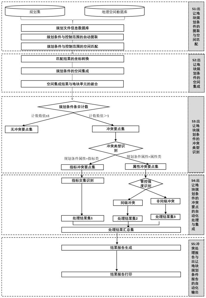
Figure 1 
Figure 2 
Figure 3
Abstract
Description
technical field
[0001] The invention relates to the transfer of land plots in the field of urban planning management, in particular to a system and method for identifying and processing conflicting points of planning conditions for transfer of land plots. Background technique
[0002] Land transfer planning conditions are the criteria for regulating and restricting the land use and construction activities of the construction unit based on the planning conditions such as the location, use nature, and development intensity of the transferred land proposed by the urban and rural planning administrative department in accordance with the relevant planning. It is state-owned land An integral part of the right-of-use transfer contract is an important way for various planning functional departments to implement urban planning.
[0003] The current verification and extraction of land transfer planning conditions is mainly through the urban and rural planning authorities of the city a...
Examples
Embodiment Construction
[0061] The technical solutions in the embodiments of the present invention will be clearly and completely described below in conjunction with the accompanying drawings in the embodiments of the present invention. Apparently, the described embodiments are only implementation examples of the present invention, not all implementation examples.
[0062] A system for identifying and processing conflict points of planning conditions for transfer of land, including a data collection module, a planning condition spatialization module, a conflict point identification module, a conflict point coordination processing module, and a report output module.
[0063] The data acquisition module is used to obtain planning conditions and control ranges in various planning documents, and spatially match the planning conditions and control ranges.
[0064] The planning condition spatialization module is used to perform spatial information registration and coordinate transformation on the matching ...