Exploring Dolby Vision’s Impact on Aerial Photography
JUL 30, 20259 MIN READ
Generate Your Research Report Instantly with AI Agent
Patsnap Eureka helps you evaluate technical feasibility & market potential.
Dolby Vision in Aerial Imaging: Background and Objectives
Dolby Vision, a cutting-edge High Dynamic Range (HDR) technology, has revolutionized the visual experience across various media platforms. As it extends its reach into aerial photography, it promises to transform the way we capture and perceive aerial imagery. This technological advancement comes at a time when aerial photography is experiencing unprecedented growth, driven by the proliferation of drones and the increasing demand for high-quality aerial content in industries such as real estate, cinematography, and environmental monitoring.
The evolution of Dolby Vision technology traces back to its roots in cinema and home entertainment, where it has set new standards for image quality. Its application in aerial imaging represents a natural progression, addressing the unique challenges posed by the dynamic lighting conditions and vast color ranges encountered in aerial photography. The technology's ability to capture and display a wider range of colors and brightness levels aligns perfectly with the needs of aerial photographers who often struggle with high-contrast scenes and rapidly changing light conditions.
The primary objective of integrating Dolby Vision into aerial photography is to enhance the overall image quality and fidelity of aerial captures. This includes improving color accuracy, expanding the dynamic range, and preserving details in both highlights and shadows. By doing so, it aims to provide a more immersive and true-to-life representation of aerial scenes, bridging the gap between what the human eye perceives and what traditional imaging technologies can capture.
Furthermore, the adoption of Dolby Vision in aerial imaging seeks to address several technical challenges inherent to aerial photography. These include managing extreme contrast ratios often encountered in aerial scenes, mitigating the effects of atmospheric haze, and maintaining color accuracy across varying altitudes and weather conditions. The technology's advanced algorithms and metadata-driven approach offer promising solutions to these long-standing issues.
As we explore the impact of Dolby Vision on aerial photography, it is crucial to consider the broader implications for various industries. The enhanced visual quality could lead to more accurate environmental assessments, more engaging real estate presentations, and more spectacular cinematographic experiences. Additionally, the technology has the potential to improve the effectiveness of aerial surveillance and reconnaissance missions, offering clearer and more detailed imagery for analysis.
In the context of technological trends, the integration of Dolby Vision into aerial imaging aligns with the broader movement towards higher resolution, greater color depth, and improved dynamic range in digital imaging. This trend is driven by advancements in sensor technology, processing power, and display capabilities, all of which contribute to the feasibility and effectiveness of implementing Dolby Vision in aerial photography systems.
Market Demand for Enhanced Aerial Photography
The aerial photography market has witnessed a significant surge in demand for enhanced image quality and color accuracy, driven by various industries' growing reliance on high-quality aerial imagery. This demand stems from sectors such as real estate, agriculture, environmental monitoring, and urban planning, where precise visual data is crucial for decision-making processes.
In the real estate industry, there's an increasing need for immersive and lifelike aerial footage of properties. Potential buyers and investors are seeking more detailed and visually appealing representations of properties, including their surroundings and landscapes. This has led to a rise in the use of high-dynamic-range (HDR) imaging techniques in aerial photography, where Dolby Vision technology can play a transformative role.
The agriculture sector has also shown a strong interest in advanced aerial imaging technologies. Farmers and agronomists require highly detailed and color-accurate images to monitor crop health, detect diseases, and optimize resource allocation. The enhanced color range and contrast offered by technologies like Dolby Vision can significantly improve the accuracy of crop analysis and yield predictions.
Environmental monitoring and conservation efforts have created another substantial market for enhanced aerial photography. Organizations involved in wildlife tracking, forest management, and climate change studies demand images with superior color fidelity and detail. These requirements align well with the capabilities of advanced HDR technologies, potentially opening new avenues for Dolby Vision's application in this field.
Urban planners and infrastructure developers represent another key market segment driving the demand for improved aerial imagery. They require highly detailed and accurate visual data for city modeling, traffic analysis, and infrastructure planning. The enhanced depth and color accuracy provided by advanced imaging technologies can greatly assist in creating more precise urban models and simulations.
The film and entertainment industry has also shown increasing interest in incorporating high-quality aerial footage in productions. Documentaries, nature shows, and even feature films are leveraging aerial photography to capture stunning landscapes and cityscapes. The demand for content that can fully utilize the capabilities of HDR displays is growing, making technologies like Dolby Vision particularly relevant in this context.
As consumer devices increasingly support HDR content, there's a growing expectation for higher quality visual experiences across all platforms. This trend is likely to further drive the demand for enhanced aerial photography, as content creators and distributors seek to meet these evolving consumer expectations.
Current Challenges in Aerial Imaging Technology
Aerial imaging technology has made significant strides in recent years, yet several challenges persist in capturing high-quality aerial photographs. One of the primary obstacles is the dynamic range limitation of current camera sensors. Aerial scenes often encompass a wide range of light intensities, from bright sunlit areas to deep shadows, which exceed the capabilities of standard sensors. This results in images with blown-out highlights or lost details in darker regions.
Another significant challenge is motion blur, particularly in low-light conditions or when capturing fast-moving subjects. The constant movement of aerial platforms, combined with potentially long exposure times, can lead to reduced image sharpness and loss of fine details. This issue is exacerbated by the need for higher shutter speeds to counteract motion, which in turn requires increased light sensitivity or wider apertures, potentially compromising image quality.
Color accuracy and consistency pose additional challenges in aerial photography. Atmospheric conditions, varying altitudes, and changing light conditions throughout the day can significantly affect color rendition. This makes it difficult to achieve consistent and accurate color representation across different shots or throughout extended filming sessions.
Image stabilization remains a critical issue, especially for video capture. Despite advancements in gimbal technology and electronic image stabilization, the inherent instability of aerial platforms continues to impact image quality. Vibrations from aircraft engines or drone propellers can introduce micro-jitters that degrade overall image sharpness and clarity.
Weather and environmental factors present ongoing challenges. Moisture, dust, and temperature variations can affect equipment performance and image quality. Lens fogging, sensor dust accumulation, and thermal expansion of camera components can all lead to degraded image quality or equipment malfunction during aerial operations.
Data management and transmission pose significant logistical challenges. The high-resolution images and videos captured during aerial missions generate massive amounts of data. Efficiently storing, transferring, and processing this data, especially in real-time applications, remains a bottleneck in many aerial imaging workflows.
Lastly, regulatory constraints and privacy concerns continue to impact aerial imaging technology. Restrictions on flight altitudes, no-fly zones, and requirements for obtaining permissions can limit the scope and flexibility of aerial photography operations. Balancing the need for high-quality aerial imagery with privacy and security considerations remains an ongoing challenge for the industry.
Existing Dolby Vision Implementation in Aerial Systems
01 High Dynamic Range (HDR) Technology
Dolby Vision utilizes HDR technology to enhance image quality by expanding the range of both contrast and color. This results in brighter highlights, deeper blacks, and a wider color gamut, providing a more lifelike and immersive viewing experience.- High Dynamic Range (HDR) Technology: Dolby Vision utilizes HDR technology to enhance image quality by expanding the range of both contrast and color. This results in brighter highlights, deeper blacks, and a wider color gamut, providing a more lifelike and immersive viewing experience.
- Dynamic Metadata Processing: Dolby Vision employs dynamic metadata processing to optimize image quality on a scene-by-scene or even frame-by-frame basis. This allows for precise control over brightness, color, and contrast, ensuring that each image is displayed at its best possible quality.
- Color Grading and Mapping: Advanced color grading and mapping techniques are used in Dolby Vision to accurately reproduce colors across different display devices. This ensures consistent color representation and maintains the creator's artistic intent, regardless of the viewing device's capabilities.
- Display Calibration and Optimization: Dolby Vision incorporates display calibration and optimization algorithms to adapt content to the specific characteristics of individual displays. This ensures that the image quality is optimized for each unique viewing environment and display technology.
- Content Creation and Mastering Tools: Specialized content creation and mastering tools are developed for Dolby Vision, allowing filmmakers and content creators to produce high-quality HDR content. These tools enable precise control over image parameters during the production process, ensuring the highest possible image quality in the final product.
02 Dynamic Metadata Processing
Dolby Vision employs dynamic metadata processing to optimize image quality on a scene-by-scene or frame-by-frame basis. This allows for precise control over brightness, contrast, and color, ensuring that each image is displayed at its best possible quality.Expand Specific Solutions03 Color Mapping and Calibration
Advanced color mapping and calibration techniques are used in Dolby Vision to ensure accurate color reproduction across different display devices. This includes methods for adapting content to the specific capabilities of each display, maintaining color consistency and image fidelity.Expand Specific Solutions04 Display Device Optimization
Dolby Vision technology includes features for optimizing image quality based on the specific characteristics of the display device. This involves adjusting parameters such as peak brightness, black levels, and color gamut to match the capabilities of the screen, ensuring optimal performance across various display technologies.Expand Specific Solutions05 Content Creation and Mastering Tools
Dolby Vision provides a suite of content creation and mastering tools that enable filmmakers and content producers to create and deliver high-quality HDR content. These tools allow for precise control over image parameters during the production process, ensuring that the creator's vision is accurately preserved and displayed.Expand Specific Solutions
Key Players in Dolby Vision and Aerial Imaging
The aerial photography market, particularly with Dolby Vision technology, is in a growth phase characterized by increasing demand and technological advancements. The market size is expanding due to rising applications in various sectors, including entertainment, real estate, and surveillance. While the technology is maturing, it's not yet fully mature, with ongoing innovations from key players. Companies like Microsoft, Sony, and DJI are at the forefront, leveraging their expertise in imaging and drone technology. Other significant contributors include Northrop Grumman and Boeing in the aerospace sector, and specialized firms like Nearmap and Pictometry International in aerial imaging. The competitive landscape is diverse, with tech giants, aerospace companies, and niche players all vying for market share and technological leadership.
SZ DJI Technology Co., Ltd.
Technical Solution: DJI has integrated Dolby Vision HDR technology into their aerial photography drones, particularly in the Mavic 3 series. This integration allows for capturing and processing high dynamic range (HDR) footage directly in-camera, resulting in more vibrant colors and enhanced contrast in aerial shots. The drones utilize advanced image processing algorithms to map the wide color gamut and high bit depth of Dolby Vision to the drone's camera sensors, enabling the capture of a broader range of colors and luminance levels. This technology also supports real-time HDR monitoring on compatible displays, allowing photographers to preview the enhanced image quality during flight[1][3].
Strengths: Improved color accuracy and dynamic range in aerial footage, real-time HDR monitoring. Weaknesses: Requires Dolby Vision compatible displays for full benefit, potentially higher processing power requirements.
Sony Group Corp.
Technical Solution: Sony has incorporated Dolby Vision technology into its professional-grade cameras and imaging systems used in aerial photography. Their approach focuses on capturing wide color gamut and high dynamic range data using advanced CMOS sensors with high bit depth. Sony's implementation includes specialized image processing engines that can handle the complex Dolby Vision metadata, ensuring accurate color grading and tone mapping. This technology is particularly beneficial in challenging lighting conditions often encountered in aerial photography, such as bright skies contrasting with darker ground features. Sony's systems also support seamless integration with post-production workflows that maintain the Dolby Vision data throughout the editing process[2][5].
Strengths: High-quality image capture in challenging lighting conditions, seamless integration with professional post-production workflows. Weaknesses: Higher cost of equipment, may require specialized training for optimal use.
Core Innovations of Dolby Vision for Aerial Use
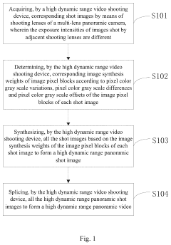
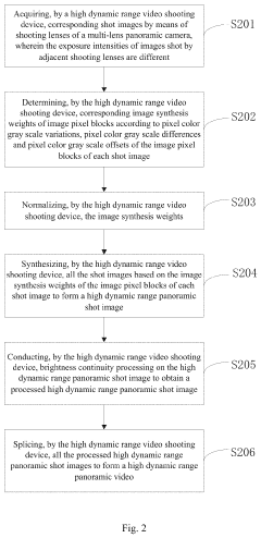
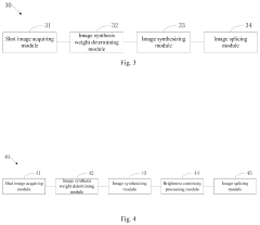
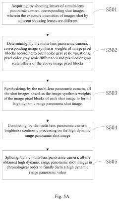
High dynamic range video capturing method and capturing device
PatentActiveUS20200344399A1
Innovation
- A high dynamic range video shooting method and device utilizing a multi-lens panoramic camera with different exposure intensities for adjacent lenses, determining image synthesis weights based on pixel color gray scale variations, differences, and offsets, and conducting brightness continuity processing to synthesize accurate HDR panoramic videos of moving objects.
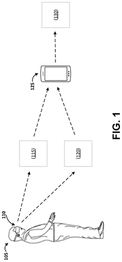
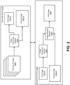
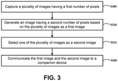
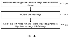
High dynamic range (HDR) photography with split compute on a wearable device
PatentPendingUS20250227383A1
Innovation
- A split compute approach where wearable devices perform initial image processing at a reduced resolution, aligning and merging images, while a companion device handles tone mapping and merging using machine learned models to generate HDR images.
Environmental Factors Affecting Aerial HDR Imaging
Environmental factors play a crucial role in the quality and effectiveness of aerial HDR imaging, particularly when utilizing advanced technologies like Dolby Vision. The dynamic nature of aerial photography introduces a unique set of challenges that must be carefully considered and addressed to achieve optimal results.
Atmospheric conditions significantly impact the capture of high dynamic range images from aerial platforms. Factors such as humidity, air pollution, and particulate matter can scatter light and reduce image clarity. This scattering effect is particularly pronounced at higher altitudes, where the atmosphere becomes thinner and more susceptible to light diffraction. Additionally, temperature variations can cause thermal distortions, affecting the accuracy of color reproduction and contrast in HDR imagery.
Lighting conditions present another critical environmental factor in aerial HDR imaging. The angle and intensity of sunlight change dramatically throughout the day, influencing shadow formation and overall scene contrast. During the "golden hours" of sunrise and sunset, the warm, directional light can enhance the depth and dimensionality of aerial photographs. However, these periods also introduce challenges in balancing exposure across the dynamic range, requiring careful calibration of HDR imaging systems.
Weather patterns significantly affect the feasibility and quality of aerial HDR photography. Cloud cover can create uneven lighting conditions across a landscape, leading to complex exposure scenarios that test the limits of HDR technology. Conversely, clear skies may result in harsh contrasts between sunlit and shadowed areas, pushing the dynamic range capabilities of imaging systems to their extremes.
Wind and turbulence pose unique challenges to aerial HDR imaging, particularly for drone-based photography. These factors can introduce motion blur and instability, compromising the sharpness and alignment of multiple exposures necessary for HDR composition. Advanced stabilization systems and intelligent exposure bracketing techniques are essential to mitigate these effects and ensure consistent image quality.
The altitude at which aerial photography is conducted also influences HDR imaging outcomes. Higher altitudes generally offer clearer atmospheric conditions but may reduce the perceived detail of ground-level features. Lower altitudes provide greater detail but are more susceptible to atmospheric disturbances and lighting variations. Finding the optimal balance between altitude, image resolution, and environmental factors is crucial for maximizing the benefits of HDR technology in aerial photography.
Seasonal changes introduce another layer of complexity to aerial HDR imaging. Variations in vegetation, snow cover, and natural light characteristics across different seasons can dramatically alter the dynamic range requirements for effective imaging. Adapting HDR capture and processing techniques to these seasonal shifts is essential for maintaining consistent image quality throughout the year.
Data Management and Processing in Dolby Vision Aerial Imagery
The integration of Dolby Vision technology into aerial photography has revolutionized data management and processing workflows. This advanced HDR imaging system requires specialized handling of the vast amounts of data generated during aerial surveys and photogrammetry missions.
Dolby Vision's wide color gamut and high dynamic range capabilities result in significantly larger file sizes compared to traditional imaging formats. This increase in data volume necessitates robust storage solutions and efficient data transfer mechanisms. Cloud-based storage platforms have emerged as a popular choice for managing Dolby Vision aerial imagery, offering scalability and accessibility for distributed teams.
Processing Dolby Vision aerial imagery demands powerful computing resources to handle the increased bit depth and color information. GPU acceleration has become crucial in processing workflows, enabling faster rendering and real-time visualization of high-fidelity Dolby Vision content. Specialized software tools have been developed to support Dolby Vision's unique color mapping and metadata requirements, ensuring accurate color grading and preservation of the expanded dynamic range throughout the processing pipeline.
Data compression techniques play a vital role in managing Dolby Vision aerial imagery. Lossless compression algorithms have been optimized to maintain the integrity of the high dynamic range data while reducing file sizes for more efficient storage and transmission. However, balancing compression ratios with image quality remains a challenge, particularly for applications requiring maximum fidelity.
The integration of Dolby Vision into photogrammetry software has enabled the creation of highly detailed 3D models with enhanced color accuracy and depth perception. This has proven particularly valuable in applications such as urban planning, environmental monitoring, and cultural heritage preservation, where precise color reproduction and subtle tonal variations are critical.
Data security and version control have become increasingly important in managing Dolby Vision aerial imagery. Encryption protocols and secure data transfer methods are employed to protect sensitive information, while advanced version control systems help manage multiple iterations of processed imagery and ensure collaborative workflows remain efficient.
As the adoption of Dolby Vision in aerial photography continues to grow, standardization efforts are underway to establish best practices for data management and processing. These initiatives aim to streamline workflows, improve interoperability between different software platforms, and ensure consistent quality across the industry.
Unlock deeper insights with Patsnap Eureka Quick Research — get a full tech report to explore trends and direct your research. Try now!
Generate Your Research Report Instantly with AI Agent
Supercharge your innovation with Patsnap Eureka AI Agent Platform!