

Fixed Satellite Services for Advanced Remote Sensing Projects
MAR 18, 20268 MIN READ
Generate Your Research Report Instantly with AI Agent
PatSnap Eureka helps you evaluate technical feasibility & market potential.
FSS Remote Sensing Background and Objectives
Fixed Satellite Services have emerged as a cornerstone technology for advanced remote sensing applications, representing a critical evolution in Earth observation capabilities. The historical development of FSS for remote sensing traces back to the early 1970s with the launch of Landsat-1, which established the foundation for systematic Earth monitoring from space. Over the subsequent decades, technological advancements in satellite platforms, sensor technologies, and data transmission systems have transformed FSS into sophisticated multi-mission platforms capable of supporting diverse remote sensing requirements.
The evolution of FSS remote sensing has been characterized by significant improvements in spatial, temporal, and spectral resolution capabilities. Early systems provided basic multispectral imaging with moderate resolution, while contemporary FSS platforms integrate hyperspectral sensors, synthetic aperture radar, and thermal infrared instruments. This technological progression has enabled applications ranging from precision agriculture and environmental monitoring to disaster response and climate change research.
Current technological trends indicate a shift toward more integrated and autonomous FSS architectures. The integration of artificial intelligence and machine learning algorithms directly into satellite platforms enables real-time data processing and decision-making capabilities. Additionally, the development of software-defined satellites allows for dynamic reconfiguration of sensing parameters and mission objectives, maximizing the utility of FSS investments across multiple user communities.
The primary technical objectives for advanced FSS remote sensing projects center on achieving enhanced data quality, reduced latency, and improved accessibility. Spatial resolution targets have progressed toward sub-meter capabilities for commercial applications, while temporal revisit requirements demand constellation architectures capable of daily or near-real-time coverage. Spectral resolution objectives focus on expanding the number of discrete bands and improving signal-to-noise ratios to enable more precise material identification and quantitative analysis.
Operational objectives emphasize the development of robust, reliable systems capable of sustained performance in the challenging space environment. This includes radiation-hardened electronics, advanced thermal management systems, and redundant subsystem architectures. Furthermore, the integration of inter-satellite communication links and ground segment automation aims to create seamless data flow from acquisition to end-user delivery, reducing operational complexity and costs while improving service reliability for critical remote sensing applications.
Market Demand for Advanced Satellite Remote Sensing
The global satellite remote sensing market has experienced unprecedented growth driven by increasing demand across multiple sectors including agriculture, environmental monitoring, defense, urban planning, and disaster management. Government agencies worldwide are investing heavily in advanced remote sensing capabilities to support national security initiatives, climate change monitoring, and resource management programs. The agricultural sector represents one of the fastest-growing segments, with precision farming applications requiring high-resolution imagery and frequent revisit capabilities to optimize crop yields and monitor field conditions.
Commercial enterprises are increasingly adopting satellite-based remote sensing solutions for infrastructure monitoring, supply chain optimization, and risk assessment. The insurance industry particularly values these services for catastrophe modeling and claims verification, while energy companies utilize satellite data for pipeline monitoring and exploration activities. Mining and forestry sectors depend on regular satellite observations for resource assessment and environmental compliance monitoring.
The demand for real-time or near-real-time data delivery has intensified significantly, pushing the boundaries of traditional satellite communication systems. Fixed Satellite Services play a crucial role in meeting these requirements by providing reliable, high-bandwidth communication links between remote sensing satellites and ground stations. This capability enables rapid data transmission and processing, which is essential for time-sensitive applications such as emergency response and military reconnaissance.
Emerging applications in smart city development and Internet of Things integration are creating new market opportunities for advanced satellite remote sensing services. Urban planners require detailed, frequently updated imagery to monitor city growth patterns and infrastructure development. Environmental agencies demand continuous monitoring capabilities for pollution tracking, deforestation detection, and biodiversity conservation efforts.
The increasing availability of small satellite constellations has democratized access to satellite imagery, expanding the customer base beyond traditional government and large enterprise users. Small and medium-sized businesses can now afford satellite-based monitoring solutions for their specific operational needs. This market expansion has created demand for more flexible and cost-effective Fixed Satellite Services that can support diverse user requirements while maintaining high data quality and reliability standards.
Current FSS Technology Status and Challenges
Fixed Satellite Services technology for advanced remote sensing has reached a mature operational stage, with current systems operating primarily in C-band, Ku-band, and Ka-band frequencies. Modern FSS constellations provide continuous coverage through geostationary satellites positioned at strategic orbital slots, enabling real-time data transmission from remote sensing platforms to ground stations. The technology supports data rates ranging from several Mbps to multi-Gbps, depending on the frequency band and satellite configuration.
Current FSS infrastructure demonstrates robust performance in supporting various remote sensing applications, including Earth observation satellites, weather monitoring systems, and environmental surveillance platforms. The technology has evolved to incorporate advanced modulation schemes, adaptive coding, and spot beam technologies that enhance spectral efficiency and coverage flexibility. Multiple satellite operators maintain extensive FSS networks that serve the remote sensing community globally.
Despite technological maturity, FSS faces significant spectrum congestion challenges, particularly in traditional C-band and Ku-band frequencies. The increasing demand from remote sensing missions, combined with terrestrial 5G deployment pressures, has created intense competition for available spectrum resources. Rain fade and atmospheric attenuation continue to impact signal quality, especially for higher frequency Ka-band operations, requiring sophisticated mitigation techniques and redundancy planning.
Latency remains a fundamental constraint for geostationary FSS systems, with typical round-trip delays of 500-600 milliseconds affecting real-time applications. This limitation becomes critical for time-sensitive remote sensing operations requiring immediate data processing and response capabilities. Additionally, the growing space debris environment poses increasing risks to satellite operations and long-term service reliability.
Cost considerations present ongoing challenges, as FSS capacity pricing remains relatively high compared to terrestrial alternatives. The economics of dedicated satellite capacity for remote sensing projects often require careful optimization of data transmission schedules and compression techniques. Furthermore, the limited flexibility of traditional FSS systems in adapting to dynamic mission requirements constrains operational efficiency for advanced remote sensing applications requiring variable bandwidth and coverage patterns.
Current FSS Solutions for Remote Sensing Applications
01 Frequency band allocation and interference management in FSS
Fixed Satellite Services require careful management of frequency bands to avoid interference with other communication systems. Techniques include dynamic frequency allocation, interference mitigation algorithms, and coordination between different satellite operators. Methods involve monitoring spectrum usage, implementing guard bands, and utilizing advanced filtering techniques to ensure reliable satellite communication while minimizing cross-interference with terrestrial and other satellite services.- Frequency band allocation and interference management in FSS: Fixed satellite services require careful management of frequency bands to avoid interference with other communication systems. Techniques include dynamic frequency allocation, interference detection and mitigation methods, and coordination between different satellite operators. Advanced filtering and signal processing methods are employed to ensure reliable communication channels while minimizing cross-interference with terrestrial and other satellite services.
- Satellite beam forming and coverage optimization: Technologies for optimizing satellite beam patterns and coverage areas to improve service quality and capacity in fixed satellite services. This includes adaptive beam forming techniques, multi-beam antenna systems, and methods for dynamically adjusting coverage areas based on traffic demand. These approaches enable more efficient use of satellite resources and improved signal quality for ground stations.
- Ground station antenna systems and tracking mechanisms: Ground station equipment and antenna systems designed for fixed satellite service applications, including tracking mechanisms to maintain alignment with satellites. Technologies cover antenna design, positioning systems, automatic tracking algorithms, and stabilization methods to ensure continuous and reliable communication links. These systems are essential for maintaining high-quality connections in various environmental conditions.
- Modulation and coding schemes for satellite links: Advanced modulation and error correction coding techniques specifically designed for fixed satellite service communications to maximize data throughput and reliability. These include adaptive coding and modulation schemes that adjust to varying link conditions, forward error correction methods, and bandwidth-efficient modulation formats. Such techniques are crucial for optimizing spectral efficiency and maintaining service quality under different atmospheric and operational conditions.
- Network architecture and resource management for FSS: System architectures and resource allocation methods for managing fixed satellite service networks, including bandwidth allocation, traffic routing, and quality of service provisioning. Technologies encompass network management protocols, dynamic resource allocation algorithms, and methods for integrating satellite links with terrestrial networks. These solutions enable efficient operation of satellite communication systems and seamless service delivery to end users.
02 Satellite beam forming and coverage optimization
Advanced beam forming technologies enable satellites to create multiple spot beams for targeted coverage areas. This includes adaptive beam shaping, multi-beam antenna systems, and dynamic beam steering capabilities. These techniques allow for efficient frequency reuse, increased capacity, and improved signal quality in specific geographic regions while optimizing power consumption and bandwidth utilization across the satellite footprint.Expand Specific Solutions03 Ground station architecture and signal processing
Ground station systems for fixed satellite services incorporate sophisticated signal processing capabilities, including modulation and demodulation techniques, error correction coding, and adaptive equalization. The architecture includes antenna tracking systems, uplink and downlink processing chains, and network management interfaces. These systems ensure reliable communication links between terrestrial networks and satellite platforms while maintaining quality of service requirements.Expand Specific Solutions04 Bandwidth management and traffic optimization
Efficient bandwidth utilization in fixed satellite services involves dynamic resource allocation, traffic prioritization, and quality of service management. Techniques include statistical multiplexing, bandwidth-on-demand allocation, and congestion control mechanisms. These methods enable optimal distribution of satellite capacity among multiple users and applications while maintaining service level agreements and maximizing overall system throughput.Expand Specific Solutions05 Satellite network integration and interoperability
Integration of fixed satellite services with terrestrial networks requires standardized protocols, gateway systems, and seamless handover mechanisms. This includes hybrid network architectures that combine satellite and terrestrial links, protocol conversion systems, and network management platforms. Solutions enable end-to-end connectivity, support for various service types, and interoperability between different satellite systems and ground-based infrastructure.Expand Specific Solutions
Major Players in FSS Remote Sensing Industry
The fixed satellite services market for advanced remote sensing is experiencing rapid growth, driven by increasing demand for high-resolution Earth observation data across commercial and government sectors. The industry is in a mature expansion phase, with market size reaching billions annually and projected continued growth. Technology maturity varies significantly across key players, with established aerospace giants like Boeing, Airbus Operations, and Sony Group demonstrating advanced capabilities in satellite manufacturing and sensor technologies. Chinese institutions including Beijing Institute of Spacecraft System Engineering, Chang Guang Satellite Technology, and Shanghai Institute of Satellite Engineering represent emerging competitive forces with substantial government backing. Research universities such as Wuhan University, National University of Defense Technology, and Bundeswehr University Munich contribute cutting-edge innovations in remote sensing algorithms and satellite systems. The competitive landscape features a mix of traditional aerospace contractors, specialized satellite companies like ViaSat, technology firms including Qualcomm and Nokia Technologies, and emerging players from Asia-Pacific regions, creating a dynamic ecosystem with varying levels of technological sophistication and market penetration.
Chang Guang Satellite Technology Co., Ltd.
Technical Solution: Chang Guang Satellite has developed the Jilin-1 constellation for high-resolution Earth observation, providing sub-meter resolution imagery for remote sensing applications. Their technical solution integrates advanced CCD and CMOS sensors with Ka-band communication systems for real-time data transmission. The company operates over 100 satellites in low Earth orbit, offering revisit times as short as 10 minutes for critical areas. Their satellites feature agile attitude control systems enabling rapid target acquisition and multi-angle imaging capabilities for enhanced remote sensing accuracy.
Strengths: Large operational constellation with frequent revisit capabilities and high-resolution imaging. Weaknesses: Limited to optical sensors, weather-dependent operations.
Aerospace Information Research Institute
Technical Solution: The Aerospace Information Research Institute develops integrated remote sensing solutions combining multiple satellite platforms with advanced data processing algorithms. Their technical approach utilizes hyperspectral imaging, SAR, and LiDAR technologies for comprehensive Earth observation. The institute operates ground receiving stations with real-time processing capabilities, supporting applications in environmental monitoring, disaster response, and resource management. Their systems feature automated target recognition and change detection algorithms, enabling rapid analysis of large-scale remote sensing datasets for scientific research applications.
Strengths: Advanced multi-sensor integration capabilities with strong research foundation and comprehensive data processing systems. Weaknesses: Limited commercial availability and primarily research-focused operations.
Core FSS Technologies for Advanced Remote Sensing
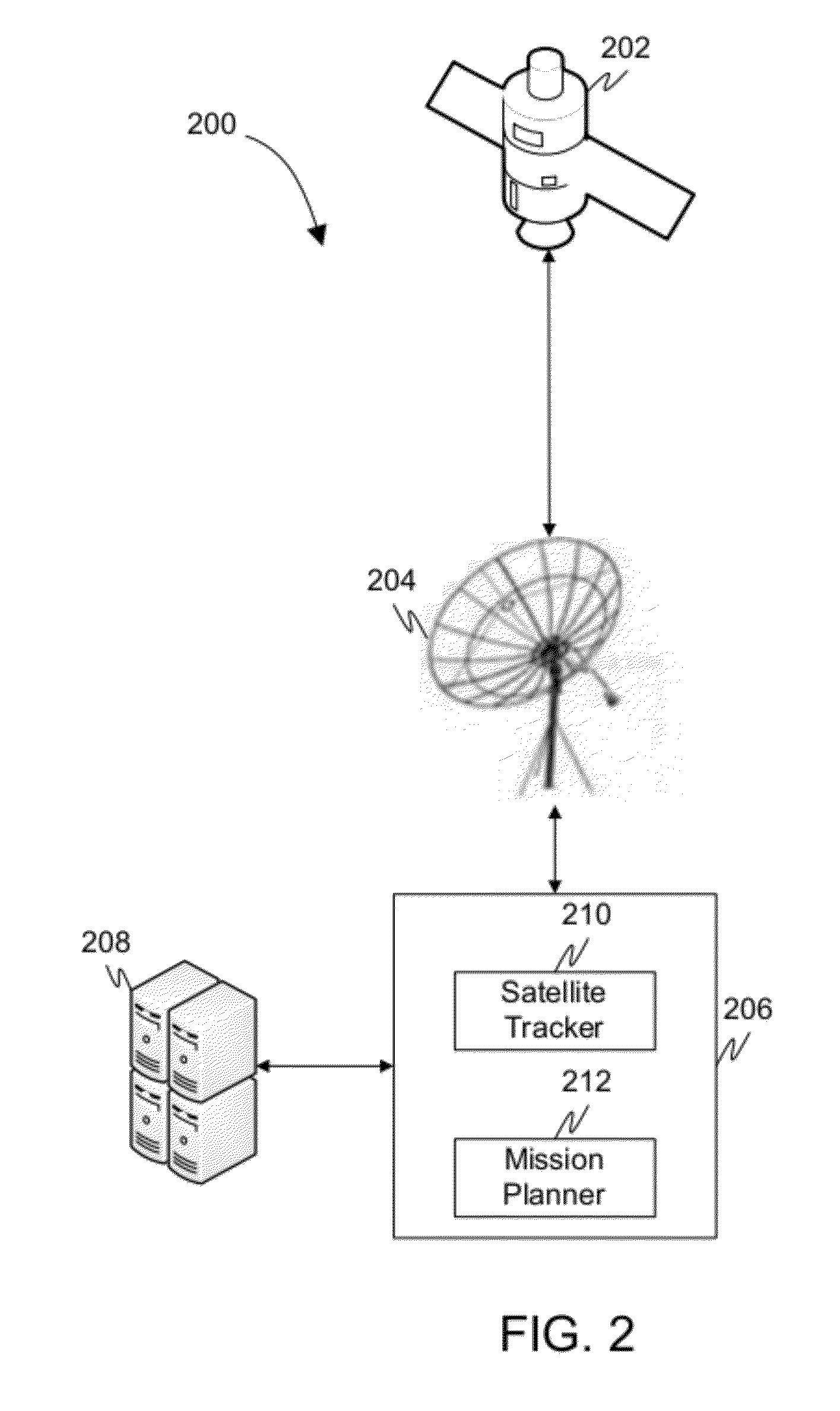
Communication and remote sensing integrated satellite system
PatentWO2023040257A1
Innovation
- An integrated remote sensing satellite system is designed. By carrying inter-satellite communication, satellite-ground communication and remote sensing application loads on the satellite platform, the attitude of the satellite platform is stable by increasing the load degree of freedom, and realizing inter-satellite communication, satellite-ground communication and remote sensing. The non-overlapping directivity of remote sensing work, the dual-degree-of-freedom remote sensing application load can be agile and maneuverable in a wide range, the satellite-to-ground communication IoT load can trigger ground sensor data in real time, and the inter-satellite communication load can ensure data transmission with neighboring satellites.


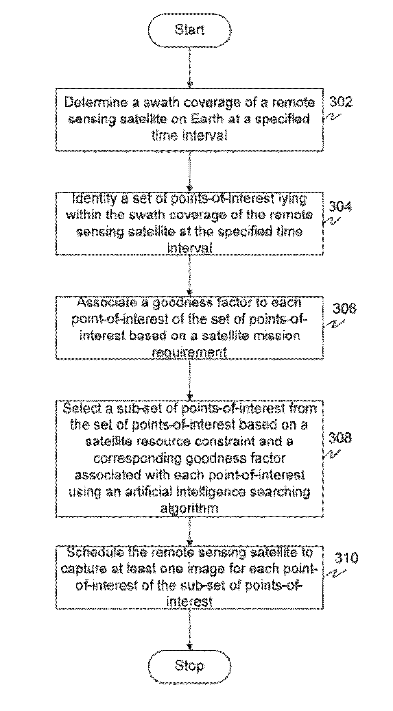
Method and system for automatically planning and scheduling a remote sensing satellite mission
PatentInactiveUS20120029812A1
Innovation
- A method and system for automatically planning and scheduling remote sensing satellite missions using a ground station, which determines swath coverage, identifies points-of-interest, associates goodness factors, and employs an artificial intelligence algorithm to select and prioritize targets based on resource constraints and mission requirements, thereby optimizing image capture.

Spectrum Allocation and Regulatory Framework
The spectrum allocation framework for Fixed Satellite Services (FSS) in advanced remote sensing applications operates within a complex regulatory environment governed by international and national authorities. The International Telecommunication Union (ITU) serves as the primary coordinating body, establishing global frequency allocations through the Radio Regulations that define specific bands for satellite services. For remote sensing applications, key frequency bands include C-band (4-8 GHz), X-band (8-12 GHz), Ku-band (12-18 GHz), and Ka-band (26.5-40 GHz), each offering distinct characteristics for data transmission and operational requirements.
National regulatory bodies, such as the Federal Communications Commission (FCC) in the United States and equivalent agencies worldwide, implement ITU guidelines while addressing domestic spectrum management needs. These agencies coordinate frequency assignments, licensing procedures, and interference mitigation strategies specific to their jurisdictions. The regulatory framework requires satellite operators to demonstrate technical compliance, orbital coordination, and interference analysis before obtaining operational licenses.
Current regulatory challenges include increasing spectrum congestion due to the proliferation of satellite constellations and growing demand for high-bandwidth remote sensing data transmission. Traditional coordination mechanisms face pressure from new entrants seeking spectrum access, particularly in commercially attractive frequency bands. Regulatory bodies are adapting through dynamic spectrum management approaches and enhanced coordination procedures.
Emerging regulatory trends focus on spectrum sharing technologies, including cognitive radio systems and real-time interference monitoring. These innovations enable more efficient spectrum utilization while maintaining service quality for critical remote sensing missions. Additionally, regulatory frameworks are evolving to accommodate new satellite architectures, including small satellite constellations and software-defined payloads that can adapt frequency usage based on operational requirements.
The regulatory landscape continues to balance competing interests between commercial satellite operators, government users, and scientific research missions, requiring ongoing coordination to ensure sustainable spectrum access for advanced remote sensing applications.
Ground Infrastructure and Data Processing Systems
Ground infrastructure and data processing systems form the backbone of fixed satellite services for advanced remote sensing projects, encompassing the terrestrial components that enable seamless satellite communication, data reception, and information processing. These systems bridge the gap between space-based sensors and end-user applications, ensuring reliable data flow and real-time processing capabilities essential for mission-critical remote sensing operations.
The ground segment architecture typically consists of multiple interconnected subsystems, including satellite tracking antennas, radio frequency equipment, baseband processing units, and high-performance computing clusters. Modern ground stations employ phased array antennas and software-defined radio technologies to maintain continuous communication links with multiple satellites simultaneously, supporting both X-band and Ka-band frequencies for high-throughput data transmission.
Data processing infrastructure has evolved significantly with the integration of cloud computing and edge processing capabilities. Contemporary systems utilize distributed computing architectures that can handle petabytes of raw satellite imagery and sensor data, implementing advanced algorithms for real-time image enhancement, atmospheric correction, and geometric rectification. Machine learning frameworks are increasingly deployed to automate feature extraction and anomaly detection processes.
Network connectivity represents a critical component, with ground stations requiring robust fiber optic connections and redundant communication pathways to ensure uninterrupted data flow to processing centers and end users. Latency optimization techniques, including edge computing nodes positioned near antenna sites, minimize processing delays for time-sensitive applications such as disaster monitoring and environmental surveillance.
Storage and archival systems employ hierarchical storage management approaches, combining high-speed solid-state drives for active processing with tape libraries for long-term data preservation. Data compression algorithms and intelligent tiering strategies optimize storage efficiency while maintaining rapid access to frequently requested datasets, supporting both operational requirements and scientific research initiatives across diverse remote sensing applications.
Unlock deeper insights with PatSnap Eureka Quick Research — get a full tech report to explore trends and direct your research. Try now!
Generate Your Research Report Instantly with AI Agent
Supercharge your innovation with PatSnap Eureka AI Agent Platform!