
Measuring method for geometrical features of tunnel appendages
A technology of geometric features and measurement methods, which is applied to measuring devices, instruments, and optical devices, can solve problems such as low efficiency, whether the state is intrusive, and high labor costs, and achieve high data collection efficiency, high resolution, and improved operation. efficiency effect
Patent Information
- Authority / Receiving Office
- CN · China
- Patent Type
- Patents(China)
- Current Assignee / Owner
- Publication Date
- 2020-09-08
Smart Images
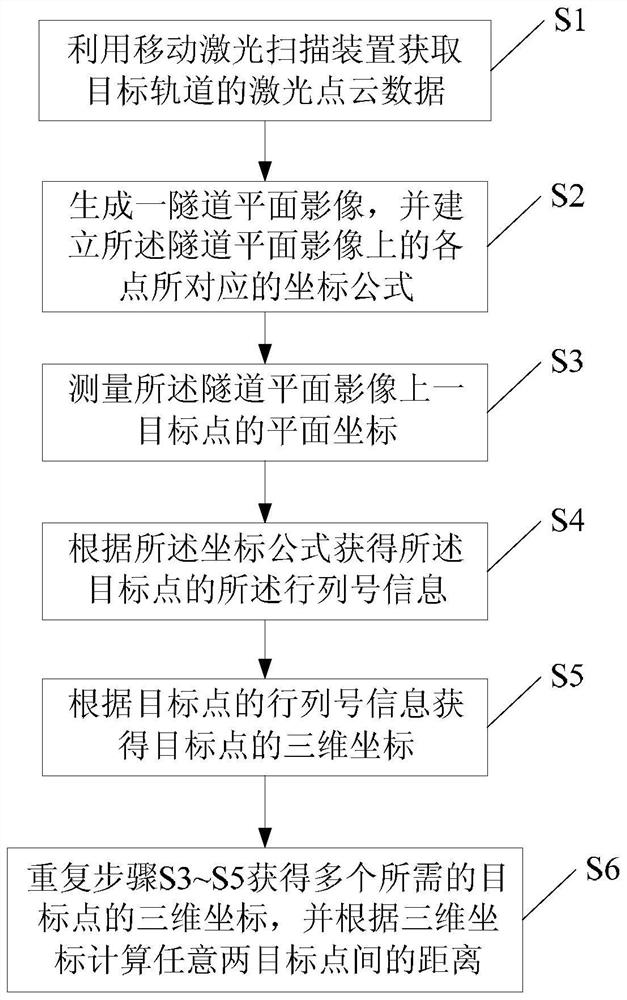
Figure 1 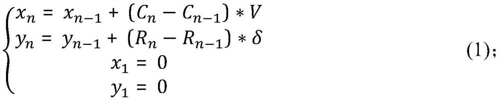
Figure 2 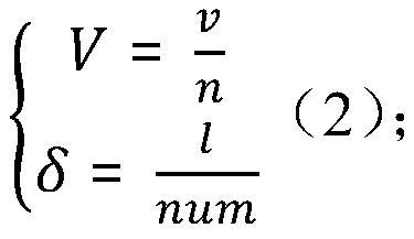
Figure 3
Abstract
Description
technical field
[0001] The invention relates to the field of tunnel measurement, in particular to a method for measuring geometric characteristics of tunnel appendages. Background technique
[0002] In order to ensure the safe operation of subway trains and monitor the safety of the tunnel, a large number of auxiliary facilities and monitoring equipment are installed inside the tunnel ring. Due to the special environment of the tunnel, while these appendages protect the safe operation of the subway, whether their own state violates the boundary is also a hidden danger. In the traditional method, it is necessary to regularly check the safety of all appendages in the tunnel through manual inspection. Or use an instrument to measure the change of its position, the efficiency is extremely low, and the labor cost is high. Contents of the invention
[0003] Aiming at the deficiencies in the above-mentioned prior art, the present invention provides a method for measuring the geo...
Examples
Embodiment Construction
[0027] According to the attached figure 1 , give a preferred embodiment of the present invention, and give a detailed description, so that the functions and characteristics of the present invention can be better understood.
[0028] see figure 1 , a method for measuring geometric characteristics of tunnel appendages according to an embodiment of the present invention, comprising the steps of:
[0029] S1: Use a mobile laser scanning device to obtain laser point cloud data of a target tunnel. The laser point cloud data includes feature data sets of multiple scanning points; feature data sets include row and column number information (C, R) corresponding to the current scanning point, Three-dimensional coordinates (X, Y, Z) and laser intensity value (I).
[0030] S2: According to the row and column number information (C n , R n ) and the laser intensity value (I) projection generate a high-resolution tunnel plane image, and establish a coordinate formula corresponding to eac...