
Method for identifying acid veins by utilizing thermal infrared hyperspectral remote sensing
A hyperspectral remote sensing and identification method technology, applied in the field of identification of acidic dikes, can solve the problems of poor extraction accuracy of acidic dikes, insufficient spectral fineness, and low spatial resolution
Patent Information
- Authority / Receiving Office
- CN · China
- Patent Type
- Applications(China)
- Current Assignee / Owner
- Publication Date
- 2020-04-21
Smart Images
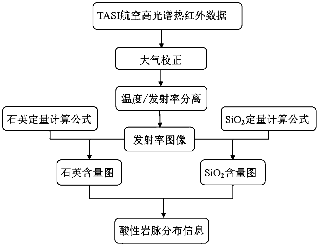
Figure 1 
Figure 2 
Figure 3
Abstract
Description
technical field
[0001] The invention belongs to the technical field of combining remote sensing information technology and structural geology, and in particular relates to a method for identifying acidic dikes by using thermal infrared hyperspectral remote sensing. Background technique
[0002] Acidic dikes are formed under the comprehensive action of geological activities such as tectonic movement and acidic magmatic activity. Therefore, accurately identifying and determining the location and distribution of acidic dykes is very important for analyzing and simulating the direction of tectonic movement, mechanical properties and magma. The nature of the activity plays a huge role.
[0003] The rapid identification and large-scale coverage of remote sensing can quickly and effectively identify acidic dikes distributed in a wide range. However, there are many kinds of remote sensing data, and thermal infrared remote sensing is the best band range for identifying acidic dikes....
Examples
Embodiment Construction
[0036] A method for identifying acidic dikes using thermal infrared hyperspectral remote sensing of the present invention will be described in detail below in conjunction with the accompanying drawings and embodiments.
[0037] A method for identifying acidic dikes using thermal infrared hyperspectral remote sensing of the present invention firstly preprocesses thermal infrared hyperspectral remote sensing data; then performs atmospheric correction and emissivity separation to obtain emissivity images; and then respectively SiO 2 Quantitative calculation of content and quartz mineral content, the SiO 2 content map and quartz mineral content map; then with high SiO 2 Bands of non-high quartz are designated as acid dikes.
[0038] Such as figure 1 As shown, a method for identifying acidic dikes using thermal infrared hyperspectral remote sensing of the present invention specifically includes the following steps:
[0039] Step 1. Thermal infrared hyperspectral remote sensing ...