
Signal processing techniques for improving the sensitivity of GPS receivers
a technology of signal processing and receiver, applied in satellite radio beaconing, measurement devices, instruments, etc., can solve the problem of minimum signal strength, achieve the effect of reducing the minimum signal strength, increasing the accuracy of carrier frequency, and facilitating rapid and reliable operation
Patent Information
- Authority / Receiving Office
- US · United States
- Patent Type
- Applications(United States)
- Current Assignee / Owner
- Publication Date
- 2011-04-07
- Estimated Expiration
- Not applicable · inactive patent
Smart Images
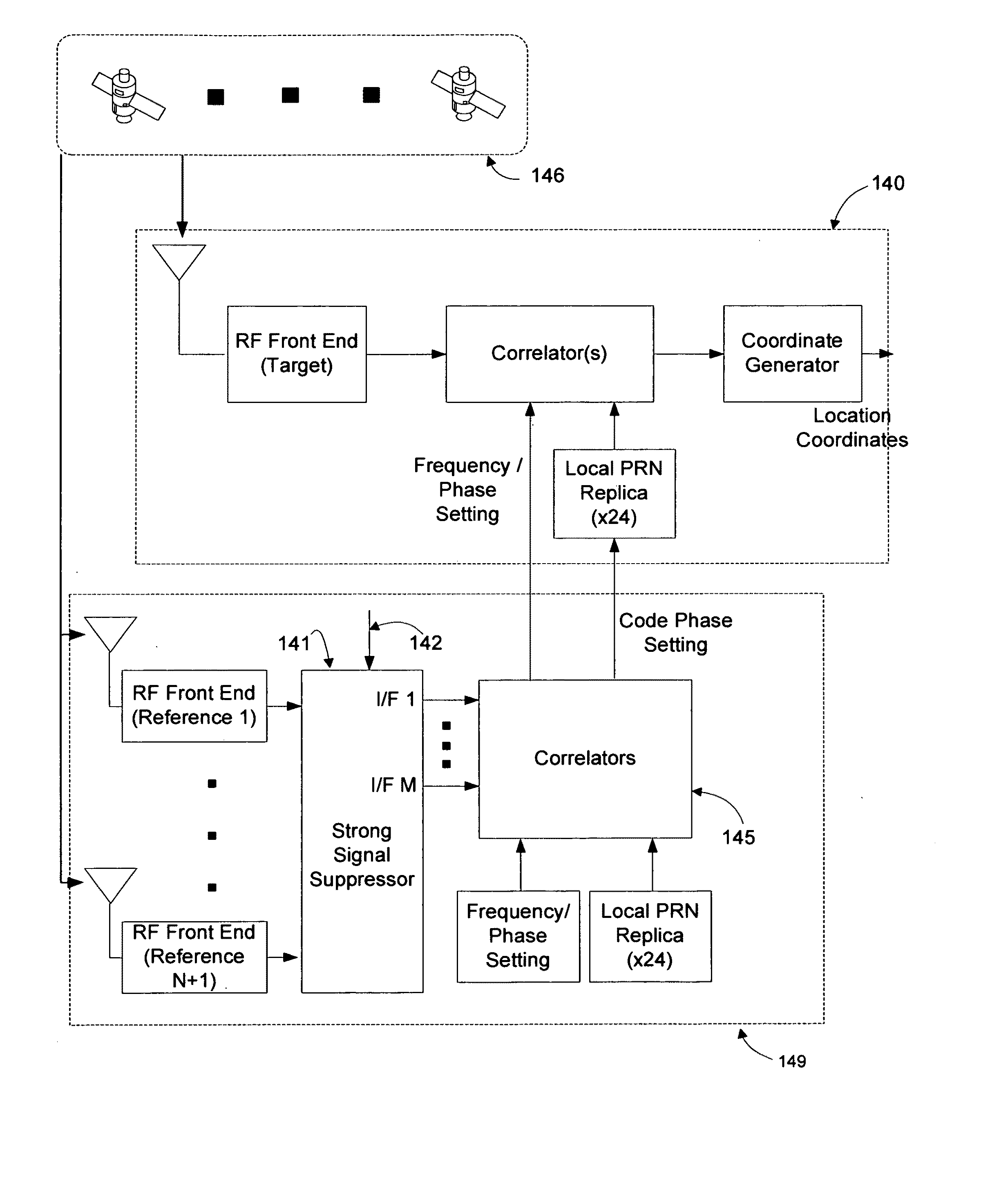
Figure 1 
Figure 2 
Figure 3
Abstract
Description
CROSS-REFERENCE TO RELATED APPLICATIONS
[0001] This application claims priority under 35 U.S.C. ξ 120 from co-pending U.S. Patent Applications entitled “Signal Processing Techniques for Improving the Receive Sensitivity of GPS Receivers”, filed contemporaneously.STATEMENT REGARDING FEDERALLY SPONSORED RESEARCH OR DEVELOPMENT
[0002] Not ApplicableBACKGROUND OF THE INVENTION
[0003] This invention relates to the determination of location coordinates of devices embodying GPS sensors.
[0004] The NAVSTAR Global Positioning System (GPS) developed by the United States Department of Defense uses a constellation of between 24 and 32 Medium Earth Orbit satellites that transmit precise microwave signals, which allows devices embodying GPS sensors to determine their current location. The initial application was predominantly for military purposes, namely weapons targeting and troop deployment. The first widespread consumer based application was navigational assistance. These early applications shared ...
Examples
Embodiment Construction
[0053]In general, the object of the present invention is to provide methods and apparatus to increase the accuracy of carrier frequency and phase as well as PRN code phase information and decoded 50 Hz data provided by GPS assistance systems to target GPS receivers to enable more rapid and reliable operation in indoor and urban canyon environments. To the extent that the satellites electronically visible to target GPS receivers inside commercial buildings are likely to be near the horizon, even as the acquisition and tracking of satellites near the horizon is peculiarly challenging for prior-art GPS assistance systems, novel techniques for reducing the minimum signal strength required by GPS assistance systems to acquire and accurately track satellites near the horizon are disclosed. The use of multiple GPS sensors provides the conceptual framework for such techniques. In this context, a GPS sensor consists of an antenna and an RF front end. To eliminate confusion, GPS sensors are c...