Analyzing Alluvial Soil Fertility with Remote Sensing Technologies
SEP 23, 20259 MIN READ
Generate Your Research Report Instantly with AI Agent
Patsnap Eureka helps you evaluate technical feasibility & market potential.
Remote Sensing for Alluvial Soil Analysis: Background and Objectives
Remote sensing technology has evolved significantly over the past decades, transforming from simple aerial photography to sophisticated multi-spectral and hyperspectral imaging systems. This technological progression has created unprecedented opportunities for soil analysis, particularly for alluvial soils which are formed by sediment deposition from flowing water. These soils, typically found in floodplains and deltas, are among the most fertile agricultural lands globally, supporting intensive crop production and food security for billions of people.
The application of remote sensing to alluvial soil fertility analysis represents a convergence of multiple scientific disciplines including soil science, spectroscopy, data analytics, and agricultural technology. Historical approaches to soil fertility assessment relied heavily on field sampling and laboratory analysis—methods that are labor-intensive, time-consuming, and provide only point-specific data. Remote sensing offers the potential to overcome these limitations by providing spatially continuous, timely, and cost-effective soil information.
Recent advancements in sensor technology have significantly improved spectral, spatial, and temporal resolution capabilities. Satellite platforms such as Landsat, Sentinel, and commercial high-resolution systems now provide regular coverage of agricultural regions worldwide. Additionally, unmanned aerial vehicles (UAVs) equipped with specialized sensors have emerged as flexible platforms for localized, high-resolution soil monitoring.
The primary objective of applying remote sensing to alluvial soil fertility analysis is to develop reliable, scalable methodologies for accurately assessing key soil properties including organic matter content, nutrient status, moisture levels, texture, and salinity. These parameters directly influence agricultural productivity and sustainability. Secondary objectives include monitoring temporal changes in soil fertility, identifying spatial patterns of soil degradation, and supporting precision agriculture practices.
Current technological trends indicate movement toward integrated sensing systems that combine multiple data sources, including optical, thermal, and radar remote sensing, alongside ground-based sensors and traditional soil testing. Machine learning and artificial intelligence algorithms are increasingly employed to extract meaningful patterns from complex, multi-dimensional remote sensing datasets.
The potential impact of advanced remote sensing for alluvial soil analysis extends beyond agricultural productivity to environmental sustainability. By enabling more precise application of fertilizers and other inputs, these technologies can help reduce nutrient runoff, minimize greenhouse gas emissions from agriculture, and promote sustainable land management practices in vulnerable alluvial ecosystems.
Looking forward, the field is progressing toward operational systems that provide actionable soil fertility information to farmers, land managers, and policymakers in near-real-time, supporting evidence-based decision making across scales from individual fields to entire watersheds and river basins.
Market Demand for Precision Agriculture Soil Monitoring
The precision agriculture market has witnessed substantial growth in recent years, with soil monitoring technologies emerging as a critical component. The global precision agriculture market was valued at $7.8 billion in 2022 and is projected to reach $15.6 billion by 2030, representing a compound annual growth rate of 9.1%. Within this broader market, soil monitoring solutions specifically focused on fertility analysis account for approximately 22% of the total market share.
Farmers and agricultural enterprises increasingly recognize the economic benefits of implementing advanced soil monitoring systems. Studies indicate that precision soil fertility management can reduce fertilizer usage by 15-30% while maintaining or improving crop yields, resulting in potential cost savings of $50-100 per hectare annually depending on crop type and region.
Alluvial soils, found in river basins and deltas worldwide, represent some of the most productive agricultural lands globally. These regions support intensive agriculture across an estimated 3.2 million square kilometers globally. The dynamic nature of alluvial soils, with their seasonal variations in nutrient content and moisture levels, creates a particularly strong demand for continuous monitoring solutions that can capture temporal changes in soil fertility parameters.
Remote sensing technologies offer significant advantages for monitoring these extensive agricultural areas compared to traditional soil sampling methods. The market for remote sensing applications in agriculture has been growing at 14.2% annually, outpacing the broader precision agriculture sector. This accelerated growth reflects the increasing recognition of remote sensing's ability to provide cost-effective, scalable solutions for large-area soil fertility assessment.
Regionally, North America currently leads the market adoption of precision soil monitoring technologies, accounting for 38% of global market share. However, the fastest growth is occurring in Asia-Pacific regions, particularly in countries with extensive alluvial farming systems such as India, Bangladesh, and China, where adoption rates have increased by over 25% annually in the past three years.
Key market drivers include increasing pressure to optimize fertilizer use amid rising input costs, growing environmental regulations regarding nutrient runoff, and the expanding availability of affordable satellite and drone-based sensing platforms. Additionally, government subsidies and incentives for sustainable farming practices in many countries are accelerating adoption rates for precision soil monitoring technologies.
Market research indicates that farmers are increasingly seeking integrated solutions that combine remote sensing data with actionable recommendations. Systems that can translate soil fertility data into specific fertilizer application maps or management zone recommendations command premium pricing, with customers willing to pay 30-40% more for solutions offering clear decision support rather than raw data alone.
Current Capabilities and Challenges in Alluvial Soil Remote Sensing
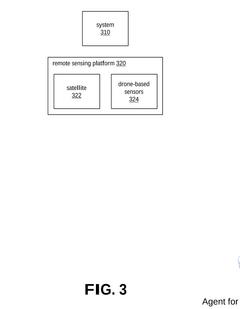
Remote sensing technologies have evolved significantly in their application to alluvial soil fertility analysis, with current capabilities spanning multiple spectral ranges and platforms. Satellite-based systems including Landsat, Sentinel, and MODIS provide regular monitoring capabilities with spatial resolutions ranging from 10 to 30 meters, enabling broad-scale assessment of alluvial plains. These platforms offer multispectral and in some cases hyperspectral imaging that can detect key soil fertility indicators such as organic matter content, moisture levels, and certain mineral compositions through spectral signatures.
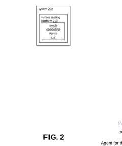
Unmanned aerial vehicles (UAVs) have emerged as complementary platforms offering higher spatial resolution (centimeter-level) and on-demand deployment capabilities. When equipped with multispectral or hyperspectral sensors, UAVs can capture detailed soil fertility variations within alluvial deposits that satellite systems might miss, particularly in smaller river valleys or delta regions.
Advanced data processing techniques including machine learning algorithms and radiative transfer models have enhanced the extraction of soil fertility parameters from remote sensing data. These computational approaches can now correlate spectral information with soil properties such as nitrogen content, phosphorus levels, and cation exchange capacity with increasing accuracy.
Despite these advancements, significant challenges persist in alluvial soil remote sensing. The heterogeneous nature of alluvial deposits creates complex spectral signatures that are difficult to interpret consistently. Spatial variability occurs at scales smaller than many satellite sensors can resolve, requiring fusion of multiple data sources for comprehensive analysis.
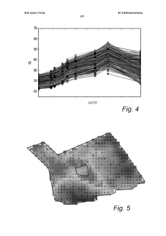
Temporal dynamics present another major challenge, as alluvial soils undergo rapid changes following flood events or seasonal variations. Current revisit frequencies of satellite platforms may be insufficient to capture these dynamic processes, particularly in regions with frequent cloud cover that limits optical sensor effectiveness.
Penetration depth limitations represent a fundamental constraint, as most remote sensing technologies can only assess surface or near-surface soil properties (typically 0-5 cm), while agriculturally relevant fertility extends deeper into the soil profile. This creates a disconnect between remotely sensed data and the complete fertility profile needed for agricultural management.
Calibration and validation challenges also persist, with ground-truth data collection in alluvial environments being labor-intensive and often limited in spatial coverage. The development of standardized protocols for relating spectral signatures to specific fertility parameters in diverse alluvial contexts remains an ongoing research need.
Unmanned aerial vehicles (UAVs) have emerged as complementary platforms offering higher spatial resolution (centimeter-level) and on-demand deployment capabilities. When equipped with multispectral or hyperspectral sensors, UAVs can capture detailed soil fertility variations within alluvial deposits that satellite systems might miss, particularly in smaller river valleys or delta regions.
Advanced data processing techniques including machine learning algorithms and radiative transfer models have enhanced the extraction of soil fertility parameters from remote sensing data. These computational approaches can now correlate spectral information with soil properties such as nitrogen content, phosphorus levels, and cation exchange capacity with increasing accuracy.
Despite these advancements, significant challenges persist in alluvial soil remote sensing. The heterogeneous nature of alluvial deposits creates complex spectral signatures that are difficult to interpret consistently. Spatial variability occurs at scales smaller than many satellite sensors can resolve, requiring fusion of multiple data sources for comprehensive analysis.
Temporal dynamics present another major challenge, as alluvial soils undergo rapid changes following flood events or seasonal variations. Current revisit frequencies of satellite platforms may be insufficient to capture these dynamic processes, particularly in regions with frequent cloud cover that limits optical sensor effectiveness.
Penetration depth limitations represent a fundamental constraint, as most remote sensing technologies can only assess surface or near-surface soil properties (typically 0-5 cm), while agriculturally relevant fertility extends deeper into the soil profile. This creates a disconnect between remotely sensed data and the complete fertility profile needed for agricultural management.
Calibration and validation challenges also persist, with ground-truth data collection in alluvial environments being labor-intensive and often limited in spatial coverage. The development of standardized protocols for relating spectral signatures to specific fertility parameters in diverse alluvial contexts remains an ongoing research need.
Current Methodologies for Remote Soil Fertility Assessment
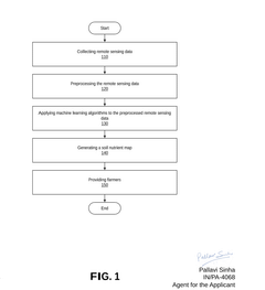
01 Satellite-based remote sensing for soil fertility assessment
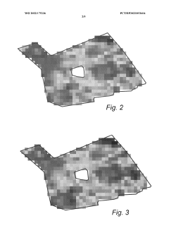
Satellite-based remote sensing technologies enable large-scale monitoring of soil fertility parameters through multispectral and hyperspectral imaging. These systems can detect variations in vegetation indices, which correlate with soil nutrient levels and overall fertility. The technology allows for non-invasive assessment of large agricultural areas, providing data on soil organic matter, moisture content, and nutrient deficiencies that affect crop growth and yield potential.- Satellite-based remote sensing for soil fertility assessment: Satellite-based remote sensing technologies enable large-scale monitoring of soil fertility parameters through multispectral and hyperspectral imaging. These systems capture data on vegetation indices, soil moisture, and mineral content, allowing farmers to assess soil fertility across vast agricultural areas without extensive ground sampling. Advanced algorithms process satellite imagery to generate soil fertility maps that highlight variations in nutrient levels and organic matter content.
- Drone-based imaging systems for precision agriculture: Unmanned aerial vehicles (UAVs) equipped with specialized sensors provide high-resolution imagery for detailed soil fertility analysis. These drone systems can capture near-infrared, thermal, and multispectral data to evaluate soil health indicators at field scale with greater precision than satellite imagery. The collected data helps in creating prescription maps for variable rate fertilizer application, optimizing nutrient management while reducing environmental impact.
- IoT sensor networks for real-time soil monitoring: Internet of Things (IoT) sensor networks deployed across agricultural fields provide continuous monitoring of soil fertility parameters. These systems incorporate in-situ sensors that measure soil moisture, temperature, pH, electrical conductivity, and nutrient levels in real-time. The collected data is transmitted wirelessly to cloud platforms where advanced analytics generate insights on soil fertility status and trends, enabling timely intervention for optimal crop production.
- Machine learning algorithms for soil fertility prediction: Advanced machine learning and artificial intelligence algorithms analyze remote sensing data to predict soil fertility parameters with high accuracy. These computational methods integrate multiple data sources including spectral imagery, topographical information, and historical crop performance to develop predictive models. The algorithms can identify patterns and correlations invisible to human analysis, enabling more precise soil fertility mapping and forecasting of nutrient requirements for different crops.
- Portable spectroscopy tools for field-level soil analysis: Handheld and portable spectroscopic devices enable rapid on-site assessment of soil fertility parameters. These tools utilize near-infrared, mid-infrared, or X-ray fluorescence spectroscopy to analyze soil samples directly in the field without chemical processing. The spectral signatures captured by these devices are processed to determine organic matter content, nutrient levels, and other fertility indicators, providing immediate results that help farmers make informed decisions about soil management practices.
02 Drone and UAV-based soil fertility mapping
Unmanned Aerial Vehicles (UAVs) equipped with specialized sensors provide high-resolution imagery for detailed soil fertility mapping. These platforms can carry multispectral cameras, thermal sensors, and other specialized equipment to collect precise data on soil conditions at various depths. The mobility and flexibility of drone technology allow for targeted assessment of specific field areas, enabling precision agriculture practices through detailed soil fertility maps that guide variable rate fertilizer application.Expand Specific Solutions03 IoT sensors and wireless networks for real-time soil monitoring
Internet of Things (IoT) sensor networks deployed across agricultural fields provide continuous, real-time monitoring of soil fertility parameters. These systems utilize in-situ sensors that measure soil moisture, temperature, pH, electrical conductivity, and nutrient levels. The data is transmitted wirelessly to central processing systems that analyze trends and alert farmers to changing soil conditions, enabling timely interventions to maintain optimal fertility levels for crop production.Expand Specific Solutions04 AI and machine learning for soil fertility prediction
Artificial intelligence and machine learning algorithms process complex remote sensing data to predict soil fertility patterns and future conditions. These systems analyze multidimensional datasets from various remote sensing sources, identifying correlations between spectral signatures and soil properties. The technology enables predictive modeling of soil nutrient dynamics, helping farmers anticipate fertility issues before they affect crop performance and allowing for proactive soil management strategies.Expand Specific Solutions05 Integrated multi-sensor systems for comprehensive soil analysis
Integrated systems combining multiple remote sensing technologies provide comprehensive soil fertility assessment by merging data from satellite imagery, ground-based sensors, and proximal soil scanning. These multi-sensor approaches overcome the limitations of individual technologies by correlating different data types to generate more accurate soil fertility maps. The integration of various sensing methods enables detailed characterization of soil physical, chemical, and biological properties that collectively determine fertility status.Expand Specific Solutions
Leading Organizations in Agricultural Remote Sensing
The remote sensing technology for alluvial soil fertility analysis is in a growth phase, with an estimated market size of $2-3 billion and expanding at 15-20% annually. The competitive landscape features academic institutions leading fundamental research (China Agricultural University, Nanjing Agricultural University, Aerospace Information Research Institute) alongside commercial players developing practical applications. Companies like Yara International, The Climate Corp, and Farmers Edge are advancing from early adoption to mainstream implementation, integrating AI and machine learning with remote sensing data. Technical maturity varies significantly across applications, with established players focusing on integration with precision agriculture systems while newer entrants like Indigo Ag and LandScan LLC are developing specialized soil-sensing technologies to enhance data resolution and accuracy.
China Agricultural University
Technical Solution: China Agricultural University has developed an integrated remote sensing approach for alluvial soil fertility assessment that combines multi-spectral satellite imagery with ground-based spectroscopy. Their system utilizes hyperspectral reflectance data to identify key soil fertility indicators including organic matter content, nitrogen, phosphorus, and potassium levels in alluvial soils. The university has pioneered the use of vegetation indices such as NDVI (Normalized Difference Vegetation Index) and EVI (Enhanced Vegetation Index) specifically calibrated for alluvial soil environments, achieving correlation coefficients of up to 0.85 between remote sensing data and actual soil fertility measurements. Their approach incorporates machine learning algorithms to process temporal satellite data, enabling the monitoring of seasonal changes in alluvial soil fertility and providing early warning systems for nutrient deficiencies.
Strengths: Highly accurate correlation between remote sensing data and ground truth measurements; comprehensive integration of multiple data sources; strong adaptation to Chinese alluvial soil conditions. Weaknesses: Requires significant ground calibration data; performance may vary in different climatic conditions; relatively high computational requirements for processing hyperspectral data.
Yara International ASA
Technical Solution: Yara International has developed the N-Sensor platform specifically adapted for alluvial soil fertility analysis. This tractor-mounted remote sensing system uses near-infrared spectroscopy to measure crop nitrogen status in real-time, allowing for variable-rate fertilizer application tailored to alluvial soil conditions. Their technology incorporates satellite imagery with proprietary algorithms to create detailed fertility maps of alluvial plains, identifying spatial variability in nutrient content. Yara's system can detect subtle differences in crop reflectance patterns that indicate varying levels of nitrogen, phosphorus, and other nutrients in alluvial soils. The company has enhanced their platform with machine learning capabilities that improve accuracy over time by correlating spectral signatures with laboratory soil analyses. Their Atfarm digital platform integrates this remote sensing data with weather information and crop models to provide farmers with actionable insights for managing alluvial soil fertility.
Strengths: Practical field-ready implementation with direct application capabilities; strong integration with fertilizer management systems; extensive validation across different alluvial soil types globally. Weaknesses: Primarily focused on nitrogen detection with less emphasis on other nutrients; requires subscription to their ecosystem; performance can be affected by atmospheric conditions.
Key Spectral Signatures and Algorithms for Alluvial Soil Characterization
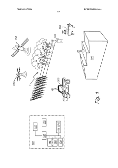
Remote soil and vegetation properties determination method and system
PatentWO2022175236A1
Innovation
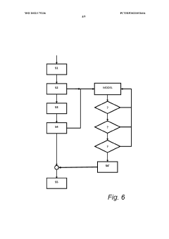
- A computer-implemented method using remote data from multiple spectral bands to generate coefficients, determine the rate of change, and calculate soil and vegetation properties, incorporating weather and field data to improve accuracy and reliability, and generate mechanistic growth models for predicting property values over time.
Remote sensing method for management of soil nutrients of cultivated land
PatentPendingIN202311019251A
Innovation
- A remote sensing method using satellite or drone-based sensors to collect data, preprocess it, apply machine learning algorithms, and generate soil nutrient maps to guide variable rate fertilization and identify remediation needs, thereby optimizing agricultural production.
Environmental Impact Assessment of Alluvial Soil Management
The management of alluvial soils carries significant environmental implications that extend beyond agricultural productivity. Remote sensing technologies provide unprecedented capabilities to monitor and assess these impacts at various spatial and temporal scales. When alluvial soil management practices are implemented, they can trigger cascading effects throughout the ecosystem, affecting water quality, biodiversity, carbon sequestration, and overall environmental health.
Water systems are particularly vulnerable to changes in alluvial soil management. Improper practices can lead to increased sedimentation in waterways, altering aquatic habitats and potentially introducing agricultural chemicals into water bodies. Remote sensing data from multispectral and hyperspectral sensors can detect changes in water turbidity and algal blooms resulting from nutrient runoff, providing early warning systems for potential environmental degradation.
Vegetation health surrounding alluvial plains serves as a critical indicator of environmental impact. Analysis of normalized difference vegetation index (NDVI) and enhanced vegetation index (EVI) derived from satellite imagery enables the assessment of riparian buffer effectiveness and natural habitat preservation. These vegetative buffers play essential roles in filtering pollutants, stabilizing banks, and maintaining biodiversity corridors.
Carbon dynamics represent another crucial environmental consideration. Alluvial soils often contain significant carbon stocks, and management decisions can either enhance carbon sequestration or trigger releases of greenhouse gases. Thermal and near-infrared remote sensing can help monitor soil organic carbon changes over time, contributing to climate change mitigation strategies and carbon accounting frameworks.
Erosion patterns and sediment transport mechanisms are fundamentally altered by human intervention in alluvial systems. Synthetic aperture radar (SAR) and LiDAR technologies offer powerful tools for quantifying topographical changes and erosion rates with centimeter-level precision. This information proves invaluable for designing sustainable management approaches that work with natural processes rather than against them.
Biodiversity impacts can be assessed through habitat fragmentation analysis using high-resolution imagery. Remote sensing allows for the identification of critical habitat patches, connectivity corridors, and areas of high conservation value within alluvial landscapes. This information supports the development of integrated management plans that balance agricultural productivity with biodiversity conservation objectives.
Climate resilience considerations must also factor into environmental impact assessments. Remote sensing time-series analysis can reveal how alluvial soil management practices affect landscape vulnerability to extreme weather events, providing insights into adaptation strategies that enhance system resilience while maintaining productive capacity.
Data Integration Frameworks for Comprehensive Soil Health Monitoring
The integration of diverse data sources is essential for developing a comprehensive soil health monitoring system, particularly for alluvial soils where fertility can vary significantly across small spatial scales. Current data integration frameworks combine satellite imagery, drone-captured data, ground-based sensors, and laboratory analyses to create multi-dimensional soil fertility models.
Leading frameworks such as the Soil Data Integration Model (SDIM) and Agricultural Remote Sensing Integration Platform (ARSIP) employ hierarchical data structures that accommodate different spatial and temporal resolutions. These systems typically utilize three-tier architectures: data acquisition, processing, and analytics layers. The acquisition layer collects raw data from various remote sensing platforms, while the processing layer handles calibration, normalization, and quality control.
Machine learning algorithms, particularly ensemble methods and deep learning networks, have proven effective in harmonizing heterogeneous data types. For example, convolutional neural networks (CNNs) can process hyperspectral imagery alongside point-based soil test results to generate continuous fertility maps with accuracy levels reaching 85-92% for key nutrients in alluvial settings.
Real-time data fusion represents a significant advancement, allowing for dynamic updating of soil fertility models as new information becomes available. Edge computing devices deployed in agricultural fields can perform preliminary data processing before transmission to central systems, reducing bandwidth requirements while maintaining analytical integrity.
Standardization remains a critical challenge, with initiatives like the Open Geospatial Consortium's SensorThings API and the INSPIRE Directive providing frameworks for interoperability. These standards enable seamless data exchange between different monitoring systems and analytical platforms, facilitating broader implementation across diverse agricultural landscapes.
Cloud-based integration platforms such as Microsoft's FarmBeats and IBM's Watson Decision Platform for Agriculture demonstrate the scalability of modern frameworks. These systems can process petabytes of soil-related data while providing accessible interfaces for stakeholders ranging from individual farmers to regional planning authorities.
The next generation of integration frameworks is moving toward "digital twin" approaches, creating virtual representations of soil systems that simulate responses to environmental changes and management practices. These models incorporate historical data alongside real-time monitoring to provide predictive capabilities for soil fertility management in alluvial contexts, enabling precision agriculture practices that optimize resource use while maintaining soil health.
Unlock deeper insights with Patsnap Eureka Quick Research — get a full tech report to explore trends and direct your research. Try now!
Generate Your Research Report Instantly with AI Agent
Supercharge your innovation with Patsnap Eureka AI Agent Platform!