

How to Mitigate Flood Risks with Robust Alluvial Soil Planning
SEP 23, 20259 MIN READ
Generate Your Research Report Instantly with AI Agent
PatSnap Eureka helps you evaluate technical feasibility & market potential.
Flood Risk Management Background and Objectives
Flood risk management has evolved significantly over the past century, transitioning from reactive approaches focused on structural defenses to more comprehensive strategies that incorporate natural processes and sustainable land use planning. Historically, flood control relied heavily on engineered solutions such as dams, levees, and channelization. However, the increasing frequency and severity of flood events globally, exacerbated by climate change, urbanization, and land use changes, have necessitated a paradigm shift in how we approach flood risk management.
Alluvial soils, formed by sediment deposition in floodplains, present unique challenges and opportunities in flood risk management. These soils are typically fertile and have historically attracted human settlement, yet their proximity to water bodies makes them inherently vulnerable to flooding. Understanding the geotechnical properties of alluvial soils, including permeability, compaction characteristics, and erosion potential, is crucial for developing effective flood mitigation strategies.
The primary objective of robust alluvial soil planning is to reduce flood-related damages while maintaining the ecological and agricultural benefits of floodplain areas. This involves developing integrated approaches that combine traditional engineering measures with nature-based solutions and land use planning. By optimizing soil management practices, communities can enhance water retention capacity, reduce runoff, and minimize erosion during flood events.
Recent technological advancements have significantly improved our ability to model and predict flood behavior in alluvial settings. Remote sensing, GIS mapping, and computational fluid dynamics now allow for more accurate assessment of flood risks and the effectiveness of various mitigation measures. These tools enable planners to develop more targeted and efficient strategies for managing alluvial soils in flood-prone areas.
The economic implications of flood events are substantial, with global annual losses estimated at over $100 billion. Effective alluvial soil planning can substantially reduce these costs while providing additional benefits such as improved water quality, enhanced biodiversity, and increased recreational opportunities. The cost-benefit ratio of preventive measures versus post-disaster recovery strongly favors investment in comprehensive flood risk management strategies.
Looking forward, the field of flood risk management through alluvial soil planning aims to develop more resilient communities that can adapt to changing climate conditions and increasing flood risks. This involves not only technical solutions but also policy frameworks that encourage sustainable land use practices and public awareness campaigns that promote community engagement in flood preparedness and response.
The ultimate goal is to transform vulnerable floodplain areas into resilient landscapes that can withstand and recover from flood events while continuing to provide valuable ecosystem services and support human activities. This requires a multidisciplinary approach that integrates engineering, ecology, hydrology, urban planning, and social sciences to address the complex challenges of living with floods.
Market Analysis for Flood Mitigation Solutions
The global market for flood mitigation solutions has experienced significant growth in recent years, driven by increasing frequency and severity of flood events worldwide. Current market valuation stands at approximately $7 billion, with projections indicating growth to reach $10 billion by 2027, representing a compound annual growth rate of 6.2%. This expansion is particularly evident in regions with extensive alluvial soil deposits, which present unique challenges for flood management.
Demand for alluvial soil-specific flood mitigation technologies has seen a marked increase in densely populated river deltas across Asia, particularly in countries like Bangladesh, India, and China. These regions combine high population density with extensive agricultural activities on alluvial plains, creating substantial market opportunities. The North American market shows strong demand for advanced technological solutions, while European markets emphasize integrated approaches that combine traditional engineering with nature-based solutions.
Market segmentation reveals distinct categories within flood mitigation solutions for alluvial soils. Structural measures, including specialized foundations, soil stabilization systems, and permeable surfaces, constitute approximately 45% of the market. Non-structural approaches, such as early warning systems, land-use planning tools, and insurance products, represent 30%. The remaining 25% encompasses hybrid solutions that integrate both approaches, showing the fastest growth rate at 8.7% annually.
Customer analysis indicates three primary market segments: government agencies (55% of procurement), private developers (25%), and agricultural enterprises (20%). Government spending on flood resilience infrastructure has increased by 15% over the past five years, reflecting growing recognition of climate change impacts on flood frequency and intensity.
Regional market analysis shows Asia-Pacific leading with 38% market share, followed by North America (27%), Europe (22%), and rest of world (13%). Notably, emerging economies are adopting flood mitigation technologies at an accelerated pace, with annual growth rates exceeding 10% in Southeast Asia and parts of Latin America.
Key market drivers include increasing urbanization in flood-prone areas, rising property values in coastal and riverine zones, growing insurance costs associated with flood damage, and strengthening regulatory frameworks requiring flood risk assessment and mitigation. The COVID-19 pandemic temporarily slowed market growth in 2020-2021, but recovery has been robust, with increased emphasis on infrastructure resilience and disaster preparedness.
Market barriers include high implementation costs, fragmented regulatory environments across jurisdictions, limited public awareness of alluvial soil-specific risks, and technical challenges in adapting solutions to diverse geological conditions. Despite these challenges, the market outlook remains positive, supported by increasing climate adaptation funding and technological innovations in soil engineering and hydrological modeling.
Current Challenges in Alluvial Soil Engineering
Alluvial soils, formed by sediment deposition from rivers and streams, present unique engineering challenges in flood-prone regions. These soils exhibit variable composition, ranging from fine silts and clays to coarse sands and gravels, resulting in heterogeneous geotechnical properties that complicate construction and flood mitigation efforts.
One of the primary challenges is the inherent instability of alluvial deposits. These soils often display poor consolidation characteristics, high compressibility, and susceptibility to liquefaction during seismic events or prolonged flooding. This instability can lead to foundation failures, structural damage, and increased vulnerability during flood events, particularly in densely populated floodplains.
Hydrological complexity represents another significant obstacle. Alluvial soils typically feature complex groundwater dynamics with high water tables and variable permeability. These characteristics create difficulties in predicting subsurface water movement, designing effective drainage systems, and implementing flood control measures. Engineers must account for both surface runoff and groundwater infiltration patterns that can change dramatically during flood events.
Erosion susceptibility poses a persistent threat to infrastructure built on alluvial soils. During flood events, the erosive force of flowing water can rapidly undermine foundations, scour bridge supports, and compromise flood defense structures. This erosion potential is often exacerbated by the loose, unconsolidated nature of recently deposited alluvial materials, particularly along riverbanks and coastal areas.
Climate change has intensified these challenges by altering precipitation patterns and increasing the frequency and severity of extreme weather events. Rising sea levels and more intense rainfall events are placing unprecedented stress on existing flood protection systems designed under historical climate assumptions. This new reality demands innovative approaches to alluvial soil engineering that can accommodate greater uncertainty and resilience requirements.
Regulatory frameworks and land-use policies often fail to adequately address the specific challenges of alluvial soil engineering. Many building codes and infrastructure standards were developed for more stable soil conditions and may not provide sufficient guidance for construction in dynamic alluvial environments. This regulatory gap can lead to inappropriate development in high-risk areas and inadequate engineering solutions.
Technical limitations in soil improvement methods represent another obstacle. While various ground improvement techniques exist, their application in extensive alluvial deposits can be prohibitively expensive or logistically challenging. Engineers must balance cost considerations with performance requirements when designing foundations and flood protection systems in these environments.
Existing Alluvial Soil Stabilization Methods
01 Flood risk assessment and prediction systems
Advanced systems for assessing and predicting flood risks in alluvial soil areas, incorporating data analytics, machine learning, and real-time monitoring. These systems analyze historical flood data, soil characteristics, and environmental factors to generate accurate flood risk maps and early warning systems, enabling better preparation and response to potential flooding events.- Flood risk assessment and prediction systems: Advanced systems for assessing and predicting flood risks in alluvial soil areas, utilizing data analytics, machine learning, and hydrological modeling. These systems analyze historical flood data, soil characteristics, topography, and weather patterns to generate accurate flood risk maps and early warning systems, enabling better preparation and response to potential flooding events.
- Land use planning and zoning for flood-prone alluvial areas: Methodologies for optimal land use planning and zoning in flood-prone alluvial soil regions. These approaches incorporate flood risk data into urban and rural development plans, establishing appropriate zoning regulations, building codes, and land use restrictions. The goal is to minimize development in high-risk areas while promoting sustainable land use practices that accommodate the natural flooding cycles of alluvial plains.
- Engineered soil management and stabilization techniques: Innovative techniques for managing and stabilizing alluvial soils to reduce flood risks. These include soil reinforcement methods, erosion control systems, and soil composition modifications that enhance drainage capabilities while maintaining structural integrity. Such techniques help prevent soil erosion during flooding events and improve the overall resilience of alluvial landscapes against water-related damages.
- Integrated water management and drainage systems: Comprehensive water management and drainage solutions specifically designed for alluvial soil environments. These systems incorporate sustainable drainage infrastructure, water retention facilities, and controlled water flow mechanisms to manage excess water during flood events. The integration of natural and engineered drainage solutions helps to reduce flood impacts while preserving the beneficial properties of alluvial soils.
- Insurance and financial risk management for flood-prone areas: Financial and insurance frameworks developed specifically for properties and infrastructure in flood-prone alluvial soil regions. These solutions include specialized risk assessment methodologies, insurance products, and financial planning tools that account for the unique characteristics of alluvial soil flood risks. Such approaches help distribute financial burden and incentivize appropriate land use and building practices in vulnerable areas.
02 Land use planning and zoning for flood-prone alluvial areas
Methodologies for optimal land use planning and zoning in flood-prone alluvial soil regions. These approaches incorporate soil analysis, topographical mapping, and hydrological modeling to determine suitable development zones, buffer areas, and restricted zones. By integrating flood risk data into urban and rural planning processes, communities can develop more resilient infrastructure and reduce potential flood damage.Expand Specific Solutions03 Engineered drainage and water management solutions
Innovative drainage and water management systems specifically designed for alluvial soil environments. These solutions include permeable surfaces, bioswales, retention ponds, and engineered channels that work with the natural properties of alluvial soil to manage excess water during flood events. The systems help to redirect, store, and gradually release floodwater, reducing the impact on surrounding areas.Expand Specific Solutions04 Insurance and financial risk management for flood-prone areas
Financial and insurance frameworks designed to address the economic risks associated with developing on alluvial soils in flood-prone regions. These approaches include specialized insurance products, risk-based pricing models, and financial incentives for implementing flood mitigation measures. By quantifying and distributing flood risks, these systems help make development in alluvial soil areas more economically sustainable.Expand Specific Solutions05 Soil stabilization and reinforcement techniques
Methods for stabilizing and reinforcing alluvial soils to increase their resistance to erosion and structural failure during flood events. These techniques include the use of geotextiles, soil amendments, vegetation management, and specialized construction methods that account for the unique properties of alluvial deposits. By enhancing soil stability, these approaches reduce the likelihood of landslides, erosion, and structural damage during flooding.Expand Specific Solutions
Key Organizations in Flood Risk Management
The flood risk mitigation landscape is currently in a growth phase, with increasing market demand driven by climate change impacts. The global market for flood management solutions is expanding rapidly, estimated to reach several billion dollars annually. Technologically, the field shows varying maturity levels across different approaches. Leading organizations like Nanjing Hydraulic Research Institute and China Institute of Water Resources & Hydropower Research have developed advanced structural solutions, while IBM is pioneering AI-based predictive systems. Companies such as Geopier Foundation and Arx Pax Labs are innovating with novel soil stabilization technologies. Academic institutions including Tsinghua University and Southeast University contribute significant research advancements, creating a competitive ecosystem where traditional engineering approaches increasingly integrate with digital technologies for comprehensive flood resilience solutions.
Nanjing Hydraulic Research Institute
Technical Solution: Nanjing Hydraulic Research Institute (NHRI) has developed comprehensive alluvial soil management systems for flood control that integrate geotechnical engineering with hydrological modeling. Their approach includes multi-layered soil stabilization techniques that enhance the load-bearing capacity of alluvial soils while maintaining natural drainage patterns. NHRI's technology incorporates real-time monitoring systems that track soil moisture content, pore water pressure, and soil deformation to predict potential failure points during flood events. They have pioneered the use of permeable reactive barriers in alluvial plains that allow controlled water flow while filtering contaminants. Their flood risk mitigation strategy also includes engineered vegetation systems that utilize deep-rooting plants to increase soil cohesion and reduce erosion in flood-prone alluvial areas.
Strengths: Extensive experience with China's diverse river systems provides practical implementation knowledge; strong integration of monitoring technology with physical interventions. Weaknesses: Solutions may be optimized for specific regional conditions in China and require adaptation for different geological contexts; high implementation costs for comprehensive monitoring systems.
Institute of Mountain Hazards & Environment IMHE of CAS
Technical Solution: The Institute of Mountain Hazards & Environment has developed specialized techniques for managing alluvial soil in mountainous regions where flash flooding presents unique challenges. Their approach combines terrain analysis with soil reinforcement strategies specifically designed for steep gradients. IMHE's technology includes engineered terracing systems that incorporate geotextile reinforcement layers to stabilize alluvial deposits on slopes. They have pioneered debris flow interception structures that protect downstream alluvial plains by controlling sediment transport during extreme precipitation events. Their research has led to the development of composite soil amendments that enhance cohesion in loose alluvial deposits while maintaining permeability. IMHE also employs advanced remote sensing and GIS modeling to identify high-risk alluvial zones and optimize intervention placement.
Strengths: Specialized expertise in complex mountain terrain environments where traditional flood control measures often fail; integration of ecological principles with engineering solutions. Weaknesses: Solutions primarily focused on mountainous regions may have limited applicability in flat alluvial plains; implementation can be logistically challenging in remote areas.
Critical Geotechnical Innovations for Flood Zones
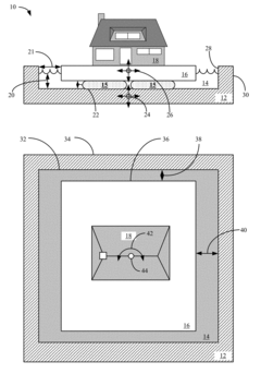
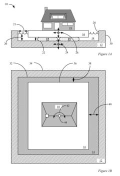
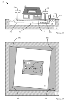
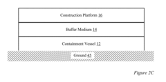
Methods and apparatus of building construction resisting earthquake and flood damage
PatentActiveUS20170321444A1
Innovation
- A three-part foundation system comprising a containment vessel, a buffer medium, and a construction platform, where the platform floats on the buffer medium, minimizing seismic forces during earthquakes and allowing buildings to rise with floodwaters, thereby reducing damage from both seismic and flood events.
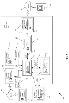
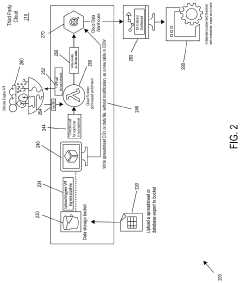
Systems and methods for generating visual representations of climate hazard risks
PatentPendingUS20230143540A1
Innovation
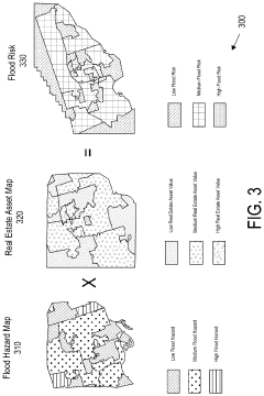
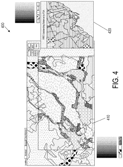
- A system and method utilizing geolocation data to generate visual representations of climate hazard risks through a global climate platform, combining a climate hazard dashboard, cloud data warehouse, and business intelligence analytics to create maps that overlay flood hazard data with real estate asset data, enabling users to understand risk scenarios and probabilities.
Climate Change Impacts on Flood Risk Planning
Climate change is fundamentally altering the frequency, intensity, and predictability of flood events worldwide, creating unprecedented challenges for flood risk planning in alluvial soil regions. Global temperature increases have accelerated the hydrological cycle, resulting in more extreme precipitation events that overwhelm traditional flood defense systems. Research indicates that for each degree Celsius of warming, the atmosphere can hold approximately 7% more moisture, directly translating to heavier rainfall during storm events.
In alluvial soil contexts, these climate-driven changes manifest through multiple pathways. Rising sea levels—projected to increase by 0.3-1.2 meters by 2100—are pushing saltwater further inland, compromising soil stability in coastal alluvial plains and exacerbating flood impacts. Simultaneously, changing precipitation patterns are altering river discharge rates, with many regions experiencing longer dry periods punctuated by intense rainfall events that generate flash floods with minimal warning time.
The destabilization of seasonal weather patterns further complicates flood risk planning. Historical flood data, once the foundation of risk assessment and infrastructure design, has become increasingly unreliable as climate change creates non-stationary conditions. This "climate stationarity" problem undermines traditional probability-based approaches to flood management in alluvial environments, necessitating more dynamic and adaptive planning methodologies.
Watershed-level impacts present additional challenges, as changes in upstream precipitation and land use interact with climate factors to modify sediment transport dynamics in alluvial systems. Higher intensity rainfall events increase erosion rates, potentially altering river channel morphology and floodplain characteristics over relatively short timeframes. These geomorphological changes can render existing flood protection infrastructure inadequate or even counterproductive.
Climate models project that these trends will accelerate through mid-century, with particular vulnerability in tropical and subtropical regions where many major alluvial plains support dense human populations. The IPCC's Sixth Assessment Report highlights that even under moderate emission scenarios, many regions will experience 1-in-100-year flood events at 5-10 times their historical frequency by 2050.
Economic analyses suggest that without significant adaptation measures specifically addressing climate change impacts on alluvial soil management, annual flood damages could increase by 160-240% globally by mid-century. This underscores the urgent need for flood risk planning approaches that explicitly incorporate climate projections rather than relying solely on historical data, particularly in regions dominated by alluvial soils where flood dynamics are especially sensitive to changing hydrological conditions.
Cost-Benefit Analysis of Preventive Measures
The implementation of flood risk mitigation strategies through alluvial soil planning requires significant investment, making cost-benefit analysis essential for decision-makers. This analysis evaluates the economic efficiency of preventive measures by comparing implementation costs against potential damage reduction benefits over time.
Initial capital expenditures for structural measures such as levees, flood walls, and soil stabilization systems typically range from $1,000 to $5,000 per linear meter, depending on design specifications and local conditions. Non-structural approaches like land-use zoning and early warning systems generally require lower upfront investments but may involve substantial administrative costs and potential economic opportunity losses.
When analyzing benefits, direct damage prevention constitutes the primary quantifiable advantage. Historical flood data indicates that well-planned alluvial soil management can reduce property damage by 40-70% in high-risk zones. For example, the Netherlands' comprehensive flood management system demonstrates a benefit-cost ratio of approximately 7:1 over its lifetime, with initial investments recouped within 12-15 years through avoided damages.
Indirect benefits, though more challenging to quantify, include reduced business interruption losses, decreased emergency response costs, and lower insurance premiums. Studies suggest these secondary benefits may add 30-50% to the direct damage prevention value, significantly enhancing overall economic returns.
Long-term maintenance costs must be factored into comprehensive analyses. Annual maintenance typically requires 2-5% of initial capital costs, with major refurbishments necessary every 15-20 years. Failure to account for these ongoing expenses can undermine the sustainability of preventive measures.
Risk-adjusted calculations incorporating climate change projections reveal that preventive measures become increasingly cost-effective as flood frequency and severity intensify. Under moderate climate change scenarios, benefit-cost ratios for comprehensive alluvial soil management systems are projected to increase by 15-25% by 2050.
Sensitivity analysis demonstrates that the economic viability of preventive measures remains robust across various discount rates (3-7%) and implementation timelines. However, effectiveness diminishes significantly when implementation is delayed beyond critical thresholds or when maintenance is inadequate, potentially reducing benefit-cost ratios by up to 40%.
The distribution of costs and benefits among stakeholders presents additional considerations. While initial investments often fall to public entities, benefits accrue to diverse stakeholders including property owners, businesses, and insurance companies, necessitating innovative financing mechanisms to align incentives appropriately.
Unlock deeper insights with PatSnap Eureka Quick Research — get a full tech report to explore trends and direct your research. Try now!
Generate Your Research Report Instantly with AI Agent
Supercharge your innovation with PatSnap Eureka AI Agent Platform!