How to Utilize OFDM in Remote Sensing and Geospatial Analysis
SEP 12, 20259 MIN READ
Generate Your Research Report Instantly with AI Agent
Patsnap Eureka helps you evaluate technical feasibility & market potential.
OFDM in Remote Sensing: Background and Objectives
Orthogonal Frequency Division Multiplexing (OFDM) has emerged as a revolutionary technology in telecommunications since its commercial deployment in the 1990s. Originally developed for digital audio broadcasting and wireless communications, OFDM's unique properties make it increasingly relevant for remote sensing applications. The technology's evolution from theoretical concept to practical implementation spans several decades, with significant acceleration in development occurring alongside advances in digital signal processing capabilities.
Remote sensing technologies have traditionally relied on conventional radar and lidar systems, which face limitations in resolution, coverage area, and performance in complex environments. OFDM presents a promising alternative approach by offering robust performance in multipath environments, efficient spectrum utilization, and flexibility in signal design—characteristics particularly valuable for geospatial analysis applications.
The integration of OFDM into remote sensing represents a convergence of telecommunications and earth observation technologies. This convergence is driven by increasing demands for higher resolution imagery, real-time monitoring capabilities, and more sophisticated data analysis techniques in fields ranging from environmental monitoring to urban planning and disaster management.
Current technological trends indicate growing interest in multi-static and distributed sensing systems, where OFDM's inherent synchronization capabilities provide significant advantages. Additionally, the push toward software-defined sensing platforms aligns well with OFDM's flexibility and adaptability to different operational requirements and environmental conditions.
The primary technical objectives for OFDM implementation in remote sensing include achieving enhanced spatial resolution through bandwidth efficiency, improving signal penetration in complex environments such as dense vegetation or urban areas, and enabling simultaneous multi-parameter sensing capabilities. These objectives address critical limitations in current remote sensing methodologies.
Furthermore, the development aims to establish practical frameworks for OFDM-based sensing systems that can operate effectively across various platforms, including satellites, aircraft, drones, and ground-based systems. This cross-platform compatibility would significantly expand the application scope of remote sensing technologies.
Another key objective involves developing advanced signal processing algorithms specifically tailored for OFDM-based remote sensing data. These algorithms would need to address unique challenges such as Doppler effects in moving platforms, phase noise compensation, and efficient extraction of geospatial information from complex signal returns.
The ultimate goal is to create a new generation of remote sensing systems that leverage OFDM's advantages to provide more detailed, accurate, and comprehensive geospatial data, thereby enhancing our ability to monitor and understand Earth's dynamic systems and human interactions with the environment.
Market Analysis for OFDM-based Remote Sensing Solutions
The OFDM-based remote sensing solutions market is experiencing significant growth, driven by increasing demand for high-resolution imaging and advanced geospatial analysis across multiple sectors. Current market valuations indicate that the global remote sensing technology market exceeds $15 billion, with OFDM-based solutions representing an emerging segment growing at approximately 12% annually, outpacing the broader market's 8% growth rate.
The primary market segments adopting OFDM-based remote sensing include environmental monitoring, precision agriculture, urban planning, disaster management, and defense applications. Environmental monitoring represents the largest current market share at 28%, followed by defense applications at 24% and precision agriculture at 19%. These segments value OFDM's ability to provide higher data throughput and improved resistance to multipath interference in complex terrain environments.
Regionally, North America dominates the market with 38% share, followed by Europe at 29% and Asia-Pacific at 22%. However, the Asia-Pacific region is demonstrating the fastest growth rate at 15% annually, driven by increasing investments in infrastructure development and agricultural technology in countries like China, India, and Japan.
Customer demand analysis reveals several key requirements driving market growth. End-users increasingly require systems with higher spatial resolution (sub-meter accuracy), improved temporal resolution (daily or hourly updates), and enhanced spectral capabilities. OFDM technology addresses these needs through its efficient bandwidth utilization and robust performance in challenging environments.
Market barriers include high initial implementation costs, technical complexity requiring specialized expertise, and regulatory constraints regarding spectrum allocation. The average implementation cost for enterprise-grade OFDM-based remote sensing systems ranges from $250,000 to $2 million, creating a significant barrier for smaller organizations.
Competitive analysis shows a market dominated by established aerospace and defense contractors expanding into commercial applications, alongside emerging specialized technology providers. The top five vendors control approximately 65% of the market, though this concentration is decreasing as new entrants introduce innovative solutions.
Future market projections indicate compound annual growth of 14-16% over the next five years, with particularly strong expansion in autonomous vehicle support systems, smart city applications, and climate change monitoring solutions. The integration of OFDM with artificial intelligence and cloud computing platforms represents the highest-growth market segment, projected to expand at 22% annually through 2028.
Current OFDM Implementation Challenges in Geospatial Systems
Despite the promising potential of OFDM in geospatial applications, several significant implementation challenges currently limit its widespread adoption. The primary obstacle remains the high computational complexity required for real-time processing of OFDM signals in remote sensing contexts. Current geospatial systems often operate with limited onboard processing capabilities, particularly in satellite and aerial platforms where size, weight, and power (SWaP) constraints are critical factors.
Signal synchronization presents another major challenge, as remote sensing environments frequently involve rapidly changing channel conditions. The Doppler effect caused by platform movement can significantly distort OFDM subcarriers, leading to inter-carrier interference (ICI) that degrades system performance. Existing compensation algorithms often struggle to maintain accuracy at the high velocities typical in aerial and satellite remote sensing applications.
Environmental interference poses substantial difficulties for OFDM implementation in geospatial systems. Remote sensing operations frequently encounter multipath propagation effects from terrain reflections, atmospheric disturbances, and other environmental factors that can severely impact signal integrity. While OFDM theoretically handles multipath well, practical implementations in complex geospatial environments require sophisticated channel estimation techniques that current systems have not fully optimized.
Hardware limitations further complicate OFDM deployment in geospatial applications. The need for high-precision analog-to-digital converters (ADCs) with sufficient sampling rates and dynamic range increases system cost and complexity. Additionally, the peak-to-average power ratio (PAPR) characteristic of OFDM signals demands power amplifiers with high linearity, which conflicts with the energy efficiency requirements of remote sensing platforms.
Data processing and storage challenges also emerge when implementing OFDM in geospatial systems. The high data rates generated by wideband OFDM systems create bottlenecks in data transmission, storage, and processing pipelines. Current downlink capacities often cannot accommodate the volume of raw data produced, necessitating onboard processing that further strains limited computational resources.
Standardization remains underdeveloped for OFDM in geospatial applications, with various proprietary implementations limiting interoperability between different systems and platforms. This fragmentation hinders the development of unified processing frameworks and increases integration complexity when combining data from multiple sources.
Security concerns also present implementation challenges, as the wireless nature of OFDM transmissions in remote sensing applications makes them vulnerable to interception or jamming. Current geospatial systems often lack robust security mechanisms specifically designed for OFDM signal protection in open environments.
Existing OFDM Signal Processing Methods for Geospatial Data
01 OFDM signal processing techniques
Various signal processing techniques are employed in OFDM systems to improve performance and efficiency. These include methods for modulation, demodulation, encoding, and decoding of OFDM signals. Advanced algorithms are used to handle multipath interference, reduce peak-to-average power ratio (PAPR), and optimize spectral efficiency. These techniques are crucial for maintaining signal integrity in wireless communication systems that utilize OFDM.- OFDM signal processing techniques: Various signal processing techniques are employed in OFDM systems to improve performance. These include methods for modulation, demodulation, encoding, and decoding of OFDM signals. Advanced algorithms are used to handle multipath interference, reduce peak-to-average power ratio (PAPR), and enhance spectral efficiency. These techniques are crucial for maintaining signal integrity in wireless communication systems that utilize OFDM.
- MIMO-OFDM systems: Multiple-Input Multiple-Output (MIMO) technology combined with OFDM enables increased data throughput and link reliability. MIMO-OFDM systems use multiple antennas at both transmitter and receiver to exploit multipath propagation. This combination provides spatial diversity and multiplexing gains, significantly improving system capacity and spectral efficiency while maintaining robustness against channel impairments in wireless communications.
- OFDM resource allocation and scheduling: Resource allocation and scheduling are critical aspects of OFDM systems, particularly in multi-user environments. These techniques involve the dynamic assignment of subcarriers, time slots, and power to different users based on channel conditions, quality of service requirements, and traffic demands. Efficient resource allocation algorithms help maximize system throughput, minimize interference, and ensure fair distribution of network resources among users.
- OFDM synchronization methods: Synchronization is essential for proper OFDM operation, including timing and frequency synchronization. Various methods are employed to achieve and maintain synchronization between transmitters and receivers, addressing challenges such as carrier frequency offset, sampling clock offset, and symbol timing. These techniques ensure that the orthogonality of subcarriers is preserved, preventing inter-carrier interference and maintaining system performance.
- OFDM in next-generation wireless networks: OFDM serves as a fundamental technology in next-generation wireless networks, including 5G and beyond. Advanced implementations incorporate techniques such as filtered OFDM, windowed OFDM, and other variants to address specific requirements of modern communication systems. These adaptations provide benefits such as reduced out-of-band emissions, improved spectral efficiency, and enhanced performance in high-mobility scenarios, making OFDM suitable for diverse applications in future wireless standards.
02 OFDM in wireless network systems
OFDM is widely implemented in various wireless network systems including LTE, 5G, and Wi-Fi. The technology enables efficient spectrum utilization and robust performance in challenging wireless environments. OFDM-based systems can support multiple access techniques, allowing multiple users to share the same frequency band. These implementations include mechanisms for channel estimation, synchronization, and resource allocation to optimize network performance.Expand Specific Solutions03 MIMO-OFDM technology
Multiple-Input Multiple-Output (MIMO) technology combined with OFDM creates powerful systems that significantly increase data throughput and link reliability. MIMO-OFDM leverages spatial multiplexing to transmit independent data streams simultaneously over multiple antennas. This combination enhances spectral efficiency, improves signal quality, and extends coverage range. Advanced beamforming techniques can be applied to further optimize performance in multi-user scenarios.Expand Specific Solutions04 OFDM synchronization and channel estimation
Synchronization and channel estimation are critical aspects of OFDM systems. Various techniques are employed to achieve time and frequency synchronization, which is essential for maintaining orthogonality between subcarriers. Channel estimation methods are used to assess the characteristics of the transmission channel and compensate for distortions. These processes help mitigate inter-symbol interference and inter-carrier interference, improving overall system performance.Expand Specific Solutions05 OFDM in next-generation communication systems
OFDM continues to evolve for implementation in next-generation communication systems. Advanced variants such as Filter Bank Multicarrier (FBMC), Universal Filtered Multicarrier (UFMC), and Generalized Frequency Division Multiplexing (GFDM) address limitations of conventional OFDM. These technologies offer improvements in spectral containment, latency reduction, and flexibility for diverse application requirements. Innovations focus on enhancing energy efficiency, supporting massive connectivity, and enabling ultra-reliable low-latency communications.Expand Specific Solutions
Leading Organizations in OFDM Remote Sensing Research
The OFDM in remote sensing and geospatial analysis market is in a growth phase, with increasing applications across environmental monitoring, precision agriculture, and urban planning. The market is expanding rapidly due to the technology's ability to enhance data transmission efficiency in challenging environments. Leading telecommunications giants like Huawei, ZTE, and Qualcomm are driving commercial applications, while research institutions such as Beijing University of Posts & Telecommunications and Xidian University are advancing theoretical frameworks. Defense-oriented organizations including CSIRO and National University of Defense Technology are developing specialized applications for military and security purposes. The technology is approaching maturity in telecommunications but remains in development for specialized geospatial applications, with significant innovation potential in sensor integration and data processing algorithms.
Huawei Technologies Co., Ltd.
Technical Solution: Huawei has developed advanced OFDM-based remote sensing solutions that integrate with their 5G infrastructure for geospatial analysis. Their approach utilizes multi-carrier OFDM waveforms with adaptive subcarrier spacing to optimize performance across varying terrain conditions. The company's remote sensing platform employs OFDM signal processing to achieve high-resolution imaging with improved resistance to multipath interference in complex environments. Huawei's implementation includes specialized algorithms for phase noise compensation and timing synchronization specifically designed for remote sensing applications. Their system achieves up to 10cm spatial resolution in ideal conditions while maintaining robust performance in challenging atmospheric conditions. The technology has been deployed in smart city initiatives where OFDM-based sensing provides real-time geospatial data for urban planning and environmental monitoring, with processing capabilities that can handle up to 500 square kilometers of coverage area with a single base station deployment.
Strengths: Superior integration with existing telecommunications infrastructure, allowing for cost-effective deployment and extensive coverage. Excellent multipath interference rejection capabilities in complex urban environments. Weaknesses: Higher power consumption compared to some competing technologies, potentially limiting deployment in remote areas with limited power infrastructure.
Commonwealth Scientific & Industrial Research Organisation
Technical Solution: CSIRO has pioneered OFDM applications in remote sensing through their Earth observation systems that leverage orthogonal frequency division for improved spectral efficiency and data acquisition. Their approach combines OFDM with synthetic aperture radar (SAR) techniques to create high-resolution terrain mapping with resistance to atmospheric disturbances. CSIRO's implementation features adaptive subcarrier allocation that optimizes sensing performance based on environmental conditions and target characteristics. Their system employs a unique cyclic prefix optimization algorithm that enhances performance in environments with significant multipath propagation, such as dense forest canopies or urban canyons. The organization has demonstrated successful deployment in Australian bushfire monitoring systems, where OFDM-based sensors provide critical data on fire progression with update intervals as short as 15 minutes. CSIRO's technology achieves approximately 40% improvement in data throughput compared to conventional sensing methods while maintaining comparable spatial resolution, enabling more efficient use of satellite communication bandwidth for remote sensing applications.
Strengths: Exceptional performance in challenging environmental conditions including dense vegetation and varying topography. Strong integration with existing environmental monitoring systems and extensive field validation. Weaknesses: Higher computational complexity requiring more sophisticated processing hardware, which can increase deployment costs for large-scale implementations.
Key Patents and Research on OFDM for Earth Observation
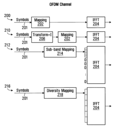
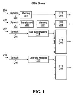
Method and system for combining OFDM and transformed OFDM
PatentActiveUS7929407B2
Innovation
- The method involves adaptive switching between OFDM and Transformed OFDM (T-OFDM) multiplexing, using distinct or common frequency resources across multiple antennas, and employing transform functions like FFT, Hadamard, or wavelet transforms to optimize transmission characteristics based on SNR, traffic type, and power amplifier headroom.
Detection of interferers using divergence of signal quality estimates
PatentInactiveUS20090180521A1
Innovation
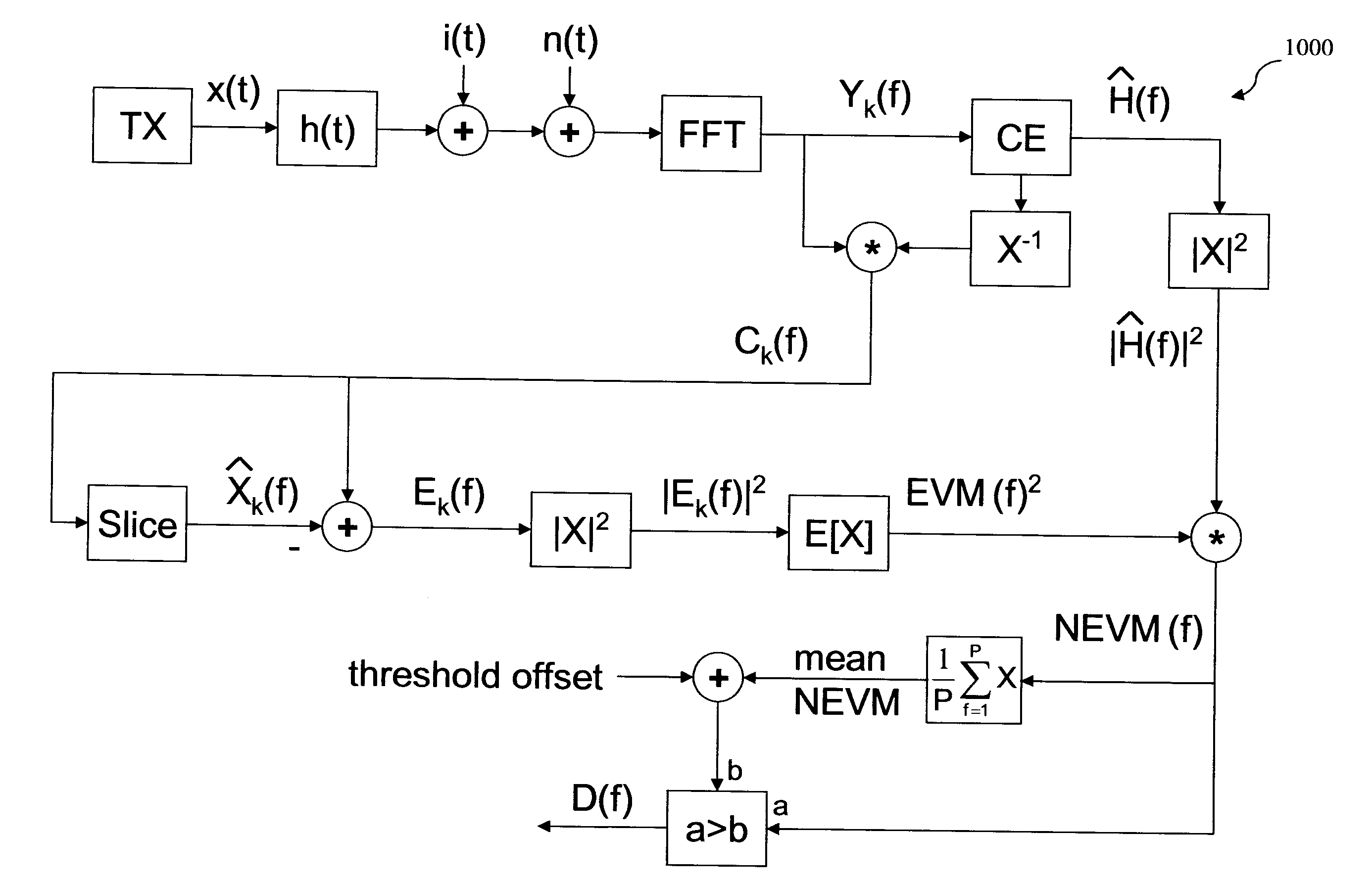
- A method and system that utilize signal quality metrics such as error vector magnitude (EVM) and channel response (CR) to detect interferers by identifying discrepancies in their behavior, with a detection module in an OFDM receiver subsystem that compares normalization values exceeding a threshold to identify interferers and suppress affected sub-carriers, enabling effective interference avoidance.
Spectrum Allocation and Regulatory Framework for Sensing Systems
The regulatory landscape governing spectrum allocation for OFDM-based remote sensing systems presents a complex framework that varies significantly across global jurisdictions. In the United States, the Federal Communications Commission (FCC) allocates specific frequency bands for sensing applications, with particular emphasis on the L-band (1-2 GHz), C-band (4-8 GHz), and X-band (8-12 GHz) ranges where OFDM remote sensing systems commonly operate. These allocations must carefully balance the needs of remote sensing with existing telecommunications services to prevent harmful interference.
The International Telecommunication Union (ITU) plays a crucial role in coordinating global spectrum usage through the Radio Regulations framework, which is updated every three to four years at World Radiocommunication Conferences. For OFDM-based geospatial systems, adherence to ITU-R recommendations is essential, particularly those addressing bandwidth efficiency and out-of-band emissions that could affect adjacent services.
European regulatory frameworks, administered by the European Conference of Postal and Telecommunications Administrations (CEPT), have established dedicated spectrum allocations for Earth observation services that utilize OFDM modulation. These frameworks typically impose stricter power limitations compared to their North American counterparts, reflecting Europe's denser population distribution and greater potential for service interference.
Licensing requirements for OFDM sensing systems vary by application type and operational parameters. Commercial remote sensing operations generally require specific authorization, while research applications may operate under experimental licenses with limited timeframes. The licensing process typically evaluates factors including transmission power, duty cycle, geographic coverage area, and potential interference with existing services.
Emerging regulatory trends indicate a move toward dynamic spectrum access models for sensing applications, where OFDM systems could potentially operate on a secondary basis in underutilized spectrum bands. This approach is being explored in several jurisdictions as a means to increase spectrum efficiency while protecting primary users. Cognitive radio techniques combined with OFDM flexibility offer promising solutions for implementing these dynamic access models.
International coordination remains a significant challenge for OFDM remote sensing deployments that operate across borders. Bilateral and multilateral agreements often supplement global frameworks to address specific regional concerns. The development of standardized interference mitigation techniques for OFDM sensing systems has become a priority area for international regulatory bodies seeking to facilitate wider deployment while maintaining spectrum harmony.
Environmental Impact Assessment of OFDM Remote Sensing Technologies
The deployment of OFDM (Orthogonal Frequency Division Multiplexing) technologies in remote sensing applications presents significant environmental considerations that warrant thorough assessment. These systems, while offering enhanced data collection capabilities for geospatial analysis, introduce various environmental impacts across their lifecycle that must be evaluated systematically.
Energy consumption represents a primary environmental concern with OFDM remote sensing systems. The technology's signal processing requirements demand substantial computational resources, particularly when deployed in continuous monitoring scenarios. Field studies indicate that advanced OFDM remote sensing platforms can consume between 15-30% more power than conventional single-frequency systems, though this is partially offset by improved data quality reducing the need for repeated sensing operations.
Electromagnetic radiation emissions from OFDM systems present another environmental consideration. While operating within regulatory limits, the multi-carrier nature of OFDM signals creates a more complex electromagnetic footprint than traditional sensing technologies. Recent research suggests minimal impact on wildlife behavior at standard operational power levels, though long-term studies remain limited in scope.
Physical infrastructure requirements for OFDM remote sensing networks also contribute to environmental impact profiles. The deployment of sensor arrays, transmission equipment, and data processing centers necessitates consideration of habitat disruption, particularly in sensitive ecological zones. However, the superior range capabilities of OFDM systems can reduce the overall physical footprint required for comprehensive coverage compared to legacy technologies.
Material resource utilization throughout the lifecycle of OFDM sensing equipment warrants attention in environmental assessments. The specialized components required for high-performance signal processing contain rare earth elements and precious metals with significant extraction impacts. Emerging circular economy approaches in equipment design have demonstrated potential to reduce these impacts by 20-25% through improved recyclability and component reuse strategies.
Carbon footprint calculations for OFDM remote sensing operations reveal complex trade-offs. While operational emissions may exceed traditional systems due to higher energy requirements, the enhanced analytical capabilities enable more efficient resource management in applications such as precision agriculture, forestry monitoring, and disaster response, potentially yielding net positive environmental outcomes when assessed holistically.
Noise pollution considerations, though often overlooked, represent another environmental dimension of OFDM sensing technologies. The acoustic signature of deployment platforms, particularly in aerial and marine applications, requires evaluation against baseline environmental conditions to minimize disruption to sensitive species and habitats.
Unlock deeper insights with Patsnap Eureka Quick Research — get a full tech report to explore trends and direct your research. Try now!
Generate Your Research Report Instantly with AI Agent
Supercharge your innovation with Patsnap Eureka AI Agent Platform!