
Dynamic analysis system and method for sign photometric performance
An analysis system and marking technology, which is applied in the direction of testing optical performance, etc., can solve problems such as potential safety hazards, low efficiency, and potential safety hazards for personnel, and achieve clear collection, avoid manual calculation and analysis, and improve analysis efficiency and accuracy.
Patent Information
- Authority / Receiving Office
- CN · China
- Current Assignee / Owner
- Publication Date
- 2013-03-27
- Estimated Expiration
- Not applicable · inactive patent
Smart Images
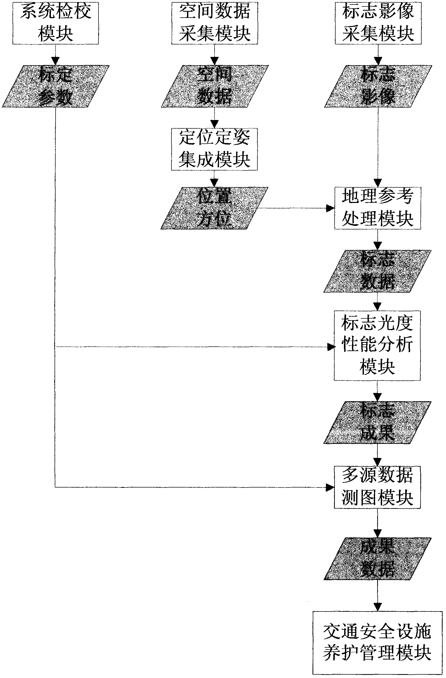
Figure 1
Abstract
Description
technical field
[0001] The invention relates to a road traffic analysis system and a method thereof, in particular to a dynamic analysis system and a method for the photometric performance of signs. Background technique
[0002] At present, there are no methods and products on the market that can dynamically test and analyze the photometric performance of signs, and the photometric performance of signs is an important test item in the maintenance and management of road traffic signs, and its performance is directly related to the visibility of signs when drivers are driving on the road At present, it is generally used by inspectors to use hand-held instruments to touch the surface of the sign board through the lift car for testing. Low, there is a problem of personnel safety hazards. Contents of the invention
[0003] The invention provides a dynamic analysis system and method for detecting and analyzing the photometric performance of road traffic signs.
[0004] Realize...
Examples
Embodiment Construction
[0024] Such as figure 1 Shown, a kind of dynamic analysis system of marking photometric performance of the present invention comprises:
[0025] A system calibration module: the measurement parameters of the calibration system are mainly the internal parameters (principal point, principal distance, distortion coefficient) and external parameters (position relative to the center of GPS and attitude relative to IMU) of the area array camera;
[0026] A spatial data acquisition module: collect GPS, IMU and mileage data;
[0027] A sign image acquisition module: collect data from two black-and-white near-infrared area array cameras, and the data format is a large file format;
[0028] A positioning and attitude determination integration module: import GPS, IMU and mileage data to generate the vehicle body running position (plane and elevation coordinates) and attitude data (heading angle, pitch angle, roll angle);
[0029] A geographic reference processing module: generate geogr...