
Land cover classification method based on MODIS time series data
A time-series and land-covering technology, applied to instruments, character and pattern recognition, computer components, etc., can solve the problems of reduced accuracy of SG reconstruction results, time-consuming, negative deviation of vegetation index, etc.
Patent Information
- Authority / Receiving Office
- CN · China
- Patent Type
- Applications(China)
- Current Assignee / Owner
- Publication Date
- 2015-01-28
- Estimated Expiration
- Not applicable · inactive patent
Smart Images
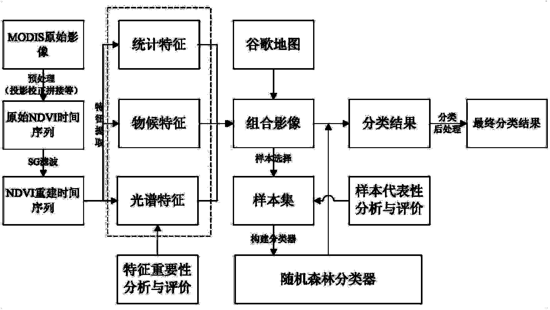
Figure 1 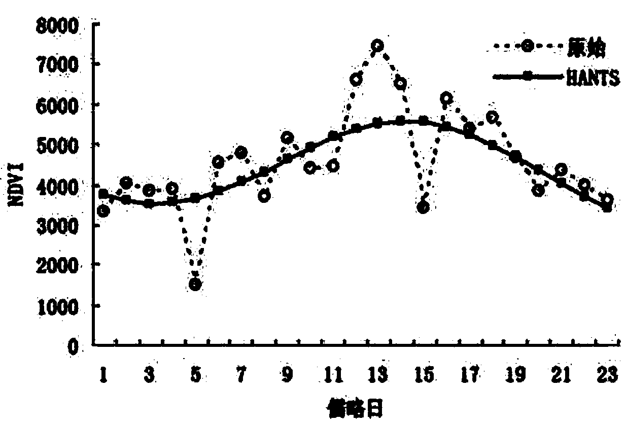
Figure 2 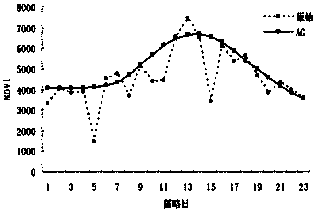
Figure 3
Abstract
Description
technical field
[0001] The present invention relates to the field of land cover, in particular to the field of land cover classification methods based on MODIS time series data; Background technique
[0002] At present, the combination of data statistics theory and manual interpretation is still the dominant method for remote sensing classification in large scales. Obviously, this method has the characteristics of mature algorithm and full use of human-computer interaction and influence. However, it takes a long time, is highly dependent on the personnel involved in interpretation and analysis, and is not repeatable to a large extent. These limitations affect the rapid, accurate and objective acquisition of large-scale land cover type information.
[0003] Although SG (Savitzky and Golay's filtering method) objectively reflects the normalized difference vegetation index (NDVI) value of the real ground objects to a certain extent during the fitting process, there are still t...
Examples
specific Embodiment approach 1
[0037] Specific embodiment one: a kind of land cover classification method based on MODIS time series data of the present embodiment is specifically prepared according to the following steps:
[0038] Step 1. Set the cloud-free image in the original MODIS NDVI time-series image of the year as n+1 scene, the Julian day is X, and the NDVI value is Y, and a two-dimensional array (of the cloud-free image) is established as (X 0 , Y 0 ), (X 1 , Y 1 ),…(X n , Y n ) is the original curve;
[0039] Step 2: Use the VI quality evaluation data QA in the C5 scientific data set to set the weight of the corresponding pixel, and use the weight to filter and fit the original curve to the initial curve using the SG method; among them, the C5 fifth-generation MODIS plant index scientific data set ; The full name of SG is the Savitzky-Golay smoothing filter;
[0040] Step 3, the cloud-free image of a pixel of the initial curve is set as n+1 scenes, the Julian day is x, and the NDVI value ...
specific Embodiment approach 2
[0056] Specific embodiment 2: The difference between this embodiment and specific embodiment 1 is that in step 2, the weight of the VI quality evaluation data QA in the C5 scientific data set is 0-3 for the overall quality evaluation, and the weight of the corresponding pixel value is set to 100. %, 60%, 20% and 0, if the quality rating is 0, the weight is 100%; if the quality rating is 1, the weight is 60%; if the quality rating is 2, the weight is 20%; if the quality rating is 3, the weight is 0%. Other steps and parameters are the same as those in Embodiment 1.
specific Embodiment approach 3
[0057] Specific embodiment three: the difference between this embodiment and specific embodiment one or two is: in step six, the B-spline curve expression is
[0058] C ( u ) = Σ i = 0 n P i N i , k ( u ) - - - ( 1 )
[0059] Among them, P i is the frequency of the number of samples belonging to class i at node N to the total number of samples; N i,k (u) is a harmonic function, also known as a basis function, which can be defined according to the recursive formula:
[0060]
[0061] N i , k ...