
GPS data based automatic construction method and system for open-pit mine road network
A GPS data, automatic construction technology, applied in the direction of image data processing, 2D image generation, instruments, etc., can solve the problems of poor accuracy, inapplicability, frequent changes of mine road network, etc., to ensure safe, automatic and accurate construction Effect
Patent Information
- Authority / Receiving Office
- CN · China
- Patent Type
- Applications(China)
- Current Assignee / Owner
- Publication Date
- 2015-11-18
Smart Images
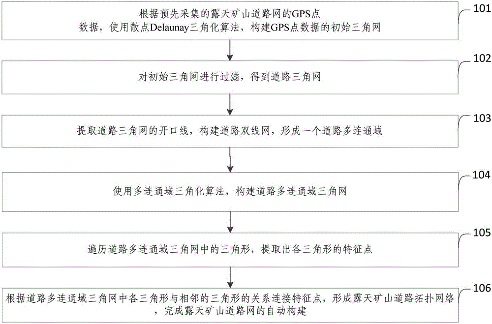
Figure 1 
Figure 2 
Figure 3
Abstract
Description
technical field
[0001] The invention relates to the field of road construction in open-pit mines, in particular to a method and system for automatically constructing road networks in open-pit mines based on GPS data. Background technique
[0002] The open-pit mine road network is a road network that truly reflects the geographical location information of the open-pit mine roads and the topological relationship between the roads. It is the basis for the open-pit mine truck dispatching system and mining equipment operation monitoring and management. With the application and development of informatization and intelligence in mines, the demand for automatic construction and rapid update of road networks in open-pit mines is increasingly urgent. Existing road network construction technologies for open-pit mines have problems such as low degree of automation, long cycle, high cost and precision. Inadequate problems, resulting in the dilemma that the construction of the open-air ro...
Examples
Embodiment Construction
[0060] In order to make the purpose, technical solutions and advantages of the embodiments of the present invention clearer, the technical solutions in the embodiments of the present invention will be clearly and completely described below in conjunction with the drawings in the embodiments of the present invention. Obviously, the described embodiments It is a part of embodiments of the present invention, but not all embodiments. Based on the embodiments of the present invention, all other embodiments obtained by persons of ordinary skill in the art without creative efforts fall within the protection scope of the present invention.
[0061] figure 1 It shows the flow chart of the method for automatically constructing the open-pit mine road network based on GPS data provided by Embodiment 1 of the present invention, see figure 1 , the method for automatically constructing the open-pit mine road network based on GPS data provided by the embodiment of the present invention inclu...