
A super-resolution high-precision low-altitude angle measurement method based on fast storage technology
A fast storage and super-resolution technology, applied in direction finders using radio waves, radio wave measurement systems, radio wave direction/deviation determination systems, etc., can solve problems such as extremely high processing capacity and large transmission bandwidth, and achieve solutions Large amount of calculation, effect of reducing the amount of input data
Patent Information
- Authority / Receiving Office
- CN · China
- Patent Type
- Patents(China)
- Current Assignee / Owner
- Publication Date
- 2019-09-24
Smart Images
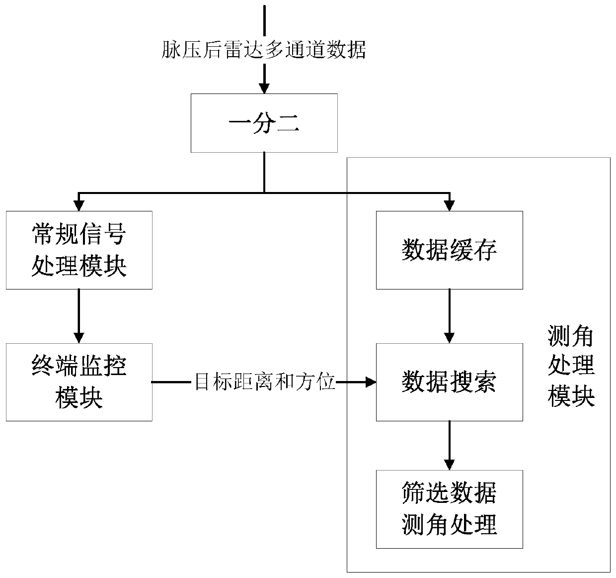
Figure 1 
Figure 2 
Figure 3
Abstract
Description
technical field
[0001] The invention belongs to the technical field of low-altitude angle measurement engineering, in particular to a super-resolution and high-precision low-altitude angle measurement method based on fast storage technology. Background technique
[0002] Due to the ground or sea reflection, the radar reflection signal and the direct signal enter the radar antenna together (after vector addition), which causes the echo signal to change in amplitude and phase, and the error caused is called multipath error. This phenomenon is It is called radar multipath effect (hereinafter referred to as multipath effect). The multipath effect causes changes in the amplitude and phase of the radar received signal, resulting in measurement and tracking errors, which may lead to loss of tracking targets in severe cases. Therefore, in order to improve the radar's measurement and tracking accuracy of low-altitude or ultra-low-altitude targets, it is necessary to solve the proble...
Examples
Embodiment Construction
[0022] The sequence of the present invention includes the step of splitting the received radar echo data into two after pulse compression processing, sending the radar echo pulse pressure signal to the back-end terminal monitoring module after conventional processing, and the terminal monitoring module giving the detection target. In the step of distance and orientation information, according to the distance and orientation information of the detected target, the corresponding distance unit data is found in the angle measurement processing module to perform the angle measurement processing step.
[0023] The present invention will be further described below in conjunction with the accompanying drawings and specific embodiments.
[0024] A specific embodiment of the present invention takes a certain type of phased array radar as an example, including the following steps:
[0025] Step 1. Perform pulse compression processing on the received radar echo data and then split them in...