
Settlement monitoring method based on D-InSAR technology and image weighted stacking
A technology of weighted superposition and subsidence monitoring, applied in the field of land subsidence monitoring of time series D-InSAR technology, can solve problems such as affecting the accuracy of monitoring results and not considering the quality weight of interferograms, so as to weaken the influence of atmospheric delay, improve monitoring accuracy, reduce The effect of data volume requirements
Patent Information
- Authority / Receiving Office
- CN · China
- Patent Type
- Applications(China)
- Current Assignee / Owner
- Publication Date
- 2021-05-28
- Estimated Expiration
- Not applicable · inactive patent
Smart Images
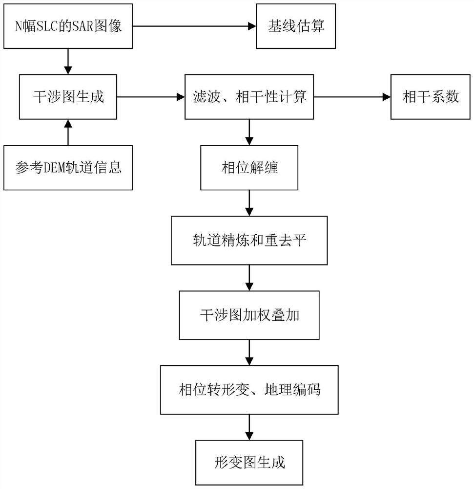
Figure 1 
Figure 2 
Figure 3
Abstract
Description
technical field
[0001] The invention belongs to the field of synthetic aperture radar interferometry, in particular to a land subsidence monitoring method of time series D-InSAR technology. Background technique
[0002] Land subsidence is a local engineering geological phenomenon that causes the elevation of the crustal surface to change slowly under the comprehensive influence of natural changes and human activities. With the continuous acceleration of global urbanization, urban expansion and rapid population growth, extensive construction of urban infrastructure and over-exploitation of underground resources have led to increasingly serious urban land subsidence. Land subsidence can cause serious damage to buildings and production facilities, which is not conducive to urban construction and resource exploration and development, and may even cause seawater intrusion in coastal areas, causing major safety hazards to people's life and property safety and infrastructure safety...
Examples
Embodiment Construction
[0029] In this embodiment, a subsidence monitoring method based on D-InSAR technology and image weighted overlay is to select multiple optimal main images, and register the remaining images with the main images, and then compare the interference generated by registration to the same main image. The image pairs screen out the interference pairs with short space-time baselines to generate different sets, and the baselines between each set are longer. The ground deformation information of each set is obtained by the least square method, and then the singular decomposition method is used to combine the sets to solve. This method can obtain higher monitoring accuracy on the basis of fewer data sets. Specifically, if figure 1 As shown, the method includes the following steps:
[0030] Step 1. Select a plurality of public main images from the SAR image database by the public main image selection method;
[0031] Step 1.1. Carry out SAR data preprocessing to 9 SAR images in the SAR ...