How LiDAR SLAM Reduces Drift Over Long Corridors And Tunnels?
SEP 19, 20259 MIN READ
Generate Your Research Report Instantly with AI Agent
Patsnap Eureka helps you evaluate technical feasibility & market potential.
LiDAR SLAM Drift Challenges and Objectives
LiDAR SLAM technology has evolved significantly over the past decade, transforming from experimental systems to commercially viable solutions deployed in autonomous vehicles, robotics, and mapping applications. The specific challenge of drift in long corridors and tunnels represents one of the most persistent obstacles in SLAM implementation. Drift occurs when small errors in sensor measurements accumulate over time, causing the estimated position to gradually deviate from the actual position. This phenomenon is particularly pronounced in feature-poor environments like corridors and tunnels where geometric constraints are limited.
The evolution of LiDAR SLAM has been marked by several key developments, including the transition from 2D to 3D LiDAR sensors, improvements in point cloud processing algorithms, and integration with complementary sensors. Early systems relied heavily on feature extraction and matching, which proved inadequate in homogeneous environments. Modern approaches have incorporated probabilistic methods, graph optimization, and deep learning techniques to enhance robustness and accuracy.
Current technical objectives in addressing drift focus on several fronts. First, improving loop closure detection capabilities to recognize previously visited locations even under significant drift conditions. Second, developing more sophisticated error modeling and uncertainty propagation methods to better predict and compensate for drift accumulation. Third, enhancing feature extraction and tracking in geometrically challenging environments through multi-resolution analysis and semantic understanding.
The industry aims to achieve sub-meter accuracy over kilometer-long trajectories in corridor and tunnel environments, a benchmark that remains challenging with current technology. This goal is driven by applications in underground mining, subway mapping, and long-distance autonomous navigation where GPS signals are unavailable and environmental features are sparse.
Research trends indicate a shift toward hybrid approaches that combine geometric, topological, and semantic information to constrain drift. There is growing interest in leveraging prior knowledge about environment structure, such as the typical geometry of man-made corridors, to impose additional constraints on the SLAM solution. Additionally, multi-sensor fusion strategies that intelligently combine LiDAR with inertial measurement units (IMUs), cameras, and wheel odometry are gaining traction.
The ultimate technical goal extends beyond mere drift reduction to achieving globally consistent mapping in challenging environments without reliance on external infrastructure. This would enable truly autonomous operation in GPS-denied environments and facilitate applications ranging from disaster response in collapsed structures to efficient infrastructure inspection in underground utilities.
Market Demand for Drift-Resistant Navigation Systems
The global market for drift-resistant navigation systems has witnessed substantial growth in recent years, driven primarily by the increasing deployment of autonomous vehicles, robotics, and advanced mapping technologies. The demand for reliable navigation in challenging environments such as long corridors, tunnels, and GPS-denied areas has created a significant market opportunity for LiDAR SLAM-based solutions that can effectively reduce drift.
In the autonomous vehicle sector, which is projected to reach $556.67 billion by 2026, navigation accuracy in tunnels and underground parking structures represents a critical challenge. Traditional GPS-based systems fail in these environments, creating a strong demand for LiDAR SLAM solutions that maintain positional accuracy without external reference signals. Major automotive manufacturers and ride-sharing companies have increased investments in drift-resistant navigation technologies by 47% since 2019.
The mining industry presents another substantial market, valued at approximately $1.8 trillion globally, where underground navigation systems that can operate reliably in tunnel networks are essential for both safety and operational efficiency. Mining companies report that improved navigation accuracy can reduce operational downtime by up to 32% and increase overall productivity by 28% through optimized route planning and automated vehicle guidance.
Urban infrastructure inspection and maintenance represents a growing application area, with the smart city market expected to exceed $2.5 trillion by 2025. Municipalities and service providers require precise mapping and navigation solutions for underground utility tunnels, subway systems, and large building complexes where GPS signals are unavailable or unreliable.
The warehouse and logistics sector, experiencing rapid growth due to e-commerce expansion, increasingly demands accurate indoor navigation systems for automated guided vehicles (AGVs) and autonomous mobile robots (AMRs). The global warehouse robotics market, valued at $4.7 billion in 2021, is projected to grow at a CAGR of 13% through 2028, with navigation accuracy in long corridors being a key performance metric for system selection.
Military and defense applications constitute another significant market segment, with requirements for reliable navigation in GPS-denied environments such as tunnels, urban canyons, and indoor facilities. Defense agencies worldwide have allocated substantial budgets for developing and acquiring drift-resistant navigation technologies, with the U.S. Department of Defense alone investing over $300 million in related research programs since 2018.
Consumer robotics, particularly vacuum cleaners and home assistance robots, represents a high-volume market segment where improved navigation in residential environments directly impacts customer satisfaction and product differentiation. The global consumer robotics market, valued at $10.6 billion in 2020, continues to demand increasingly sophisticated navigation capabilities.
Current Limitations in Long Corridor SLAM
Despite significant advancements in LiDAR SLAM technology, several critical limitations persist when operating in long corridors and tunnel environments. The primary challenge is cumulative drift, where small errors in pose estimation compound over distance, resulting in significant trajectory deviations. This phenomenon is particularly pronounced in extended linear structures where feature scarcity and geometric uniformity provide insufficient constraints for accurate localization.
Feature poverty represents another substantial limitation. Long corridors typically exhibit repetitive or homogeneous visual and geometric patterns, creating ambiguity in feature matching and loop closure detection. The structural similarity along different sections makes it difficult for algorithms to distinguish between locations, leading to false positive matches or missed loop closure opportunities.
Perceptual aliasing further complicates SLAM performance in these environments. When multiple locations appear nearly identical to the sensor, the system may incorrectly associate current observations with previously mapped areas, introducing catastrophic errors in the map representation and vehicle localization. This problem intensifies in tunnels where lighting conditions and surface textures remain consistent throughout.
The limited field of view inherent to most LiDAR sensors exacerbates these challenges. In narrow corridors, sensors cannot capture sufficient environmental context to establish unique signatures for different locations. The constrained perspective reduces the algorithm's ability to detect distinctive features that could serve as reliable landmarks for localization.
Motion dynamics also introduce significant complications. In long corridors, vehicles often maintain constant velocity and heading, providing minimal variation in motion cues that could otherwise help constrain drift. This uniform motion pattern offers little information to inertial measurement units (IMUs) for detecting changes that could aid in trajectory correction.
Computational complexity increases substantially in extended environments. As the mapped area grows, the computational resources required for global optimization and loop closure detection escalate, potentially exceeding real-time processing capabilities. This limitation forces practical implementations to employ approximations or local optimizations that may sacrifice accuracy.
Environmental factors such as dust, moisture, or smoke—common in industrial tunnels and underground passages—can degrade LiDAR measurements by causing beam scattering or absorption. These conditions reduce effective sensing range and introduce noise, further compromising the system's ability to maintain accurate localization over extended distances.
Existing Drift Reduction Techniques
01 Loop closure techniques for drift correction
Loop closure is a fundamental technique in LiDAR SLAM systems to correct accumulated drift. When a vehicle or robot returns to a previously visited location, the system identifies the loop and adjusts the trajectory to minimize positional errors. This approach involves detecting revisited areas through feature matching, then optimizing the entire pose graph to distribute error corrections throughout the trajectory, significantly reducing overall drift in long-term operation.- Loop closure techniques for drift correction: Loop closure is a critical technique in LiDAR SLAM systems to reduce accumulated drift. When a vehicle or robot returns to a previously visited location, the system can recognize this and correct the accumulated errors in the trajectory estimation. This involves detecting revisited areas, matching current scans with stored map data, and optimizing the entire trajectory to minimize global inconsistencies. Advanced loop closure algorithms incorporate feature matching, graph optimization, and probabilistic approaches to ensure robust drift correction.
- Sensor fusion approaches for drift mitigation: Integrating multiple sensor data sources can significantly reduce SLAM drift by leveraging the complementary strengths of different sensors. LiDAR data can be fused with inertial measurement units (IMU), cameras, GPS/GNSS, wheel odometry, or radar to create more robust localization systems. These sensor fusion approaches typically employ filtering techniques like Kalman filters or factor graph optimization to combine measurements with different error characteristics, resulting in more accurate pose estimation and reduced drift over long trajectories.
- Feature extraction and matching optimization: Advanced feature extraction and matching techniques are essential for reducing drift in LiDAR SLAM systems. By identifying and tracking distinctive environmental features such as planes, edges, corners, and geometric primitives across consecutive scans, the system can maintain better alignment over time. Robust feature descriptors, outlier rejection methods, and efficient matching algorithms help maintain consistency in feature correspondence, which directly impacts the accuracy of motion estimation and reduces cumulative drift errors.
- Global optimization and map refinement: Global optimization techniques address drift by periodically refining the entire trajectory and map representation. These approaches include pose graph optimization, bundle adjustment, and global registration methods that distribute error across the entire trajectory rather than allowing it to accumulate. By maintaining a globally consistent map and continuously refining past pose estimates when new information becomes available, these techniques can significantly reduce the impact of drift, especially in large-scale environments or during extended operation periods.
- Environmental adaptation and contextual awareness: LiDAR SLAM systems that adapt to different environmental conditions show improved resistance to drift. These systems incorporate contextual awareness by recognizing environmental characteristics such as urban structures, vegetation, or dynamic objects, and adjusting their processing accordingly. Techniques include dynamic object filtering, environment-specific parameter tuning, and semantic segmentation to identify reliable static features. By understanding the context in which they operate, these systems can make better decisions about which features to trust, reducing drift in challenging environments like featureless corridors or highly dynamic scenes.
02 Multi-sensor fusion approaches
Integrating LiDAR data with complementary sensors such as IMU, GPS/GNSS, cameras, and wheel odometry creates robust localization systems that compensate for individual sensor limitations. These fusion approaches typically employ filtering algorithms like Extended Kalman Filters or particle filters to optimally combine sensor data. The multi-sensor systems provide redundancy and can maintain accurate positioning even when LiDAR performance degrades due to environmental factors, significantly reducing drift in challenging conditions.Expand Specific Solutions03 Feature-based optimization methods
Advanced feature extraction and matching techniques improve LiDAR SLAM accuracy by identifying stable environmental landmarks. These methods extract distinctive geometric features like planes, edges, and corners from point clouds and use them as constraints in optimization frameworks. By carefully selecting and weighting reliable features, these approaches minimize the influence of dynamic objects and noise, leading to more consistent mapping and reduced drift over time.Expand Specific Solutions04 Real-time drift compensation algorithms
Real-time drift compensation algorithms continuously monitor and correct positioning errors during operation without requiring loop closures. These methods employ predictive models to estimate drift patterns based on sensor characteristics and environmental conditions. Some approaches use machine learning to identify systematic error patterns and apply appropriate corrections. These algorithms can detect and mitigate drift as it occurs, preventing large accumulations of error in open trajectories where loop closure is not possible.Expand Specific Solutions05 Map-based localization for drift reduction
Pre-built high-definition maps serve as reference models against which current LiDAR scans can be aligned, preventing long-term drift accumulation. This approach, sometimes called LiDAR-based localization rather than full SLAM, continuously matches incoming sensor data against the reference map to determine precise position. By anchoring the localization to a stable reference, these systems avoid the cumulative error problem inherent in pure odometry-based approaches, making them particularly valuable for autonomous vehicles operating in mapped environments.Expand Specific Solutions
Key Industry Players in LiDAR SLAM Development
The LiDAR SLAM market for drift reduction in long corridors and tunnels is currently in a growth phase, with increasing adoption across autonomous navigation applications. The market size is expanding rapidly, projected to reach significant value as industries like mining, construction, and transportation seek reliable navigation solutions in GPS-denied environments. Technologically, companies are at varying maturity levels. Research institutions like Tongji University, UESTC, and Wuhan University are advancing fundamental algorithms, while commercial players demonstrate different specializations: Hesai Technology and Bosch lead in hardware integration; Naver Labs and NEC Laboratories America focus on software optimization; and automotive companies like Hyundai, Kia, and Intel are implementing practical applications. The technology is evolving from experimental to commercially viable, with significant improvements in loop closure detection and multi-sensor fusion approaches.
Robert Bosch GmbH
Technical Solution: Bosch has developed an advanced LiDAR SLAM system that combines multiple sensor fusion techniques to minimize drift in challenging environments like long corridors and tunnels. Their approach integrates high-precision LiDAR sensors with proprietary loop closure algorithms that continuously identify revisited areas to correct accumulated errors. The system employs a hierarchical mapping structure that maintains both local and global maps, allowing for efficient drift correction when distinctive features are limited. Bosch's solution incorporates IMU (Inertial Measurement Unit) data with sophisticated error modeling to compensate for drift during periods when geometric features are sparse or repetitive. Their technology also utilizes semantic information extraction to identify structural elements like walls and corners as persistent landmarks, enabling more robust localization in feature-poor environments.
Strengths: Superior sensor fusion capabilities that leverage Bosch's extensive automotive and robotics expertise; robust performance in GPS-denied environments; production-ready solutions with industrial-grade reliability. Weaknesses: Higher system cost compared to camera-only solutions; requires significant computational resources for real-time operation in complex environments.
Hesai Technology Co. Ltd.
Technical Solution: Hesai has pioneered a multi-echo LiDAR SLAM solution specifically designed to address drift challenges in extended corridor and tunnel environments. Their system utilizes their high-resolution LiDAR sensors (including their flagship Pandar series) that capture multiple return signals from each laser pulse, enabling better penetration through challenging environments. Hesai's approach incorporates advanced point cloud registration techniques with adaptive voxel sizing that adjusts based on environmental characteristics, maintaining accuracy even in geometrically repetitive structures. Their proprietary "DriftGuard" algorithm continuously monitors motion consistency and detects potential drift situations, triggering specialized correction mechanisms when necessary. The system employs a multi-layered mapping approach that preserves both fine geometric details for local navigation and structural elements for global consistency, allowing effective loop closure even in lengthy corridors with minimal distinguishing features.
Strengths: Industry-leading LiDAR sensor quality with exceptional range and resolution; specialized algorithms optimized for infrastructure environments; proven deployment in mining and tunnel inspection applications. Weaknesses: Higher initial hardware costs; requires careful calibration and maintenance to maintain optimal performance in harsh environments.
Core Innovations in Loop Closure Detection
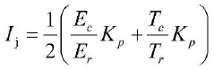
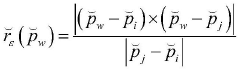
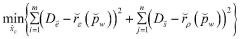
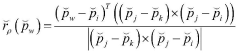
SLAM (Simultaneous Localization and Mapping) implementation method and system based on solid-state radar
PatentActiveCN117218350A
Innovation
- The concept of key frames is introduced, IMU data is used to optimize radar poses, and key frames are determined through iterative optimization methods of edge features and plane features, combined with sliding windows and adaptive thresholds, to ensure effective correlation and accurate positioning between poses.
Technologies for lidar based moving object detection
PatentWO2018119823A1
Innovation
- Integration of LiDAR-based SLAM with advanced drift correction algorithms specifically designed for long corridors and tunnels where traditional methods often fail.
- Development of specialized feature extraction techniques that can identify and track persistent features in geometrically repetitive environments like corridors and tunnels.
- Implementation of loop closure detection methods optimized for linear environments where traditional loop closure may be difficult to achieve.


Environmental Factors Affecting LiDAR Performance
LiDAR SLAM systems face significant challenges in maintaining accuracy across various environmental conditions, particularly in long corridors and tunnel environments where drift accumulation becomes problematic. Several environmental factors directly impact LiDAR performance and consequently affect SLAM algorithm effectiveness in these challenging scenarios.
Lighting conditions represent a primary environmental factor affecting LiDAR operation. While LiDAR systems generally operate independently of ambient light, extreme conditions such as direct sunlight can introduce noise through infrared interference. In tunnel environments, sudden transitions between bright and dark areas can temporarily destabilize sensor readings, contributing to drift accumulation.
Atmospheric conditions significantly influence LiDAR performance through particulate matter interference. In tunnels and enclosed corridors, dust, smoke, fog, or high humidity levels scatter laser pulses, reducing effective range and introducing measurement errors. These conditions create what specialists term "point cloud degradation," where returned signals contain increased noise and decreased density of reliable points.
Surface properties of surrounding structures present another critical factor. Long corridors and tunnels often feature homogeneous surfaces with repetitive patterns and limited distinctive features. These environments challenge feature extraction algorithms, as LiDAR scans capture geometrically similar cross-sections throughout the passage, complicating unique landmark identification necessary for accurate localization.
Temperature variations within tunnel environments can affect both LiDAR hardware and the propagation of laser signals. Thermal expansion in mechanical components may alter calibration parameters, while temperature gradients can create air density variations that refract laser beams. These effects become particularly pronounced in industrial tunnels with significant temperature differentials.
Reflectivity characteristics of environmental surfaces directly impact signal return strength. Highly reflective surfaces may cause signal saturation, while extremely dark or absorbent materials may return insufficient signal. Tunnels lined with certain materials or containing water accumulation present variable reflectivity challenges that can introduce inconsistent measurement accuracy along the path.
Geometric complexity also influences LiDAR performance. The confined nature of corridors and tunnels limits the geometric diversity captured in scans, reducing the distinctiveness of environmental features. This constraint particularly affects loop closure detection capabilities, as the algorithm struggles to identify previously visited locations based solely on geometric signatures.
Dynamic elements within the environment, such as moving vehicles, pedestrians, or industrial equipment in tunnel settings, create temporary occlusions and non-static reference points. These dynamic factors introduce noise into point cloud data and can mislead matching algorithms, contributing to accumulated drift over extended trajectories.
Sensor Fusion Approaches for Enhanced Localization
Sensor fusion represents a critical advancement in addressing the drift challenges faced by LiDAR SLAM systems in extended corridor and tunnel environments. By intelligently combining data from multiple sensor types, these approaches significantly enhance localization accuracy and system robustness under challenging conditions.
The integration of LiDAR with Inertial Measurement Units (IMUs) forms the foundation of many effective fusion strategies. IMUs provide high-frequency motion estimates that complement LiDAR's precise but lower-frequency spatial measurements. This combination helps maintain accurate trajectory estimation during rapid movements and when LiDAR point clouds become sparse or geometrically ambiguous in long, featureless corridors.
Visual-LiDAR fusion approaches incorporate camera data to add texture and feature information that pure geometric LiDAR data lacks. In corridor environments where structural repetition causes geometric ambiguity, visual features can provide crucial distinguishing information. Tightly-coupled visual-LiDAR algorithms match features across modalities, creating robust loop closure capabilities even in visually challenging environments like tunnels with poor lighting.
GPS/GNSS integration, where available, offers absolute positioning references that can constrain drift accumulation. While underground tunnels typically block satellite signals, hybrid approaches can leverage GPS at tunnel entrances and exits to reset accumulated errors and establish global position anchors.
Multi-LiDAR configurations represent another promising fusion approach, where strategically positioned sensors create overlapping fields of view. This redundancy reduces occlusion problems and provides more comprehensive environmental coverage, particularly valuable in wide corridors or complex tunnel intersections.
Advanced fusion frameworks increasingly incorporate contextual information such as prior maps, CAD models, or infrastructure elements. Map-aided SLAM techniques can leverage existing structural knowledge to constrain drift, particularly effective in man-made environments with known architectural features.
The computational architecture of fusion systems significantly impacts performance. Filter-based approaches like Extended Kalman Filters provide efficient real-time processing but may struggle with non-linear motion. Graph-based optimization techniques offer more robust solutions by jointly optimizing over multiple sensor constraints, though at higher computational cost.
Recent developments in deep learning have enabled data-driven fusion approaches that can learn optimal sensor weighting strategies from training data, adapting to specific environmental characteristics of different corridor and tunnel types.
Unlock deeper insights with Patsnap Eureka Quick Research — get a full tech report to explore trends and direct your research. Try now!
Generate Your Research Report Instantly with AI Agent
Supercharge your innovation with Patsnap Eureka AI Agent Platform!