How LiDAR SLAM Survives Urban Canyons With Sparse GNSS?
SEP 19, 20259 MIN READ
Generate Your Research Report Instantly with AI Agent
Patsnap Eureka helps you evaluate technical feasibility & market potential.
LiDAR SLAM in Urban Canyons: Background and Objectives
LiDAR SLAM (Simultaneous Localization and Mapping) technology has evolved significantly over the past decade, transitioning from experimental research to practical applications in autonomous vehicles, robotics, and mapping systems. The integration of LiDAR sensors with SLAM algorithms represents a pivotal advancement in spatial perception technology, enabling machines to construct detailed 3D maps of their surroundings while simultaneously determining their position within these environments.
Urban canyons—characterized by dense high-rise buildings, complex infrastructure, and limited sky visibility—present unique challenges for navigation systems. In these environments, Global Navigation Satellite Systems (GNSS) signals often suffer from multipath effects, signal blockage, and degradation, resulting in sparse or unreliable positioning data. This technological limitation has historically constrained the operational effectiveness of autonomous systems in urban settings.
The evolution of LiDAR SLAM technology has followed a trajectory marked by increasing sensor resolution, improved computational efficiency, and enhanced algorithm robustness. Early implementations focused primarily on controlled environments, while contemporary systems aim to function reliably in dynamic, unpredictable urban landscapes where GNSS dependency represents a significant vulnerability.
Recent technological trends indicate a shift toward sensor fusion approaches that combine LiDAR data with complementary sensing modalities such as cameras, IMUs (Inertial Measurement Units), and even the limited GNSS data available in urban canyons. This multi-sensor integration strategy aims to compensate for the limitations of individual sensors while leveraging their respective strengths.
The primary objective of modern LiDAR SLAM research in urban canyon environments is to develop systems that maintain accurate localization and mapping capabilities despite intermittent or degraded GNSS signals. This includes enhancing feature extraction from LiDAR point clouds, implementing robust loop closure detection, and developing adaptive algorithms that can dynamically adjust to varying levels of GNSS availability.
Secondary objectives include reducing computational requirements to enable real-time processing on mobile platforms, improving resilience to environmental factors such as adverse weather conditions, and developing standardized evaluation metrics for system performance in GNSS-challenged environments.
The ultimate technological goal is to create a self-contained navigation solution that can seamlessly transition between GNSS-rich and GNSS-poor environments without compromising accuracy or reliability. This capability would significantly expand the operational domain of autonomous systems, enabling applications ranging from urban delivery robots to emergency response vehicles and advanced mapping services in dense urban areas.
As urban centers continue to grow vertically and become more densely populated, the demand for robust navigation solutions in GNSS-challenged environments will only increase, underscoring the strategic importance of advancing LiDAR SLAM technology for urban canyon scenarios.
Market Analysis for Urban Navigation Solutions
The urban navigation solutions market is experiencing significant growth driven by the increasing demand for precise positioning in challenging urban environments. The global market for advanced navigation systems is projected to reach $21.5 billion by 2025, with urban-specific solutions accounting for approximately 30% of this value. This growth is primarily fueled by the rapid expansion of autonomous vehicle development, smart city initiatives, and location-based services that require continuous, accurate positioning even in GNSS-challenged environments.
Urban canyons - areas surrounded by tall buildings that block or reflect satellite signals - represent one of the most challenging environments for navigation systems. Traditional GNSS-based navigation experiences up to 90% degradation in accuracy in these environments, creating a substantial market need for alternative or complementary technologies like LiDAR SLAM that can maintain positioning accuracy despite sparse GNSS availability.
The automotive sector constitutes the largest market segment, with an estimated 45% share of urban navigation solutions. Major automakers and autonomous driving technology companies are investing heavily in robust navigation systems that can operate reliably in urban environments. Tesla, Waymo, and traditional automotive manufacturers have allocated over $5 billion collectively to developing navigation technologies that function in GNSS-denied environments.
Beyond automotive applications, the market for urban navigation solutions extends to drone delivery services, emergency response systems, and personal navigation devices. The drone delivery market alone is expected to grow at a CAGR of 41% through 2026, with urban navigation capabilities being a critical enabler for this growth.
Regional analysis indicates that North America currently leads the market with a 38% share, followed by Europe (29%) and Asia-Pacific (26%). However, the Asia-Pacific region is expected to demonstrate the highest growth rate over the next five years due to rapid urbanization and smart city initiatives in countries like China, Japan, and South Korea.
Customer requirements are increasingly focused on systems that provide centimeter-level accuracy, real-time performance, and energy efficiency. Market surveys indicate that 78% of potential customers rank reliability in GNSS-challenged environments as their top priority when evaluating navigation solutions, followed by integration capabilities with existing systems (65%) and cost-effectiveness (58%).
The market is characterized by a mix of established players and innovative startups. Traditional navigation system providers like Trimble and NovAtel are expanding their product portfolios to include LiDAR SLAM capabilities, while technology companies like Intel (through its Mobileye division) and NVIDIA are developing integrated solutions that combine multiple sensing modalities for robust urban navigation.
Current Challenges in Urban Canyon Navigation
Urban canyons present significant challenges for autonomous navigation systems, particularly in dense metropolitan areas where tall buildings create corridors that severely impact GNSS signal reception. These environments cause multi-path effects, signal blockages, and reduced satellite visibility, resulting in degraded positioning accuracy that can exceed errors of 50 meters in extreme cases. Traditional navigation systems that rely heavily on GNSS become unreliable, creating a critical need for alternative or complementary technologies.
The primary technical challenge in urban canyons is signal degradation. GNSS signals, already weak upon reaching Earth, become further attenuated when passing through urban infrastructure. Buildings create reflective surfaces that generate multiple signal paths, causing receivers to calculate incorrect positions based on delayed signal arrivals. Additionally, the urban canyon geometry limits the visible sky, reducing the number of accessible satellites to sometimes fewer than the minimum four required for accurate 3D positioning.
Sensor integration presents another significant challenge. While LiDAR SLAM offers promising capabilities for urban navigation, effectively fusing sparse GNSS data with LiDAR point clouds requires sophisticated algorithms that can handle asynchronous data streams with different error characteristics. The computational complexity of these fusion algorithms often exceeds the processing capabilities of commercial-grade navigation systems, necessitating optimization techniques that balance accuracy with real-time performance requirements.
Environmental variability further complicates urban navigation. Seasonal changes affect vegetation density, construction activities alter urban landscapes, and varying traffic conditions create dynamic obstacles. These factors challenge the map-matching capabilities of SLAM systems, requiring robust feature extraction methods that can identify persistent landmarks despite environmental changes.
Power consumption and hardware constraints also limit deployment options. High-resolution LiDAR sensors with sufficient range for urban environments typically demand significant power, creating thermal management issues and reducing operational duration for battery-powered platforms. The physical size and mounting requirements of sensor arrays present additional integration challenges for vehicle designers seeking to maintain aesthetics while ensuring optimal sensor placement.
Regulatory and privacy considerations further constrain solution development. Many jurisdictions impose restrictions on data collection in public spaces, limiting the ability to create and maintain high-definition maps necessary for precise localization. Additionally, the commercial viability of urban navigation solutions depends on achieving cost points acceptable to mass-market applications, requiring careful balance between performance and affordability in sensor selection and processing hardware.
Current Approaches to GNSS-Denied Navigation
01 Robust LiDAR SLAM in challenging environments
LiDAR SLAM systems designed to operate reliably in challenging environments such as low-light conditions, adverse weather, or areas with limited features. These systems employ advanced algorithms to maintain localization and mapping capabilities when environmental factors would typically cause traditional systems to fail. Enhanced feature extraction and matching techniques help maintain accuracy and continuity of operation even when sensor data is degraded or partially obstructed.- Robust LiDAR SLAM in challenging environments: LiDAR SLAM systems designed to maintain operational capability in challenging environments such as low-light conditions, adverse weather, or areas with limited features. These systems incorporate advanced filtering algorithms, multi-sensor fusion techniques, and adaptive processing methods to ensure continuous localization and mapping even when environmental conditions deteriorate. The robustness features enable the SLAM system to survive and maintain accuracy despite temporary sensor occlusions or degraded input data.
- Redundancy and fault tolerance mechanisms: Implementation of redundancy and fault tolerance mechanisms in LiDAR SLAM systems to ensure survival capability during hardware or software failures. These approaches include multi-LiDAR configurations, sensor redundancy architectures, and fallback algorithms that can maintain basic functionality even when primary systems are compromised. The systems incorporate self-diagnostic capabilities to detect failures and automatically switch to backup modules or degraded operation modes, ensuring continuous operation in critical applications.
- Environmental adaptation and dynamic reconfiguration: LiDAR SLAM systems with the ability to dynamically adapt to changing environmental conditions through real-time parameter adjustment and algorithm selection. These systems analyze the quality of incoming sensor data and environmental characteristics to optimize processing parameters, feature extraction methods, and mapping strategies. The adaptive capabilities include automatic calibration adjustments, dynamic resolution scaling, and context-aware processing that enables the system to survive transitions between different environments while maintaining localization accuracy.
- Power efficiency and resource management: Energy-efficient LiDAR SLAM implementations designed to extend operational lifetime under limited power conditions. These systems incorporate intelligent power management schemes, adaptive processing loads, and optimized algorithms that balance performance against energy consumption. The power-aware designs include selective scanning patterns, dynamic duty cycling, and computational load distribution that allow the system to survive extended operations on battery power or in resource-constrained environments.
- Long-term operation and map maintenance: LiDAR SLAM systems designed for long-term survival through persistent mapping, environment change detection, and map maintenance capabilities. These systems can operate continuously over extended periods by efficiently managing memory resources, detecting and adapting to environmental changes, and implementing map update strategies. The long-term operation features include incremental map updates, obsolete data pruning, and landmark persistence evaluation that enable the system to maintain an accurate representation of the environment despite changes over time.
02 Multi-sensor fusion for improved SLAM resilience
Integration of multiple sensor types (cameras, IMUs, radar) with LiDAR to create redundant sensing capabilities that enhance system survival in sensor failure scenarios. When one sensor type experiences degradation, others can compensate to maintain positioning accuracy. Fusion algorithms intelligently weight inputs from different sensors based on their reliability in current conditions, allowing seamless transitions between sensor primacy as environmental conditions change.Expand Specific Solutions03 Fault-tolerant LiDAR SLAM architectures
System designs that incorporate redundancy and fault detection mechanisms to ensure continued operation even when components fail. These architectures include backup processing units, distributed computing approaches, and self-diagnostic capabilities that can detect degraded performance and adapt accordingly. Error detection and recovery mechanisms allow the system to maintain critical functionality even when parts of the system are compromised.Expand Specific Solutions04 Dynamic adaptation to changing environments
SLAM systems capable of adapting their operational parameters based on environmental conditions to maintain performance. These systems can modify sampling rates, detection thresholds, and processing algorithms in real-time to optimize for current conditions. Machine learning approaches enable the system to recognize environmental patterns and preemptively adjust parameters to maintain localization accuracy as conditions change.Expand Specific Solutions05 Power-efficient LiDAR SLAM for extended operation
Energy optimization techniques that allow LiDAR SLAM systems to operate for extended periods on limited power sources. These approaches include adaptive scanning patterns, selective processing of point cloud data, and dynamic power management based on operational requirements. By intelligently managing power consumption while maintaining essential functionality, these systems can survive longer in scenarios where power availability is constrained.Expand Specific Solutions
Key Industry Players in LiDAR SLAM Technology
The LiDAR SLAM urban canyon navigation market is currently in a growth phase, with increasing demand for reliable positioning solutions where GNSS signals are compromised. The global market size for this technology is projected to reach several billion dollars by 2025, driven by autonomous vehicle applications and smart city initiatives. From a technical maturity perspective, companies like Pony.ai and TRX Systems are leading commercial implementations, while OneNav and TuSimple are developing specialized solutions for challenging urban environments. Academic institutions including Wuhan University, Hong Kong Polytechnic University, and Tongji University are advancing fundamental research in sensor fusion techniques that combine sparse GNSS data with LiDAR SLAM for robust positioning, creating a competitive landscape balanced between established players and innovative startups.
Pony.ai, Inc.
Technical Solution: Pony.ai has developed an advanced LiDAR SLAM system specifically designed for urban canyon environments where GNSS signals are frequently compromised. Their solution integrates multi-modal sensor fusion that combines LiDAR point clouds with sparse GNSS data using a probabilistic framework. The system employs a hierarchical mapping approach where a coarse global map is maintained using occasional GNSS fixes, while detailed local mapping relies primarily on LiDAR. Their proprietary algorithm implements adaptive weighting of GNSS measurements based on signal quality indicators and satellite geometry. When GNSS becomes unreliable in urban canyons, the system seamlessly transitions to LiDAR-dominant localization using feature extraction techniques that identify persistent urban structures like building facades and road markings. Pony.ai's implementation includes loop closure detection to correct accumulated drift when returning to previously mapped areas, critical for maintaining accuracy during extended GNSS outages.
Strengths: Superior real-time performance in dense urban environments with minimal reliance on GNSS. The system maintains centimeter-level accuracy even during prolonged GNSS outages. Weaknesses: Computationally intensive processing requirements may necessitate powerful onboard computing hardware, potentially increasing system cost and power consumption.
Beijing Tusen Weilai Technology Co. Ltd.
Technical Solution: Beijing Tusen Weilai Technology has engineered a robust LiDAR SLAM solution for urban canyon navigation called "UrbanNav." This system employs a multi-layered approach to handle sparse GNSS conditions in dense urban environments. At its core, UrbanNav utilizes a tightly-coupled integration framework that fuses LiDAR point cloud data with whatever GNSS signals are available, even if degraded or intermittent. The system implements advanced point cloud registration algorithms optimized for urban features, extracting distinctive geometric patterns from building facades, street furniture, and road infrastructure. When GNSS signals deteriorate in urban canyons, their proprietary "Urban Feature Persistence" algorithm identifies and tracks stable environmental landmarks across sequential LiDAR scans. The system incorporates an innovative integrity monitoring module that continuously evaluates solution reliability, dynamically adjusting the weighting between LiDAR and GNSS inputs based on real-time quality assessments. For extended GNSS outages, UrbanNav employs a graph-based optimization approach to minimize drift over time.
Strengths: Exceptional performance in maintaining localization accuracy during complete GNSS outages through sophisticated urban feature extraction and tracking. The system's adaptive weighting mechanism ensures optimal fusion of available sensor data. Weaknesses: Heavy reliance on environmental features requires sufficient geometric complexity in surroundings, potentially limiting performance in visually monotonous urban corridors or newly constructed areas lacking distinctive features.
Core Technologies for LiDAR-GNSS Fusion
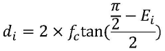
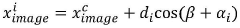
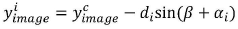
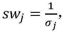
An urban canyon positioning method based on GNSS/vision/Lidar fusion
PatentActiveCN113376675B
Innovation
- Using a fusion method based on GNSS/vision/Lidar, a fisheye camera is used to determine satellite visibility, combined with supervised learning methods to further classify signal types, determine satellite weights for multi-constellation positioning calculations, and correct positioning errors through lidar ranging to improve Positioning accuracy.
Contextualization and refinement of simultaneous localization and mapping
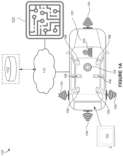
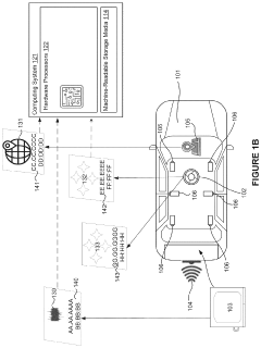
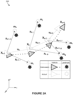
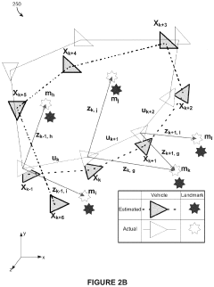
PatentActiveUS11908198B2
Innovation
- A computing system that generates maps using a SLAM algorithm, providing additional context by obtaining and depicting sensor data, determining positions and orientations, and displaying graphical illustrations of trajectory points and constraints, allowing for the selection and modification of constraints to refine the mapping process.
Robustness Testing Methodologies
Robustness testing methodologies for LiDAR SLAM systems in urban canyon environments with sparse GNSS require comprehensive evaluation frameworks that simulate real-world challenges. These methodologies must assess system performance under various degraded conditions that typically occur in dense urban settings.
Testing protocols should include controlled environment testing in laboratory settings where GNSS signal degradation can be artificially simulated with signal jammers or physical barriers. This allows for reproducible testing of system behavior when satellite visibility drops below critical thresholds. Parameters such as positioning accuracy, drift rates, and recovery time after signal loss should be systematically measured and documented.
Field testing in actual urban canyons represents a crucial component of robustness evaluation. Test routes should be carefully designed to include varying degrees of urban density, building heights, and street widths. These routes must be traversed multiple times under different weather and lighting conditions to ensure comprehensive performance assessment. During field tests, ground truth positioning data should be collected using high-precision reference systems for comparative analysis.
Stress testing methodologies involve deliberately creating challenging scenarios such as sudden GNSS outages, sensor occlusions, dynamic obstacles, and rapid vehicle maneuvers. The system's ability to maintain localization accuracy during these events provides valuable insights into its robustness limits. Metrics including recovery time, localization error accumulation rates, and feature tracking stability should be quantified.
Statistical validation approaches are essential for establishing confidence in system performance. Monte Carlo simulations with randomized environmental parameters can reveal edge cases and failure modes that might not be apparent in limited field testing. These simulations should incorporate realistic noise models for both LiDAR and GNSS sensors based on empirical data collected in urban environments.
Benchmark datasets specifically designed for urban canyon scenarios provide standardized testing platforms for comparative evaluation. These datasets should include synchronized LiDAR scans, GNSS measurements with varying quality indicators, IMU data, and precise ground truth trajectories. Performance metrics such as Absolute Trajectory Error (ATE) and Relative Pose Error (RPE) should be calculated against these benchmarks.
Long-duration testing is particularly important for evaluating system stability over extended operation periods. Tests spanning several hours can reveal drift accumulation patterns and potential system degradation that might not be apparent in shorter evaluation sessions. This approach is especially relevant for applications requiring continuous operation like autonomous delivery vehicles or mapping platforms.
Edge Computing for Real-time SLAM Processing
Edge computing represents a paradigm shift in how SLAM (Simultaneous Localization and Mapping) systems process data in challenging urban canyon environments where GNSS signals are sparse or unreliable. By distributing computational workloads between on-vehicle systems and edge servers, real-time SLAM processing can be significantly enhanced without requiring excessive onboard hardware.
The fundamental advantage of edge computing for LiDAR SLAM in urban canyons lies in its ability to process massive point cloud data with minimal latency. Traditional cloud-based approaches suffer from bandwidth limitations and communication delays, which are unacceptable for autonomous navigation systems requiring split-second decision-making capabilities. Edge computing addresses this by positioning computational resources closer to the data source.
In urban canyon scenarios, edge computing architectures typically employ a hybrid processing model. Raw LiDAR data undergoes initial preprocessing and feature extraction on the vehicle, while more computationally intensive tasks such as global map optimization and loop closure detection are offloaded to nearby edge servers. This distribution enables real-time performance even when GNSS signals are compromised by tall buildings and urban infrastructure.
Several technical implementations have emerged to optimize edge computing for SLAM in GNSS-challenged environments. Distributed SLAM frameworks like EdgeSLAM and Fog-SLAM partition computational tasks based on resource availability and urgency. These systems dynamically allocate processing resources depending on environmental complexity, with more resources dedicated to challenging urban canyon segments where GNSS reliability is lowest.
Edge computing also facilitates collaborative SLAM approaches, where multiple vehicles share processed LiDAR data through edge nodes. This collaborative aspect is particularly valuable in urban canyons, as vehicles can exchange localization information to compensate for individual GNSS limitations. Vehicles that momentarily have better satellite visibility can assist others navigating in deeper urban canyons through the edge computing infrastructure.
Recent advancements in edge hardware accelerators, including specialized FPGA and ASIC designs, have further enhanced real-time SLAM capabilities. These purpose-built processors can perform point cloud registration and feature matching operations at significantly higher speeds than general-purpose computing systems, enabling more sophisticated SLAM algorithms to run in real-time even with limited GNSS input.
The integration of 5G networks with edge computing creates additional opportunities for LiDAR SLAM systems in urban environments. The high bandwidth and low latency of 5G connections allow for more seamless offloading of computational tasks to edge servers, enabling more sophisticated SLAM algorithms that can better compensate for sparse GNSS conditions through enhanced environmental feature recognition and tracking.
Unlock deeper insights with Patsnap Eureka Quick Research — get a full tech report to explore trends and direct your research. Try now!
Generate Your Research Report Instantly with AI Agent
Supercharge your innovation with Patsnap Eureka AI Agent Platform!