
A super-resolution reconstruction method of remote sensing image based on deep convolutional neural network
A technology for super-resolution reconstruction and remote sensing images, applied in the field of digital image processing, can solve the problems of easy transition and smoothness of image edges, unstable training process, etc. Effect
Patent Information
- Authority / Receiving Office
- CN · China
- Patent Type
- Patents(China)
- Current Assignee / Owner
- Publication Date
- 2022-07-26
Smart Images
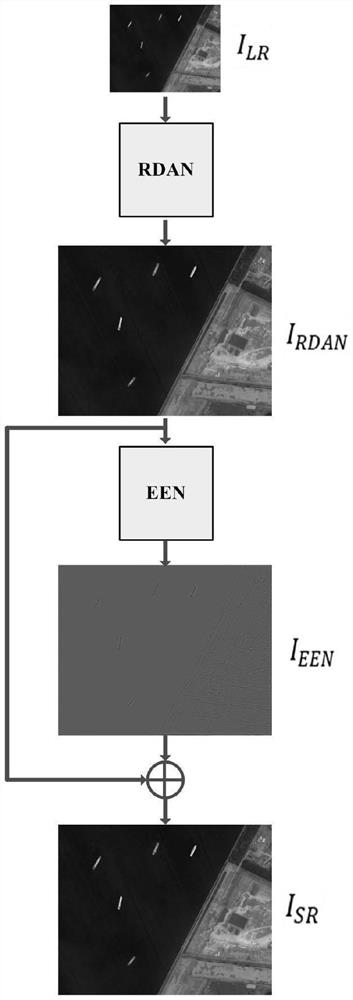
Figure 1 
Figure 2 
Figure 3
Abstract
Description
technical field
[0001] The invention relates to digital image processing, in particular to a method for super-resolution reconstruction of remote sensing images based on a deep convolutional neural network. Background technique
[0002] With the rapid development of modern aerospace technology, remote sensing images are more and more widely used in various fields, such as agricultural and forestry monitoring, military reconnaissance, urban planning, etc., and their resolution requirements are getting higher and higher. However, due to the limitation of hardware conditions and detection distance, there is still much room for improvement in the resolution and clarity of remote sensing images. Considering the high research cost of improving imaging sensors from the physical level and the long iterative development cycle of hardware, the reconstruction of low-resolution remote sensing images into high-resolution images from the algorithm level is becoming one of the current rese...
Examples
Embodiment Construction
[0085] The technical solutions in the embodiments of the present invention will be clearly and completely described below with reference to the accompanying drawings in the embodiments of the present invention. Obviously, the described embodiments are only a part of the embodiments of the present invention, rather than all the embodiments. Based on the embodiments of the present invention, all other embodiments obtained by those of ordinary skill in the art without creative efforts shall fall within the protection scope of the present invention.
[0086] figure 1 An overall block diagram of the super-resolution reconstruction of remote sensing images based on the deep residual attention network and the edge enhancement network is provided for the embodiments of the present invention. Let the input image be I LR , through the deep residual attention network output image I DRAN , I DRAN After passing through the edge enhancement network, the image I with the edge details in t...