Geophysical methods for detecting subsurface malachite deposits
AUG 19, 20259 MIN READ
Generate Your Research Report Instantly with AI Agent
Patsnap Eureka helps you evaluate technical feasibility & market potential.
Malachite Exploration Background and Objectives
Malachite, a copper carbonate hydroxide mineral, has been prized for its vibrant green color and use in jewelry and ornamental objects for millennia. However, its significance extends far beyond aesthetics, as malachite serves as an important indicator of copper deposits. The exploration and detection of subsurface malachite deposits have become increasingly crucial in the mining industry, driving the development of advanced geophysical methods.
The evolution of malachite exploration techniques has mirrored the broader advancements in geophysical prospecting. Early methods relied heavily on surface observations and basic geological mapping. As technology progressed, more sophisticated approaches emerged, incorporating geochemical analysis and remote sensing techniques. Today, the field stands at the cusp of a new era, with cutting-edge geophysical methods promising to revolutionize the detection of subsurface malachite deposits.
The primary objective of this technical research is to comprehensively evaluate the current state and future potential of geophysical methods for detecting subsurface malachite deposits. This involves assessing the efficacy of various techniques, including but not limited to, electrical resistivity tomography, induced polarization, ground-penetrating radar, and magnetic surveys. By analyzing these methods, we aim to identify their strengths, limitations, and areas for improvement in the context of malachite exploration.
Furthermore, this research seeks to explore the integration of multiple geophysical techniques to enhance detection accuracy and depth penetration. The synergistic use of complementary methods may provide a more comprehensive understanding of subsurface structures and mineral compositions, potentially leading to more efficient and cost-effective exploration strategies.
Another key objective is to investigate the application of machine learning and artificial intelligence in interpreting geophysical data for malachite detection. These advanced computational techniques have shown promise in enhancing the accuracy and speed of data analysis, potentially uncovering subtle patterns and anomalies that may indicate the presence of malachite deposits.
Lastly, this research aims to anticipate future trends and innovations in geophysical exploration techniques. By examining emerging technologies and their potential applications in malachite detection, we hope to provide valuable insights for long-term strategic planning in the mining industry. This forward-looking approach will help stakeholders prepare for and capitalize on upcoming advancements in the field of geophysical exploration for malachite and associated copper deposits.
Market Analysis for Malachite Resources
The global malachite market has shown steady growth in recent years, driven by increasing demand from various industries. Malachite, a copper carbonate hydroxide mineral, is primarily valued for its use in jewelry, ornamental objects, and as a source of copper ore. The market for malachite resources is closely tied to the broader copper industry, as well as the luxury goods and decorative arts sectors.
In the jewelry and ornamental market, malachite continues to be sought after for its distinctive green color and banding patterns. High-quality malachite specimens command premium prices, particularly in luxury markets such as China and the Middle East. The growing interest in natural, sustainable materials in jewelry design has further bolstered demand for malachite in recent years.
The industrial sector represents another significant market for malachite resources. As a copper ore, malachite is an important source of copper for various applications, including electronics, construction, and renewable energy technologies. The global push towards electrification and renewable energy has led to increased demand for copper, indirectly benefiting the malachite market.
Geographically, major markets for malachite resources include China, the United States, and European countries. China, in particular, has shown strong demand growth, driven by its expanding jewelry and industrial sectors. The African continent, especially countries like the Democratic Republic of Congo and Zambia, remains a key source of malachite deposits, influencing global supply dynamics.
Market analysts project continued growth in the malachite market over the coming years, with a compound annual growth rate (CAGR) expected to remain in the mid-single digits. This growth is anticipated to be driven by ongoing industrialization in developing economies, the expansion of renewable energy infrastructure, and sustained demand in the luxury goods sector.
However, the market faces challenges, including environmental concerns associated with mining activities and the need for sustainable extraction practices. These factors may influence future market dynamics and regulatory landscapes, potentially impacting supply and pricing structures in the malachite resource market.
Current Geophysical Methods and Challenges
Geophysical methods for detecting subsurface malachite deposits have evolved significantly over the years, with various techniques now available to exploration geologists. The current state of these methods encompasses a range of technologies, each with its own strengths and limitations.
Electromagnetic (EM) methods are widely used for malachite detection due to their sensitivity to conductive minerals. These techniques, including frequency-domain EM and time-domain EM, can penetrate to considerable depths and provide valuable information about subsurface conductivity anomalies. However, they may struggle in areas with high background conductivity or complex geological structures.
Magnetic surveys are another common approach, leveraging the magnetic properties of minerals associated with malachite deposits. While effective for identifying broad zones of mineralization, magnetic methods often lack the resolution needed for precise delineation of malachite bodies. They are also susceptible to interference from near-surface magnetic sources.
Induced Polarization (IP) has gained prominence in malachite exploration due to its ability to detect disseminated sulfides often associated with copper mineralization. IP surveys can provide information on both chargeability and resistivity, offering insights into the nature of subsurface materials. However, IP methods can be time-consuming and expensive, particularly for large-scale surveys.
Gravity surveys, while less commonly used for direct malachite detection, can provide valuable information about subsurface density variations that may indicate favorable host rock structures. These surveys are particularly useful when combined with other geophysical methods but can be affected by terrain and require careful data processing.
One of the primary challenges in current geophysical methods is the ambiguity in data interpretation. Malachite deposits often occur in complex geological settings, making it difficult to distinguish between the target mineral and other conductive or magnetic features. This necessitates the integration of multiple geophysical techniques and careful correlation with geological and geochemical data.
Another significant challenge is the depth limitation of many geophysical methods. As exploration targets become deeper, the resolution and sensitivity of surface-based geophysical surveys decrease. This has led to increased interest in borehole geophysical methods, which can provide higher resolution data at depth but are more invasive and costly.
The presence of conductive overburden or highly resistive layers can mask the geophysical response of underlying malachite deposits, presenting a significant challenge in certain geological environments. This issue often requires advanced processing techniques and careful survey design to overcome.
Environmental factors, such as rugged terrain or dense vegetation, can also pose logistical challenges for geophysical surveys, potentially limiting data quality or coverage. Additionally, the need for high-resolution, three-dimensional data to accurately model complex ore bodies has driven the development of more sophisticated data acquisition and processing techniques, which can be computationally intensive and require specialized expertise.
Existing Geophysical Solutions for Malachite Detection
01 Seismic data acquisition and processing
Advanced techniques for acquiring and processing seismic data to improve subsurface imaging and characterization. This includes methods for noise reduction, signal enhancement, and data interpretation to better understand geological structures and potential hydrocarbon reservoirs.- Seismic data acquisition and processing: This category focuses on methods and systems for acquiring and processing seismic data in geophysical exploration. It includes techniques for improving data quality, reducing noise, and enhancing the resolution of subsurface imaging. These methods often involve advanced signal processing algorithms and innovative data acquisition strategies to better understand geological structures and potential hydrocarbon reservoirs.
- Electromagnetic surveying techniques: Electromagnetic methods are used in geophysical exploration to detect and characterize subsurface structures based on their electrical properties. This category includes various techniques such as magnetotellurics, controlled-source electromagnetics, and ground-penetrating radar. These methods are particularly useful for identifying conductive bodies, mapping groundwater resources, and complementing seismic data in hydrocarbon exploration.
- Gravity and magnetic surveying: Gravity and magnetic surveying methods are used to measure variations in the Earth's gravitational and magnetic fields, respectively. These techniques help in identifying subsurface density and magnetic susceptibility contrasts, which can indicate the presence of geological structures, mineral deposits, or hydrocarbon reservoirs. Advanced processing and interpretation techniques are employed to enhance the resolution and accuracy of these surveys.
- Borehole geophysical measurements: This category encompasses various geophysical measurements conducted in boreholes or wells. It includes techniques such as well logging, vertical seismic profiling, and cross-well tomography. These methods provide high-resolution data on the physical properties of subsurface formations, helping to characterize reservoirs, assess formation properties, and correlate with surface geophysical data for improved subsurface imaging.
- Integration and interpretation of multi-method geophysical data: This category focuses on the integration and joint interpretation of data from multiple geophysical methods. It includes advanced data fusion techniques, machine learning algorithms, and visualization tools to combine information from various geophysical surveys. The goal is to provide a more comprehensive understanding of subsurface structures and properties by leveraging the strengths of different geophysical methods and resolving ambiguities in interpretation.
02 Electromagnetic surveying methods
Utilization of electromagnetic fields to investigate subsurface properties and structures. These methods involve transmitting electromagnetic signals into the earth and analyzing the received responses to detect variations in electrical conductivity, which can indicate the presence of minerals, hydrocarbons, or geological features.Expand Specific Solutions03 Gravity and magnetic surveying techniques
Application of gravity and magnetic measurements to map subsurface density and magnetic susceptibility variations. These methods are used to identify geological structures, mineral deposits, and hydrocarbon reservoirs by detecting anomalies in the Earth's gravitational and magnetic fields.Expand Specific Solutions04 Borehole geophysical logging
Methods for measuring various physical properties of rock formations surrounding a borehole. This includes techniques such as gamma-ray logging, resistivity logging, and sonic logging to provide detailed information about subsurface lithology, porosity, and fluid content.Expand Specific Solutions05 Integration of multiple geophysical methods
Combining data from various geophysical techniques to improve overall subsurface characterization and reduce uncertainty. This approach involves integrating seismic, electromagnetic, gravity, magnetic, and borehole data to create more comprehensive and accurate geological models.Expand Specific Solutions
Key Players in Geophysical Exploration Industry
The geophysical methods for detecting subsurface malachite deposits market is in a growth phase, driven by increasing demand for copper and technological advancements. The global market size is estimated to be in the hundreds of millions of dollars, with steady growth projected. Technologically, the field is moderately mature, with ongoing innovations. Key players like Shandong University, Chevron, Saudi Aramco, BGP Inc., and PetroChina are advancing research and applications. Academic institutions such as the Institute of Geology & Geophysics (CAS) and Sun Yat-Sen University contribute significantly to technological development. Smaller specialized firms like Willowstick Technologies and EnviroGene Ltd. are also making notable contributions, indicating a diverse and competitive landscape.
Saudi Arabian Oil Co.
Technical Solution: Saudi Aramco has developed a novel geophysical method for detecting subsurface malachite deposits using a combination of hyperspectral imaging and advanced seismic techniques. Their approach utilizes satellite-based hyperspectral sensors to identify surface indicators of malachite mineralization, such as specific vegetation patterns and soil alterations[2]. This data is then integrated with high-resolution 3D seismic surveys that employ both P-wave and S-wave analysis to map subsurface structures and potential ore bodies. The company has also developed proprietary algorithms that process the combined hyperspectral and seismic data to generate probability maps of malachite occurrences at various depths[4]. Additionally, Saudi Aramco employs passive seismic monitoring to detect micro-seismic events associated with fluid movement in fractured rock, which can indicate areas of increased mineralization potential[6].
Strengths: Innovative combination of remote sensing and seismic techniques, advanced data processing algorithms. Weaknesses: May be less effective in areas with thick overburden or complex surface features.
BGP, Inc.
Technical Solution: BGP, Inc. has developed a comprehensive geophysical approach for detecting subsurface malachite deposits, focusing on integrating multiple methods for enhanced accuracy. Their technique combines high-precision gravity and magnetic surveys with advanced electrical and electromagnetic methods. The gravity surveys utilize state-of-the-art superconducting gravimeters to detect minute density variations associated with malachite mineralization[7]. Magnetic surveys employ both ground and airborne magnetometers to map magnetic anomalies that may indicate alteration zones related to copper deposits. BGP's electrical methods include induced polarization (IP) and magnetotelluric (MT) surveys, which are particularly effective in detecting disseminated sulfide minerals often associated with malachite[9]. The company has also developed proprietary 3D inversion algorithms that integrate data from all these methods to create high-resolution subsurface models, significantly improving the accuracy of deposit delineation[11].
Strengths: Comprehensive multi-method approach, high-precision instrumentation, advanced data integration algorithms. Weaknesses: Time-consuming and potentially costly due to the multiple survey types required.
Innovative Geophysical Technologies for Malachite
Geophysical technique for mineral exploration and discrimination based on electromagnetic methods and associated systems
PatentActiveUS7324899B2
Innovation
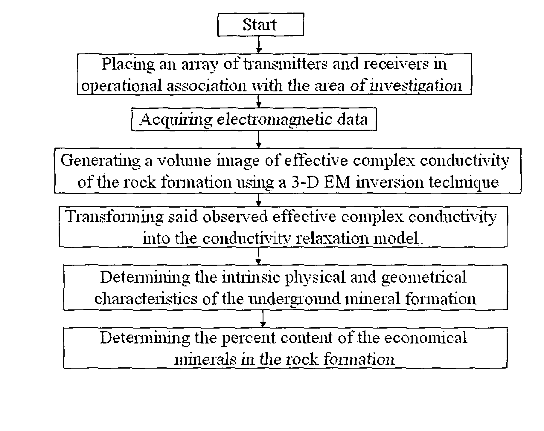
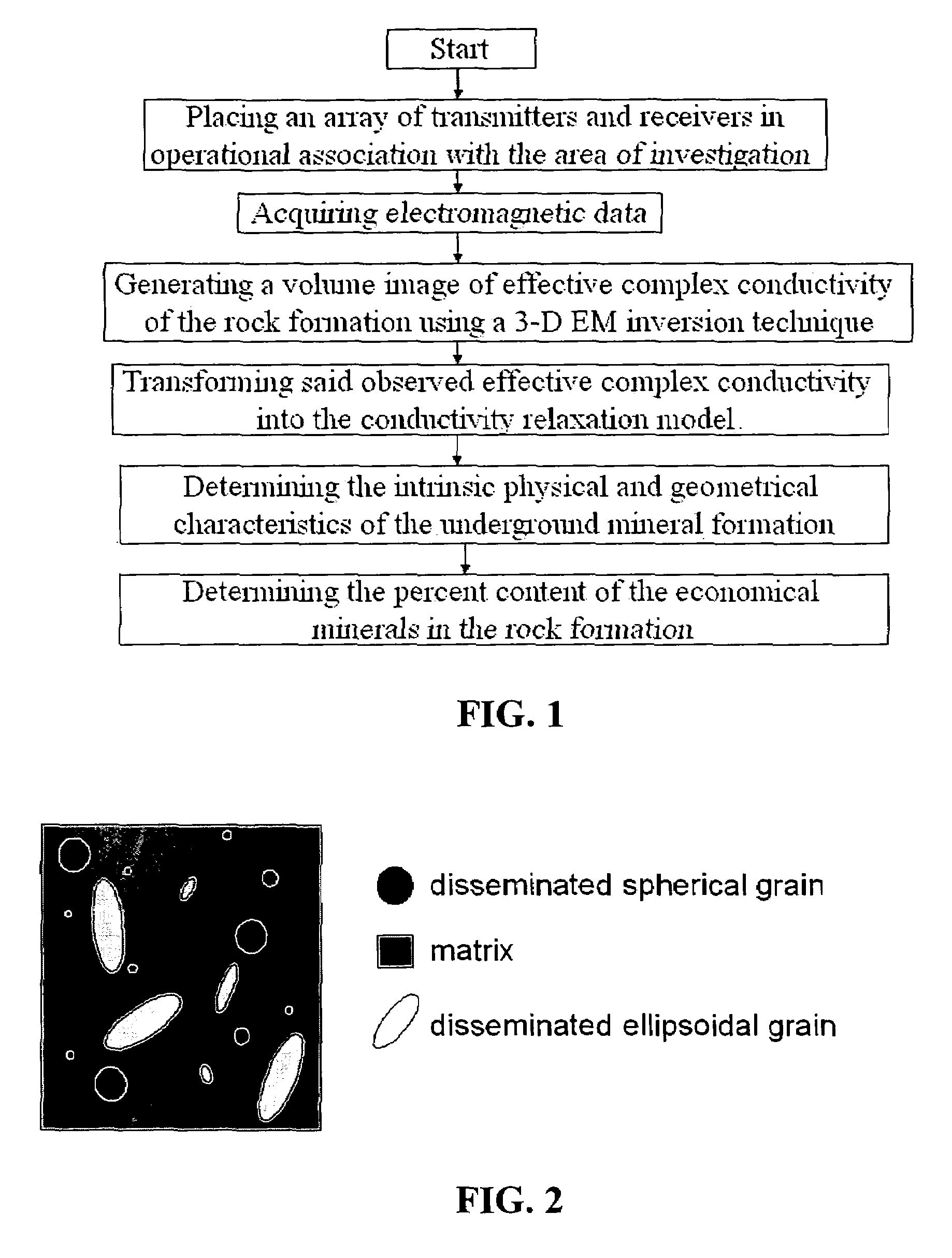
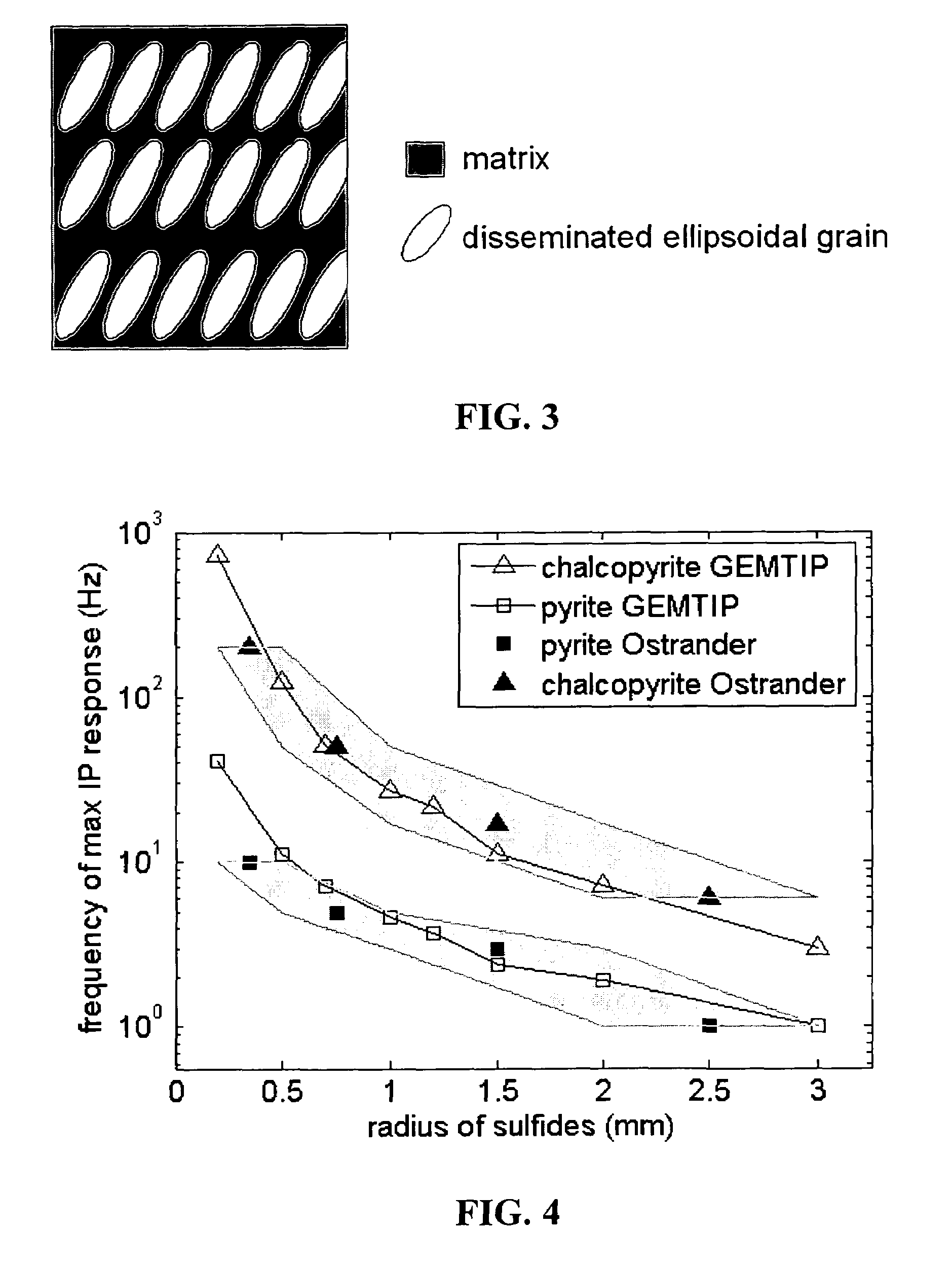
- A composite geoelectrical model and system that uses remote geophysical techniques to determine the 3-D distribution of conductivity relaxation parameters, allowing for the discrimination of different rock formations by analyzing electromagnetic data and transforming it into a conductivity relaxation model, which includes a generalized effective medium model for multiphase composite rock formations.

Method of detecting subsurface objects
PatentInactiveUS3745575A
Innovation
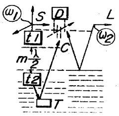
- A graded transition layer is created at the air-water or air-earth interface using a non-linear element and a half-wavelength space transformer, allowing electromagnetic waves to penetrate and reflect back from subsurface targets, enhancing detection visibility.

Environmental Impact of Geophysical Exploration
Geophysical exploration methods for detecting subsurface malachite deposits, while essential for mineral resource discovery, can have significant environmental impacts. These impacts vary depending on the specific techniques employed and the scale of operations. Surface-based methods such as magnetic and gravity surveys generally have minimal environmental footprints, as they involve portable equipment and limited ground disturbance.
However, more invasive techniques like seismic surveys can cause temporary disruptions to local ecosystems. The use of vibroseis trucks or small explosive charges to generate seismic waves may lead to soil compaction, vegetation damage, and temporary displacement of wildlife. These effects are typically short-term, with ecosystems recovering once operations cease.
Electromagnetic methods, including airborne surveys, have relatively low environmental impact but may cause temporary disturbances to local fauna due to aircraft noise. Ground-based electromagnetic surveys require the establishment of grids and the use of transmitters and receivers, which can result in minor vegetation clearing and soil disturbance.
Drilling operations, often used in conjunction with geophysical surveys for ground-truthing, have more substantial environmental implications. These include habitat fragmentation, soil erosion, and potential groundwater contamination if not properly managed. The construction of access roads and infrastructure to support exploration activities can also lead to long-term ecological changes in previously undisturbed areas.
Noise pollution from geophysical equipment and vehicles can disrupt wildlife behavior and breeding patterns. This is particularly concerning in sensitive habitats or during critical periods for endangered species. Additionally, the influx of personnel and equipment into remote areas may introduce invasive species or pathogens, potentially affecting local biodiversity.
Water resources can be impacted by geophysical exploration, particularly in arid regions where water is scarce. The use of water for drilling operations or dust suppression can strain local water supplies and affect aquatic ecosystems. There is also a risk of contamination from drilling fluids or accidental spills of fuels and lubricants used in exploration equipment.
To mitigate these environmental impacts, exploration companies are increasingly adopting best practices and technologies that minimize ecological disturbance. These include using low-impact vehicles, implementing strict waste management protocols, and conducting thorough environmental impact assessments before commencing operations. Rehabilitation efforts post-exploration are crucial to restore disturbed areas and promote ecosystem recovery.
Economic Viability of Malachite Detection Methods
The economic viability of malachite detection methods is a critical consideration for mining companies and geological exploration firms. Traditional methods of malachite detection, such as surface sampling and drilling, can be costly and time-consuming. Geophysical methods offer potential advantages in terms of efficiency and cost-effectiveness, but their economic viability must be carefully evaluated.
One of the primary factors influencing the economic viability of geophysical methods is their accuracy in detecting subsurface malachite deposits. Methods with higher accuracy rates can significantly reduce exploration costs by minimizing the need for extensive drilling programs. For instance, electromagnetic surveys have shown promising results in identifying conductive mineral deposits, including malachite, with relatively high precision.
The initial investment required for geophysical equipment and expertise is another crucial aspect of economic viability. While some methods may require substantial upfront costs, they can potentially offer long-term cost savings through more efficient exploration processes. For example, airborne geophysical surveys, although initially expensive, can cover large areas quickly, reducing the overall time and labor costs associated with ground-based exploration.
The scalability of geophysical methods also plays a role in their economic viability. Methods that can be easily scaled up to cover larger areas without proportional increases in cost are particularly attractive for large-scale exploration projects. Satellite-based remote sensing techniques, for instance, offer the advantage of covering vast territories at a relatively low cost per unit area.
Environmental impact and regulatory compliance are increasingly important factors in assessing the economic viability of malachite detection methods. Geophysical methods generally have a lower environmental footprint compared to invasive exploration techniques, potentially reducing costs associated with environmental remediation and regulatory compliance.
The integration of geophysical data with other exploration methods can enhance overall economic viability. By combining multiple geophysical techniques with geological mapping and limited drilling, companies can develop more comprehensive and accurate models of subsurface malachite deposits. This integrated approach can lead to more efficient resource allocation and higher success rates in identifying economically viable deposits.
Advancements in data processing and interpretation technologies are continually improving the economic viability of geophysical methods. Machine learning algorithms and artificial intelligence are enhancing the accuracy of data interpretation, potentially reducing the need for costly expert analysis and increasing the overall efficiency of the exploration process.
In conclusion, while the economic viability of geophysical methods for detecting subsurface malachite deposits varies depending on specific circumstances, these techniques offer significant potential for cost-effective and efficient exploration. As technology continues to advance and integration with other methods improves, the economic attractiveness of geophysical approaches is likely to increase further.
Unlock deeper insights with Patsnap Eureka Quick Research — get a full tech report to explore trends and direct your research. Try now!
Generate Your Research Report Instantly with AI Agent
Supercharge your innovation with Patsnap Eureka AI Agent Platform!