
Robust remote sensing image feature point pair extraction method for nonlinear radiation distortion
A remote sensing image and feature point pairing technology, applied in the field of remote sensing image processing, can solve the problems of low accuracy of satellite uncontrolled positioning and difficulty in fusion of heterogeneous information.
Patent Information
- Authority / Receiving Office
- CN · China
- Current Assignee / Owner
- Publication Date
- 2021-04-09
Smart Images
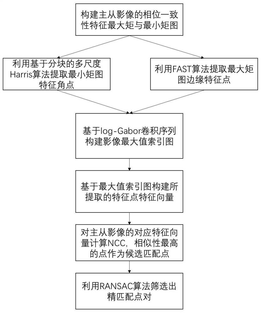
Figure 1 
Figure 2 
Figure 3
Abstract
Description
technical field
[0001] The invention belongs to the technical field of remote sensing image processing, in particular to a robust remote sensing image feature point pair extraction method facing nonlinear radiation distortion. Background technique
[0002] At present, multimodal remote sensing image feature matching has become a very important research direction in the field of remote sensing image processing. The matching information extracted from multimodal remote sensing image features can be widely used in many fields of national production and life and economic construction, such as natural disasters and environmental monitoring, multi-source information joint positioning, urban planning and major project construction, etc. However, the sources of multi-modal remote sensing images are different, and their resolution, spectrum, angle, and time details are different, which also brings great challenges to overcome the differences in heterogeneous image matching and improv...
Examples
Embodiment Construction
[0070] In order to better understand the contents of the present invention, an example is given here.
[0071] figure 1 It is a flow chart of the steps of the method for extracting accurate and robust feature points from multi-modal remote sensing images according to an embodiment of the present invention, as shown in figure 1 As shown, this embodiment discloses a robust remote sensing image feature point pair extraction method for nonlinear radiation distortion, and its specific steps are as follows:
[0072] S1. Perform image preprocessing on the two acquired multimodal remote sensing images, including:
[0073] S11, judging whether the acquired multi-modal remote sensing image is full-color black-and-white, if yes, transfer to S12, otherwise weighting the multi-modal remote sensing image into a black-and-white image;
[0074] S12, setting one image in the multimodal remote sensing image as the master image, and the other image as the slave image;
[0075] S13, respective...