
Method for representing soil components by using images
A technology for image representation and soil, which is applied in the field of image representation of soil components, and can solve problems such as inability to dynamically correct images
Patent Information
- Authority / Receiving Office
- CN · China
- Patent Type
- Applications(China)
- Current Assignee / Owner
- Publication Date
- 2021-05-07
Smart Images
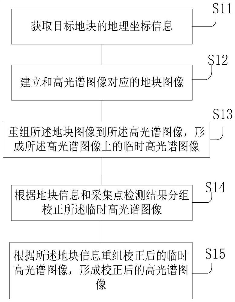
Figure 1 
Figure 2 
Figure 3
Abstract
Description
technical field
[0001] The invention relates to the technical field of soil components, in particular to a method for representing soil components with images. Background technique
[0002] Soil health is a key production factor in agriculture. Changes in soil composition directly affect crop yields and ecological environment, especially water environment and air quality. Knowledge of soil composition is key to managing, maintaining and improving soil fertility and agricultural productivity. Effective detection of soil composition and grasp of soil change trends are necessary means for the protection and supervision of cultivated land. At present, the methods of soil testing are mostly based on the collection of sample points, laboratory testing by chemical methods or physical and chemical methods, and then a test report is issued. The change of soil composition can only be analyzed through the long-term monitoring of fixed collection points and the analysis of the change...
Examples
Embodiment Construction
[0032] The implementation mode of the present invention is illustrated by specific specific examples below, and those who are familiar with this technology can easily understand other advantages and effects of the present invention from the contents disclosed in this description. Obviously, the described embodiments are a part of the present invention. , but not all examples. Based on the embodiments of the present invention, all other embodiments obtained by persons of ordinary skill in the art without making creative efforts belong to the protection scope of the present invention.
[0033] According to an embodiment of the present invention, a method for representing soil components with an image is provided, such as Figure 1 to Figure 6 shown, including:
[0034] S11. Obtain geographic coordinate information of the target plot;
[0035] S12. Establishing a plot image corresponding to the hyperspectral image;
[0036] S13. Reorganize the plot image into the hyperspectral...