
Method for laying orchard sensors
A sensor and orchard technology, used in instruments, scientific instruments, forecasting, etc., can solve the problems of insufficient accuracy, high sampling point cost, and insufficient accuracy and the number of sensors, so as to improve accuracy, reduce blindness, and save costs. Effect
Patent Information
- Authority / Receiving Office
- CN · China
- Current Assignee / Owner
- Publication Date
- 2018-08-03
Smart Images
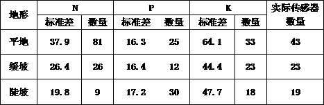
Figure 1
Abstract
Description
technical field
[0001] The invention relates to the technical field of orchard soil monitoring, in particular to a method for laying orchard sensors. Background technique
[0002] The rapid development of world agriculture in the second half of the 20th century was basically obtained under the conditions of a large amount of chemical fertilizers and pesticides and mineral energy, in addition to relying on the progress of biotechnology and the expansion of arable land and irrigated areas. However, the resulting ecological and environmental problems such as soil erosion, soil productivity decline, agricultural products and groundwater pollution, and water eutrophication have attracted widespread attention from the international community and promoted the emergence and development of sustainable agricultural development and precision agriculture. . The outstanding problems of my country's chemical fertilizer investment are unreasonable structure and low utilization rate. Low f...
Examples
Embodiment 1
[0024] There are two types of terrain in the orchard: flat land and gentle slope. The grids are divided at a distance of 500m, and then the grids are gradually refined until at least 80% of one grid is the same terrain. The grids of the same terrain are combined into one terrain. The blocks are labeled a1 and a2 respectively, among which there are 12 blocks in flat land a1 and 18 blocks in gentle slope a2;
[0025] Arrange the initial sampling points in the center of the grid, collect the content of N, P, and K, and obtain the basic data as shown in the following table:
[0026] flat ground:
[0027] nutrient
Mean value / mg·kg -1
standard deviation
initial sample number
N
92.11
16.5798
0.18
18
P
18.14
13.2422
0.73
18
K
83
31.54
0.38
18
[0028] Nutrient grading standards are shown in the table below:
[0029] nutrient
Extremely scarce
lack
Approp...
Embodiment 2
[0041] There are three types of terrain in the orchard: flat land, gentle slope, and steep slope. Firstly, the initial grid spacing is 500m, and then the grid is gradually refined and merged. There are 14 flat land a1, 10 gentle slope a2, and 6 steep slope a3. ;
[0042] Arrange initial sampling points in the center of the grid, collect the contents of N, P, and K, and obtain the basic data as follows:
[0043] flat ground
[0044] nutrient
Mean value / mg·kg -1
standard deviation
initial sample number
N
84.6
37.9
44%
14
P
28.6
16.3
57%
14
K
90.4
64.1
70%
14
[0045] Gentle slope: the slope is about 5°
[0046] nutrient
Mean value / mg·kg -1
standard deviation
coefficient of variation
initial sample number
N
78.7
26.4
33%
10
P
23.1
16.4
70%
10
K
84.2
44.4
52%
10
[0047] Steep slope: ...