Geographic Information System Applications in Battery Management Systems
AUG 8, 20259 MIN READ
Generate Your Research Report Instantly with AI Agent
Patsnap Eureka helps you evaluate technical feasibility & market potential.
GIS-BMS Integration Background and Objectives
The integration of Geographic Information Systems (GIS) with Battery Management Systems (BMS) represents a significant advancement in the field of energy storage and management. This convergence of technologies has emerged as a response to the growing complexity and scale of battery systems, particularly in the context of renewable energy integration and electric vehicle proliferation.
GIS, traditionally used for capturing, storing, analyzing, and presenting spatial or geographic data, has found a new application in enhancing the capabilities of BMS. The primary objective of this integration is to optimize battery performance, improve energy efficiency, and extend the lifespan of battery systems by leveraging spatial data and analytics.
The evolution of this technological synergy can be traced back to the early 2000s when the concept of smart grids began to gain traction. As distributed energy resources and electric vehicles became more prevalent, the need for sophisticated management systems that could handle complex spatial and temporal data became apparent. The GIS-BMS integration emerged as a solution to address these challenges.
One of the key drivers behind this integration is the increasing demand for more efficient and reliable energy storage solutions. With the global push towards renewable energy and electrification, battery systems have become critical components in various applications, from grid-scale energy storage to electric vehicle powertrains. The ability to manage these systems effectively while considering geographical factors has become paramount.
The GIS-BMS integration aims to achieve several specific objectives. Firstly, it seeks to enhance the spatial awareness of battery management systems, allowing for more accurate monitoring and control of distributed battery assets. This is particularly crucial in large-scale deployments where batteries may be spread across diverse geographical locations.
Secondly, the integration aims to improve predictive maintenance capabilities by incorporating environmental and location-based data. By analyzing factors such as temperature variations, altitude, and local weather patterns, the system can more accurately predict battery degradation and optimize maintenance schedules.
Another key objective is to optimize energy distribution and load balancing. By leveraging GIS data, BMS can make more informed decisions about energy routing, taking into account factors like grid topology, transmission distances, and local energy demand patterns. This can lead to significant improvements in overall system efficiency and reliability.
Furthermore, the GIS-BMS integration seeks to enhance safety and risk management in battery systems. By incorporating spatial data on factors like population density, proximity to critical infrastructure, and environmental sensitivities, the system can better assess and mitigate potential risks associated with battery failures or accidents.
As we delve deeper into this technological integration, it becomes clear that the convergence of GIS and BMS is not just an incremental improvement, but a transformative approach to energy storage management. It represents a shift towards more intelligent, context-aware systems that can adapt to the complex realities of modern energy landscapes.
Market Analysis for GIS-Enhanced BMS
The market for Geographic Information System (GIS) applications in Battery Management Systems (BMS) is experiencing significant growth, driven by the increasing adoption of electric vehicles (EVs) and the need for more efficient energy storage solutions. This integration of GIS technology with BMS offers numerous advantages, including improved battery performance, enhanced safety, and optimized energy management.
The demand for GIS-enhanced BMS is primarily fueled by the automotive industry, particularly the EV sector. As governments worldwide implement stricter emissions regulations and offer incentives for EV adoption, the market for advanced battery management solutions continues to expand. Major automotive manufacturers are investing heavily in EV technology, creating a substantial market opportunity for GIS-BMS integration.
Beyond the automotive sector, the renewable energy industry is another key driver for GIS-enhanced BMS. As solar and wind power installations grow, the need for efficient energy storage systems becomes crucial. GIS technology can help optimize the placement and management of large-scale battery storage facilities, enhancing grid stability and energy distribution.
The market potential for GIS-enhanced BMS extends to various other sectors, including telecommunications, aerospace, and consumer electronics. In the telecommunications industry, GIS can improve the management of backup power systems for cell towers and data centers. The aerospace sector can benefit from GIS-BMS integration for more efficient power management in aircraft and satellites.
Market analysts project substantial growth in the GIS-BMS market over the next decade. The increasing focus on smart cities and IoT applications is expected to further drive demand for advanced battery management solutions that incorporate geospatial data. This trend is likely to create new opportunities for companies specializing in GIS technology and battery management systems.
However, the market faces certain challenges, including the need for standardization in GIS-BMS integration and concerns about data privacy and security. Overcoming these hurdles will be crucial for widespread adoption across industries. Additionally, the market may experience some fragmentation due to the diverse range of applications and industry-specific requirements.
In terms of regional markets, North America and Europe currently lead in GIS-BMS adoption, primarily due to their advanced automotive and renewable energy sectors. However, the Asia-Pacific region, particularly China, is expected to show the fastest growth rate in the coming years, driven by rapid EV adoption and government support for clean energy initiatives.
Current GIS Applications in BMS
Geographic Information System (GIS) applications are increasingly being integrated into Battery Management Systems (BMS) to enhance the efficiency, safety, and performance of battery systems. Current GIS applications in BMS primarily focus on spatial data management, real-time monitoring, and predictive analytics.
One of the key applications of GIS in BMS is the optimization of battery placement and distribution. By leveraging spatial data and geographic analysis, BMS can determine the most effective locations for battery installations, considering factors such as energy demand patterns, grid infrastructure, and environmental conditions. This approach enables more efficient energy distribution and reduces transmission losses.
GIS is also being utilized for real-time monitoring of battery performance and health. By integrating GPS technology with BMS, the system can track the location and status of individual batteries or battery packs in large-scale deployments. This capability is particularly valuable for electric vehicle fleets and distributed energy storage systems, allowing operators to monitor battery state of charge, temperature, and other critical parameters across different geographic locations.
Another significant application is the use of GIS for predictive maintenance and failure analysis. By combining historical performance data with spatial information, BMS can identify patterns and trends that may indicate potential battery issues. This proactive approach helps in scheduling maintenance activities and preventing unexpected failures, thereby improving overall system reliability and longevity.
GIS applications in BMS also extend to route optimization for electric vehicles. By integrating battery performance data with geographic information, the system can calculate the most energy-efficient routes, taking into account factors such as terrain, traffic conditions, and charging station locations. This application not only enhances the range of electric vehicles but also contributes to more sustainable transportation practices.
Furthermore, GIS is being employed in BMS for energy demand forecasting and load balancing. By analyzing spatial patterns of energy consumption and correlating them with geographic and demographic data, BMS can predict future energy needs more accurately. This information is crucial for optimizing battery charging and discharging cycles, as well as for planning the expansion of energy storage infrastructure.
In the context of renewable energy integration, GIS applications in BMS play a vital role in managing the variability of solar and wind power generation. By incorporating weather data and geographical information, BMS can better predict renewable energy output and adjust battery storage strategies accordingly, ensuring a stable and reliable power supply.
Existing GIS Solutions for BMS
01 Data management and integration in GIS
Geographic Information Systems (GIS) focus on efficient data management and integration from various sources. This includes techniques for storing, retrieving, and analyzing spatial data, as well as methods for combining different types of geographic information to create comprehensive datasets for analysis and decision-making.- Data management and integration in GIS: Geographic Information Systems (GIS) focus on efficient data management and integration from various sources. This includes techniques for storing, retrieving, and analyzing spatial data, as well as methods for combining different data types such as vector and raster data. Advanced database management systems are often employed to handle large volumes of geographic information.
- Spatial analysis and visualization techniques: GIS systems incorporate advanced spatial analysis and visualization tools. These include methods for creating thematic maps, performing spatial queries, and conducting complex geospatial analyses. Visualization techniques often involve 3D rendering, interactive mapping, and the ability to overlay multiple data layers for comprehensive spatial understanding.
- Mobile and web-based GIS applications: The development of mobile and web-based GIS applications has expanded the accessibility and usability of geographic information. These applications often feature real-time data updates, location-based services, and cloud integration. They allow users to access and interact with spatial data on various devices, enhancing field data collection and decision-making processes.
- Integration of GIS with other technologies: Modern GIS systems are increasingly integrated with other technologies such as GPS, remote sensing, and Internet of Things (IoT) devices. This integration enables real-time data collection, improved accuracy in spatial analysis, and enhanced decision support capabilities. It also facilitates the development of smart city applications and environmental monitoring systems.
- GIS for urban planning and management: GIS plays a crucial role in urban planning and management. It provides tools for land use analysis, infrastructure planning, and environmental impact assessment. GIS-based systems help in optimizing resource allocation, managing utilities, and improving emergency response strategies in urban areas. They also support sustainable development initiatives by integrating various urban datasets.
02 Spatial analysis and visualization tools
GIS provides advanced spatial analysis and visualization tools for processing and displaying geographic data. These tools enable users to perform complex spatial queries, create thematic maps, and generate 3D visualizations to better understand and communicate spatial patterns and relationships.Expand Specific Solutions03 Mobile and web-based GIS applications
The development of mobile and web-based GIS applications has expanded the accessibility and usability of geographic information. These applications allow users to access and interact with spatial data on various devices, enabling real-time data collection, analysis, and sharing in the field.Expand Specific Solutions04 Integration of GIS with other technologies
GIS is increasingly integrated with other technologies such as GPS, remote sensing, and Internet of Things (IoT) devices. This integration enhances the accuracy and timeliness of spatial data collection and analysis, enabling more comprehensive and up-to-date geographic information systems.Expand Specific Solutions05 GIS for decision support and planning
Geographic Information Systems play a crucial role in decision support and planning across various sectors. GIS tools and methodologies are used to analyze spatial data for urban planning, environmental management, disaster response, and resource allocation, helping organizations make informed decisions based on geographic context.Expand Specific Solutions
Key Players in GIS and BMS Industries
The Geographic Information System (GIS) applications in Battery Management Systems (BMS) market is in its growth stage, with increasing adoption across various industries. The market size is expanding rapidly due to the rising demand for electric vehicles and renewable energy storage solutions. Technologically, the field is evolving quickly, with companies like Google, Apple, and HERE Global BV leading in GIS innovations. State Grid Corp. of China and BYD Co., Ltd. are making significant strides in integrating GIS with BMS for power grid management and electric vehicle applications. While the technology is maturing, there's still room for advancements in real-time data processing, predictive analytics, and seamless integration with IoT devices, indicating a dynamic and competitive landscape.
Google LLC
Technical Solution: Google has developed an advanced Geographic Information System (GIS) application for Battery Management Systems (BMS) that integrates machine learning algorithms with real-time geospatial data. This system utilizes Google Maps API and Earth Engine to provide precise location-based information for electric vehicle (EV) battery performance optimization. The application employs a sophisticated algorithm that considers factors such as terrain, traffic patterns, and weather conditions to predict battery usage and optimize charging strategies[1]. Additionally, Google's system incorporates crowdsourced data from millions of Android devices to enhance accuracy in predicting optimal charging locations and routes for EVs[3]. The BMS also leverages Google's expertise in big data analytics to process vast amounts of geospatial and battery performance data, enabling predictive maintenance and improving overall battery life cycles[5].
Strengths: Unparalleled access to geospatial data, advanced machine learning capabilities, and extensive user base for data collection. Weaknesses: Potential privacy concerns and dependence on continuous internet connectivity for real-time data updates.
Beijing Supermap Software Co., Ltd.
Technical Solution: Beijing Supermap Software has developed a comprehensive GIS-based Battery Management System that integrates 3D visualization and spatial analysis capabilities. Their solution utilizes SuperMap GIS technology to create detailed 3D models of urban environments, allowing for precise mapping of EV charging infrastructure and battery performance analysis[2]. The system incorporates real-time data from IoT sensors and GPS devices to track battery status, temperature, and charging patterns across different geographical locations. Supermap's BMS employs advanced spatial analysis algorithms to optimize charging station placement and predict battery degradation based on environmental factors[4]. The platform also features a user-friendly interface that allows fleet managers and individual EV owners to visualize battery health and charging opportunities on interactive 3D maps, enhancing decision-making and route planning[6].
Strengths: Strong 3D visualization capabilities, expertise in spatial analysis, and integration with IoT devices. Weaknesses: May have limited global reach compared to international competitors and potential challenges in data standardization across different regions.
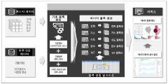
Core GIS Technologies for BMS
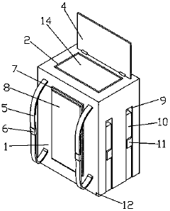
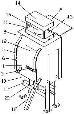
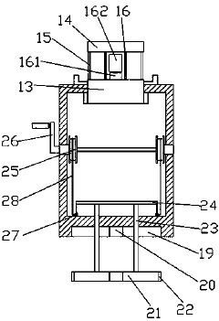
Terrain recording auxiliary device for power system planning
PatentPendingCN110657330A
Innovation
- A terrain recording auxiliary device for power grid planning is designed, including a square box, a glass cylinder, a stepper motor, a camera, a solar panel, a display screen, a backpack strap and other components. The stepper motor drives the camera to rotate and shoot 360-degree seamless shots. Dead-spot photos and easy to carry and transport via backpack straps.

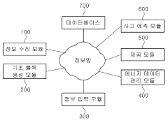
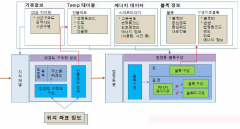
Geographic information system for proving blocking energy data and method for providing analysis result using the same
PatentActiveKR1020190046340A
Innovation
- A geographic information system that creates energy blocks using building coordinates, population census information, and business site information, assigning energy block IDs based on evaluation criteria, and provides analysis results for each block.

Data Privacy and Security Considerations
The integration of Geographic Information Systems (GIS) with Battery Management Systems (BMS) introduces significant data privacy and security considerations. As these systems collect, process, and store sensitive information about battery performance, vehicle locations, and user behavior, robust measures must be implemented to protect this data from unauthorized access and potential misuse.
One primary concern is the protection of location data. GIS-enabled BMS can track the precise movements of electric vehicles, potentially revealing sensitive information about users' daily routines, frequently visited locations, and travel patterns. This data, if compromised, could be exploited for malicious purposes such as targeted theft or surveillance. To mitigate these risks, encryption protocols for data transmission and storage must be implemented, along with strict access controls and user authentication mechanisms.
Another critical aspect is the security of battery performance data. This information can provide insights into a vehicle's range, charging patterns, and overall efficiency. In the wrong hands, such data could be used for competitive intelligence or to exploit vulnerabilities in the power grid. Implementing secure data storage solutions, such as distributed ledger technologies or secure cloud services with end-to-end encryption, can help safeguard this sensitive information.
Data anonymization techniques play a crucial role in preserving user privacy while still allowing for valuable data analysis. By removing or obfuscating personally identifiable information before processing or sharing data, organizations can maintain user confidentiality while benefiting from aggregated insights. However, care must be taken to ensure that anonymization methods are robust against re-identification attacks, which attempt to link anonymized data back to specific individuals.
The interconnected nature of GIS and BMS also raises concerns about potential cyber-attacks. As these systems often rely on wireless communication and internet connectivity, they become potential targets for hackers seeking to disrupt operations or gain unauthorized access to sensitive data. Implementing robust firewalls, intrusion detection systems, and regular security audits is essential to maintain the integrity of these systems.
Compliance with data protection regulations, such as GDPR in Europe or CCPA in California, is another critical consideration. These regulations mandate specific requirements for data handling, user consent, and the right to be forgotten. Organizations must ensure that their GIS-BMS integration adheres to these regulations, implementing features such as data portability and the ability for users to request the deletion of their personal information.
In conclusion, while the integration of GIS with BMS offers significant benefits for electric vehicle management and optimization, it also introduces complex data privacy and security challenges. Addressing these concerns requires a multi-faceted approach, combining technical solutions with robust policies and user education to ensure the responsible and secure use of this powerful technology.
Environmental Impact Assessment
The integration of Geographic Information Systems (GIS) with Battery Management Systems (BMS) presents significant opportunities for environmental impact assessment in the context of electric vehicle (EV) adoption and renewable energy storage. This synergy allows for a comprehensive evaluation of the environmental implications associated with battery lifecycle management, from raw material extraction to end-of-life disposal.
GIS applications in BMS enable the mapping and analysis of battery production facilities, distribution networks, and recycling centers. This spatial information helps in optimizing supply chains and reducing transportation-related emissions. By visualizing the geographical distribution of battery manufacturing and recycling facilities, stakeholders can identify areas of high environmental stress and implement targeted mitigation strategies.
Furthermore, GIS-enhanced BMS can contribute to more efficient energy management in smart grids. By integrating real-time data on battery performance, energy consumption patterns, and renewable energy generation, these systems can optimize energy distribution and storage. This leads to reduced reliance on fossil fuels and lower greenhouse gas emissions.
The environmental impact of battery raw material extraction can also be assessed more accurately using GIS. By mapping mining locations and overlaying this information with ecological data, researchers can identify potential habitat disruptions, water pollution risks, and land use changes. This information is crucial for developing sustainable mining practices and selecting environmentally responsible suppliers.
GIS applications in BMS also facilitate the assessment of battery recycling and disposal impacts. By tracking the movement of end-of-life batteries and visualizing recycling facility locations, authorities can ensure proper disposal practices and minimize environmental contamination. This spatial analysis can help in identifying optimal locations for new recycling facilities, considering factors such as transportation distances and local environmental sensitivities.
The integration of GIS with BMS allows for more accurate lifecycle assessments of batteries. By incorporating spatial data on energy sources, transportation routes, and usage patterns, researchers can develop more comprehensive models of battery environmental impacts. This can lead to the development of more sustainable battery technologies and improved environmental policies.
Moreover, GIS-enhanced BMS can contribute to urban planning and infrastructure development for EVs. By analyzing the spatial distribution of charging stations, traffic patterns, and energy demand, planners can optimize the placement of charging infrastructure. This not only improves the efficiency of EV adoption but also minimizes the environmental impact of infrastructure development.
In conclusion, the application of GIS in Battery Management Systems significantly enhances our ability to assess and mitigate the environmental impacts of battery technologies. This integration provides valuable insights for policymakers, manufacturers, and consumers, promoting more sustainable practices in the rapidly growing field of energy storage and electric mobility.
Unlock deeper insights with Patsnap Eureka Quick Research — get a full tech report to explore trends and direct your research. Try now!
Generate Your Research Report Instantly with AI Agent
Supercharge your innovation with Patsnap Eureka AI Agent Platform!